Skip to search
Skip to main content
Skip to first result
Yale University Library
Ask Yale Library
Reserve Rooms
Places to Study
Research
Quicksearch
Search Library Catalog (Orbis)
Search Law Library Catalog (MORRIS)
Search Borrow Direct
Search WorldCat
Search Articles+
Search Digital Collections
Search Archives at Yale
Research Guides
Find Databases by Title
Find eJournals by Title
Guide to Using Special Collections
Services
Your Personal Librarian
Subject Specialists
Research Support and Workshops
Citation Tools
OverDrive: Popular Audio and eBooks
Get It @ Yale (Borrow Direct, Interlibrary Loan, Scan & Deliver)
Course Reserves
Off-Campus Access
EliScholar
OverDrive: Popular Audio and eBooks
Bass Media Equipment
Libraries & Collections
Arts Library
Bass Library
Beinecke Library
Classics Library
Divinity Library
Film Study Center
Fortunoff Archive
Humanities Collections
International Collections
Law Library
Lewis Walpole Library
Library Collection Services
Manuscripts & Archives
Map Collection
Marx Science & Social Science Library
Medical Library
Music Library
Sterling Library
Yale Center for British Art
Information & Policies
Library Hours
Departments & Staff
Borrowing & Circulation
Services for Persons with Disabilities
Copyright Basics
Scanning, Printing & Copying
Computers & Wireless
Library Policies
About the Library
Giving to the Library
Purchase Request
Working at the Library
Terms Governing Use of Materials
Search in
All Fields
Creator
Title
Call Number
Date
Subject
Orbis ID
Full Text
Description
Full text
search for
Search
Search
Advanced Search
Digital Collections
Search
You Searched For
Access
Public
Format
cartographic
Creator
Geological Survey (U.S.)
Publication Place
[Washington, D.C.] :
New Search
« Previous
|
1
-
50
of
56
|
Next »
Sort
by Title (Z --> A)
relevance
Creator (A --> Z)
Creator (Z --> A)
Title (A --> Z)
Title (Z --> A)
Year (ascending)
Year (descending)
Number of results to display per page
50
per page
9
per page
30
per page
60
per page
99
per page
View results as:
List
List
Gallery
Gallery
Search Results
Yellowstone National Park and north western Wyoming / U.S. Geological Survey ; Henry Gannett, Chief
Wyoming-South Dakota, Newcastle quadrangle : land classification and density of standing timber
Wyoming, Dayton quadrangle : land classification and density of standing timber / U.S. Geological
Wyoming, Cloud Peak quadrangle : land classification and density of standing timber / U.S
Wyoming, Bald Mountain quadrangle : land classification and density of standing timber / U.S
Washington-Idaho, Spokane quadrangle : land classification and density of standing timber / U.S
Washington, Mount Stuart quadrangle : land classification and density of standing timber / U.S
Washington, Ellensburg quadrangle : land classification and density of standing timber / U.S
Washington, Chelan quadrangle : land classification and density of standing timber / U.S
Virginia, Norfolk special map / topography by U.S. Geological Survey ; control and shore topography
Utah : Tintic mining map.
United States relief map / U.S. Geological Survey, Department of the Interior ; compiled by Henry
Topography of Kasaan Peninsula, Prince of Wales Island, Alaska / Alfred H. Brooks, geologist in
Topographic sheet, Montana (Silver Bow Co.) : Butte special map / Henry Gannett, chief topographer
Topographic reconnaissance map of Upper Tanana River Valley region, Alaska / U.S. Geological Survey
Topographic reconnaissance map of Innoko-Iditarod region, Alaska / Geological Survey.
Topographic map of the Yellowstone National Park, Wyoming-Montana-Idaho / from Geological Survey
Topographic map of Solomon quadrangle, Alaska.
Topographic map of Lower Matanuska Valley, Alaska / Department of the Interior, U.S. Geological
Stations and transmission lines used in public service : [Massachusetts, Rhode Island and
State of Minnesota / Department of the Interior, Franklin K. Lane, Secretary, Geological Survey
Southern California.
Reconnaissance map of the Lower Kuskokwim region, Alaska / U.S. Geological Survey ; Alfred H
Reconnaissance map of northeastern portion of Seward Peninsula Alaska / U.S. Geological Survey
Reconnaissance map of Yukon-Koyukuk region, Alaska / U.S. Geological Survey; Alfred H. Brooks
Reconnaissance map of Ruby district, Alaska / U.S. Geoogical Survey; Alfred H. Brooks, geologist in
Reconnaissance map of Koyukuk-Chandalar region, Alaska / U.S. Geological Survey ; Alfred H. Brooks
Philadelphia and vicinity, Pennsylvania - New Jersey and Delaware.
Oregon, Roseburg quadrangle : land classification and density of standing timber / U.S. Geological
Oregon, Port Orford quadrangle : land classification and density of standing timber / U.S
Oregon, Coos Bay quadrangle : land classification and density of standing timber / U.S. Geological
Map showing condition and progress of topographic surveys and location of gaging stations for the
Map showing condition and progress of astronomic location, primary triangulation, primary traverse
Map showing Indian Reservations within the Limits of the United States, 1913 / engraved and printed
Map of Yosemite Valley, Yosemite National Park, California, Mariposa County / U.S. Geological
Map of Western Washington showing density of merchantable timber / U.S. Geological Survey.
Map of Saybrook area, Connecticut, showing rock outcrops, wooded areas, and ground-water conditions.
Map of North America : reduced from map on scale of 1:5,000,000 / compiled by the U.S. Geological
Map of Connecticut / prepared by the U.S. Geological Survey in co-operation with the State of
Map of Alaska showing the known distribution of mineral resources / U.S. Geological Survey
Map of Alaska / compiled chiefly from maps of the U.S. Geological Survey ... Alfred H. Brooks
Leadville mining district [cartographic material] / U.S. Geological Survey ; R.B. Marshall, chief
Land classification and density of standing timber, Washington, Tacoma quadrangle / U.S. Geological
Land classification and density of standing timber, Washington, Seattle quadrangle / U.S
Juneau and vicinity, Alaska / Alfred H. Brooks, geologist in charge of division ; topography by D.C
Geologic reconnaissance map of headwater region of Gulkana and Susitna Rivers, Alaska / U.S
PREVIOUS
«
1
2
»
NEXT
Limit your search
Extent of Digitization
Completely digitized
56
Access
Public
✖
[remove]
56
Repository
Beinecke Rare Book and Manuscript Library
56
Format
cartographic
✖
[remove]
56
Genre
Maps
37
Topographic maps
22
Resource Type
Maps, Atlases & Globes
56
Language
English
56
Creator
Geological Survey (U.S.)
✖
[remove]
56
Subject (Topic)
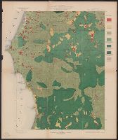
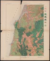
Forests and forestry--Oregon--Coos County--Maps
2
Forests and forestry--Washington (State)--Chelan County--Maps
2
Forests and forestry--Washington (State)--King County--Maps
2
Forests and forestry--Washington (State)--Kittitas County--Maps
2
Forests and forestry--Wyoming--Big Horn County--Maps
2
Forests and forestry--Wyoming--Sheridan County--Maps
2
Land capability for agriculture--Oregon--Coos County--Maps
2
Land capability for agriculture--Wyoming--Big Horn County--Maps
2
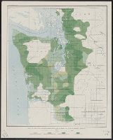
Land use--Washington (State)--King County--Maps
2
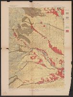
Mines and mineral resources--Colorado--Leadville--Maps.
2
more
Subject (Topic)
»
Subject (Name)
Geological Survey (U.S.). Annual report
12
Gannett, Henry, 1846-1914
9
Brooks, Alfred H. (Alfred Hulse), 1871-1924
8
Plummer, Fred G. (Fred Gordon), 1864-1913
4
Tweedy, Frank, 1854-1937
4
Witherspoon, D. C
4
Johnson, A. J
3
Julius Bien & Co
3
Marshall, R. B. (Robert Bradford), 1867-1949
3
Barnard, E. C. (Edward Chester), 1863-1921
2
more
Subject (Name)
»
Publication Place
[Washington, D.C.] :
✖
[remove]
56
Date Created
View distribution
Current results range from
1880
to
1939
Date Created range begin
Date Created range end
View larger »