Search
You Searched For
Search Results
- Published / Created:
- Aug. 25, 1888.
- Call Number:
- Print10207
- Image Count:
- 1
- Resource Type:
- still image
- Found in:
- Medical Historical Library, Cushing/Whitney Medical Library > "What are the wild waves saying?" Try Beecham's Pills. [graphic]
- Creator:
- Russell, John, fl. 1733-1795
- Published / Created:
- 1794 July 26
- Call Number:
- 1986 102
- Collection Title:
- An historical, geographical, commercial, and philosophical view of the American United States, and
- Image Count:
- 1
- Found in:
- Beinecke Rare Book and Manuscript Library > A General map of North America drawn from the best sources
- Published / Created:
- 1776
- Call Number:
- Cb23 27
- Collection Title:
- The American military pocket atlas : being an approved collection of correct maps, both general and
- Image Count:
- 1
- Found in:
- Beinecke Rare Book and Manuscript Library > A General map of the northern British colonies in America. which comprehends the province of Quebec, the government of Newfoundland, Nova-Scotia, New-England and New-York. From the maps published by the Admiralty and Board of Trade regulated by the astronomic and trigonometric observations of M. von Holland and corrected from Governor Pownall's late map 1776.
- Creator:
- Romans, B
- Published / Created:
- 1776
- Call Number:
- Cb23 27
- Collection Title:
- The American military pocket atlas : being an approved collection of correct maps, both general and
- Image Count:
- 1
- Found in:
- Beinecke Rare Book and Manuscript Library > A General map of the southern British colonies, in America, comprehending North and South Carolina, Georgia, east and west Florida, with the neighbouring Indian countries. From the modern surveys of engineer de Brahm, Capt. Collet, Mouzon & others; and from the large hydrographical survey of the coasts of east and west Florida
- Creator:
- Brasier, William
- Published / Created:
- 1776
- Call Number:
- Cb23 27
- Collection Title:
- The American military pocket atlas : being an approved collection of correct maps, both general and
- Image Count:
- 1
- Found in:
- Beinecke Rare Book and Manuscript Library > A Survey of Lake Champlain, including Lake George, Crown Point and St. John. Surveyed by order of His Excellency Major General Sr. Jeffery Amherst, knight of the most honble. Order of the Bath, Commander in Chief of His Majesty's forces in North America (now Lord Amherst) by William Brassier, draughtsman, 1762
- Published / Created:
- 1795
- Call Number:
- 1986 102
- Collection Title:
- An historical, geographical, commercial, and philosophical view of the American United States, and
- Image Count:
- 1
- Found in:
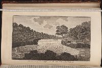
- Beinecke Rare Book and Manuscript Library > A View of Ohiopyle Falls in Pennsylvania
- Creator:
- Delarochette, L. (Louis), 1731-1802, creator
Faden, William, 1749-1836
Palmer, William, 1750-1836
- Published / Created:
- 1784 March 1
- Call Number:
- 1982 Folio 10
- Image Count:
- 1
- Found in:
- Beinecke Rare Book and Manuscript Library > A chart of the Antilles, or, Charibbee, or, Caribs Islands, with the Virgin Isles
- Creator:
- Delarochette, L. (Louis), 1731-1802
Dicquemare, (Jacques-Francois), M. l'abbe, 1733-1789, creator
Faden, William, 1749-1836
- Published / Created:
- 1780 June 17
- Call Number:
- 1982 Folio 10
- Image Count:
- 1
- Found in:
- Beinecke Rare Book and Manuscript Library > A chart of the British Channel and the Bay of Biscay with a part of the North Sea, and the entrance of St. George's Channel
- Creator:
- Delarochette, L. (Louis), 1731-1802, creator
- Published / Created:
- 1780 June 28
- Call Number:
- 1982 Folio 10
- Image Count:
- 1
- Found in:
- Beinecke Rare Book and Manuscript Library > A chart of the coasts of Spain and Portugal, with the Balearic Islands, and part of the coast of Barbary
- Creator:
- Delarochette, L. (Louis), 1731-1802, creator
- Published / Created:
- 1781 January 1
- Call Number:
- 1982 Folio 10
- Image Count:
- 1
- Found in:
- Beinecke Rare Book and Manuscript Library > A chart of the islands of Jersey and Guernsey, Sark, Herm and Alderney, with the adjacent coast of France
- Creator:
- Wilson, George, b. 1631 or 2
- Published / Created:
- 1698
- Call Number:
- QD27 W54 1698
- Image Count:
- 202
- Found in:
- Beinecke Rare Book and Manuscript Library > A compleat course of chymistry : containing near three hundred operations, several of which have not been publish’d before : also the structure of several furnaces, with near three hundred characters, which are dispers’d in chymical authors, and such instruments and vessels as are necessary in a compleat elaboratory : all cut in copper / by George Wilson
- Creator:
- Vaughan, Robert, 17th cent., engraver
- Published / Created:
- 1624
- Call Number:
- 2003 +39
- Collection Title:
- The generall historie of Virginia, New-England, and the Summer Iles ...
- Image Count:
- 1
- Found in:
- Beinecke Rare Book and Manuscript Library > A description of part of the adventures of Cap. Smith in Virginia
- Creator:
- Vaughan, Robert, 17th cent., engraver
- Published / Created:
- 1624
- Call Number:
- Pequot +Sm4
- Collection Title:
- The generall historie of Virginia, New-England, and the Summer Isles : with the names of the
- Image Count:
- 1
- Found in:
- Beinecke Rare Book and Manuscript Library > A description of part of the adventures of Cap. Smith in Virginia
- Published / Created:
- 1776
- Call Number:
- Cb23 27
- Collection Title:
- The American military pocket atlas : being an approved collection of correct maps, both general and
- Image Count:
- 1
- Found in:
- Beinecke Rare Book and Manuscript Library > A general map of the middle British colonies in America. Containing Virginia, Maryland, the Delaware counties, Pennsylvania and New Jersey. With the addition of New York, and of the greatest part of New England, as also of the bordering parts of the province of Quebec, improved from several surveys made after the late war, and corrected from Governor Pownall's late map 1776.
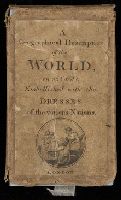
- Published / Created:
- [1815?]
- Call Number:
- PLAYING CARDS GEN 397
- Image Count:
- 35
- Resource Type:
- text and still image
- Found in:
- Beinecke Rare Book and Manuscript Library > A geographical description of the world : on 32 cards ; embellished with the dresses of the various nations
- Creator:
- Faden, William, 1749-1836
Rennell, James, 1742-1830, creator
- Published / Created:
- 1786 January 1
- Call Number:
- 1982 Folio 10
- Image Count:
- 1
- Found in:
- Beinecke Rare Book and Manuscript Library > A map of Bengal, Bahar, Oude & Allahabad with part of Agra and Delhi : exhibiting the course of the Ganges from Hurdwar to the sea
- Creator:
- Anville, Jean Baptiste Bourguignon d', 1697-1782
Kitchin, Thomas, d. 1784
Sayer, Robert, 1725-1794, creator
- Published / Created:
- 1787 July 1
- Call Number:
- 1982 Folio 10
- Image Count:
- 2
- Found in:
- Beinecke Rare Book and Manuscript Library > A map of South America : containing Tierra-Firma, Guayana, New Granada, Amazonia, Brasil, Peru, Paraguay, Chaco, Tucuman, Chili and Patagonia : from Mr. d'Anville with several improvements and additions, and the newest discoveries
- Creator:
- Faden, William, 1749-1836, creator
- Published / Created:
- 1789 January 1
- Call Number:
- 1982 Folio 10
- Image Count:
- 1
- Found in:
- Beinecke Rare Book and Manuscript Library > A map of the Austrian possessions in the Netherlands or Low Countries, with the principalities of Liege and Stavelo, & ca : reduced from the trigonometric survey made by order of H.R.H. the Prince Charles of Lorraine
- Creator:
- Faden, William, 1749-1836, creator
- Published / Created:
- 1785 March 1
- Call Number:
- 1982 Folio 10
- Image Count:
- 2
- Found in:
- Beinecke Rare Book and Manuscript Library > A map of the Mediterranean Sea, with the adjacent regions and seas in Europe, Asia, and Africa
- Creator:
- Faden, William, 1749-1836, creator
- Published / Created:
- 1789 January 1
- Call Number:
- 1982 Folio 10
- Image Count:
- 1
- Found in:
- Beinecke Rare Book and Manuscript Library > A map of the seven united provinces, with the land of Drent, and the generality Lands
- Creator:
- Berry, William, fl. 1669-1708, creator
Sanson, Nicolas, 1600-1667
- Published / Created:
- 1680
- Call Number:
- 1973 Folio 10
- Image Count:
- 1
- Resource Type:
- Maps, Atlases & Globes
- Found in:
- Beinecke Rare Book and Manuscript Library > A mapp of all the world in two hemispheres in which are exactly described all the parts of the earth and seas
- Creator:
- Browne, Christopher, fl. 1684-1712, creator
- Published / Created:
- [169-?]
- Call Number:
- 1973 Folio 10
- Image Count:
- 1
- Resource Type:
- Maps, Atlases & Globes
- Found in:
- Beinecke Rare Book and Manuscript Library > A new chart of the sea coasts of France: together with the English Chanell describing ye severall harbors, sands, rocks, and anchoridges, etc. on the said coasts
- Creator:
- Faden, William, 1749-1836, creator
- Published / Created:
- 1787 January 1
- Call Number:
- 1982 Folio 10
- Image Count:
- 1
- Found in:
- Beinecke Rare Book and Manuscript Library > A new general chart of the world : exhibiting the whole of the discoveries made by the late Captain James Cook, F.R.S. with the tracks of the ships under his command : also those of Cap'n Phipps (now Lord Mulgrave) in his expedition to the North Pole
- Creator:
- Beaufort, Daniel Augustus, 1739-1821, creator
Faden, William, 1749-1836
- Published / Created:
- 1792
- Call Number:
- 1982 Folio 10
- Image Count:
- 2
- Found in:
- Beinecke Rare Book and Manuscript Library > A new map of Ireland, civil and ecclesiastical
- Creator:
- Faden, William, 1749-1836, creator
- Published / Created:
- 1788 June 24
- Call Number:
- 1982 Folio 10
- Image Count:
- 2
- Found in:
- Beinecke Rare Book and Manuscript Library > A new map of the German empire and the neighbouring states with their principal post roads : originally published by the Royal Academy of Berlin
- Creator:
- Faden, William, 1749-1836
Jefferys, Thomas, d. 1771, creator
- Published / Created:
- 1789 June 1
- Call Number:
- 1982 Folio 10
- Image Count:
- 1
- Found in:
- Beinecke Rare Book and Manuscript Library > A new map of the King of Great Britain's dominions in Germany or the electorate of Brunswick-Luneburg and its dependencies
- Creator:
- Kitchin, Thomas, d. 1784, creator
Sayer, Robert, 1725-1794
- Published / Created:
- 1787 January 1
- Call Number:
- 1982 Folio 10
- Image Count:
- 1
- Found in:
- Beinecke Rare Book and Manuscript Library > A new map of the Kingdom of Poland with its dismembered provinces
- Creator:
- Sayer, Robert, 1725-1794, creator
- Published / Created:
- 1788 October 10
- Call Number:
- 1982 Folio 10
- Image Count:
- 1
- Found in:
- Beinecke Rare Book and Manuscript Library > A new map of the Northern States containing the Kingdoms of Sweden, Denmark, and Norway, with the western parts of Russia, Livonia, Courland &ca
- Creator:
- Browne, Christopher, fl. 1684-1712, bookseller
Morden, Robert, d. 1703, creator
- Published / Created:
- [168-?]
- Call Number:
- 1973 Folio 10
- Image Count:
- 1
- Resource Type:
- Maps, Atlases & Globes
- Found in:
- Beinecke Rare Book and Manuscript Library > A new map of the estates of Savoy [and] Piedmont: with the countries adjacent
- Creator:
- Anville, Jean Baptiste Bourguignon d', 1697-1782
Pownall, Thomas, 1722-1805
Sayer, Robert, 1725-1794, creator
- Published / Created:
- 1786
- Call Number:
- 1982 Folio 10
- Image Count:
- 2
- Found in:
- Beinecke Rare Book and Manuscript Library > A new map of the whole continent of America : divided into North and South and West Indies wherein are exactly described the United States of North America as well as the several European possessions according to the preliminaries of peace signed at Versa
- Creator:
- Browne, Christopher, fl. 1684-1712, creator
- Published / Created:
- [ca. 1700?]
- Call Number:
- 1973 Folio 10
- Image Count:
- 1
- Resource Type:
- Maps, Atlases & Globes
- Found in:
- Beinecke Rare Book and Manuscript Library > A new mapp of Rome shewing its antient and present scituation
- Creator:
- Berry, William, fl. 1669-1708, creator
- Published / Created:
- [1689?]
- Call Number:
- 1973 Folio 10
- Image Count:
- 1
- Resource Type:
- Maps, Atlases & Globes
- Found in:
- Beinecke Rare Book and Manuscript Library > A new mapp of the kingdome of England and Wales: containing all the cities, market towns, with the roades from town to town, and the numbers of reputed miles between them, are given by inspection without scale or compass
- Creator:
- Browne, Christopher, fl. 1684-1712, bookseller
Morden, Robert, d. 1703, creator
Nicholls, Sutton, engraver
- Published / Created:
- [ca. 1700]
- Call Number:
- 1973 Folio 10
- Image Count:
- 1
- Resource Type:
- Maps, Atlases & Globes
- Found in:
- Beinecke Rare Book and Manuscript Library > A new mapp of the sea coasts of England, Scotland, and Ireland: with the adjacent coasts of France, Holand, Denmark & Norway, shewing the scituation and distance of the several ports, harbors, havens, creeks, sands &c
- Creator:
- Browne, Christopher, fl. 1684-1712
Fer, Nicolas de, 1646-1720, creator
- Published / Created:
- [1704?]
- Call Number:
- 1973 Folio 10
- Image Count:
- 1
- Resource Type:
- Maps, Atlases & Globes
- Found in:
- Beinecke Rare Book and Manuscript Library > A new mapp of the theatre of the warr in Flanders and on the Rhine: together with the Dutch and French frontiers and their conquests in the same
- Published / Created:
- [17--]
- Call Number:
- Print01294
- Image Count:
- 1
- Resource Type:
- still image
- Found in:
- Medical Historical Library, Cushing/Whitney Medical Library > A new mode of digestion [graphic].
- Creator:
- Chamberlaine, James, Sir, d. 1699
- Published / Created:
- 1699
- Call Number:
- Ij C353 680c
- Image Count:
- 112
- Found in:
- Beinecke Rare Book and Manuscript Library > A sacred poem : wherein the birth, miracles, death, resurrection, and ascension of the most holy Jesus are delineated. With his prayer before his apprehension : also eighteen of David’s psalms, with the Book of Lamentations paraphras’d, together with poems on several occasions / by James Chamberlaine
- Creator:
- Jones, Edward, 1752-1824
Rowlandson, Thomas, 1756-1827
- Published / Created:
- 1806
- Call Number:
- OSB MSS 146
- Collection Title:
- Hanover royal music archive
- Container / Volume:
- Box 583
- Image Count:
- 32
- Found in:
- Beinecke Rare Book and Manuscript Library > A selection of the most admired and original German waltzes : never before published : adapted for the harp, or piano-forte
- Creator:
- Nutter, William, 1754-1802, printmaker
- Published / Created:
- [1 January 1795]
- Call Number:
- Print00890
- Image Count:
- 1
- Resource Type:
- still image
- Found in:
- Medical Historical Library, Cushing/Whitney Medical Library > A singular operation [graphic]
- Creator:
- Doolittle, Thomas, 1632?-1707
- Published / Created:
- 1683
- Call Number:
- Mhc9 D720 T7 1683
- Image Count:
- 96
- Found in:
- Beinecke Rare Book and Manuscript Library > A treatise concerning the Lords Supper : with three dialogues for the more full information of the weak, in the nature and use of this sacrament / by Tho. Doolitel
- Published / Created:
- [17--]
- Call Number:
- Print20089
- Image Count:
- 1
- Resource Type:
- still image
- Found in:
- Medical Historical Library, Cushing/Whitney Medical Library > A tythe pig no bad sight [graphic].
- Published / Created:
- [1820]
- Call Number:
- File 53 C292 820Ad++
- Image Count:
- 1
- Resource Type:
- text and still image
- Found in:
- Lewis Walpole Library > Address of the Brass Founders and Braziers. To Her Most Gracious Majesty Queen Caroline. : ... Presented this thirtieth day of October, in the year of our Lord one thousand eight hundred and twenty ...
- Creator:
- Berry, William, fl. 1669-1708, creator
Sanson, Nicolas, 1600-1667
- Published / Created:
- 1680
- Call Number:
- 1973 Folio 10
- Image Count:
- 1
- Resource Type:
- Maps, Atlases & Globes
- Found in:
- Beinecke Rare Book and Manuscript Library > Africa : divided according to the extent of its principall parts in which are distinguished one from the other the empires, monarchies, kingdoms, states and peoples, which at this time inhabite Africa
- Creator:
- Anville, Jean Baptiste Bourguignon d', 1697-1782
Boulton, S., creator
Sayer, Robert, 1725-1794
- Published / Created:
- 1787 January 6
- Call Number:
- 1982 Folio 10
- Image Count:
- 2
- Found in:
- Beinecke Rare Book and Manuscript Library > Africa : with all its states, kingdoms, republics, regions, islands, & ca., improved and inlarged from D'Anville's map : to which have been added a particular chart of the Gold Coast wherein are distinguished all the European forts and factories
- Creator:
- Russell, John, fl. 1733-1795
- Published / Created:
- 1794 October 18
- Call Number:
- 1986 102
- Collection Title:
- An historical, geographical, commercial, and philosophical view of the American United States, and
- Image Count:
- 1
- Found in:
- Beinecke Rare Book and Manuscript Library > An Accurate map of the United States of America. according to the Treaty of Peace of 1783
- Creator:
- Jackson, John, fl. 1647
- Published / Created:
- 1647
- Call Number:
- 1977 1395
- Image Count:
- 117
- Found in:
- Beinecke Rare Book and Manuscript Library > An abridgment of the histories of Noah, Joseph, Moses, Joshuah, Hezekiah, Zedekiah, and the taking of the ark : with meditations and prayers, upon each history / by John Jackson, born at Killingraves in Com. Ebor ...
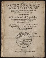
- Creator:
- Bainbridge, John, 1582-1643
- Published / Created:
- 1619
- Call Number:
- QB724 B35
- Image Count:
- 2
- Found in:
- Beinecke Rare Book and Manuscript Library > An astronomicall description of the late comet from the 18. of Nov. 1618 to the 16. of Dec. following : With certaine morall prognosticks or applications drawne from the comets motion and irradiation amongst the celestiall hieroglyphicks / By vigilant and diligent obseruations of Iohn Bainbridge
- Creator:
- Nieuhof, Johannes, 1618-1672
- Published / Created:
- 1673
- Call Number:
- 1998 Folio 71
- Image Count:
- 1
- Resource Type:
- Books, Journals & Pamphlets
- Found in:
- Beinecke Rare Book and Manuscript Library > An embassy from the East-India Company of the United Provinces, to the Grand Tartar Cham, Emperor of China : deliverd by their excellencies, Peter de Goyer and Jacob de Keyzer, at his imperial city of Peking : wherein the cities, towns, villages, ports, r
- Creator:
- Patrons of the Anniversary of the Charity-Schools (Society)
- Published / Created:
- [1824]
- Call Number:
- File 646 824 P314+
- Image Count:
- 1
- Resource Type:
- text and still image
- Found in:
- Lewis Walpole Library > Anniversary meeting of the Charity Children in the Cathedral Church of St. Paul, London [graphic].
- Creator:
- Patrons of the Anniversary of the Charity-Schools (Society)
- Published / Created:
- [1821]
- Call Number:
- File 646 821 P314+
- Image Count:
- 1
- Resource Type:
- text and still image
- Found in:
- Lewis Walpole Library > Anniversary meeting of the Charity Children in the Cathedral Church of St. Paul, London [graphic].
- Creator:
- Anville, Jean Baptiste Bourguignon d', 1697-1782
Cook, James, 1728-1779
Kitchin, Thomas, d. 1784, creator
Sayer, Robert, 1725-1794
- Published / Created:
- 1787 January 6
- Call Number:
- 1982 Folio 10
- Image Count:
- 2
- Found in:
- Beinecke Rare Book and Manuscript Library > Asia and its islands according to d'Anville : divided into empires, kingdoms, states, regions, & ca. with the European possessions and settlements in the East Indies and an exact delineation of all the discoveries made in the eastern parts by the English