
You Searched For
1 - 8 of 8
Search Results

2.
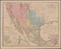
- Creator:
- Tanner, Henry Schenck, 1786-1858
- Published / Created:
- 1846
- Call Number:
- 88 1846C
- Container / Volume:
- BRBL_00645
- Image Count:
- 1
- Resource Type:
- Maps, Atlases & Globes
- Alternative Title:
- Map of the roads &c from Vera Cruz & Alvarado to Mexico., Tanner's travelling map of Mexico, and Travelling map of Mexico
- Description:
- "Entered according to act of Congress, in the year 1846, by H.S. Tanner in the clerks office of the district court for the southern district of New York.", Copy 2 without cover, mounted on linen., Includes distance and statistical tables and inset of "Map of the roads &c from Vera Cruz & Alvarado to Mexico" (scale [ca. 1:1,160,000])., Prime meridian: Washington., and Relief shown by hachures.
- Publisher:
- H.S. Tanner,
- Subject (Geographic):
- Mexico--Maps and Southwest, New--Maps
- Found in:
- Beinecke Rare Book and Manuscript Library > A map of the United States of Mexico : as organized and defined by the several acts of the Congress of that Republic / constructed from a great variety of printed and manuscript documents by H.S. Tanner.
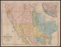
3.

- Creator:
- Tanner, Henry Schenck, 1786-1858
- Published / Created:
- 1847
- Call Number:
- 88 1847D
- Container / Volume:
- BRBL_00645
- Image Count:
- 1
- Resource Type:
- Maps, Atlases & Globes
- Alternative Title:
- Harbor of Vera Cruz., Map of the roads &c from Vera Cruz & Alvarado to Mexico., Tanner's travelling map of Mexico, and Travelling map of Mexico
- Description:
- "Entered according to act of Congress, in the year 1846, by H.S. Tanner in the clerks office of the district court for the southern district of New York.", Copy 2 mounted on linen and without cover., Includes statistical and distance tables., Insets: Map of the roads &c from Vera Cruz & Alvarado to Mexico. Scale [ca. 1:1,160,000] -- Harbor of Vera Cruz. Scale [ca. 1:72,500]., Prime meridian: Washington., and Relief shown by hachures.
- Publisher:
- H.S. Tanner,
- Subject (Geographic):
- Mexico--Maps and Southwest, New--Maps
- Found in:
- Beinecke Rare Book and Manuscript Library > A map of the United States of Mexico : as organized and defined by the several acts of the congress of that republic / constructed from a great variety of printed and manuscript documents by H.S. Tanner.
- Creator:
- Tanner, Henry Schenck, 1786-1858
- Published / Created:
- 1849
- Call Number:
- 844 1849D
- Container / Volume:
- BRBL_00601
- Image Count:
- 1
- Resource Type:
- Maps, Atlases & Globes
- Alternative Title:
- Tanner's travelling map of California &c, Travelling map of California, and United States, Mexico &c, showing the routes from N. York to St. Francisco by land & water.
- Description:
- Includes inset of "United States, Mexico &c, showing the routes from N. York to St. Francisco by land & water.", Library's copy 2 mounted on linen, without cover., Relief shown by hachures., Shows the New Southwest and parts of Texas and Mexico., and Text inside front cover, "Table of routes from New-York to California with the modes of conveyance, distances, time and fares."
- Publisher:
- H.S. Tanner,
- Subject (Geographic):
- California--Gold discoveries--Maps, California--Maps, Mexico--Maps, and Southwest, New--Maps
- Subject (Topic):
- Gold mines and mining--California--Maps
- Found in:
- Beinecke Rare Book and Manuscript Library > Map of California, New Mexico, Texas &c.
- Creator:
- Tanner, Henry Schenck, 1786-1858
- Published / Created:
- [1823]
- Call Number:
- 774 1823
- Container / Volume:
- BRBL_00498
- Image Count:
- 1
- Resource Type:
- Maps, Atlases & Globes
- Description:
- "Entered according to Act of Congress, the 20th day of August 1823, by H.S. Tanner, of the State of Pennsylvania.", In top margin: American atlas., Prime meridians: Washington and Greenwich., and Shows roads, towns, villages, mills, iron works, forts, post offic
- Publisher:
- H.S. Tanner,
- Subject (Geographic):
- New Jersey--Maps and Pennsylvania--Maps
- Subject (Name):
- Tanner, Henry Schenck, 1786-1858. New American atlas
- Found in:
- Beinecke Rare Book and Manuscript Library > Map of Pennsylvania and New Jersey / by H.S. Tanner ; engraved by H.S. Tanner & assistants.
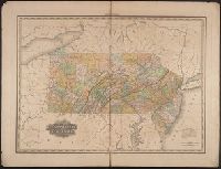
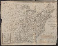
6.
- Creator:
- Tanner, Henry Schenck, 1786-1858
- Published / Created:
- 1840
- Call Number:
- 75gm 1840C
- Container / Volume:
- BRBL_00410
- Image Count:
- 1
- Resource Type:
- Maps, Atlases & Globes
- Description:
- "Entered according to Act of Congress in the year 1839, by H.S. Tanner of the state of Pennsylvania.", Canals are shown in red and yellow. Railway lines shown in blue; proposed lines in green., Copy with canals, railroads colored, and borders colored., and Inclu
- Publisher:
- T.R. Tanner & J. Disturnell,
- Subject (Geographic):
- United States--Maps.
- Subject (Name):
- Disturnell, John, 1801-1877 and Knight, J. (Jonathan), 1787-1858
- Subject (Topic):
- Canals--United States--Maps. and Railroads--United States--Maps.
- Found in:
- Beinecke Rare Book and Manuscript Library > Map of the canals & rail roads of the United States / reduced from the large map of the U.S. by H.S. Tanner ; engraved by J. Knight.
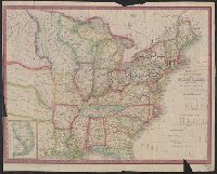
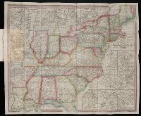
7.
- Creator:
- Tanner, Henry Schenck, 1786-1858
- Published / Created:
- 1840
- Call Number:
- 75gm 1840B
- Container / Volume:
- BRBL_00410
- Image Count:
- 1
- Resource Type:
- Maps, Atlases & Globes
- Description:
- "Entered according to Act of Congress in the year 1839, by H.S. Tanner of the state of Pennsylvania.", Canals are shown in red and yellow. Railway lines shown in blue; proposed lines in green., Copy with canals and railroads colored., and Includes 4 canal cross
- Publisher:
- T.R. Tanner & J. Disturnell,
- Subject (Geographic):
- United States--Maps.
- Subject (Name):
- Disturnell, John, 1801-1877 and Knight, J. (Jonathan), 1787-1858
- Subject (Topic):
- Canals--United States--Maps. and Railroads--United States--Maps
- Found in:
- Beinecke Rare Book and Manuscript Library > Map of the canals & rail roads of the United States / reduced from the large map of the U.S. by H.S. Tanner ; engraved by J. Knight.
8.
- Creator:
- Tanner, Henry Schenck, 1786-1858
- Published / Created:
- 1839
- Call Number:
- CE158 T35 1839
- Collection Title:
- The American traveller; or, Guide through the United States
- Image Count:
- 1
- Resource Type:
- Maps, Atlases & Globes
- Publisher:
- The author
- Collection Created:
- Philadelphia,
- Found in:
- Beinecke Rare Book and Manuscript Library > The Travellers Guide or Map of the Roads, Canals and Railroads of the United States with distances from place to place