Search
You Searched For
Search Results
- Published / Created:
- [1920?]
- Call Number:
- 515 1920
- Container / Volume:
- BRBL_00707
- Image Count:
- 13
- Resource Type:
- Maps, Atlases & Globes
- Found in:
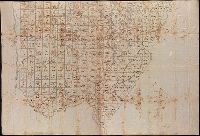
- Beinecke Rare Book and Manuscript Library > [Manuscript maps showing ruin sites etc. in the Transjordan and adjacent areas].
- Published / Created:
- [1870?]
- Call Number:
- 766 N46 1870H
- Container / Volume:
- BRBL_00712
- Image Count:
- 4
- Resource Type:
- Maps, Atlases & Globes
- Found in:
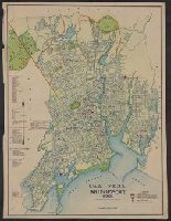
- Beinecke Rare Book and Manuscript Library > Manuscript maps of New Haven.
- Published / Created:
- 1823
- Call Number:
- 32 L9431 1823
- Container / Volume:
- BRBL_00701
- Image Count:
- 5
- Resource Type:
- Maps, Atlases & Globes
- Found in:
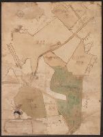
- Beinecke Rare Book and Manuscript Library > [Manuscript map of Lovell Hill, Berkshire].
- Creator:
- Bruner, L. D.
- Published / Created:
- [1867?]
- Call Number:
- BrSides Elephant Folio 2018 14
- Image Count:
- 7
- Resource Type:
- Maps, Atlases & Globes
- Found in:
- Beinecke Rare Book and Manuscript Library > [Collection of five manuscript nautical charts of the World, the South Atlantic, and the East Indies with "Course indicator of U.S.S. 'Idaho'" drawn by L.D. Bruner].
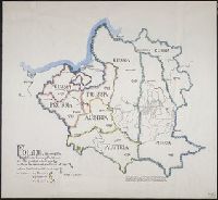
- Published / Created:
- 1939
- Call Number:
- 356fd 1939C
- Container / Volume:
- BRBL_00702
- Image Count:
- 1
- Resource Type:
- Maps, Atlases & Globes
- Found in:
- Beinecke Rare Book and Manuscript Library > Poland, showing the Eighteenth Century Partitions; at its greatest extent, 1772: before the second partition of 1793: before the third partition of 1795.
- Published / Created:
- 1837
- Call Number:
- 39hc Sa54 1837
- Container / Volume:
- BRBL_00703
- Image Count:
- 1
- Resource Type:
- Maps, Atlases & Globes
- Found in:
- Beinecke Rare Book and Manuscript Library > Plan of the Operations in Spain between the 10th and 16th of March 1837.
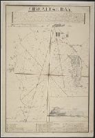
- Published / Created:
- [1800?]
- Call Number:
- 399 1800
- Container / Volume:
- BRBL_00704
- Image Count:
- 1
- Resource Type:
- Maps, Atlases & Globes
- Found in:
- Beinecke Rare Book and Manuscript Library > Gibraltar Bay.
- Published / Created:
- 1684
- Call Number:
- 18 1684
- Container / Volume:
- BRBL_00700
- Image Count:
- 1
- Resource Type:
- Maps, Atlases & Globes
- Found in:
- Beinecke Rare Book and Manuscript Library > The Northern part of ye World projected upon the Plaine of the Equator. By Anthony Payne ... A. AE 15 1/2. 1684.
- Published / Created:
- 1798
- Call Number:
- 27cea 1798
- Container / Volume:
- BRBL_00700
- Image Count:
- 1
- Resource Type:
- Maps, Atlases & Globes
- Found in:
- Beinecke Rare Book and Manuscript Library > A New Chart of the Eastern Straits or the Straits of the East of Java, with a part of the Banda Sea; corrected and improved chiefly from the observation of Captn. - Williams.
- Published / Created:
- [Between 1721 and 1724]
- Call Number:
- 352am Sa25 1721
- Container / Volume:
- BRBL_00702
- Image Count:
- 1
- Resource Type:
- Maps, Atlases & Globes
- Found in:
- Beinecke Rare Book and Manuscript Library > The E.S.E. prospective of St. Peterboug [sic] up the Goulff of Fienlad [sic] with part of the River Neva.
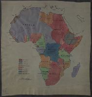
- Published / Created:
- [1915?]
- Call Number:
- 60fd 1915
- Container / Volume:
- BRBL_00707
- Image Count:
- 1
- Resource Type:
- Maps, Atlases & Globes
- Found in:
- Beinecke Rare Book and Manuscript Library > [Manuscript map of Colonial Africa].
- Creator:
- Taylor, J
- Published / Created:
- [1773]
- Call Number:
- 3254 1773
- Container / Volume:
- BRBL_00701
- Image Count:
- 1
- Resource Type:
- Maps, Atlases & Globes
- Found in:
- Beinecke Rare Book and Manuscript Library > The Kites Nest, Broadway Court, and the Home Farms belonging to Geo. Savage Esqr., in the parish of Broadway, and county of Worcester, 1773 / J. Taylor delint.
- Published / Created:
- [1780]
- Call Number:
- 29cea 1780
- Container / Volume:
- BRBL_00701
- Image Count:
- 1
- Resource Type:
- Maps, Atlases & Globes
- Found in:
- Beinecke Rare Book and Manuscript Library > A Plane Chart of several Islands Bank Shoals & Soundings ...
- Published / Created:
- [1870?]
- Call Number:
- 556 1870
- Container / Volume:
- BRBL_00707
- Image Count:
- 1
- Resource Type:
- Maps, Atlases & Globes
- Found in:
- Beinecke Rare Book and Manuscript Library > [Manuscript map of Asia and Australia.]
- Published / Created:
- [ca. 1750]
- Call Number:
- 733 B384 1750
- Container / Volume:
- BRBL_00709
- Image Count:
- 1
- Resource Type:
- Maps, Atlases & Globes
- Found in:
- Beinecke Rare Book and Manuscript Library > [Manuscript map of Fort Beauséjour, Acadia].
- Published / Created:
- [1690?]
- Call Number:
- 521 J565 1690
- Container / Volume:
- BRBL_00707
- Image Count:
- 1
- Resource Type:
- Maps, Atlases & Globes
- Found in:
- Beinecke Rare Book and Manuscript Library > [Manuscript map of the Red Sea around the town of Jiddah (or Jedda.)].
- Published / Created:
- [1800?]
- Call Number:
- 399cea 1800
- Container / Volume:
- BRBL_00704
- Image Count:
- 1
- Resource Type:
- Maps, Atlases & Globes
- Found in:
- Beinecke Rare Book and Manuscript Library > Plan of Gibraltar Bay.
- Published / Created:
- [1715?]
- Call Number:
- 53 1700
- Container / Volume:
- BRBL_00707
- Image Count:
- 1
- Resource Type:
- Maps, Atlases & Globes
- Found in:
- Beinecke Rare Book and Manuscript Library > A large draught of the Red Sea from Mount Felix to Judda.
- Published / Created:
- 1828
- Call Number:
- 75 1828D
- Container / Volume:
- BRBL_00709
- Image Count:
- 1
- Resource Type:
- Maps, Atlases & Globes
- Found in:
- Beinecke Rare Book and Manuscript Library > A Map of the United States. Projected by Nancy Gibbs, Livermore, 1828.
- Published / Created:
- [1837]
- Call Number:
- 394hc 1837
- Container / Volume:
- BRBL_00703
- Image Count:
- 1
- Resource Type:
- Maps, Atlases & Globes
- Found in:
- Beinecke Rare Book and Manuscript Library > [Manuscript map of Passages, Spain].
- Published / Created:
- [1929?]
- Call Number:
- 632 K129 1929
- Container / Volume:
- BRBL_00708
- Image Count:
- 1
- Resource Type:
- Maps, Atlases & Globes
- Found in:
- Beinecke Rare Book and Manuscript Library > Map of Kampala showing collecting stations of water ...
- Published / Created:
- [1846?]
- Call Number:
- 54635 K836 1846
- Container / Volume:
- BRBL_00707
- Image Count:
- 1
- Resource Type:
- Maps, Atlases & Globes
- Found in:
- Beinecke Rare Book and Manuscript Library > [Manuscript map showing part of the Bering Island or Komandor Islands and the position of the wreck of the ship "Baltic" out of New Bedford].
- Published / Created:
- 1738
- Call Number:
- 583 1738
- Container / Volume:
- BRBL_00707
- Image Count:
- 1
- Resource Type:
- Maps, Atlases & Globes
- Found in:
- Beinecke Rare Book and Manuscript Library > Part of Malaya. Part of Tanasary.
- Published / Created:
- [187-?]
- Call Number:
- 582 B22 187X
- Container / Volume:
- BRBL_00707
- Image Count:
- 1
- Resource Type:
- Maps, Atlases & Globes
- Found in:
- Beinecke Rare Book and Manuscript Library > [Thailand, from Bangkok west to Phet Buri].
- Published / Created:
- 1785
- Call Number:
- 648cea Sa23 1785
- Container / Volume:
- BRBL_00708
- Image Count:
- 1
- Resource Type:
- Maps, Atlases & Globes
- Found in:
- Beinecke Rare Book and Manuscript Library > A chart of a bay [St. Francis Bay?] on the SE coast of Africa ... 1785 ... in Lat. 34°09'S, Long 26°10'E.
- Published / Created:
- [1798]
- Call Number:
- 734 B797 1798
- Container / Volume:
- BRBL_00709
- Image Count:
- 1
- Resource Type:
- Maps, Atlases & Globes
- Found in:
- Beinecke Rare Book and Manuscript Library > Plan of the Township of Broughton surveyed by Order of Samuel Holland Esq. Surveyor General of Lower and Upper Canada. By Christopher S. Bailley, Dept. Provinl. Surr.
- Published / Created:
- [1700?]
- Call Number:
- 761 1700
- Container / Volume:
- BRBL_00709
- Image Count:
- 1
- Resource Type:
- Maps, Atlases & Globes
- Found in:
- Beinecke Rare Book and Manuscript Library > [Manuscript map of the Maine Coastline].
- Creator:
- Paucker, Fred
- Published / Created:
- 1957
- Call Number:
- 51 1957
- Image Count:
- 1
- Resource Type:
- Maps, Atlases & Globes
- Found in:
- Beinecke Rare Book and Manuscript Library > [Map of Israel] / Fred Paucker.
- Creator:
- Johnson, Thomas H., Cartographer
- Published / Created:
- 2nd Feby. 1877.
- Call Number:
- BrSides Double Folio 2018 97
- Image Count:
- 1
- Resource Type:
- Maps, Atlases & Globes
- Found in:
- Beinecke Rare Book and Manuscript Library > McIntyre / Thos. H. Johnson, Assistant Commissioner.
- Creator:
- Heyrick, J. C., creator
- Published / Created:
- 1912
- Call Number:
- 802gbc P429 1912
- Container / Volume:
- BRBL_00717
- Image Count:
- 1
- Resource Type:
- Maps, Atlases & Globes
- Found in:
- Beinecke Rare Book and Manuscript Library > Map of Riverside Coal & Timber Co. : lands on Little Leatherwood C'r, Perry Co., Kentucky / J.C. Heydrick.
- Creator:
- Heart, Jonathan, 1748-1791
- Published / Created:
- 1787
- Call Number:
- 774 F854 1787A
- Container / Volume:
- BRBL_00730
- Image Count:
- 1
- Resource Type:
- Maps, Atlases & Globes
- Found in:
- Beinecke Rare Book and Manuscript Library > Profile of the works on French Creek [cartographic material].
- Creator:
- Heart, Jonathan, 1748-1791
- Published / Created:
- 1787
- Call Number:
- 774 F854 1787
- Container / Volume:
- BRBL_00730
- Image Count:
- 1
- Resource Type:
- Maps, Atlases & Globes
- Found in:
- Beinecke Rare Book and Manuscript Library > Map of the country adjacent to Fort [Franklin] on French Creek / by Jona. Heart ...
- Published / Created:
- [between 1875 and 1900?]
- Call Number:
- BrSides 2018 155
- Image Count:
- 1
- Resource Type:
- Maps, Atlases & Globes
- Found in:
- Beinecke Rare Book and Manuscript Library > [Manuscript map of mine locations in Michigan].
- Published / Created:
- [between 1850 and 1859?]
- Call Number:
- BrSides 2018 156
- Image Count:
- 1
- Resource Type:
- Maps, Atlases & Globes
- Found in:
- Beinecke Rare Book and Manuscript Library > Map showing copper lands in Virginia.
- Published / Created:
- [between 1875 and 1900?]
- Call Number:
- BrSides Folio 2018 133
- Image Count:
- 1
- Resource Type:
- Maps, Atlases & Globes
- Found in:
- Beinecke Rare Book and Manuscript Library > [Manuscript map of delineations of unknown property owned by Richard H. Rickard].
- Published / Created:
- [1872?]
- Call Number:
- BrSides Folio 2018 139
- Image Count:
- 1
- Resource Type:
- Maps, Atlases & Globes
- Found in:
- Beinecke Rare Book and Manuscript Library > [Map of Thunder Bay District, Canada, showing silver lands owned by Peter Mitchell & others, Sept. 7th, 1872].
- Creator:
- Denton, D. S., Jr., cartographer.
- Published / Created:
- [1907]
- Call Number:
- BrSides Double Folio 2018 88
- Image Count:
- 1
- Resource Type:
- Maps, Atlases & Globes
- Found in:
- Beinecke Rare Book and Manuscript Library > Map of Meadow Land at Ocean side in the town of Hempstead Nassau County, N.Y. belonging to the estate of Lewis Davison Dec'd and the estate of Tredwell Davison dec'd / surveyed in March 1907, by DS Denton, Jr.
- Published / Created:
- [between 1875 and 1900?]
- Call Number:
- BrSides Box 2018 74
- Image Count:
- 1
- Resource Type:
- Maps, Atlases & Globes
- Found in:
- Beinecke Rare Book and Manuscript Library > [Manuscript map of mine locations in the vicinity of Mass City, Michigan].
- Published / Created:
- [ca. 1745]
- Call Number:
- 7325cea L93 1745A
- Container / Volume:
- BRBL_00709
- Image Count:
- 1
- Resource Type:
- Maps, Atlases & Globes
- Found in:
- Beinecke Rare Book and Manuscript Library > Plan of the harbour and fortifications of Louisbourg. The harbour survey'd by Capt. Phi: Durell; the town by Iohn Henry Bastide Engineer for Nova Scotia.
- Published / Created:
- [1745]
- Call Number:
- 732cea C16 1745
- Container / Volume:
- BRBL_00709
- Image Count:
- 1
- Resource Type:
- Maps, Atlases & Globes
- Found in:
- Beinecke Rare Book and Manuscript Library > [Manuscript map of the Gut of Canse].
- Published / Created:
- 1762
- Call Number:
- 72cea Sa23 1762
- Container / Volume:
- BRBL_00708
- Image Count:
- 1
- Resource Type:
- Maps, Atlases & Globes
- Found in:
- Beinecke Rare Book and Manuscript Library > View of the Land and Plan of the harbour of St. Johns in the Island of Newfoundland, North America.
- Published / Created:
- [1840?].
- Call Number:
- 764 B77 1740
- Container / Volume:
- BRBL_00710
- Image Count:
- 1
- Resource Type:
- Maps, Atlases & Globes
- Found in:
- Beinecke Rare Book and Manuscript Library > A Map of Brimfield as it was from its settlement 1720 till 1740. [Rev.] J[ason] Morse.
- Published / Created:
- 1741
- Call Number:
- 764 M92 1741
- Container / Volume:
- BRBL_00710
- Image Count:
- 1
- Resource Type:
- Maps, Atlases & Globes
- Found in:
- Beinecke Rare Book and Manuscript Library > Plan of Munjoy's Neck.
- Published / Created:
- 1747
- Call Number:
- 764 W52 1747
- Container / Volume:
- BRBL_00710
- Image Count:
- 1
- Resource Type:
- Maps, Atlases & Globes
- Found in:
- Beinecke Rare Book and Manuscript Library > An exact plan of Westborough South Precinct ... protracted and laid down by a scale of 200 perch for an inch by Hesebiah Ward, Surveyor.
- Published / Created:
- 1714
- Call Number:
- 732 F963 1714
- Container / Volume:
- BRBL_00708
- Image Count:
- 1
- Resource Type:
- Maps, Atlases & Globes
- Found in:
- Beinecke Rare Book and Manuscript Library > A Draft of the Bay of Fundy by John Wells.
- Published / Created:
- [ca. 1758]
- Call Number:
- 732cea 1758
- Container / Volume:
- BRBL_00709
- Image Count:
- 1
- Resource Type:
- Maps, Atlases & Globes
- Found in:
- Beinecke Rare Book and Manuscript Library > A chart of the peninsula of Nova Scotia by Charles Morris.
- Published / Created:
- 1711
- Call Number:
- 764 B65 1711
- Container / Volume:
- BRBL_00710
- Image Count:
- 1
- Resource Type:
- Maps, Atlases & Globes
- Found in:
- Beinecke Rare Book and Manuscript Library > A New plan of the Harbour of Boston in New England. Lat. 42, 29 North. Long. 71 West. Surveyed by Order of the Commissioners of her Majesty's Navy.
- Published / Created:
- 1789
- Call Number:
- 761 St24 1789
- Container / Volume:
- BRBL_00710
- Image Count:
- 1
- Resource Type:
- Maps, Atlases & Globes
- Found in:
- Beinecke Rare Book and Manuscript Library > A plan of Pearsontonn [i.e. Standish Township] planned by ... Ephraim Jones Surveyor. Falmonth, Sept. 26, 1775. Copied August 28th, 1789 (by) Saml. Freeman.
- Published / Created:
- 1764
- Call Number:
- 764 1764
- Container / Volume:
- BRBL_00710
- Image Count:
- 1
- Resource Type:
- Maps, Atlases & Globes
- Found in:
- Beinecke Rare Book and Manuscript Library > [Manuscript map of the Western boundaries of Massachusetts] sworn this line has bin measured this year 1764 ... a true copy N. Dwight. Saml. Messinger surveyor.
- Published / Created:
- [1750?]
- Call Number:
- 763fb Su87 1750
- Container / Volume:
- BRBL_00710
- Image Count:
- 1
- Resource Type:
- Maps, Atlases & Globes
- Found in:
- Beinecke Rare Book and Manuscript Library > A Sketch of the Township of Sutton, lately Billymead, showing the number of the lot and to which propietor each lot is rett.
- Published / Created:
- 1822
- Call Number:
- 761 R453 1822
- Container / Volume:
- BRBL_00710
- Image Count:
- 1
- Resource Type:
- Maps, Atlases & Globes
- Found in:
- Beinecke Rare Book and Manuscript Library > Plan of the Township of Ketcham now Riley Lying in the county of Oxford and District (State) of Maine ... by Jas Finlayson.
- Published / Created:
- ca. 1705]
- Call Number:
- 732cea C413 1705
- Container / Volume:
- BRBL_00709
- Image Count:
- 1
- Resource Type:
- Maps, Atlases & Globes
- Found in:
- Beinecke Rare Book and Manuscript Library > A draught of Southacks Bay in America [cartographic material].
- Published / Created:
- [1804?]
- Call Number:
- 764 B65 1804
- Container / Volume:
- BRBL_00710
- Image Count:
- 1
- Resource Type:
- Maps, Atlases & Globes
- Found in:
- Beinecke Rare Book and Manuscript Library > Plan of Boston Harbor, from actual survey.
- Published / Created:
- 1753
- Call Number:
- 764 G297 1753
- Container / Volume:
- BRBL_00710
- Image Count:
- 1
- Resource Type:
- Maps, Atlases & Globes
- Found in:
- Beinecke Rare Book and Manuscript Library > Plan of George's Island [in Boston Harbor].
- Published / Created:
- 1821
- Call Number:
- 764 W688 1821
- Container / Volume:
- BRBL_00710
- Image Count:
- 1
- Resource Type:
- Maps, Atlases & Globes
- Found in:
- Beinecke Rare Book and Manuscript Library > A Plan of Wilmington Taken October 1821 by Edmund Parker.
- Published / Created:
- 1757
- Call Number:
- 732 An73 1757
- Container / Volume:
- BRBL_00708
- Image Count:
- 1
- Resource Type:
- Maps, Atlases & Globes
- Found in:
- Beinecke Rare Book and Manuscript Library > Annapolis-Royal with the adjacent country 1757.
- Published / Created:
- [175-?]
- Call Number:
- 732 1750
- Container / Volume:
- BRBL_00708
- Image Count:
- 1
- Resource Type:
- Maps, Atlases & Globes
- Found in:
- Beinecke Rare Book and Manuscript Library > A Map of the surueyed parts of Noua Scotia.
- Creator:
- Morris, Charles, fl. 1749, cartographer
- Published / Created:
- 1751
- Call Number:
- 732 H13 1751
- Container / Volume:
- BRBL_00708
- Image Count:
- 1
- Resource Type:
- Maps, Atlases & Globes
- Found in:
- Beinecke Rare Book and Manuscript Library > A plan of the harbour of Halifax / by Charles Morris, chf. surveyr.
- Published / Created:
- [ca. 1746]
- Call Number:
- 7325 L93 1746
- Container / Volume:
- BRBL_00709
- Image Count:
- 1
- Resource Type:
- Maps, Atlases & Globes
- Found in:
- Beinecke Rare Book and Manuscript Library > A plan of Louisbourg intended only to shew by strong red the publick buildings lately erected, and by faint red such as have had a thorough repair. I.H. Bastide.
- Published / Created:
- [ca. 1800]
- Call Number:
- 70 1800
- Container / Volume:
- BRBL_00708
- Image Count:
- 1
- Resource Type:
- Maps, Atlases & Globes
- Found in:
- Beinecke Rare Book and Manuscript Library > Map of North and South America; John Wood.
- Published / Created:
- 1745
- Call Number:
- 7325cea L93 1745
- Container / Volume:
- BRBL_00709
- Image Count:
- 1
- Resource Type:
- Maps, Atlases & Globes
- Found in:
- Beinecke Rare Book and Manuscript Library > A Plan of the Harbour and Fortifications of Louisburg. The Harbour Survey'd by Capt. Phil: Durell. The fortifications by Capt. Will: Henry Bastide. Anne. 1745.
- Published / Created:
- 1758
- Call Number:
- 7325 L93 1758A
- Container / Volume:
- BRBL_00709
- Image Count:
- 1
- Resource Type:
- Maps, Atlases & Globes
- Found in:
- Beinecke Rare Book and Manuscript Library > A Plan of the Town and Harbour of Louisburg ... 1758. By Lieut. Joseph Norwood.
- Published / Created:
- 1745
- Call Number:
- 7325 L93 1745
- Container / Volume:
- BRBL_00709
- Image Count:
- 1
- Resource Type:
- Maps, Atlases & Globes
- Found in:
- Beinecke Rare Book and Manuscript Library > Plan of Louisbourg. Surrendered to his Britanick Majesty by capitulation the 17th of June 1745 to Lieut. General Pepperel and Commodore Warren ... drawn on the spot by John Henry Bastide.
- Creator:
- Russell, Andrew, Cartographer
- Published / Created:
- 1861
- Call Number:
- BrSides Folio 2018 140
- Image Count:
- 1
- Resource Type:
- Maps, Atlases & Globes
- Found in:
- Beinecke Rare Book and Manuscript Library > Copy of part of P.L.S. Salter's plan shewing mineral locations at and near Mamainse with a projection shewing Montreal Mining Company's location / Andrew Russell, Assistant Commissioner.
- Published / Created:
- [1872?]
- Call Number:
- BrSides Folio 2018 141
- Image Count:
- 1
- Resource Type:
- Maps, Atlases & Globes
- Found in:
- Beinecke Rare Book and Manuscript Library > [Manuscript cadastral map of mine veins in Thunder Bay District, Canada].
- Published / Created:
- [after 1842]
- Call Number:
- BrSides Elephant Folio 2018 19
- Image Count:
- 1
- Resource Type:
- Maps, Atlases & Globes
- Found in:
- Beinecke Rare Book and Manuscript Library > [Manuscript map of the northern third of Maine].
- Published / Created:
- [1935?]
- Call Number:
- 766 B76 1935
- Container / Volume:
- BRBL_00711
- Image Count:
- 1
- Resource Type:
- Maps, Atlases & Globes
- Found in:
- Beinecke Rare Book and Manuscript Library > C.W.A. - F.E.R.A., Bridgeport Conn. Prepared from Official records. [Drawn by G.W. Carmalt].
- Published / Created:
- April 1759.
- Call Number:
- 773 C884 1759
- Container / Volume:
- BRBL_00714
- Image Count:
- 1
- Resource Type:
- Maps, Atlases & Globes
- Found in:
- Beinecke Rare Book and Manuscript Library > A map of Isaac Cowgill's plantation : contain two hundred & seven acres and twenty perches / by Jno. Oliver.
- Published / Created:
- 1774
- Call Number:
- 771 1774
- Container / Volume:
- BRBL_00713
- Image Count:
- 1
- Resource Type:
- Maps, Atlases & Globes
- Found in:
- Beinecke Rare Book and Manuscript Library > A Map of the Province of New York as divided into Counties together with the adjacent provinces. Compiled from the latest Maps and Actual Surveys. Will:Cockburn.
- Published / Created:
- 1665
- Call Number:
- 764ad D728 1665
- Container / Volume:
- BRBL_00711
- Image Count:
- 1
- Resource Type:
- Maps, Atlases & Globes
- Found in:
- Beinecke Rare Book and Manuscript Library > [Manuscript map of Dorchester, Massachusetts] ... by me, Joshua Fisher, 1665.
- Published / Created:
- 1661
- Call Number:
- 764ad D728 1661
- Container / Volume:
- BRBL_00711
- Image Count:
- 1
- Resource Type:
- Maps, Atlases & Globes
- Found in:
- Beinecke Rare Book and Manuscript Library > [Manuscript map of Dorchester, Massachusetts].
- Published / Created:
- 1776
- Call Number:
- 771hc 1776
- Container / Volume:
- BRBL_00714
- Image Count:
- 1
- Resource Type:
- Maps, Atlases & Globes
- Found in:
- Beinecke Rare Book and Manuscript Library > Plan of the Operations of the British army in North America, Commanded by General Howe from the 15th to the 16th Nov. 1776.
- Published / Created:
- [1847]
- Call Number:
- 766 N46 1847
- Container / Volume:
- BRBL_00712
- Image Count:
- 1
- Resource Type:
- Maps, Atlases & Globes
- Found in:
- Beinecke Rare Book and Manuscript Library > Map of the city of New Haven.
- Published / Created:
- [1881?]
- Call Number:
- 766 N46 1724A
- Image Count:
- 1
- Resource Type:
- Maps, Atlases & Globes
- Found in:
- Beinecke Rare Book and Manuscript Library > Map of New Haven / drawn by Joseph Brown, 1724 ; copied by Prest. Ezra Stiles, 1782.
- Published / Created:
- [1881]
- Call Number:
- 766 N46 1724
- Container / Volume:
- BRBL_00712
- Image Count:
- 1
- Resource Type:
- Maps, Atlases & Globes
- Found in:
- Beinecke Rare Book and Manuscript Library > Map of New Haven / drawn by Joseph Brown, 1724 ; copied by Prest. Ezra Stiles, 1782.
- Published / Created:
- [between 1790 and 1799?]
- Call Number:
- BrSides Folio 2017 123
- Image Count:
- 1
- Resource Type:
- Maps, Atlases & Globes
- Found in:
- Beinecke Rare Book and Manuscript Library > [Map of the confluence of Saint Marys and Amelia Rivers on the border between Georgia and Florida].
- Call Number:
- BrSides Double Folio 2017 26
- Image Count:
- 1
- Resource Type:
- Maps, Atlases & Globes
- Found in:
- Beinecke Rare Book and Manuscript Library > New Haven in 1641.
- Published / Created:
- [1848?]
- Call Number:
- Small Manuscript 766 N46 1848
- Image Count:
- 4
- Resource Type:
- Maps, Atlases & Globes
- Found in:
- Beinecke Rare Book and Manuscript Library > [Map of the Nine Squares of New Haven, showing dimensions].
- Creator:
- Trumbull, John, 1756-1843, creator.
- Published / Created:
- 1776 August
- Call Number:
- BrSides Folio 2015 13
- Image Count:
- 4
- Resource Type:
- Maps, Atlases & Globes
- Found in:
- Beinecke Rare Book and Manuscript Library > Plan of Mount Independence.
- Published / Created:
- [1916?].
- Call Number:
- 11hc 1916B
- Container / Volume:
- BRBL_00010C
- Image Count:
- 2
- Resource Type:
- Maps, Atlases & Globes
- Found in:
- Beinecke Rare Book and Manuscript Library > [Country between Paris and Strassbourg.]
- Published / Created:
- [1791]
- Call Number:
- BrSides 2017 122
- Image Count:
- 2
- Resource Type:
- Maps, Atlases & Globes
- Found in:
- Beinecke Rare Book and Manuscript Library > Map of the western territory, 1791.
- Published / Created:
- [1789]
- Call Number:
- BrSides 2017 121
- Image Count:
- 2
- Resource Type:
- Maps, Atlases & Globes
- Found in:
- Beinecke Rare Book and Manuscript Library > A map of lands purchased of the state of Georgia in 1789, by the South Carolina Yazou Company, by the Virginia Yazou Company, and by the Tennessee Company / sketched from a map of Zachariah Coxe's Esq., who made it from an actual survey of these counties; this draught, although coarsely done, is exact, and consonant the scale adopted by the said Coxe.
- Published / Created:
- 1758
- Call Number:
- 36hc Sa56 1758
- Container / Volume:
- BRBL_00703
- Image Count:
- 2
- Resource Type:
- Maps, Atlases & Globes
- Found in:
- Beinecke Rare Book and Manuscript Library > Plan of the Battle of Sandershausen near Cassell ... 1758 ... Allied Army ... Vanguard of the French Army ...
- Published / Created:
- [1886]
- Call Number:
- 60 1886
- Container / Volume:
- BRBL_00707
- Image Count:
- 2
- Resource Type:
- Maps, Atlases & Globes
- Found in:
- Beinecke Rare Book and Manuscript Library > Equatorial Africa.
- Published / Created:
- [1776?]
- Call Number:
- 755 1776M
- Container / Volume:
- BRBL_00709
- Image Count:
- 2
- Resource Type:
- Maps, Atlases & Globes
- Found in:
- Beinecke Rare Book and Manuscript Library > View of the different passes into Canada.
- Creator:
- Kirkwood, James Pugh, 1807-1877
- Published / Created:
- [1847]
- Call Number:
- 766 N46 1847A
- Container / Volume:
- BRBL_00712
- Image Count:
- 2
- Resource Type:
- Maps, Atlases & Globes
- Found in:
- Beinecke Rare Book and Manuscript Library > Experimental survey for a railroad between New Haven & Humphreysville, forming part of the line to Waterbury / made in July 1847 by J.P. Kirkwood.
- Creator:
- Giddings, Amelia
- Published / Created:
- 1815
- Call Number:
- BrSides Double Folio 2019 3
- Image Count:
- 2
- Resource Type:
- Maps, Atlases & Globes
- Found in:
- Beinecke Rare Book and Manuscript Library > Map of England / Amelia Giddings aged 9 years.
- Creator:
- Comberford, Nicholas, -1673, cartographer.
- Published / Created:
- [1647]
- Call Number:
- 49 1647
- Image Count:
- 2
- Resource Type:
- Maps, Atlases & Globes
- Found in:
- Beinecke Rare Book and Manuscript Library > Portolan chart of the Mediterranean Sea, the Black Sea, and the northern coast of Africa.
- Published / Created:
- [ca. 1789]
- Call Number:
- 6555cea 1789
- Container / Volume:
- BRBL_00708
- Image Count:
- 3
- Resource Type:
- Maps, Atlases & Globes
- Found in:
- Beinecke Rare Book and Manuscript Library > A New Survey of that part of the Coast of Africa comprised between Cape Verga and Cape Formoso, including chiefly the Windward and Gold Coasts in which the Latitudes of all the Principal Places are determined by Actual observations, the bearings and cours
- Published / Created:
- 1824
- Call Number:
- 761 B41 1824
- Container / Volume:
- BRBL_00710
- Image Count:
- 3
- Resource Type:
- Maps, Atlases & Globes
- Found in:
- Beinecke Rare Book and Manuscript Library > [Manuscript map of part of Belfast, Maine by George Watson].
- Published / Created:
- 1953?]
- Call Number:
- 11hcf 1919A-4
- Container / Volume:
- BRBL_00010N
- Image Count:
- 1
- Resource Type:
- Maps, Atlases & Globes
- Found in:
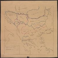
- Beinecke Rare Book and Manuscript Library > Small sketch map of Poland probably drawn by R.J. Kerner to illustrate hastily proposed Czech-Jugoslav Corridor.
- Published / Created:
- 1919?]
- Call Number:
- 11hcf 1919C-1-3
- Container / Volume:
- BRBL_00010S
- Image Count:
- 1
- Resource Type:
- Maps, Atlases & Globes
- Found in:
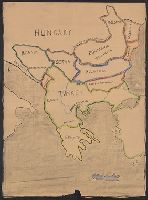
- Beinecke Rare Book and Manuscript Library > [Manuscript map of the Balkan Peninsula].
- Published / Created:
- 1878?]
- Call Number:
- 11hcf 1919C-1-1
- Container / Volume:
- BRBL_00010S
- Image Count:
- 1
- Resource Type:
- Maps, Atlases & Globes
- Found in:
- Beinecke Rare Book and Manuscript Library > [Manuscript Map showing boundaries according to the Treaty of Berlin and the Treaty of San Stefano].
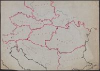
- Published / Created:
- 1919?]
- Call Number:
- 11hcf 1919C-3-13
- Container / Volume:
- BRBL_00010U
- Image Count:
- 1
- Resource Type:
- Maps, Atlases & Globes
- Found in:
- Beinecke Rare Book and Manuscript Library > [Manuscript map of Balkan Peninsula and Eastern Europe].
- Published / Created:
- 1919?]
- Call Number:
- 11hcf 1919C-3-15
- Container / Volume:
- BRBL_00010U
- Image Count:
- 1
- Resource Type:
- Maps, Atlases & Globes
- Found in:
- Beinecke Rare Book and Manuscript Library > [Manuscript map of Balkan Peninsula and Eastern Europe].
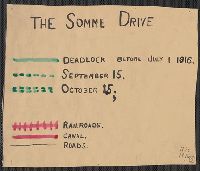
- Published / Created:
- 1916
- Call Number:
- 11hc 1916
- Container / Volume:
- BRBL_00010C
- Image Count:
- 1
- Resource Type:
- Maps, Atlases & Globes
- Found in:
- Beinecke Rare Book and Manuscript Library > [The Somme Drive.]
- Creator:
- Conrad, Joseph, 1857-1924
- Published / Created:
- [1910?]
- Call Number:
- 652 1910
- Container / Volume:
- BRBL_00342
- Image Count:
- 1
- Resource Type:
- Maps, Atlases & Globes
- Found in:
- Beinecke Rare Book and Manuscript Library > Map of Congo Basin : showing path traveled by Joseph Conrad Korzeniowski.