Search
You Searched For
Search Results
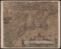
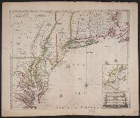
- Creator:
- Robert Sayer and John Bennett (Firm)
- Call Number:
- 755 1776K
- Container / Volume:
- BRBL_00430
- Image Count:
- 1
- Resource Type:
- Maps, Atlases & Globes
- Alternative Title:
- , Nova-Scotia, New-England, New-York, New
- Subject (Geographic):
- New England--Maps--Early works to 1800
- Found in:
- Beinecke Rare Book and Manuscript Library > A general map of the northern British colonies in America : which comprehends the province of Quebec, the government of Newfoundland, Nova-Scotia, New-England and New-York, from the maps published by the Admiralty and Board of Trade, regulated by the astr
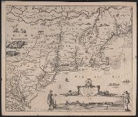
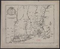
- Creator:
- Robert Sayer and John Bennett (Firm)
- Call Number:
- 755 1776G
- Container / Volume:
- BRBL_00430
- Image Count:
- 1
- Resource Type:
- Maps, Atlases & Globes
- Alternative Title:
- , Nova-Scotia, New-England, New-York, New
- Description:
- B.B. McCorkle, New England in early
- Subject (Geographic):
- New England--Maps--Early works to 1800
- Found in:
- Beinecke Rare Book and Manuscript Library > A general map of the Northern British Colonies in America, which comprehends the Province of Quebec, the government of Newfoundland, Nova-Scotia, New-England and New York : from the surveys of Capt. Cook & Capt. Carver, regulated by the astronomic & trigo
- Creator:
- Rhode, Johann Christoph, cartographer
- Call Number:
- 755 1755AA
- Container / Volume:
- BRBL_00427
- Image Count:
- 1
- Resource Type:
- Maps, Atlases & Globes
- Description:
- , Early printed maps of New England 1513-1800
- Found in:
- Beinecke Rare Book and Manuscript Library > Theatrum belli in America Septentrionali / II. foliis comprehensum jussu Acad. Reg. Scient. et Eleg. Litt. exhibet I. C. Rhode Ac: Geogr. ; Berger, sculpsit berol.
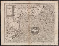
- Creator:
- Wytfliet, Corneille
- Published / Created:
- 1597
- Call Number:
- 755 1597
- Container / Volume:
- BRBL_00728
- Image Count:
- 1
- Resource Type:
- Maps, Atlases & Globes
- Found in:
- Beinecke Rare Book and Manuscript Library > Norumbega et Virginia, 1597 [cartographic material].
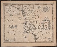
- Creator:
- Quad, Matthias, 1557-1613
- Published / Created:
- between 1600 and 1608]
- Call Number:
- 71 1600
- Container / Volume:
- BRBL_00687
- Image Count:
- 2
- Resource Type:
- Maps, Atlases & Globes
- Description:
- placed in New England area, and a peninsula
- Found in:
- Beinecke Rare Book and Manuscript Library > Novi orbis pars borealis, America scilicet complectens Floridam, Baccalaon, Canadam, terram Corterialem, Virginiam, Norombecam, pluresque alias provincias.
- Creator:
- Blaeu, Willem Janszoon, 1571-1638
- Published / Created:
- 163-?]
- Call Number:
- 755 1635
- Container / Volume:
- BRBL_00422
- Image Count:
- 1
- Resource Type:
- Maps, Atlases & Globes
- Subject (Geographic):
- New England--Maps--Early works to 1800
- Found in:
- Beinecke Rare Book and Manuscript Library > Nova Belgica et Anglia Nova.
- Creator:
- Visscher, Nicolaes, 1618-1679
- Published / Created:
- 1655?]
- Call Number:
- 75 1655
- Container / Volume:
- BRBL_00689
- Image Count:
- 1
- Resource Type:
- Maps, Atlases & Globes
- Subject (Geographic):
- New England--Maps--Early works to 1800
- Found in:
- Beinecke Rare Book and Manuscript Library > Novi Belgii, Novaeque Angliae nec non partis Virginiae tabula / [cartographic material] / multis in locis emendata a Nicolao Joannis Visschero.
- Creator:
- Visscher, Nicolaes, 1618-1679
- Published / Created:
- 1655?]
- Call Number:
- 755 1655
- Container / Volume:
- BRBL_00423
- Image Count:
- 1
- Resource Type:
- Maps, Atlases & Globes
- Subject (Geographic):
- New England--Maps--Early works to 1800
- Found in:
- Beinecke Rare Book and Manuscript Library > Novi Belgii, Novaeque Angliae nec non partis Virginiae tabula / [cartographic material] / multis in locis emendata a Nicolao Joannis Visschero.
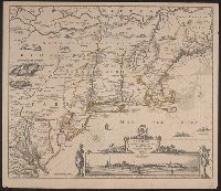
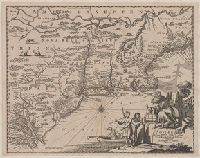
- Creator:
- Montanus, Arnoldus, 1625?-1683
- Published / Created:
- 1671?]
- Call Number:
- 755 1671B
- Container / Volume:
- BRBL_00680
- Image Count:
- 1
- Resource Type:
- Maps, Atlases & Globes
- Subject (Geographic):
- New England--Maps--Early works to 1800
- Found in:
- Beinecke Rare Book and Manuscript Library > Novi Belgii, quod nunc Novi Jorck vocatur, Novae q[ue] Angliae & partis Virginiae : accuratissima et novissima delineatio.
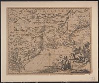
- Creator:
- Montanus, Arnoldus, 1625?-1683
- Published / Created:
- 1671?]
- Call Number:
- 755 1671B
- Container / Volume:
- BRBL_00423
- Image Count:
- 1
- Resource Type:
- Maps, Atlases & Globes
- Subject (Geographic):
- New England--Maps--Early works to 1800
- Found in:
- Beinecke Rare Book and Manuscript Library > Novi Belgii, quod nunc Novi Jorck vocatur, Novae q[ue] Angliae & partis Virginiae : accuratissima et novissima delineatio.
- Creator:
- Thornton, John, fl. 1652-1701
- Published / Created:
- [1673?]
- Call Number:
- 755 1682B
- Container / Volume:
- BRBL_00424
- Image Count:
- 1
- Resource Type:
- Maps, Atlases & Globes
- Alternative Title:
- , New-York & New England
- Description:
- Inset: "A mapp of New England".
- Subject (Geographic):
- New England--Maps--Early works to 1800
- Found in:
- Beinecke Rare Book and Manuscript Library > A mapp of Virginia, Mary-land, New-Jarsey, New-York, & New England.
- Creator:
- Thornton, John, fl. 1652-1701
- Published / Created:
- [ca. 1673?]
- Call Number:
- 71 1673
- Container / Volume:
- BRBL_00360
- Image Count:
- 1
- Resource Type:
- Maps, Atlases & Globes
- Found in:
- Beinecke Rare Book and Manuscript Library > A new mapp of the north part of America : from Hudson Straights commanly call'd the Norwest Passage, including Newfoundland, New Scotland, New England, Virginia, Maryland & Carolena / made and sold by John Thornton at the signe of England, Scotland & Irel
- Creator:
- Seller, John, fl. 1658-1698
- Published / Created:
- [1675]
- Call Number:
- 76 1675
- Image Count:
- 1
- Resource Type:
- Maps, Atlases & Globes
- Description:
- : A description of New-England (4 p. ; 46
- Subject (Geographic):
- New England--Maps--Early works to 1800
- Found in:
- Beinecke Rare Book and Manuscript Library > A mapp of New England / by John Seller, hydrographer to the King.
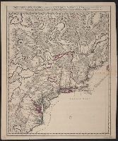
- Published / Created:
- [1675?]
- Call Number:
- 755 1675A
- Container / Volume:
- BRBL_00423
- Image Count:
- 1
- Resource Type:
- Maps, Atlases & Globes
- Subject (Geographic):
- New England--Maps--Early works to 1800
- Found in:
- Beinecke Rare Book and Manuscript Library > Nova tabula geographica complectens Borealiorem Americæ partem ... / Luggardus van Anse schulp.
- Creator:
- Morden, Robert, d. 1703
- Published / Created:
- [1676?]
- Call Number:
- 755 1675E
- Container / Volume:
- BRBL_00423
- Image Count:
- 1
- Resource Type:
- Maps, Atlases & Globes
- Alternative Title:
- Map of New England, New Yorke, New
- Subject (Geographic):
- New England--Maps--Early works to 1800
- Found in:
- Beinecke Rare Book and Manuscript Library > A map of New England, New Yorke, New Jersey, Mary-land & Virginia / Gr. King sculpsit.
- Creator:
- Speed, John, 1552?-1629
- Published / Created:
- [1676]
- Call Number:
- 755 1672A
- Container / Volume:
- BRBL_00423
- Image Count:
- 2
- Resource Type:
- Maps, Atlases & Globes
- Subject (Geographic):
- New England--Maps--Early works to 1800
- Found in:
- Beinecke Rare Book and Manuscript Library > A map of New England and New York / F. Lamb sculp.
- Published / Created:
- [1690?]
- Call Number:
- 755 1690
- Container / Volume:
- BRBL_00424
- Image Count:
- 1
- Resource Type:
- Maps, Atlases & Globes
- Found in:
- Beinecke Rare Book and Manuscript Library > A new map of New England, New York, New Jarsey, Pensilvania, Maryland and Virginia.
- Published / Created:
- [1702?]
- Call Number:
- 76 1702A
- Container / Volume:
- BRBL_00443
- Image Count:
- 1
- Resource Type:
- Maps, Atlases & Globes
- Subject (Geographic):
- New England--Maps--Early works to 1800
- Found in:
- Beinecke Rare Book and Manuscript Library > An exact map of New England and New York.
- Published / Created:
- [1710]
- Call Number:
- 771cea 1710
- Container / Volume:
- BRBL_00493
- Image Count:
- 1
- Resource Type:
- Maps, Atlases & Globes
- Found in:
- Beinecke Rare Book and Manuscript Library > A Chart of the Sea Coasts of New Neder Land, Virginia, New England and Penn-Silvania with the city of Philadelphia from Boston to Cabo Karrit.