Skip to search
Skip to main content
Skip to first result
Search
You Searched For
Extent of Digitization
Completely digitized
Subject (Topic)
Railroads--Texas--Maps
Search Results
Published / Created:
[1874?]
Call Number:
796gme 1874
Container / Volume:
BRBL_00531
Image Count:
2
Resource Type:
Maps, Atlases & Globes
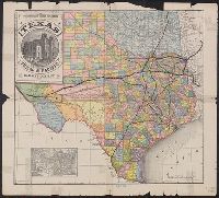
Alternative Title:
Proposed lines of the International R.R. of Mexico., Railroad map of Texas, Texas New Yorker., Texas New Yorker's map of the United States., and Travelers' and immigrants' guide, or railroad map to Texas
Description:
"Entered according to act of Congress in the year 1874 by Geo. H. Sweet in the office of the Librarian of Congress at Washington."
Publisher:
Geo. H. Sweet,
Subject (Name):
Streeter, Thomas W.--(Thomas Winthrop),--1883-1965--Ownership and Sweet, George H
Subject (Topic):
Railroads--Mexico--Maps, Railroads--Texas--Maps, and Railroads--United States--Maps
Found in:
Beinecke Rare Book and Manuscript Library > "Texas New Yorker's" railroad map of Texas : showing all completed and proposed routes, with principal rivers, county boundaries and county-seats, railroad stations and distances, congressional districts, United States military telegraph line, and frontie
Published / Created:
1860?]
Call Number:
796gme 1860
Container / Volume:
BRBL_00531
Image Count:
1
Resource Type:
Maps, Atlases & Globes
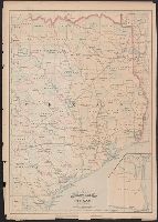
Alternative Title:
Red River, Sabine & Western Railway and Red River, Sabine and Western Railway
Description:
"I.[?] C. Terry, Chf. Eng."
Publisher:
s.n.,
Subject (Name):
Red River, Sabine and Western Railway--Maps and Streeter, Thomas W.--(Thomas Winthrop),--1883-1965--Ownership
Subject (Topic):
Coal--Texas--Maps, Forests and forestry--Louisiana--Maps, Forests and forestry--Texas--Maps, Iron--Texas--Maps, Petroleum--Texas--Maps, Railroads--Louisiana--Maps, and Railroads--Texas--Maps
Found in:
Beinecke Rare Book and Manuscript Library > A geographically correct map of the Red River, Sabine & Western Railway (under construction) and connections : showing distribution of pine forests (compiled from maps of U.S. government), also location of coal, iron, and oil deposits.
Published / Created:
[1890?]
Call Number:
796gme 1890
Container / Volume:
BRBL_00531
Image Count:
1
Resource Type:
Maps, Atlases & Globes
Description:
Includes ill. of "Court House, Paris, Texas" and inset of United States.
Publisher:
Land Dept. of the Texas & Pacific Railway Co.,
Subject (Geographic):
Texas--Administrative and political divisions--Maps and Texas--Maps
Subject (Name):
Texas & Pacific Railway. Land Dept and Texas & Pacific Railway--Maps
Subject (Topic):
Railroad land grants--Texas--Maps and Railroads--Texas--Maps
Found in:
Beinecke Rare Book and Manuscript Library > A geographically correct map of the state of Texas.
Creator:
Published / Created:
[1878?]
Call Number:
796fb 1878A
Container / Volume:
BRBL_00530
Image Count:
1
Resource Type:
Maps, Atlases & Globes
Alternative Title:
Asher and Adams' Texas and Texas
Description:
"55" and "56" in right margin.
Publisher:
Asher & Adams,
Subject (Geographic):
Texas--Administrative and political divisions--Maps and Texas--Maps
Subject (Name):
Streeter, Thomas W.--(Thomas Winthrop),--1883-1965--Ownership
Subject (Topic):
Railroads--Texas--Maps
Found in:
Beinecke Rare Book and Manuscript Library > Asher & Adams' Texas : eastern portion.
Creator:
Published / Created:
Jan.y 1st 1869.
Call Number:
796 H818 1869
Container / Volume:
BRBL_00527A
Image Count:
4
Resource Type:
Maps, Atlases & Globes
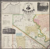
Alternative Title:
Houston, Harris Co., Texas
Description:
"Entered according to act of Congress in the year 1868 by W.E. Wood in the clerks office of the district court for the eastern district of Texas."
Publisher:
W.E. Wood,
Subject (Geographic):
Houston (Tex.)--Maps
Subject (Name):
Blessing, J. P and Rease, W. H
Subject (Topic):
Election districts--Texas--Houston--Maps, Railroads--Texas--Maps, and Real property--Texas--Houston--Maps
Found in:
Beinecke Rare Book and Manuscript Library > City of Houston, Harris Co., Texas / published from actual surveys by W.E. Wood, C.E. ; lith. by W.H. Rease ; views by J.P. Blessing.
Creator:
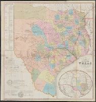
Published / Created:
1877
Call Number:
796 1877A
Container / Volume:
BRBL_00526
Image Count:
3
Resource Type:
Maps, Atlases & Globes
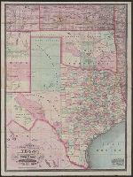
Alternative Title:
New county and railroad map of Texas and Indian Territory and New railroad and township map of Texas and Indian Territ'y
Description:
"Entered according to act of Congress in the year 1873 by G.F. Cram in the office of the librarian of Congress at Washington, D.C."
Publisher:
George F. Cram,
Subject (Geographic):
Indian Territory--Maps, Texas--Administrative and political divisions--Maps, and Texas--Maps
Subject (Topic):
Railroads--Indian Territory--Maps and Railroads--Texas--Maps
Found in:
Beinecke Rare Book and Manuscript Library > Cram's new county and railroad map of Texas and Indian Territory : showing latest government surveys &c &c / Geo. F. Cram, lith.
Creator:
Published / Created:
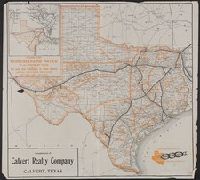
c1909.
Call Number:
796gme 1909
Container / Volume:
BRBL_00531
Image Count:
1
Resource Type:
Maps, Atlases & Globes
Alternative Title:
Iron mountain route, the way to Texas and Way to Texas
Description:
"Compliments of Calvert Realty Company, Calvert, Texas."
Publisher:
Poole Bros.,
Subject (Geographic):
Texas--Maps
Subject (Name):
Calvert Realty Company, International & Great Northern Railroad, International & Great Northern Railroad--Maps, Texas & Pacific Railway, and Texas & Pacific Railway--Maps
Subject (Topic):
Agricultural geography--Texas--Maps and Railroads--Texas--Maps
Found in:
Beinecke Rare Book and Manuscript Library > Iron mountain route to all parts of Texas : the way to Texas.
Creator:
Published / Created:
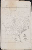
1853
Call Number:
796 1853
Container / Volume:
BRBL_00525
Image Count:
1
Resource Type:
Maps, Atlases & Globes
Alternative Title:
Map of the state of Texas and State of Texas
Description:
"Entered according to act of Congress on the 28th day of July 1848 by J. De Cordova in the clerk's office of the United States district court for the district of Texas."
Publisher:
s.n.],
Subject (Geographic):
Texas--Administrative and political divisions--Maps and Texas--Maps
Subject (Name):
Atwood, John M., b. ca. 1818 and De Cordova, Jacob, 1808-1868
Subject (Topic):
Railroads--Texas--Maps
Found in:
Beinecke Rare Book and Manuscript Library > J. De Cordova's map of the state of Texas / compiled from the records of the general land office of the state by Robert Creuzbaur ; engraved by J.M. Atwood.
Creator:
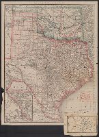
Published / Created:
1886
Call Number:
796 1886A
Container / Volume:
BRBL_00526
Image Count:
1
Resource Type:
Maps, Atlases & Globes
Alternative Title:
Rand, McNally & Co.'s Texas and Indian Territory and Texas and the Indian Territory
Description:
Includes map of western portion of Texas.
Publisher:
Rand, McNally & Co.,
Subject (Geographic):
Indian Territory--Maps, Texas--Administrative and political divisions--Maps, and Texas--Maps
Subject (Topic):
Railroads--Indian Territory--Maps, Railroads--Texas--Denison--Maps, and Railroads--Texas--Maps
Found in:
Beinecke Rare Book and Manuscript Library > Map of Texas and the Indian Territory.
Creator:
Published / Created:
1837?]
Call Number:
796fb 1837
Container / Volume:
BRBL_00530
Image Count:
1
Resource Type:
Maps, Atlases & Globes
Alternative Title:
City of Galveston, on Galveston Island, in Texas.
Description:
Appears in City of Galveston, on Galveston Island, in Texas. 1837.
Publisher:
s.n.,
Subject (Geographic):
Texas--Administrative and political divisions--Maps and Texas--Maps
Subject (Name):
Swartwout, Robert
Subject (Topic):
Railroads--Texas--Maps
Found in:
Beinecke Rare Book and Manuscript Library > Map of the republic of Texas, shewing its division into counties and latest improvements to 1837 / compiled & written on stone by H. Groves.
Branch:v1.68.7 ,Deployed:2025-07-09T09:07:59-04:00