Bound, as issued, with the author's Tractaet vant zee-bouck-houden. [Amsterdam] 1597., Engraved t.-p., and Signatures: A⁴ (A2-3 signed A1-2) A-C⁸ A-E⁸.
Publisher:
Ghedruckt by Barendt Adriaenzoon in t' Vergulde Schryf-boeck ...,
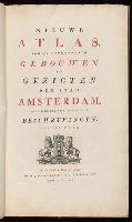
Descriptive letterpress in Dutch and French at foot of most of the plates., Engraved title vignette (coat of arms of Amsterdam)., First edition (in book form) was published about 1770 under title: Afbeeldingen van de wijd vermaarde koopstad Amsterdam, benevens deszelfs voornaamste gebouwen en gezigten (Amsterdam, P. Fouquet jr.)--cf. Muller, Frederik, & co. Oud-Amsterdam [1912], p. 14., and Paged continuously (by signatures).
Descriptio ac delineatio geographica detectionis freti, sive, transitus ad occasum supra terras
Image Count:
1
Abstract:
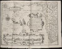
Map depicts the Coat of Arms of the United Kingdom (era of the Union of the Crowns), reigning between the years 1603-1707.
Alternative Title:
Tabula nautica, qua repraesentantur orae maritimae, meatus, ac freta, noviter a H. Hudsono Anglo ad Caurum supra Novam Franciam
Description:
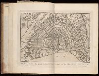
Bound in after p. [2]., In pencil on recto: 170., Map cut and folded irregularly., Map has multiple small stains on both the recto and verso., and Scale [ca. 1:9,000,000].
Nauigatio ac itinerarium Iohannis Hugonis Linscotani in Orientalem siue Lusitanorum Indiam
Image Count:
1
Description:
[Scale ca. 1:13,000,000]., Bound in following title page of "Descriptio totius Guineae tractus ...", In ink on top left panel of left verso: 3., and Map has several small tears now repaired on verso.
Subject (Geographic):
Africa, West --Maps --Early works to 1800
Subject (Name):
Claesz, Cornelis, ca. 1546-1609, publisher, Elzevier, Gillis, bookseller, and Hendricksz, Aelbrecht, fl. 1573-1605, printer
Subject (Topic):
Voyages and travels --Early works to 1800
Collection Created:
Hagae-Comitis : Ex officina Alberti Henrici, impensis authoris & Cornelii Nicolai, prostantque apud Aegidium Elseuirum, anno 1599