New York (State)--Administrative and political divisions--Maps--Early works to 1800, New York (State)--Upstate New York, and Upstate New York (N.Y.)--Administrative and political divisions--Maps--Early works to 1800
Subject (Name):
Tiebout, Cornelius, 1777-1832
Subject (Topic):
Administrative and political divisions, Indian reservations--New York (State)--Maps--Early works to 1800., Landowners--New York (State)--Maps--Early works to 1800., and Landowners--New York (State)--Upstate New York--Maps--Ear
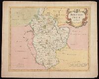
Covers Nova Scotia, New Brunswick, Prince Edward Island, and part of Quebec.
Publisher:
Publish'd according to Act of Parlian't Apr'l 21st, 1749, by Ino. Gibson engraver in Bartlet Street Clerkenwell & sold by the printsellers in London & Westminster,
Subject (Geographic):
Acadia--Maps--Early works to 1800., Maritime Provinces--Maps--Early works to 1800., North America--Acadia, and Québec (Province)--Maps--Early works to 1800.
Navigantium atque itinerantium bibliotheca ; Or, A complete collection of voyages and travels
Image Count:
1
Resource Type:
Maps, Atlases & Globes
Alternative Title:
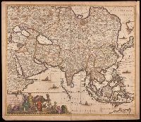
New and accurate map of China
Description:
From: Navigantium atque itinerantium bibliotheca, or, A complete collection of voyages and travels / originally published in two volumes in folio, by John Harris. London : Printed for T. Osborne [and others], 1764.
Publisher:
[Printed for T. Osborne],
Subject (Geographic):
China--Maps--Early works to 1800.
Subject (Name):
Harris, John, 1667?-1719. Navigantium atque itinerantium bibliotheca.
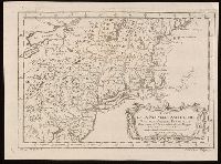
North-American pilot for New England, New York, Pensilvania, Maryland, and Virginia.
Description:
A Scale of 5 "English Miles" is given below the title at upper left.
Publisher:
Printed for Robt. Sayer & John Bennett, sea chart & map-sellers, No. 53, in Fleet Street. Published as the Act directs,
Subject (Geographic):
Atlantic Ocean--Lower Bay, Atlantic Ocean--Upper Bay, New Jersey--Sandy Hook, New York Harbor (N.Y. and N.J.) Maps--Early works to 1800., New York Region--Maps--Early works to 1800., and Sandy Hook (N.J.)
Subject (Name):
Robert Sayer and John Bennett (Firm), printmaker, printseller
Subject (Topic):
Nautical charts, Nautical charts--Hudson River Estuary (N.Y. and N.J.)--Early works to 1800., Nautical charts--Lower Bay (N.Y. and N.J.)--Early works to 1800., and Nautical charts--Upper Bay (N.Y. and N.J.)--Early works to 180
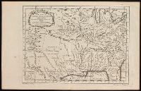
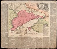
Nachricht von denen gegen die Türcken und Tartarn in diesem 1736sten Jahre vorgefallenen Kriegs-Operationen der Russisch-Kayserlichen Armée.
Description:
Imperfect: chipped along edges, with some loss of text. Reinforced with paper at top. Manuscript number 76 in upper right corner. Manuscript waste pasted to verso. From the Karpinski-von Wieser Map Collection.
Publisher:
Zu haben bey Matthaeus Seutter
Subject (Geographic):
Russia--History, Military--18th century--Maps--Early works to 1800., Ukraine, Ukraine--History, Military--18th century--Maps--Early works to 1800., and Ukraine--Maps--Early works to 1800.
Subject (Name):
Imperatorskai︠a︡ akademīi︠a︡ nauk (Russia) and Russo-Turkish War (1736-1739)
Subject (Topic):
Military campaigns and Russo-Turkish War, 1736-1739--Campaigns--Ukraine--Maps--Early works to 1800.