Search
You Searched For
Search Results
- Creator:
- Herrera y Tordesillas, Antonio de, d. 1625
- Published / Created:
- 1622]
- Call Number:
- 85 1622
- Container / Volume:
- BRBL_00692
- Image Count:
- 1
- Resource Type:
- Maps, Atlases & Globes
- Description:
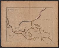
- North America, Central America, northern
- Subject (Topic):
- Coasts--Central America--Maps--Early
- Found in:
- Beinecke Rare Book and Manuscript Library > Descripcion de las Yndias del Norte, 2.
- Published / Created:
- 1756
- Call Number:
- 755 1756
- Container / Volume:
- BRBL_00428
- Image Count:
- 1
- Resource Type:
- Maps, Atlases & Globes
- Description:
- Inset map: "Suplement pour les poβeβ
- Subject (Geographic):
- North America--Maps--Early works to
- Subject (Topic):
- British--North America--Maps--Early
- Found in:
- Beinecke Rare Book and Manuscript Library > Carte des possessions Françoises et Angloises dans le Canada, et partie de la Louisiane / L. Thevenard fil. sculp.
- Creator:
- Tirion, Isaak
- Published / Created:
- [1769]
- Call Number:
- 755 1755F
- Container / Volume:
- BRBL_00427
- Image Count:
- 1
- Resource Type:
- Maps, Atlases & Globes
- Description:
- Although the map bears the date of 1755
- Subject (Geographic):
- North America--Maps--Early works to
- Subject (Topic):
- British--America--Maps--Early works to
- Found in:
- Beinecke Rare Book and Manuscript Library > Nieuwe kaart van de grootbrittannische Volkplantingen in Noort America .../ Isaak Tirion 1755.
- Creator:
- Tirion, Isaak
- Published / Created:
- [1769]
- Call Number:
- 755 1755Z
- Container / Volume:
- BRBL_00427
- Image Count:
- 1
- Resource Type:
- Maps, Atlases & Globes
- Description:
- Although the map bears the date of 1755
- Subject (Geographic):
- North America--Maps--Early works to
- Subject (Topic):
- British--America--Maps--Early works to
- Found in:
- Beinecke Rare Book and Manuscript Library > Nieuwe kaart van de grootbrittannische Volkplantingen in Noort America .../ Isaak Tirion 1755.
- Published / Created:
- [1756?]
- Call Number:
- 755 1756C
- Container / Volume:
- BRBL_00428
- Image Count:
- 1
- Resource Type:
- Maps, Atlases & Globes
- Subject (Geographic):
- North America--Maps--Early works to
- Subject (Topic):
- British--North America--Maps--Early
- Found in:
- Beinecke Rare Book and Manuscript Library > The British & French dominions in North America : particularly shewing the French encroachments through all the British plantations from Nova Scotia down to the Gulf of Mexico.
- Creator:
- Robert de Vaugondy, Didier, 1723-1786
- Published / Created:
- 1753
- Call Number:
- 755 1760D
- Container / Volume:
- BRBL_00428
- Image Count:
- 1
- Resource Type:
- Maps, Atlases & Globes
- Description:
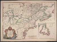
- Inset map: "Supplément pour l'isle de
- Subject (Geographic):
- Canada--Maps--Early works to 1800
- Subject (Topic):
- British--America--Maps--Early works to
- Found in:
- Beinecke Rare Book and Manuscript Library > Carte des pays connus sous le nom de Canada : dans laquelle sont distinguées les possessions françoises, & angl? Dédiée et présentée a monseigneur le Comte d'Argenson, ministre sécrétaire d'Etat pour le département de la guerre / par le Sr. Rober
- Published / Created:
- 1756
- Call Number:
- 755 1756A
- Container / Volume:
- BRBL_00428
- Image Count:
- 1
- Resource Type:
- Maps, Atlases & Globes
- Subject (Geographic):
- North America--Maps--Early works to
- Subject (Topic):
- British--North America--Maps--Early
- Found in:
- Beinecke Rare Book and Manuscript Library > Carte du Canada et de la Louisiane qui forment la Nouvelle France et des colonies Angloises ou sont representez les pays contestez ... / par J. B. Nolin ...
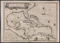
- Creator:
- Ruyter, Balthasar
- Published / Created:
- ca. 1747?]
- Call Number:
- 85 1702
- Container / Volume:
- BRBL_00692
- Image Count:
- 1
- Resource Type:
- Maps, Atlases & Globes
- Description:
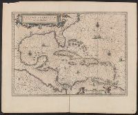
- Shows southern North America, Central
- Subject (Geographic):
- Caribbean Area--Maps--Early works to
- Subject (Topic):
- Coasts--North America--Maps--Early
- Found in:
- Beinecke Rare Book and Manuscript Library > Kaarte van de Golf van Mexico en het Zuyd America : waar in Porto-Bello en Panama aangewezen werden / B Ruyter Sc.
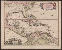
- Creator:
- Jansson, Jan, 1588-1664
- Published / Created:
- [1645]
- Call Number:
- 85 1652
- Container / Volume:
- BRBL_00636
- Image Count:
- 2
- Resource Type:
- Maps, Atlases & Globes
- Description:
- Shows southeast coast of North America
- Subject (Geographic):
- Caribbean Area--Maps--Early works to
- Subject (Topic):
- Coasts--North America--Maps--Early
- Found in:
- Beinecke Rare Book and Manuscript Library > Insulae Americanae in Oceano Septentrionali cum terris adiacentibus [cartographic material].
- Creator:
- Palairet, Jean, 1697-1774
- Published / Created:
- 1756
- Call Number:
- 755 1756D
- Container / Volume:
- BRBL_00428
- Image Count:
- 1
- Resource Type:
- Maps, Atlases & Globes
- Description:
- , map 18, issue 1756 (c).
- Subject (Geographic):
- North America--Maps--Early works to
- Subject (Topic):
- British--North America--Maps--Early
- Found in:
- Beinecke Rare Book and Manuscript Library > Carte des possessions angloises & françoises du continent de l'Amérique septentrionale / par I. Palairet, Londres ; Thos. Kitchin, sculpt.
- Creator:
- Delarochette, L. (Louis), 1731-1802
- Published / Created:
- 1765
- Call Number:
- 71 1765
- Container / Volume:
- BRBL_00364
- Image Count:
- 1
- Resource Type:
- Maps, Atlases & Globes
- Subject (Geographic):
- North America--Maps--Early works to
- Subject (Topic):
- British--America--Maps--Early works to
- Found in:
- Beinecke Rare Book and Manuscript Library > A map of North America / by J. Palairet, with considerable alterations & improvements from d'Anville, Mitchell & Bellin, by L. Delarochette.
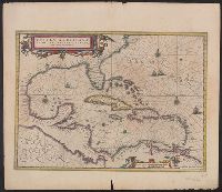
- Creator:
- Jansson, Jan, 1588-1664
- Published / Created:
- [1660?]
- Call Number:
- 85 1660
- Container / Volume:
- BRBL_00636
- Image Count:
- 1
- Resource Type:
- Maps, Atlases & Globes
- Description:
- Shows southeast coast of North America
- Subject (Geographic):
- Caribbean Area--Maps--Early works to
- Subject (Topic):
- Coasts--North America--Maps--Early
- Found in:
- Beinecke Rare Book and Manuscript Library > Insulae Americanae in Oceano Septentrionali cum terris adiacentibus [cartographic material].
- Creator:
- Visscher, Nicolaes, 1649-1702
- Published / Created:
- ca. 1682]
- Call Number:
- 85 1650A
- Container / Volume:
- BRBL_00692
- Image Count:
- 1
- Resource Type:
- Maps, Atlases & Globes
- Description:
- America from Florida to the northern part of
- Subject (Geographic):
- Caribbean Area--Maps--Early works to
- Subject (Topic):
- Coasts--North America--Maps--Early
- Found in:
- Beinecke Rare Book and Manuscript Library > Insulae Americanae in Oceano Septentrionali ac regiones adiacentes : a C. de May usque ad Lineam Aequinoctialem / per Nicolaum Visscher.
- Creator:
- Jansson, Jan, 1588-1664
- Published / Created:
- [1638]
- Call Number:
- 85 1660A
- Container / Volume:
- BRBL_00692
- Image Count:
- 2
- Resource Type:
- Maps, Atlases & Globes
- Description:
- Show southeast coast of North America
- Subject (Geographic):
- Caribbean Area--Maps--Early works to
- Subject (Topic):
- Coasts--North America--Maps--Early
- Found in:
- Beinecke Rare Book and Manuscript Library > Insulae Americanae in Oceano Septentrionali cum terris adiacentibus.
- Creator:
- Pownall, Thomas, 1722-1805
- Published / Created:
- 1786
- Call Number:
- 71 1783
- Container / Volume:
- BRBL_00366
- Image Count:
- 2
- Resource Type:
- Maps, Atlases & Globes
- Description:
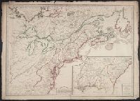
- insets "A particular map of Baffin and
- Publisher:
- Printed for Robt. Sayer, map, chart
- Subject (Geographic):
- North America--Maps--Early works to
- Subject (Topic):
- British--America--Maps--Early works to
- Found in:
- Beinecke Rare Book and Manuscript Library > A new map of North America, with the West India Islands : divided according to the preliminary articles of peace, signed at Versailles, 20, Jan. 1783. Wherein are particularly distinguished the United States and the several provinces, governments &ca. whi
- Creator:
- Herbert, William, 1718-1795
- Published / Created:
- 1755
- Call Number:
- 755 1755W
- Container / Volume:
- BRBL_00427
- Image Count:
- 1
- Resource Type:
- Maps, Atlases & Globes
- Description:
- Includes inset showing North America
- Subject (Geographic):
- North America--Maps--Early works to
- Subject (Topic):
- British--America--Maps--Early works to
- Found in:
- Beinecke Rare Book and Manuscript Library > A new and accurate map of the English empire in North America : representing their rightful claim as confirm'd by charters, and the formal surrender of their Indian friends; likewise the encroachments of the French, with the several forts they have unjust
- Creator:
- Pownall, Thomas, 1722-1805
- Published / Created:
- 1777
- Call Number:
- 71 1777B
- Container / Volume:
- BRBL_00365
- Image Count:
- 1
- Resource Type:
- Maps, Atlases & Globes
- Description:
- particular map of Baffin and Hudson's Bay" and
- Subject (Geographic):
- North America--Maps--Early works to
- Subject (Topic):
- British--America--Maps--Early works to
- Found in:
- Beinecke Rare Book and Manuscript Library > A new and correct map of North America, with the West India Islands : divided according to the last treaty of peace, concluded at Paris. 10th. Feby. 1763, wherein are particularly distinguished, the several provinces and colonies, which compose the Britis
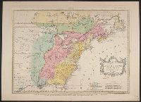
- Creator:
- Gibson, J. (John)
- Published / Created:
- 1758
- Call Number:
- 755 1758
- Container / Volume:
- BRBL_00428
- Image Count:
- 1
- Resource Type:
- Maps, Atlases & Globes
- Subject (Geographic):
- North America--Maps--Early works to
- Subject (Topic):
- British--America--Maps--Early works to
- Found in:
- Beinecke Rare Book and Manuscript Library > A general map of the middle British colonies in America : viz. Virginia, Maryland, Delaware, Pensilvania, New-Jersey, New-York, Connecticut and Rhode-Island : of Aquanishuonigy the country of the confederate Indians comprehending Aquanishuonigy proper, th
- Creator:
- Pownall, Thomas, 1722-1805
- Published / Created:
- between 1783 and 1799?]
- Call Number:
- 71 1785C
- Container / Volume:
- BRBL_00366
- Image Count:
- 2
- Resource Type:
- Maps, Atlases & Globes
- Alternative Title:
- Map of North America and the West
- Description:
- An issue of the Pownall map of North
- Subject (Geographic):
- North America--Maps--Early works to
- Subject (Topic):
- British--America--Maps--Early works to
- Found in:
- Beinecke Rare Book and Manuscript Library > [Pownall's map of North America and the West Indies].
- Creator:
- Mitchell, John, 1711-1768
- Published / Created:
- [1755]
- Call Number:
- 71 1755D
- Image Count:
- 8
- Resource Type:
- Maps, Atlases & Globes
- Description:
- and impressions, see the Osher Map Library
- Subject (Geographic):
- France--Colonies--America--Maps--Early
- Subject (Topic):
- British--America--Maps--Early works to
- Found in:
- Beinecke Rare Book and Manuscript Library > A map of the British and French dominions in North America : with the roads, distances, limits, and extent of the settlements, humbly inscribed to the Right Honourable the Earl of Halifax, and the other Right Honourable the Lords Commissioners for Trade &