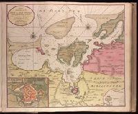
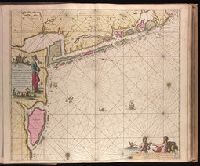
Haven en Stad Wismar and Stad Wismar met alles desselfs Sterktens.
Description:
"Aen de niuwe brugh met previlegie"., Appeared in Gerard van Keulen's Nieuwe groote ligtende Zee-Fakkel ... 1734; cf. Koeman, C. Atlantes Neerlandici, IV, Keu 45, map 22., Backed with paper. Ms. no. "9" [partially trimmed] in upper right-hand corner. Sheet measures 53.5 x 62.5 cm. No. 8 of 87 maps bound together., Bar scale given in "Duytsche Myl"., Includes inset map "De stad Wismar met alles desselfs Sterktens"., Relief shown pictorially; depths shown by soundings., and Watermark.
Publisher:
By Gerard van Keulen,
Subject (Geographic):
Wismar (Germany)--Maps--Early works to 1800.
Subject (Name):
Keulen, Gerard van. Nieuwe groote lichtende zee-fakkel.
Subject (Topic):
Nautical charts--Germany--Wismar Bay--Early works to 1800.
"Met prevelegie voor 15 Jaer"., Appeared in Gerard van Keulen's Nieuwe groote ligtende Zee-Fakkel ... 1734; cf. Koeman, C. Atlantes Neerlandici, IV, Keu 45, map 9., Backed with paper. Ms. no. "43" in upper right-hand corner. Sheet measures 53.7 x 62.9 cm. No. 41 of 87 maps bound together., Bar scales given in "Duytsche Mylen," "Spaensche Mylen," and "Eng. Fratn. Mylen"., Depths shown by soundings., and With north oriented towards the bottom.
Publisher:
By Ioannes van Keulen ...,
Subject (Geographic):
West Frisian Islands (Netherlands)--Maps--Early works to 1800.
Subject (Name):
Keulen, Gerard van. Nieuwe groote lichtende zee-fakkel.
Subject (Topic):
Nautical charts--Netherlands--West Frisian Islands--Early works to 1800.
"18" in lower right corner., "Met Previlegie voor 15 Iaar"., Appeared in Gerard van Keulen's Nieuwe groote ligtende Zee-Fakkel ... 1734; cf. Koeman, C. Atlantes Neerlandici, IV, Keu 45, map 30., Backed with paper. Ms. no. "14" in upper right-hand corner. Sheet measures 53.6 x 62.5 cm. No. 14 of 87 maps bound together., Includes four bar scales, Relief shown pictorially; depths shown by soundings., Watermark., and With north oriented towards the right.
Publisher:
By Johannes van Keulen ...,
Subject (Geographic):
Finland--Maps--Early works to 1800. and Sweden--Maps--Early works to 1800.
Subject (Name):
Keulen, Gerard van. Nieuwe groote lichtende zee-fakkel. and Vooght, Claes Janszoon, -1696.
Subject (Topic):
Nautical charts--Bothnia, Gulf of--Early works to 1800.
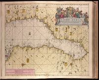
"28" in lower right corner., Appeard in Gerard van Keulen's Nieuwe groote ligtende Zee-Fakkel ... 1734; cf. Koeman, C. Atlantes Neerlandici, IV, Keu 45, map 56., Backed with paper. Ms. no. "6" in upper right-hand corner. Sheet measures 53.4 x 62.0 cm. No. 5 of 87 maps bound together., Bar scales given in "Duytsche Mylen," "Spaansche Mylen," and "Eng. en Fran. Mylen"., Includes smaller scale map of coast at top, "Paskaart van een Gedeelte van 't Liet van Bergen In 't Groot"., Relief shown pictorially., Watermark., and With north oriented towards the left.
Publisher:
By Iohannis van Keulen ...,
Subject (Geographic):
Hordaland fylke (Norway)--Maps--Early works to 1800.
Subject (Name):
Keulen, Gerard van. Nieuwe groote lichtende zee-fakkel.
Appeared in various editions of Gerard van Keulen's Groote nieuwe Vermeerderde Zee-Atlas ofte Water-Werelt and Nieuwe groote ligtende Zee-Fakkel., Bar scales given in "Duytsche Mylen" and "Engelse en France Mylen.", Imperfect: stains at bottom, with no loss of text. Backed with paper. Ms. no. "94" in upper right-hand corner. Joined sheets measure 53.5 x 65.0 sm. or smaller. No. 84 of 87 maps bound together., Includes illustrations and decorative cartouche., Includes inset: "Afteekening van t'inkomen van de rivier van Suriname...", Oriented with south at the top., Relief shown pictorially; depths shown by soundings., and With north oriented towards the bottom.
Publisher:
By Gerard van Keulen,
Subject (Geographic):
Suriname--Maps--Early works to 1800.
Subject (Name):
Keulen, Gerard van. Groote nieuwe vermeerderde zee-atlas ofte water-waereld. and Keulen, Gerard van. Nieuwe groote lichtende zee-fakkel.
Subject (Topic):
Coasts--Suriname--Maps--Early works to 1800., Nautical charts--Suriname--Early works to 1800., and Rivers--Suriname--Maps--Early works to 1800.
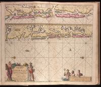
"30" in lower right corner., Appeard in Gerard van Keulen's Nieuwe groote ligtende Zee-Fakkel ... 1734; cf. Koeman, C. Atlantes Neerlandici, IV, Keu 45, map 58., Backed with paper. Ms. no. "7" in upper right-hand corner. Sheet measures 53.6 x 62.6 cm. No. 6 of 87 maps bound together., Bar scales given in "Duytsche Mylen," "Spaansche Mylen," and "Eng. en Fran. Mylen"., Relief shown pictorially., and With north oriented towards the bottom.
Publisher:
By Iohannis van Keulen ...,
Subject (Geographic):
Sør-Trøndelag (Norway)--Maps--Early works to 1800.
Subject (Name):
Keulen, Gerard van. Nieuwe groote lichtende zee-fakkel.
Subject (Topic):
Coasts--Norway--Maps--Early works to 1800. and Nautical charts--Norway--Trondheim Fjord--Early works to 1800.
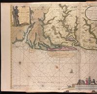
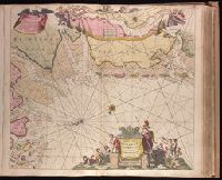
Paskaartie van de rievier de Elve streckende van Oldenbroek tot Hamburgh.
Description:
"Met priviligie voor 15 Laar"., Appeared in Gerard van Keulen's Nieuwe groote ligtende Zee-Fakkel ... 1734; cf. Koeman, C. Atlantes Neerlandici, IV, Keu 45, map 10., Bar scales given in "Duytsche Mylen," "Spaensche Mylen," and "Eng. en Fransiche Mylen"., Depths shown by soundings., Imperfect: western sheet wanting. Backed with paper. Ms. no. "44" in upper right-hand corner. No. 42 of 87 maps bound together., Inset: Paskaartie van de rievier de Elve streckende van Oldenbroek tot Hamburgh., With arrow indicating sea current., and With north oriented towards the bottom.
Publisher:
By Ioannes van Keulen, Boekverkooper en Graetboogmaaker aan de Nieubrug in de Gekroonde Loots-man,
Subject (Geographic):
Groningen (Netherlands : Province)--Maps--Early works to 1800., Lower Saxony (Germany)--Maps--Early works to 1800., and North Sea--Maps--Early works to 1800.
Subject (Name):
Keulen, Gerard van. Nieuwe groote lichtende zee-fakkel.