Delarochette, L. (Louis), 1731-1802, cartographer.
Call Number:
23 1794A
Image Count:
1
Resource Type:
Maps, Atlases & Globes
Alternative Title:
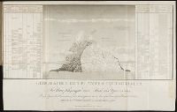
Chart of the northwest coast of America and the northeast coast of Asia, explored in the years 1778 and 1779
Description:
Below title: Advertisement, the interesting discoveries made by British and American ships since the first publication of this chart in 1784, together with the hydrographical materials lately procured from St. Petersburg and other places , have enabled Mr. De la Rochette to lay down the numerous improvements which appear in the present edition, Charing Cross, January 1st, 1794, W. Faden., Includes notes., Relief shown pictorially. Depths shown by soundings., and With watermark dated 1801.
Subject (Geographic):
Bering Strait Region--Discovery and exploration--Maps--Early works to 1800., North America--Discovery and exploration--Maps--Early works to 1800., Pacific Coast (North America)--Discovery and exploration--Maps--Early works to 1800., and Russian Far East (Russia)--Discovery and exploration--Maps--Early works to 1800.
Subject (Name):
Cook, James,--1728-1779., Faden, William, 1749-1836, publisher., Palmer, W. (William), 1739-1812, engraver., and Roberts, Henry, 1757-1796.
Subject (Topic):
Discoveries in geography. and Discoveries in geography--Maps--Early works to 1800.
Essai sur la geographie des plantes, accompagne dun tableau physique des regions equinoxiales
Image Count:
1
Resource Type:
Prints & Photographs
Description:
At foot: Esquisse et redige par M. de Humboldt, dessine par Schonberger et turpin a Paris en 1805, grave par Bouquetm la Lettre par Beauble, imprime par Langlois.
Subject (Geographic):
South America
Subject (Topic):
Botany --South America., Discoveries in geography., and Plants
Lart de navigver de M. Pierre de Medine Espagnol : contenant toutes les reigles, secrets
Image Count:
1
Abstract:
Map showing western Europe, northwest Africa, coastal North America and northern South America. and Signed at lower left: Par N. Nicolai du daulphine Geographe du Roy.
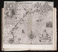
The generall historie of Virginia, New-England, and the Summer Isles : with the names of the
Image Count:
1
Abstract:
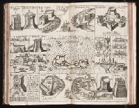
"A description of part of the adventures of Cap. Smith in Virginia." and Nine engraved vignettes with inset map.
Description:
Map of "Ould Virginia" (Church 3rd/Sabin 4th state) facing p. 21
Subject (Geographic):
Virginia --History --Colonial period, ca. 1600-1775
Subject (Topic):
Discoveries in geography., First contact of aboriginal peoples with Westerners., Indians of North America --Virginia --Early works to 1800., and Voyages and travels
Collection Created:
London : Printed by I.[ohn] D.[awson] and I.[ohn] H.[aviland] for Edward Blackmore, anno 1632
Atlas geographique et physique du royaume de la Nouvelle-Espagne, fonde sur des observations
Image Count:
1
Resource Type:
Maps, Atlases & Globes
Description:
At foot: Redige d'apres les dessins de Don Ignacio Castera et Don Luis Martin par F. Friesen 1808 / Grave par Bouquet - et l'Ecriture gravee par L. Aubert pere and Includes scale