Search
You Searched For
Search Results
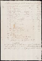
- Creator:
- Lewis, Meriwether, 1774-1809
- Published / Created:
- undated
- Call Number:
- WA MSS 303
- Collection Title:
- Lewis and Clark Expedition maps and receipt, ca. 1803-1810
- Container / Volume:
- Box 1 | Folder 3r
- Image Count:
- 1
- Found in:
- Beinecke Rare Book and Manuscript Library > "A Memorandum of Articles in readiness for the Voyage," manuscript list
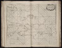
- Creator:
- Sarony & Major
- Call Number:
- A52 030 1
- Collection Title:
- Ancient monuments of the Mississippi Valley: comprising the results of extensive original surveys
- Image Count:
- 1
- Found in:
- Beinecke Rare Book and Manuscript Library > "The serpent;" (Entry 1014) Adams County Ohio. Pl. XXXV [35]
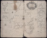
- Published / Created:
- undated
- Call Number:
- WA MSS S-2962
- Collection Title:
- Northern Pacific Railway Company maps and drawings
- Container / Volume:
- Box 1 | Map 11
- Image Count:
- 1
- Resource Type:
- Maps, Atlases & Globes
- Found in:
- Beinecke Rare Book and Manuscript Library > (IDAHO & WASHINGTON) [Anon.] [Untitled map of northwestern Idaho and northeastern Washington].
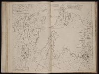
- Published / Created:
- undated
- Call Number:
- WA MSS S-2962
- Collection Title:
- Northern Pacific Railway Company maps and drawings
- Container / Volume:
- 3 (Roll) | Map 24
- Image Count:
- 1
- Resource Type:
- Maps, Atlases & Globes
- Found in:
- Beinecke Rare Book and Manuscript Library > (MONTANA & IDAHO) [Anon.] [Untitled map of far northwestern Montana and a part of the Idaho panhandle.]
- Published / Created:
- undated
- Call Number:
- WA MSS S-2962
- Collection Title:
- Northern Pacific Railway Company maps and drawings
- Container / Volume:
- Box 1 | Map 36
- Image Count:
- 1
- Resource Type:
- Maps, Atlases & Globes
- Found in:
- Beinecke Rare Book and Manuscript Library > (MONTANA) [Anon.] [Untitled map of a part of north central Montana.]
- Call Number:
- 8075cea 1848
- Container / Volume:
- BRBL_00551
- Image Count:
- 1
- Resource Type:
- Maps, Atlases & Globes
- Found in:
- Beinecke Rare Book and Manuscript Library > A Chart of Lake Erie ... Buffalo, A. Burke, 1848.
- Creator:
- Hutchins, Thomas, 1730-1789
- Call Number:
- Vanderbilt 147
- Collection Title:
- An historical account of the expedition against the Ohio Indians, in the year 1764. Under the
- Image Count:
- 1
- Found in:
- Beinecke Rare Book and Manuscript Library > A General map of the country on the Ohio and Mushkingham shewing the situation of the Indian-towns with respect to the army under the command of Colonel Bouquet by Thos. Hutchins. Asst. Engineer
- Call Number:
- Zd 147
- Collection Title:
- The history of the Five Indian nations of Canada : which are dependent on the province of New-York
- Image Count:
- 1
- Found in:
- Beinecke Rare Book and Manuscript Library > A Map of the country of the Five Nations, belonging to the province of New York; and of the lakes near which the nations of far Indians live, with part of Canada
- Creator:
- J. F. L
- Call Number:
- 1998 2141
- Collection Title:
- Der ausfuehrlichen nachrichten von der koeniglich-gross-britannischen colonie saltzburgischer
- Image Count:
- 1
- Found in:
- Beinecke Rare Book and Manuscript Library > A Map of the county of Savannah
- Call Number:
- Egf 789
- Collection Title:
- The American geography; or, A view of the present situation of the United States of America
- Image Count:
- 1
- Found in:
- Beinecke Rare Book and Manuscript Library > A Map of the northern and middle states; comprehending the western Territory and the British dominions in North America. Compiled from the best authorities
- Call Number:
- Taylor 376
- Collection Title:
- The discoveries of John Lederer : in three several marches from Virginia, to the west of Carolina
- Image Count:
- 1
- Found in:
- Beinecke Rare Book and Manuscript Library > A Map of the whole territory traversed by John Lederer in his three marches
- Call Number:
- CE143 A28
- Collection Title:
- An account of the Spanish settlements in America. In four parts ... To which is annexed, a succinct
- Image Count:
- 1
- Found in:
- Beinecke Rare Book and Manuscript Library > A New general map of America drawn from several accurate particular maps and charts and regulated by astronomical observations
- Call Number:
- 1989 +19
- Collection Title:
- A collection of voyages and travels, some now first printed from original manuscripts, others now
- Image Count:
- 1
- Resource Type:
- Maps, Atlases & Globes
- Found in:
- Beinecke Rare Book and Manuscript Library > A chart and map of the Gold Coast of Guinea from Rio da Corsa to Ro da Volta. vol. V [5], pl. K
- Published / Created:
- Undated
- Call Number:
- 1973 Folio 56
- Collection Title:
- The American pilot, containing the navigation of the sea coast of North America, from the Streights
- Image Count:
- 1
- Resource Type:
- Maps, Atlases & Globes
- Found in:
- Beinecke Rare Book and Manuscript Library > A chart of South Carolina and Georgia
- Call Number:
- 1978 Folio 10
- Collection Title:
- The English pilot: describing the West-India navigation, from Hudson's-Bay to the river Amazones
- Image Count:
- 2
- Found in:
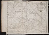
- Beinecke Rare Book and Manuscript Library > A chart of the Caribe Islands
- Call Number:
- 1973 Folio 76
- Collection Title:
- The English pilot: describing the sea-coasts, capes, head-lands, rivers, bays, roads, havens
- Image Count:
- 1
- Found in:
- Beinecke Rare Book and Manuscript Library > A chart of the Caribe ilands
- Call Number:
- 1976 1233
- Collection Title:
- Forty-two new maps of Asia, Africa, and America ... : all engrav’d, according to the latest
- Image Count:
- 1
- Found in:
- Beinecke Rare Book and Manuscript Library > A chart of the South Sea coast from the Steights [sic] of Magellan to Arica
- Call Number:
- 1976 1233
- Collection Title:
- Forty-two new maps of Asia, Africa, and America ... : all engrav’d, according to the latest
- Image Count:
- 1
- Found in:
- Beinecke Rare Book and Manuscript Library > A chart of the Streights of Magellan
- Creator:
- Waddington, Robert
- Call Number:
- 1973 Folio 116
- Collection Title:
- The English pilot: describing the West-India navigation, from Hudson's-Bay to the river Amazones
- Image Count:
- 1
- Found in:
- Beinecke Rare Book and Manuscript Library > A chart of the coast of Guayana, from the entrance of the River Orinoco ...
- Call Number:
- 1976 1233
- Collection Title:
- Forty-two new maps of Asia, Africa, and America ... : all engrav’d, according to the latest
- Image Count:
- 1
- Found in:
- Beinecke Rare Book and Manuscript Library > A chart of the coasts of Peru, Quito, Popayan and the isthmus of Darien
- Call Number:
- 1973 Folio 76
- Collection Title:
- The English pilot: describing the sea-coasts, capes, head-lands, rivers, bays, roads, havens
- Image Count:
- 1
- Found in:
- Beinecke Rare Book and Manuscript Library > A chart of the iland of Hispaniola
- Call Number:
- 1978 Folio 10
- Collection Title:
- The English pilot: describing the West-India navigation, from Hudson's-Bay to the river Amazones
- Image Count:
- 1
- Found in:
- Beinecke Rare Book and Manuscript Library > A chart of the island of Hispaniola
- Call Number:
- 1978 Folio 10
- Collection Title:
- The English pilot: describing the West-India navigation, from Hudson's-Bay to the river Amazones
- Image Count:
- 1
- Found in:
- Beinecke Rare Book and Manuscript Library > A chart of the sea coast of New Found Land, New Scotland, New England, New York, New Jersey, with Virginia and Maryland
- Call Number:
- 1973 Folio 114
- Collection Title:
- The English pilot: describing the West-India navigation, from Hudson's-Bay to the river Amazones
- Image Count:
- 1
- Resource Type:
- Maps, Atlases & Globes
- Found in:
- Beinecke Rare Book and Manuscript Library > A chart of the sea coast of Newfoundland, New Scotland, New England, New York, New Jersey, with Virginia and Maryland
- Call Number:
- 1973 Folio 116
- Collection Title:
- The English pilot: describing the West-India navigation, from Hudson's-Bay to the river Amazones
- Image Count:
- 1
- Found in:
- Beinecke Rare Book and Manuscript Library > A chart of the sea coast of Newfoundland, New Scotland, New England, New York, New Jersey, with Virginia and Maryland
- Call Number:
- 1974 Folio 72
- Collection Title:
- The English pilot: describing the West-India navigation, from Hudson's-Bay to the river Amazones
- Image Count:
- 1
- Found in:
- Beinecke Rare Book and Manuscript Library > A chart of the sea coast of Newfoundland, New Scotland, New England, New York, New Jersey, with Virginia and Maryland
- Creator:
- Moll, Herman, d. 1732
- Call Number:
- 85 1745A
- Container / Volume:
- BRBL_00636
- Image Count:
- 1
- Resource Type:
- Maps, Atlases & Globes
- Found in:
- Beinecke Rare Book and Manuscript Library > A chart of ye West-Indies or the islands of America in the North Sea &c., being ye present seat of war / by Herman Moll, geographer.
- Creator:
- Thornton, John, 1641-1708
- Call Number:
- 1973 Folio 76
- Collection Title:
- The English pilot: describing the sea-coasts, capes, head-lands, rivers, bays, roads, havens
- Image Count:
- 1
- Found in:
- Beinecke Rare Book and Manuscript Library > A chart of ye iland of New Found Land
- Creator:
- Thornton, John, 1641-1708
- Call Number:
- 1973 Folio 76
- Collection Title:
- The English pilot: describing the sea-coasts, capes, head-lands, rivers, bays, roads, havens
- Image Count:
- 1
- Found in:
- Beinecke Rare Book and Manuscript Library > A chart of ye north part of America
- Creator:
- Gaudy Iohn
Parker, S
- Call Number:
- 1973 Folio 114
- Collection Title:
- The English pilot: describing the West-India navigation, from Hudson's-Bay to the river Amazones
- Image Count:
- 1
- Resource Type:
- Maps, Atlases & Globes
- Found in:
- Beinecke Rare Book and Manuscript Library > A chart shewing part of the sea coast of New Foundland from ye Bay of Bulls to little Plecentia ...
- Creator:
- Gaudy, Iohn
Parker, S
- Call Number:
- 1973 Folio 116
- Collection Title:
- The English pilot: describing the West-India navigation, from Hudson's-Bay to the river Amazones
- Image Count:
- 1
- Found in:
- Beinecke Rare Book and Manuscript Library > A chart shewing part of the sea coast of New Foundland from ye Bay of Bulls to little Plecentia ...
- Creator:
- Gaudy, Iohn
- Call Number:
- 1974 Folio 72
- Collection Title:
- The English pilot: describing the West-India navigation, from Hudson's-Bay to the river Amazones
- Image Count:
- 1
- Found in:
- Beinecke Rare Book and Manuscript Library > A chart shewing part of the sea coast of New Foundland from ye Bay of Bulls to little Plecentia ...
- Creator:
- Price, Charles, fl. 1700-1707
- Call Number:
- 1973 Folio 114
- Collection Title:
- The English pilot: describing the West-India navigation, from Hudson's-Bay to the river Amazones
- Image Count:
- 1
- Resource Type:
- Maps, Atlases & Globes
- Found in:
- Beinecke Rare Book and Manuscript Library > A correct chart of Hispaniola with the Windward Passage
- Call Number:
- 1973 Folio 116
- Collection Title:
- The English pilot: describing the West-India navigation, from Hudson's-Bay to the river Amazones
- Image Count:
- 1
- Found in:
- Beinecke Rare Book and Manuscript Library > A correct chart of Hispaniola with the Windward Passage
- Call Number:
- 1974 Folio 72
- Collection Title:
- The English pilot: describing the West-India navigation, from Hudson's-Bay to the river Amazones
- Image Count:
- 1
- Found in:
- Beinecke Rare Book and Manuscript Library > A correct chart of Hispaniola with the Windward Passage
- Call Number:
- 1973 Folio 114
- Collection Title:
- The English pilot: describing the West-India navigation, from Hudson's-Bay to the river Amazones
- Image Count:
- 1
- Resource Type:
- Maps, Atlases & Globes
- Found in:
- Beinecke Rare Book and Manuscript Library > A correct chart of the Caribbee Islands
- Call Number:
- 1973 Folio 116
- Collection Title:
- The English pilot: describing the West-India navigation, from Hudson's-Bay to the river Amazones
- Image Count:
- 1
- Found in:
- Beinecke Rare Book and Manuscript Library > A correct chart of the Caribbee Islands
- Call Number:
- 1974 Folio 72
- Collection Title:
- The English pilot: describing the West-India navigation, from Hudson's-Bay to the river Amazones
- Image Count:
- 1
- Found in:
- Beinecke Rare Book and Manuscript Library > A correct chart of the Caribbee Islands
- Call Number:
- 1973 Folio 116
- Collection Title:
- The English pilot: describing the West-India navigation, from Hudson's-Bay to the river Amazones
- Image Count:
- 1
- Found in:
- Beinecke Rare Book and Manuscript Library > A correct map of the coast of New England
- Call Number:
- 1974 Folio 72
- Collection Title:
- The English pilot: describing the West-India navigation, from Hudson's-Bay to the river Amazones
- Image Count:
- 1
- Found in:
- Beinecke Rare Book and Manuscript Library > A correct map of the coast of New England
- Call Number:
- 1973 Folio 116
- Collection Title:
- The English pilot: describing the West-India navigation, from Hudson's-Bay to the river Amazones
- Image Count:
- 1
- Found in:
- Beinecke Rare Book and Manuscript Library > A description of the ports and islands upon the coast between the Amazones and Cape Florida
- Call Number:
- 1973 Folio 114
- Collection Title:
- The English pilot: describing the West-India navigation, from Hudson's-Bay to the river Amazones
- Image Count:
- 1
- Resource Type:
- Maps, Atlases & Globes
- Found in:
- Beinecke Rare Book and Manuscript Library > A description of the ports and islands upon the coast between the Amazons and Cape Florida
- Call Number:
- 1978 Folio 10
- Collection Title:
- The English pilot: describing the West-India navigation, from Hudson's-Bay to the river Amazones
- Image Count:
- 1
- Found in:
- Beinecke Rare Book and Manuscript Library > A description of the ports and islands upon the coast between the Amazons and Cape Florida
- Call Number:
- 1974 Folio 72
- Collection Title:
- The English pilot: describing the West-India navigation, from Hudson's-Bay to the river Amazones
- Image Count:
- 1
- Found in:
- Beinecke Rare Book and Manuscript Library > A description of the ports and islands upon the coast between the Amazons and Cape Florida
- Creator:
- Tiddeman, Mark
- Call Number:
- 1973 Folio 114
- Collection Title:
- The English pilot: describing the West-India navigation, from Hudson's-Bay to the river Amazones
- Image Count:
- 1
- Resource Type:
- Maps, Atlases & Globes
- Found in:
- Beinecke Rare Book and Manuscript Library > A draught of New York from the Hook to New Yorktown
- Creator:
- Tiddeman, Mark
- Call Number:
- 1973 Folio 116
- Collection Title:
- The English pilot: describing the West-India navigation, from Hudson's-Bay to the river Amazones
- Image Count:
- 1
- Found in:
- Beinecke Rare Book and Manuscript Library > A draught of New York from the Hook to New Yorktown
- Creator:
- Tiddeman, Mark
- Call Number:
- 1974 Folio 72
- Collection Title:
- The English pilot: describing the West-India navigation, from Hudson's-Bay to the river Amazones
- Image Count:
- 1
- Found in:
- Beinecke Rare Book and Manuscript Library > A draught of New York from the Hook to New Yorktown
- Creator:
- Tiddeman, Mark
- Call Number:
- 1973 Folio 114
- Collection Title:
- The English pilot: describing the West-India navigation, from Hudson's-Bay to the river Amazones
- Image Count:
- 1
- Resource Type:
- Maps, Atlases & Globes
- Found in:
- Beinecke Rare Book and Manuscript Library > A draught of Virginia from the capes to York in York River and to Kuiquotan or Hamton in James River
- Creator:
- Tiddeman, Mark
- Call Number:
- 1973 Folio 116
- Collection Title:
- The English pilot: describing the West-India navigation, from Hudson's-Bay to the river Amazones
- Image Count:
- 2
- Found in:
- Beinecke Rare Book and Manuscript Library > A draught of Virginia from the capes to York in York River and to Kuiquotan or Hamton in James River
- Creator:
- Tiddeman, Mark
- Call Number:
- 1974 Folio 72
- Collection Title:
- The English pilot: describing the West-India navigation, from Hudson's-Bay to the river Amazones
- Image Count:
- 1
- Found in:
- Beinecke Rare Book and Manuscript Library > A draught of Virginia from the capes to York in York River and to Kuiquotan or Hamton in James River
- Call Number:
- 1973 Folio 114
- Collection Title:
- The English pilot: describing the West-India navigation, from Hudson's-Bay to the river Amazones
- Image Count:
- 1
- Resource Type:
- Maps, Atlases & Globes
- Found in:
- Beinecke Rare Book and Manuscript Library > A draught of the coast of Guiana from the river Oronoque to the river Amazones
- Call Number:
- 1978 Folio 10
- Collection Title:
- The English pilot: describing the West-India navigation, from Hudson's-Bay to the river Amazones
- Image Count:
- 1
- Found in:
- Beinecke Rare Book and Manuscript Library > A draught of the coast of Guiana from the river Oronoque to the river Amazones
- Call Number:
- 1974 Folio 72
- Collection Title:
- The English pilot: describing the West-India navigation, from Hudson's-Bay to the river Amazones
- Image Count:
- 1
- Found in:
- Beinecke Rare Book and Manuscript Library > A draught of the coast of Guiana from the river Oronoque to the river Amazones
- Call Number:
- 1973 Folio 116
- Collection Title:
- The English pilot: describing the West-India navigation, from Hudson's-Bay to the river Amazones
- Image Count:
- 1
- Found in:
- Beinecke Rare Book and Manuscript Library > A draught of the island of Beata, on the south side of Hispaniola
- Creator:
- Thornton, John, 1641-1708
- Call Number:
- 1973 Folio 76
- Collection Title:
- The English pilot: describing the sea-coasts, capes, head-lands, rivers, bays, roads, havens
- Image Count:
- 1
- Found in:
- Beinecke Rare Book and Manuscript Library > A general chart of the West India
- Call Number:
- 1973 Folio 114
- Collection Title:
- The English pilot: describing the West-India navigation, from Hudson's-Bay to the river Amazones
- Image Count:
- 1
- Resource Type:
- Maps, Atlases & Globes
- Found in:
- Beinecke Rare Book and Manuscript Library > A general chart of the western ocean
- Call Number:
- 1973 Folio 116
- Collection Title:
- The English pilot: describing the West-India navigation, from Hudson's-Bay to the river Amazones
- Image Count:
- 1
- Found in:
- Beinecke Rare Book and Manuscript Library > A general chart of the western ocean
- Creator:
- Robert Sayer and John Bennett (Firm)
- Call Number:
- 755 1776G
- Container / Volume:
- BRBL_00430
- Image Count:
- 1
- Resource Type:
- Maps, Atlases & Globes
- Found in:
- Beinecke Rare Book and Manuscript Library > A general map of the Northern British Colonies in America, which comprehends the Province of Quebec, the government of Newfoundland, Nova-Scotia, New-England and New York : from the surveys of Capt. Cook & Capt. Carver, regulated by the astronomic & trigo
- Creator:
- Evans, Lewis, 1700?-1756
- Call Number:
- Egg +755E
- Collection Title:
- Geographical, historical, political, philosophical and mechanical essays : the first, containing an
- Image Count:
- 1
- Found in:
- Beinecke Rare Book and Manuscript Library > A general map of the middle British colonies in America
- Creator:
- Robert Sayer and John Bennett (Firm)
- Call Number:
- 755 1776K
- Container / Volume:
- BRBL_00430
- Image Count:
- 1
- Resource Type:
- Maps, Atlases & Globes
- Found in:
- Beinecke Rare Book and Manuscript Library > A general map of the northern British colonies in America : which comprehends the province of Quebec, the government of Newfoundland, Nova-Scotia, New-England and New-York, from the maps published by the Admiralty and Board of Trade, regulated by the astr
- Creator:
- Thornton, John, 1641-1708
- Call Number:
- 1973 Folio 76
- Collection Title:
- The English pilot: describing the sea-coasts, capes, head-lands, rivers, bays, roads, havens
- Image Count:
- 1
- Found in:
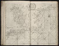
- Beinecke Rare Book and Manuscript Library > A generall chart of the West Indies
- Call Number:
- 1978 Folio 10
- Collection Title:
- The English pilot: describing the West-India navigation, from Hudson's-Bay to the river Amazones
- Image Count:
- 1
- Found in:
- Beinecke Rare Book and Manuscript Library > A generall chart of the western ocean
- Call Number:
- 1974 Folio 72
- Collection Title:
- The English pilot: describing the West-India navigation, from Hudson's-Bay to the river Amazones
- Image Count:
- 2
- Found in:
- Beinecke Rare Book and Manuscript Library > A generall chart of the western ocean
- Creator:
- Seller, John, fl. 1658-1698
- Call Number:
- 1976 Folio 139
- Collection Title:
- The English pilot: describing the sea-coasts, capes, head-lands, soundings, sands, shoals, rocks
- Image Count:
- 1
- Found in:
- Beinecke Rare Book and Manuscript Library > A large description of the two chanells in the River Dwina goeing up to the citty of Archangel by John Seller
- Call Number:
- 1973 Folio 114
- Collection Title:
- The English pilot: describing the West-India navigation, from Hudson's-Bay to the river Amazones
- Image Count:
- 1
- Resource Type:
- Maps, Atlases & Globes
- Found in:
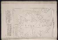
- Beinecke Rare Book and Manuscript Library > A large draft of South Carolina from Cape Roman to Port Royall
- Call Number:
- 1973 Folio 116
- Collection Title:
- The English pilot: describing the West-India navigation, from Hudson's-Bay to the river Amazones
- Image Count:
- 1
- Found in:
- Beinecke Rare Book and Manuscript Library > A large draft of South Carolina from Cape Roman to Port Royall
- Call Number:
- 1974 Folio 72
- Collection Title:
- The English pilot: describing the West-India navigation, from Hudson's-Bay to the river Amazones
- Image Count:
- 1
- Found in:
- Beinecke Rare Book and Manuscript Library > A large draft of South Carolina from Cape Roman to Port Royall
- Call Number:
- 1973 Folio 114
- Collection Title:
- The English pilot: describing the West-India navigation, from Hudson's-Bay to the river Amazones
- Image Count:
- 1
- Resource Type:
- Maps, Atlases & Globes
- Found in:
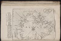
- Beinecke Rare Book and Manuscript Library > A large draft of the island Antegua
- Call Number:
- 1973 Folio 116
- Collection Title:
- The English pilot: describing the West-India navigation, from Hudson's-Bay to the river Amazones
- Image Count:
- 1
- Found in:
- Beinecke Rare Book and Manuscript Library > A large draft of the island Antegua
- Call Number:
- 1978 Folio 10
- Collection Title:
- The English pilot: describing the West-India navigation, from Hudson's-Bay to the river Amazones
- Image Count:
- 1
- Found in:
- Beinecke Rare Book and Manuscript Library > A large draft of the island Antegua
- Call Number:
- 1974 Folio 72
- Collection Title:
- The English pilot: describing the West-India navigation, from Hudson's-Bay to the river Amazones
- Image Count:
- 1
- Found in:
- Beinecke Rare Book and Manuscript Library > A large draft of the island of Antegua
- Call Number:
- 1978 Folio 10
- Collection Title:
- The English pilot: describing the West-India navigation, from Hudson's-Bay to the river Amazones
- Image Count:
- 1
- Found in:
- Beinecke Rare Book and Manuscript Library > A large draught of New England, New York, and Long Island
- Call Number:
- 1976 1233
- Collection Title:
- Forty-two new maps of Asia, Africa, and America ... : all engrav’d, according to the latest
- Image Count:
- 1
- Found in:
- Beinecke Rare Book and Manuscript Library > A map of America according to ye newest and most exact observations
- Call Number:
- 1976 1233
- Collection Title:
- Forty-two new maps of Asia, Africa, and America ... : all engrav’d, according to the latest
- Image Count:
- 1
- Found in:
- Beinecke Rare Book and Manuscript Library > A map of Brasil and part of La Plata &c
- Call Number:
- 774 B856 1820
- Container / Volume:
- BRBL_00499
- Image Count:
- 1
- Resource Type:
- Maps, Atlases & Globes
- Found in:
- Beinecke Rare Book and Manuscript Library > A map of Buck Mountain coal company mines exhibiting their relative position to the Lehigh slack water navigation and the different coal mines now opened in the region. Drawn by A.L. Foster of J. Collins 1820 (?) Lith.
- Call Number:
- Egi M6 722
- Collection Title:
- A description of the English province of Carolana, by the Spaniards call'd Florida, and by the
- Image Count:
- 1
- Found in:
- Beinecke Rare Book and Manuscript Library > A map of Carolana and of the River Meschacebe & c.
- Call Number:
- SS55 75
- Collection Title:
- The natural history of Carolina, Florida, and the Bahama Islands : containing the figures of birds
- Image Count:
- 1
- Found in:
- Beinecke Rare Book and Manuscript Library > A map of Carolina, Florida and the Bahama Islands with the adjacent parts
- Call Number:
- 1976 1233
- Collection Title:
- Forty-two new maps of Asia, Africa, and America ... : all engrav’d, according to the latest
- Image Count:
- 1
- Found in:
- Beinecke Rare Book and Manuscript Library > A map of Chili, Patagonia, part of La Plata &c
- Call Number:
- 776 1801
- Container / Volume:
- BRBL_00502
- Image Count:
- 1
- Resource Type:
- Maps, Atlases & Globes
- Found in:
- Beinecke Rare Book and Manuscript Library > A map of Delaware and eastern shore of Maryland with the soundings of the Bay of Delaware from actual survey & soundings made in 1799, 1800 & 1801 by the Author.
- Call Number:
- 1976 1233
- Collection Title:
- Forty-two new maps of Asia, Africa, and America ... : all engrav’d, according to the latest
- Image Count:
- 1
- Found in:
- Beinecke Rare Book and Manuscript Library > A map of Guinea Loango &c
- Call Number:
- 771 ON8 1797
- Container / Volume:
- BRBL_00490
- Image Count:
- 1
- Resource Type:
- Maps, Atlases & Globes
- Found in:
- Beinecke Rare Book and Manuscript Library > A map of Messrs. Gorham and Phelp's Purchase; now the County of Ontario in the State of New York From actual survey by A. Porter Engraved by A. Doolitle, New Haven.
- Call Number:
- 1976 1233
- Collection Title:
- Forty-two new maps of Asia, Africa, and America ... : all engrav’d, according to the latest
- Image Count:
- 1
- Found in:
- Beinecke Rare Book and Manuscript Library > A map of Mexico or New Spain Florida now called Louisiana and part of California &c
- Published / Created:
- undated
- Call Number:
- Vanderbilt 74
- Collection Title:
- The present state of New-England ; being a narrative of the troubles with the Indians in New
- Image Count:
- 2
- Found in:
- Beinecke Rare Book and Manuscript Library > A map of New-England, being the first that ever was here cut, and done by the best pattern that could be had, which being in some places defective, it made the other less exact, yet it doth sufficiently shew the scituation of the countrey, and convenientl
- Call Number:
- 1976 1233
- Collection Title:
- Forty-two new maps of Asia, Africa, and America ... : all engrav’d, according to the latest
- Image Count:
- 1
- Found in:
- Beinecke Rare Book and Manuscript Library > A map of Peru and the west part of the country of the Amazones
- Call Number:
- 1976 1233
- Collection Title:
- Forty-two new maps of Asia, Africa, and America ... : all engrav’d, according to the latest
- Image Count:
- 1
- Found in:
- Beinecke Rare Book and Manuscript Library > A map of South America according to ye newest and most exact observations
- Call Number:
- 1976 1233
- Collection Title:
- Forty-two new maps of Asia, Africa, and America ... : all engrav’d, according to the latest
- Image Count:
- 1
- Found in:
- Beinecke Rare Book and Manuscript Library > A map of Terra Firma, Guiana and the Antilles Islands
- Call Number:
- 1976 1233
- Collection Title:
- Forty-two new maps of Asia, Africa, and America ... : all engrav’d, according to the latest
- Image Count:
- 1
- Found in:
- Beinecke Rare Book and Manuscript Library > A map of Zaara or the Desart, Negroland & Cape Virde Islands &c
- Call Number:
- Zc20 697heg
- Collection Title:
- A new discovery of a vast country in America : extending above four thousand miles, between New
- Image Count:
- 1
- Found in:
- Beinecke Rare Book and Manuscript Library > A map of a large country newly discovered in the northern America situated between New Mexico and the frozen sea, together with the course of the Great River Meschasipi. Dedicated to His Ma.ty William III King of Great Britain. By Father Lewis Hennepin, m
- Call Number:
- Zc20 697heg
- Collection Title:
- A new discovery of a vast country in America : extending above four thousand miles, between New
- Image Count:
- 1
- Found in:
- Beinecke Rare Book and Manuscript Library > A map of a new world between New Mexico and the frozen sea newly discovered by Father Lewis Hennepin, missionary recollect and native of Aht in Hainault. Dedicated to his majesty of Great Britain William III
- Call Number:
- 1976 1233
- Collection Title:
- Forty-two new maps of Asia, Africa, and America ... : all engrav’d, according to the latest
- Image Count:
- 1
- Found in:
- Beinecke Rare Book and Manuscript Library > A map of independent Tartary containing the territories of Usbeck, Gasgar, Tibet, Lassa &c
- Call Number:
- Pequot Ad12
- Collection Title:
- The history of the American Indians; particularly those nations adjoining to the Missisippi
- Image Count:
- 1
- Found in:
- Beinecke Rare Book and Manuscript Library > A map of the American Indian nations, adjoining to the Missisippi, west & east Florida, Georgia, S. & N. Carolina, Virginia, & c
- Creator:
- Dunn, Samuel, d. 1794
- Call Number:
- 71 1776
- Container / Volume:
- BRBL_00687
- Image Count:
- 1
- Resource Type:
- Maps, Atlases & Globes
- Found in:
- Beinecke Rare Book and Manuscript Library > A map of the British Empire, in North America / by Samuel Dunn, mathematician, improved from the surveys of Capt. Carver.
- Call Number:
- 771gmb 1808
- Container / Volume:
- BRBL_00494
- Image Count:
- 1
- Resource Type:
- Maps, Atlases & Globes
- Found in:
- Beinecke Rare Book and Manuscript Library > A map of the State of New York ... including the Turnpike Roads ... By Wm. McGalpin, Oxford, 1808.
- Call Number:
- 777 C425 1799
- Container / Volume:
- BRBL_00503
- Image Count:
- 1
- Resource Type:
- Maps, Atlases & Globes
- Found in:
- Beinecke Rare Book and Manuscript Library > A map of the head of the Chesapeake Bay and Susquehanna River shewing the navigation of the same with a topographical description of the surrounding country from an actual survey by C.P. Hauducoeur 1799.
- Call Number:
- 783 1775
- Container / Volume:
- BRBL_00507
- Image Count:
- 3
- Resource Type:
- Maps, Atlases & Globes
- Found in:
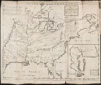
- Beinecke Rare Book and Manuscript Library > A map of the most inhabited part of Virginia part of Pensilvania, new Yersey & North Carolina.
- Call Number:
- 1977 +392
- Collection Title:
- A survey of the cities of London and Westminster : containing the original, antiquity, increase
- Image Count:
- 1
- Resource Type:
- Maps, Atlases & Globes
- Found in:
- Beinecke Rare Book and Manuscript Library > A map of the parish if St. Katherines by the Tower
- Call Number:
- 1977 +392
- Collection Title:
- A survey of the cities of London and Westminster : containing the original, antiquity, increase
- Image Count:
- 1
- Resource Type:
- Maps, Atlases & Globes
- Found in:
- Beinecke Rare Book and Manuscript Library > A map of the parish of St. Dustans Stepney and Stebunheath divided into hamlets
- Creator:
- Jefferys, Thomas, d. 1771
- Call Number:
- Z6 70
- Collection Title:
- An enquiry into the causes of the alienation of the Delaware and Shawanese Indians from the British
- Image Count:
- 1
- Found in:
- Beinecke Rare Book and Manuscript Library > A map of the province of Pensylvania. intended chiefly to illustrate the account of the several Indian purchases made by the proprietaries of the said province the claims made by the Indians, on lands settled and not purchased of them and the tract they n
- Call Number:
- 735 1790
- Container / Volume:
- BRBL_00689
- Image Count:
- 1
- Resource Type:
- Maps, Atlases & Globes
- Found in:
- Beinecke Rare Book and Manuscript Library > A map shewing the communication of the lakes and the rivers between Lake Superior and Slave Lake in North America.
- Call Number:
- 1977 +392
- Collection Title:
- A survey of the cities of London and Westminster : containing the original, antiquity, increase
- Image Count:
- 1
- Resource Type:
- Maps, Atlases & Globes
- Found in:
- Beinecke Rare Book and Manuscript Library > A mapp of the parishes of St. Clements Danes, St. Mary Savoy; with the Rolls Liberty and Lincolns Inn, taken from the last survey with corrections and additions