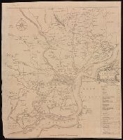
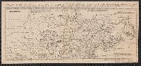
Coordinates not present on map and are approximated., From Gentleman's Magazine, vol. 23, 1753 p. 373., Includes table of distances "The distances of particular places in this map, from the court house.", and Manuscript annotation at bottom [partially trimmed].
Publisher:
[publisher not identified],
Subject (Geographic):
Philadelphia (Pa.)--Maps--Early works to 1800. and Philadelphia Region--Maps--Early works to 1800.
Subject (Name):
Heap, George, active 1715-1760
Subject (Topic):
Landowners--Pennsylvania Region--Philadelphia--Maps--Early works to 1800. and Landowners--Pennsylvania--Philadelphia--Maps--Early works to 1800.
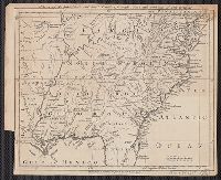
London magazine, or, Gentleman's monthly intellegencer. v. 24. July 1755.
Description:
Appears in: London magazine, or, Gentleman's monthly intelligencer. (July 1755) v.24, p. 312., Covers also part of Pennsylvania, Delaware, Louisiana, and Arkansas., Hand col. Sheet measures 64.3 x 54.8 cm. Ms. no.: 15. Cross Collection no. 184., Prime meridian: London., Relief shown by landform drawings., and Shows names of English settlements, Native territories, drainage, and other points of interest.
Publisher:
Printed for R. Baldwin ...,
Subject (Geographic):
Maryland--Maps--Early works to 1800, New Jersey--Maps--Early works to 1800, and South Atlantic States--Maps--Early works to 1800
Map of the British and French Plantations in North America.
Description:
From The London Magazine (August 1755), vol. 24, p. 360., Prime meridian: London., Relief shown pictorially., Sheet measures 22.3 x 29.1 cm. Cross Collection no. 192., and Shows New England, Maritime Provinces, and eastern Quebec.
Publisher:
London Magazine,
Subject (Geographic):
Maritime Provinces--Maps--Early works to 1800, New England--Maps--Early works to 1800, and Quebec--Maps--Early works to 1800
From Gentleman's Magazine, July 1754, opp. page 322., Imperfect: mutilated, with no loss of text. Sheet measures 24 x 29.8 cm. Cross Collection no. 183., Ornamental cartouche surrounding title., Prime meridian: London., and Relief shown pictorially.
Publisher:
Gentleman's Magazine],
Subject (Geographic):
Great Britain--Colonies--America--Maps--Early works to 1800 and United States--Maps--Early works to 1800
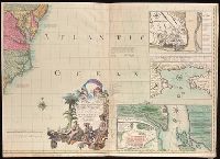
Includes text and illustrations., Insets: Plan of the town of Halifax in Nova Scotia -- Plan du port et ville de Louisbourg dans l'Isle Royale -- Plan de la ville de Quebec -- A new map of Hudsons Bay and Labrador from the late surveys of those coasts., Prime meridian: London., Relief shown pictorially., Second Dutch edition., and Sheets joined to form four separate sheets.
First edition, first issue with Millar's name and Katharine Street in imprint misspelled Miller and Katherine, respectively. Two cities in Massachusetts are named Leicester, and none is named Worcester., For a description of different editions and impressions, see the Osher Map Library (http://oshermaps.org/special-map-exhibits/mitchell-map/cartographic-notes)., Includes text and inset "A new map of Hudson's Bay and Labrador from the late survey of those coasts.", Prime meridian: London., and Relief shown pictorially.
Publisher:
Publish'd by the author Febry 13th, 1755 according to the act of Parliament, and sold by And. Miller, opposite Katherine Street in the Strand,
Subject (Geographic):
France--Colonies--America--Maps--Early works to 1800, Great Britain--Colonies--America--Maps--Early works to 1800, and North America--Maps--Early works to 1800
Subject (Name):
Kitchin, Thomas, 1718-1784 and Millar, Andrew, 1705-1768
First edition, first issue with Millar's name and Katharine Street in imprint misspelled Miller and Katherine, respectively. Two cities in Massachusetts are named Leicester, and none is named Worcester. and For a description of different editions and impressi
Publisher:
Publish'd by the author Febry 13th, 1755 according to the act of Parliament, and sold by And. Miller, opposite Katherine Street in the Strand,
Subject (Geographic):
North America--Maps--Early works to 1800
Subject (Name):
Kitchin, Thomas, 1718-1784 and Millar, Andrew, 1705-1768
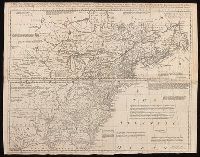
From General magazine of arts and sciences (London, England : 1755), Prime meridian: London., pt. the first. Containing Canada, Nova scotia, Newfoundland, New England, part of New York, with the Lakes, Six Nations, and all the countries westward in the same parallels so far as discover'd; exhibiting the just boundaries, and the French encroachments: laid down from authentic surveys -- pt. the second. Containing part of New York, Pensilvania, New Jersey, Mary Land, Virginia, North & South Carolina, Georgia, Louisiana, and all the countries westward in the same parellels so far as discovered, shewing the course of the Rivers Ohio, Missisipi &c. exhibiting the just boundaries & the French encroachments laid down from authentic surveys., Relief shown pictorially., Sheets pasted together to form one sheet. Watermark., and Shows boundaries, rivers, forests, principal settlements and notes.
Publisher:
[publisher not identified],
Subject (Geographic):
France--Colonies--America--Maps--Early works to 1800., Great Britain--Colonies--America--Maps--Early works to 1800., and North America--Maps--Early works to 1800.
Imperfect: 2nd part of map wanting. Mounted on linen. Sheet measures 22.4 x 49.5 cm. Cross Collection no. 151., Prime meridian: London., pt. the first. Containing Canada, Nova scotia, Newfoundland, New England, part of New York, with the Lakes, Six Nations, and all the countries westward in the same parallels so far as discover'd; exhibiting the just boundaries, and the French encroachments: laid down from authentic surveys -- pt. the second. Containing part of New York, Pensilvania, New Jersey, Mary Land, Virginia, North & South Carolina, Georgia, Louisiana, and all the countries westward in the same parellels so far as discovered, shewing the course of the Rivers Ohio, Missisipi &c. exhibiting the just boundaries & the French encroachments laid down from authentic surveys., Relief shown pictorially., and Shows boundaries, rivers, forests, principal settlements and notes.
Publisher:
s.n.,
Subject (Geographic):
France--Colonies--America--Maps--Early works to 1800, Great Britain--Colonies--America--Maps--Early works to 1800, and North America--Maps--Early works to 1800