Search
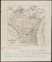
You Searched For
Search Results
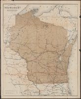
- Published / Created:
- 1882
- Call Number:
- 812 1882
- Container / Volume:
- BRBL_00555
- Image Count:
- 16
- Resource Type:
- Maps, Atlases & Globes
- Alternative Title:
- , Geological survey of Wisconsin.
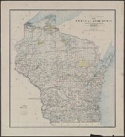
- Description:
- I & IV, Geological survey of Wisconsin.
- Subject (Geographic):
- Wisconsin--Maps
- Subject (Topic):
- Geological surveys--Wisconsin
- Found in:
- Beinecke Rare Book and Manuscript Library > Atlas of the geological survey of Wisconsin / T.C. Chamberlin, chief geologist ; R.D. Irving, Moses Strong, assistant geologists ; W.I.L. Nicodemus, topographical assistant ; T.B. Brooks ... [et al.], contributors.
- Published / Created:
- 1882
- Call Number:
- 812 1882
- Container / Volume:
- BRBL_00555
- Image Count:
- 2
- Resource Type:
- Maps, Atlases & Globes
- Alternative Title:
- , Geological survey of Wisconsin.
- Description:
- I & IV, Geological survey of Wisconsin.
- Subject (Geographic):
- Wisconsin--Maps
- Subject (Topic):
- Geological surveys--Wisconsin
- Found in:
- Beinecke Rare Book and Manuscript Library > Atlas of the geological survey of Wisconsin / T.C. Chamberlin, chief geologist ; R.D. Irving, Moses Strong, assistant geologists ; W.I.L. Nicodemus, topographical assistant ; T.B. Brooks ... [et al.], contributors.
- Creator:
- Wilson, James, Jr
- Published / Created:
- 1880
- Call Number:
- 812gbc 1880
- Container / Volume:
- BRBL_00556
- Image Count:
- 1
- Resource Type:
- Maps, Atlases & Globes
- Description:
- Wisconsin and the surrounding region.
- Publisher:
- Wisconsin Geological Survey,
- Subject (Name):
- Wisconsin. Geological Survey
- Subject (Topic):
- Lead mines and mining--Wisconsin--Maps
- Found in:
- Beinecke Rare Book and Manuscript Library > General map of the lead region showing the distribution of the lodes / by James Wilson, Jr.
- Published / Created:
- 1911
- Call Number:
- 812 1911
- Container / Volume:
- BRBL_00555A
- Image Count:
- 1
- Resource Type:
- Maps, Atlases & Globes
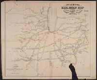
- Description:
- List of Wisconsin railroads.
- Subject (Geographic):
- Wisconsin--Maps
- Found in:
- Beinecke Rare Book and Manuscript Library > Wisconsin.
- Published / Created:
- 1902
- Call Number:
- 812 1902
- Container / Volume:
- BRBL_00555A
- Image Count:
- 1
- Resource Type:
- Maps, Atlases & Globes
- Description:
- List of Wisconsin railroads.
- Subject (Geographic):
- Wisconsin--Maps
- Found in:
- Beinecke Rare Book and Manuscript Library > Wisconsin.
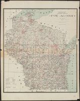
- Published / Created:
- 1882
- Call Number:
- 812 1882
- Container / Volume:
- BRBL_00555
- Image Count:
- 27
- Resource Type:
- Maps, Atlases & Globes
- Alternative Title:
- , Geological survey of Wisconsin.
- Description:
- I & IV, Geological survey of Wisconsin.
- Subject (Geographic):
- Wisconsin--Maps
- Subject (Topic):
- Geological surveys--Wisconsin
- Found in:
- Beinecke Rare Book and Manuscript Library > Atlas of the geological survey of Wisconsin / T.C. Chamberlin, chief geologist ; R.D. Irving, Moses Strong, assistant geologists ; W.I.L. Nicodemus, topographical assistant ; T.B. Brooks ... [et al.], contributors.
- Published / Created:
- 1886
- Call Number:
- 812 1886
- Container / Volume:
- BRBL_00555A
- Image Count:
- 1
- Resource Type:
- Maps, Atlases & Globes
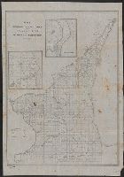
- Description:
- Shows Wisconsin Central Railway in red.
- Subject (Geographic):
- Wisconsin--Maps
- Subject (Topic):
- Railroads--Wisconsin--Maps
- Found in:
- Beinecke Rare Book and Manuscript Library > Wisconsin Central line.
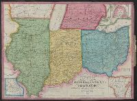
- Published / Created:
- 1843
- Call Number:
- 811 1843
- Container / Volume:
- BRBL_00552
- Image Count:
- 1
- Resource Type:
- Maps, Atlases & Globes
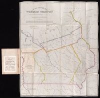
- Description:
- Insets: 1. Missouri 2. Wisconsin Tery.
- Found in:
- Beinecke Rare Book and Manuscript Library > Traveller's map of Michigan, Indiana & Ohio.
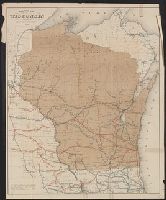
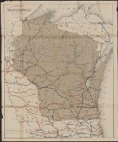
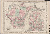
- Creator:
- Wisconsin Geological and Natural History Survey
- Published / Created:
- 1877-1882
- Call Number:
- 812gbc 1876
- Container / Volume:
- BRBL_00556
- Image Count:
- 7
- Resource Type:
- Maps, Atlases & Globes
- Alternative Title:
- Wisconsin.
- Description:
- Accompanies: Geology of Wisconsin
- Publisher:
- Wisconsin Geological Survey,
- Subject (Geographic):
- Wisconsin--Maps
- Subject (Topic):
- Geology--Wisconsin--Maps
- Found in:
- Beinecke Rare Book and Manuscript Library > Atlas of the geological survey of Wisconsin / T.C. Chamberlin, chief geologist ; R.D. Irving, Moses Strong, assistant geologists ; W.I.L. Nicodemus, topographical assistant ; T.B. Brooks ... [et al.], special contributors.
- Published / Created:
- 1856
- Call Number:
- 812gme 1856
- Container / Volume:
- BRBL_00556
- Image Count:
- 1
- Resource Type:
- Maps, Atlases & Globes
- Description:
- Includes Wisconsin, Minnesota, and
- Subject (Geographic):
- Wisconsin--Maps
- Found in:
- Beinecke Rare Book and Manuscript Library > Map of the Lacrosse & Milwaukee railroad and connections.
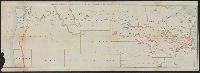
- Creator:
- Railroad Commission of Wisconsin
- Published / Created:
- 1880
- Call Number:
- 812gme 1880
- Container / Volume:
- BRBL_00556
- Image Count:
- 1
- Resource Type:
- Maps, Atlases & Globes
- Subject (Geographic):
- Wisconsin--Maps
- Subject (Topic):
- Railroads--Wisconsin--Maps
- Found in:
- Beinecke Rare Book and Manuscript Library > Railroad map of Wisconsin / prepared for the railroad commissioner.
- Creator:
- Milwaukee Lith. & Engr. Co.
- Published / Created:
- [1873?]
- Call Number:
- BrSides 2018 157
- Image Count:
- 1
- Resource Type:
- Maps, Atlases & Globes
- Subject (Geographic):
- Wisconsin
- Found in:
- Beinecke Rare Book and Manuscript Library > Map of Wisconsin : prepared for the legislative manual from offical records, 1873.
- Creator:
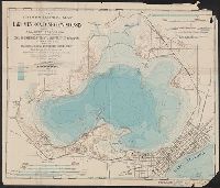
- Wisconsin. Geological and natural history survey
- Published / Created:
- 1900]
- Call Number:
- 812ceh M523 1900
- Container / Volume:
- BRBL_00556
- Image Count:
- 1
- Resource Type:
- Maps, Atlases & Globes
- Subject (Name):
- Wisconsin. University
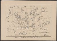
- Subject (Topic):
- Hydrography--United States--Wisconsin
- Found in:
- Beinecke Rare Book and Manuscript Library > Hydrographic map of Lake Mendota, Dane Co., Wisconsin, and of its adjacent topography, prepared from surveys made by civil engineering students, University of Wisconsin, classes 1897, 8, 9, 0 and by the Wisconsin Geological and natural survey / E. A. Birg
- Creator:
- Poole Brothers
- Published / Created:
- c1906.
- Call Number:
- 812 1906
- Container / Volume:
- BRBL_00555A
- Image Count:
- 1
- Resource Type:
- Maps, Atlases & Globes
- Subject (Geographic):
- Wisconsin--Maps
- Subject (Topic):
- Railroads--Wisconsin--Maps
- Found in:
- Beinecke Rare Book and Manuscript Library > Map of Wisconsin.
- Creator:
- Rand McNally and Company
- Published / Created:
- [1912]
- Call Number:
- 80gme 1912B
- Container / Volume:
- BRBL_00540
- Image Count:
- 1
- Resource Type:
- Maps, Atlases & Globes
- Description:
- , Illinois and Wisconsin.
- Found in:
- Beinecke Rare Book and Manuscript Library > Outline map of the lines of the Chicago, Milwaukee & St. Paul Railway Company, Chicago, Milwaukee & Puget Sound Railway Company, and Tacoma Eastern Railway Company : June 30, 1912.
- Creator:
- Lapham, Charles A., 1857-1935
- Published / Created:
- 1888
- Call Number:
- 812 Oc5 1888
- Container / Volume:
- BRBL_00555A
- Image Count:
- 1
- Resource Type:
- Maps, Atlases & Globes
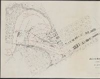
- Alternative Title:
- Oconomowoc & Waukesha, Waukesha County, Wisconsin
- Subject (Topic):
- Lakes--Wisconsin--Oconomowoc--Maps
- Found in:
- Beinecke Rare Book and Manuscript Library > Map of the lakes & drives in the vicinity of Oconomowoc & Waukesha, Waukesha County, Wisconsin / drawn by Chas. Lapham.
- Published / Created:
- 1883
- Call Number:
- 812gme 1883
- Container / Volume:
- BRBL_00556
- Image Count:
- 1
- Resource Type:
- Maps, Atlases & Globes
- Subject (Topic):
- Railroads--Wisconsin--Maps
- Found in:
- Beinecke Rare Book and Manuscript Library > Railroad map of Wisconsin / prepared for the railroad commissioner.
- Creator:
- Conover, Allan D
- Published / Created:
- 1881
- Call Number:
- 812gme 1881
- Container / Volume:
- BRBL_00556
- Image Count:
- 1
- Resource Type:
- Maps, Atlases & Globes
- Subject (Topic):
- Railroads--Wisconsin--Maps
- Found in:
- Beinecke Rare Book and Manuscript Library > Railroad map of Wisconsin / prepared for the railroad commissioner by Allan D. Conover C.E.
- Creator:
- Kramm, Gustavus
Lea, Albert Miller, 1808-1891
Lehman & Duval Lithrs
- Published / Created:
- 1935
- Call Number:
- Zc29 836Leb
- Image Count:
- 1
- Description:
- original: Notes on Wisconsin territory ... by
- Subject (Geographic):
- Wisconsin--Description and travel
- Found in:
- Beinecke Rare Book and Manuscript Library > The book that gave to Iowa its name, a reprint.
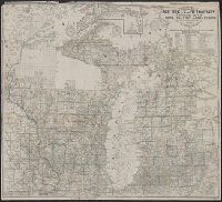
- Creator:
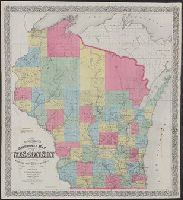
- Johnson, A. J. (Alvin Jewett), 1827-1884
- Published / Created:
- [1866]
- Call Number:
- 812 1866
- Container / Volume:
- BRBL_00555
- Image Count:
- 2
- Resource Type:
- Maps, Atlases & Globes
- Alternative Title:
- Wisconsin and Michigan
- Subject (Geographic):
- Wisconsin--Maps
- Subject (Topic):
- Counties--Wisconsin--Maps
- Found in:
- Beinecke Rare Book and Manuscript Library > Johnson's Wisconsin and Michigan.
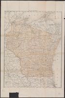
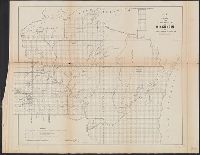
- Creator:
- United States. General Land Office
- Published / Created:
- 1878
- Call Number:
- 812 1878
- Container / Volume:
- BRBL_00555
- Image Count:
- 1
- Resource Type:
- Maps, Atlases & Globes
- Subject (Geographic):
- Wisconsin--Maps
- Found in:
- Beinecke Rare Book and Manuscript Library > State of Wisconsin / Department of the Interior, General Land Office, J.A. Williamson, commissioner ; compiled from the official records of the General Land Office and other sources by C. Roeser, Principal Draughtsman, G.L.O.
- Creator:
- G.W. & C.B. Colton & Co
- Published / Created:
- 1872
- Call Number:
- 80gme 1872
- Container / Volume:
- BRBL_00539
- Image Count:
- 1
- Resource Type:
- Maps, Atlases & Globes
- Description:
- Wisconsin to southern Kansas, Missouri, and
- Found in:
- Beinecke Rare Book and Manuscript Library > Colton's railroad and express map of the northwestern states : showing the counties, towns, railroads, station, distances, etc.
- Creator:
- Suydam, John V
- Published / Created:
- 1836]
- Call Number:
- 812 M265 1836
- Container / Volume:
- BRBL_00555A
- Image Count:
- 1
- Resource Type:
- Maps, Atlases & Globes
- Subject (Topic):
- Real property--Wisconsin--Madison--Maps
- Found in:
- Beinecke Rare Book and Manuscript Library > Plat of Madison, the capital of Wisconsin 1836. John V. Suydam, distr. surveyor.
- Published / Created:
- 1897
- Call Number:
- 812 1897
- Container / Volume:
- BRBL_00555A
- Image Count:
- 2
- Resource Type:
- Maps, Atlases & Globes
- Description:
- Shows Wisconsin Central Railway in red
- Subject (Geographic):
- Wisconsin--Maps
- Found in:
- Beinecke Rare Book and Manuscript Library > The Matthews-Northrup up-to-date map of Wisconsin : published indexed in vest-pocket style.
- Creator:
- Chapman, Silas
- Published / Created:
- 1857
- Call Number:
- 812 1857
- Container / Volume:
- BRBL_00555
- Image Count:
- 1
- Resource Type:
- Maps, Atlases & Globes
- Description:
- State of Wisconsin."
- Subject (Geographic):
- Wisconsin--Maps
- Found in:
- Beinecke Rare Book and Manuscript Library > Chapman's sectional map of Wisconsin [cartographic material] : with the most recent surveys.
- Creator:
- Rand McNally and Company
- Published / Created:
- 1879
- Call Number:
- 811 1879
- Container / Volume:
- BRBL_00552
- Image Count:
- 1
- Resource Type:
- Maps, Atlases & Globes
- Description:
- adjacent parts of Wisconsin, Illinois, Indiana
- Found in:
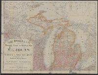
- Beinecke Rare Book and Manuscript Library > Rand, McNally & Co.'s township, county and railroad map of Michigan and the entire Upper Lake Region : showing the celebrated mining districts of the Upper Peninsula / compiled from the U.S. Land Office and Lake Surveys, County Surveys, etc.
- Published / Created:
- [1847]
- Call Number:
- 812fcm 1847
- Container / Volume:
- BRBL_00556
- Image Count:
- 1
- Resource Type:
- Maps, Atlases & Globes
- Subject (Geographic):
- Wisconsin--Maps
- Found in:
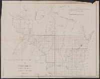
- Beinecke Rare Book and Manuscript Library > Sketch of the Public Surveys in Wisconsin
- Creator:
- United States. Surveyor General
- Published / Created:
- 1850
- Call Number:
- 812fcm 1850
- Container / Volume:
- BRBL_00556
- Image Count:
- 1
- Resource Type:
- Maps, Atlases & Globes
- Subject (Geographic):
- Wisconsin--Maps
- Found in:
- Beinecke Rare Book and Manuscript Library > Public surveys in the state of Wisconsin and territory of Minnesota.
- Creator:
- United States. Army. Corps of Engineers
- Published / Created:
- 1940
- Call Number:
- 814 M666 1940
- Container / Volume:
- BRBL_00558
- Image Count:
- 1
- Resource Type:
- Maps, Atlases & Globes
- Description:
- and Wisconsin.
- Subject (Geographic):
- Wisconsin--Maps
- Subject (Topic):
- Transportation--Wisconsin--Maps
- Found in:
- Beinecke Rare Book and Manuscript Library > Strategic map [of the United States]. Twin Cities sheet.
- Creator:
- G.W. & C.B. Colton & Co
- Published / Created:
- [between 1857 and 1877?]
- Call Number:
- 80gme 1877
- Container / Volume:
- BRBL_00539
- Image Count:
- 1
- Resource Type:
- Maps, Atlases & Globes
- Description:
- Wisconsin.
- Subject (Topic):
- Railroads--Wisconsin--Maps
- Found in:
- Beinecke Rare Book and Manuscript Library > Map of the Southern Minnesota Railroad and its connections.
- Creator:
- Chapman, Silas
- Published / Created:
- 1855
- Call Number:
- 814 1855B
- Container / Volume:
- BRBL_00557
- Image Count:
- 1
- Resource Type:
- Maps, Atlases & Globes
- Description:
- and Trempeleau counties in Wisconsin in
- Found in:
- Beinecke Rare Book and Manuscript Library > Sectional map of Minnesota.
- Creator:
- Rand McNally and Company
- Published / Created:
- 1899
- Call Number:
- 80gme 1899
- Container / Volume:
- BRBL_00539
- Image Count:
- 1
- Resource Type:
- Maps, Atlases & Globes
- Description:
- , Wisconsin, Nebraska, Iowa, Illinois, and
- Found in:
- Beinecke Rare Book and Manuscript Library > Chicago, Burlington & Quincy railroad system.
- Creator:
- Wells, John G. (John Gaylord), 1821-1880
- Published / Created:
- 1857
- Call Number:
- 825 1857B
- Container / Volume:
- BRBL_00573
- Image Count:
- 1
- Resource Type:
- Maps, Atlases & Globes
- Description:
- Minnesota, Wisconsin, Iowa, Illinois, Missouri
- Found in:
- Beinecke Rare Book and Manuscript Library > Kansas & Nebraska.
- Published / Created:
- 1897
- Call Number:
- 812gmb M648 1897
- Container / Volume:
- BRBL_00556
- Image Count:
- 1
- Resource Type:
- Maps, Atlases & Globes
- Subject (Geographic):
- Milwaukee (Wisconsin)--Maps
- Found in:
- Beinecke Rare Book and Manuscript Library > Wright's map of Milwaukee.
- Creator:
- United States. General Land Office
- Published / Created:
- 1896
- Call Number:
- 812 1896
- Container / Volume:
- BRBL_00555A
- Image Count:
- 1
- Resource Type:
- Maps, Atlases & Globes
- Subject (Geographic):
- Wisconsin--Administrative and political
- Found in:
- Beinecke Rare Book and Manuscript Library > Map of the state of Wisconsin / Department of the Interior, General Land Office ; compiled from the official records of the General Land Office and other sources under the direction of Harry King, C.E., chief of Drafting Division G.L.O. ; compiled, drawn
- Creator:
- Colton, G. Woolworth (George Woolworth), 1827-1901
- Published / Created:
- 1862
- Call Number:
- 754gme 1860A
- Container / Volume:
- BRBL_00420
- Image Count:
- 1
- Resource Type:
- Maps, Atlases & Globes
- Alternative Title:
- map of Wisconsin, Illinois, Missouri
- Description:
- Wisconsin; Appleton is the northernmost town on
- Subject (Geographic):
- Wisconsin--Maps
- Subject (Topic):
- Railroads--Wisconsin--Maps
- Found in:
- Beinecke Rare Book and Manuscript Library > Colton's county and township rail road map of Wisconsin, Illinois, Missouri, & Iowa / Drawn, engraved & published by G. Woolworth Colton
- Creator:
- Kramm, Gustavus
Lea, Albert Miller, 1808-1891
Lehman & Duval Lithrs
- Published / Created:
- 1836
- Call Number:
- Zc29 836Le
- Image Count:
- 1
- Description:
- Cover title: Notes on the Wisconsin
- Subject (Geographic):
- Wisconsin--Description and travel
- Found in:
- Beinecke Rare Book and Manuscript Library > Notes on Wisconsin Territory : with a map / by Lieutenant Albert M. Lea.
- Creator:
- Surveyor General of Iowa, Wisconsin, and Minnesota
- Published / Created:
- 1855
- Call Number:
- 812 1855C
- Container / Volume:
- BRBL_00555
- Image Count:
- 1
- Resource Type:
- Maps, Atlases & Globes
- Alternative Title:
- Wisconsin and territory of Minnesota.
- Subject (Geographic):
- Wisconsin--Maps
- Found in:
- Beinecke Rare Book and Manuscript Library > Sketch of the public surveys in Wisconsin and territory of Minnesota.
- Creator:
- Burr, David H., 1803-1875
- Published / Created:
- [1839?]
- Call Number:
- 811 1839A
- Container / Volume:
- BRBL_00552
- Image Count:
- 4
- Resource Type:
- Maps, Atlases & Globes
- Alternative Title:
- Map of Michigan and part of Wisconsin
- Subject (Geographic):
- Wisconsin--Maps
- Found in:
- Beinecke Rare Book and Manuscript Library > Map of Michigan & part of Wisconsin Territory : exhibiting the post offices, post roads, canals, rail roads, &c. / by David H. Burr.
- Published / Created:
- 1915
- Call Number:
- 812ag 1915
- Container / Volume:
- BRBL_00556
- Image Count:
- 2
- Resource Type:
- Maps, Atlases & Globes
- Alternative Title:
- northwestern Wisconsin
- Description:
- northern Wisconsin and Michigan, reached by the
- Subject (Geographic):
- Wisconsin--Maps
- Found in:
- Beinecke Rare Book and Manuscript Library > Hunting and fishing resorts of northern Wisconsin and Michigan : reached by the Chicago and North Western Railway.
- Creator:
- United States. Surveyor General
- Published / Created:
- 1860
- Call Number:
- 812fcm 1860
- Container / Volume:
- BRBL_00556
- Image Count:
- 1
- Resource Type:
- Maps, Atlases & Globes
- Alternative Title:
- Wisconsin and territory of Minnesota.
- Subject (Geographic):
- Wisconsin--Maps
- Found in:
- Beinecke Rare Book and Manuscript Library > Sketch of the public surveys in the state of Wisconsin and territory of Minnesota.
- Published / Created:
- [1860?]
- Call Number:
- 812 M265 1860
- Container / Volume:
- BRBL_00555A
- Image Count:
- 1
- Resource Type:
- Maps, Atlases & Globes
- Found in:
- Beinecke Rare Book and Manuscript Library > Madison, the capitol of Wisconsin.
- Creator:
- Farmer, John, 1798-1859
- Published / Created:
- 1857
- Call Number:
- 754 1857
- Container / Volume:
- BRBL_00416
- Image Count:
- 1
- Resource Type:
- Maps, Atlases & Globes
- Alternative Title:
- Township map of Michigan and Wisconsin.
- Subject (Geographic):
- Wisconsin--Maps
- Found in:
- Beinecke Rare Book and Manuscript Library > Farmer's township map of Michigan and Wisconsin : embracing part of Iowa Illinois and Minnesota, with a chart of the lakes / prepared engraved and published by the author at Detroit.
- Published / Created:
- 1852?]
- Call Number:
- 811gme 1852
- Container / Volume:
- BRBL_00554
- Image Count:
- 1
- Resource Type:
- Maps, Atlases & Globes
- Description:
- , Wisconsin, Michigan, New York; and parts of
- Found in:
- Beinecke Rare Book and Manuscript Library > Map of Michigan Southern, Northern Indiana and Chicago and Rock Island railroads : with their connections from Council Bluffs to New York / lith. by F. Michelin & Geo. Leefe.
- Creator:
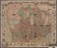
- Owen, David Dale, 1807-1860
- Published / Created:
- between 1844 and 1899?]
- Call Number:
- 815ca 1890
- Container / Volume:
- BRBL_00561
- Image Count:
- 1
- Resource Type:
- Maps, Atlases & Globes
- Subject (Topic):
- Geology--Wisconsin--Maps
- Found in:
- Beinecke Rare Book and Manuscript Library > Geological chart of part of Iowa, Wisconsin, and Illinois / by D.D. Owen.
- Published / Created:
- 1887
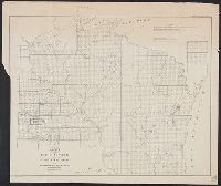
- Call Number:
- 812 As31 1887
- Container / Volume:
- BRBL_00555A
- Image Count:
- 1
- Resource Type:
- Maps, Atlases & Globes
- Found in:
- Beinecke Rare Book and Manuscript Library > Map of Ashland county Wisconsin : Corrected to February 1887.
- Creator:
- Drake, Ira S
- Published / Created:
- 1850, c1849.
- Call Number:
- 754 1850
- Container / Volume:
- BRBL_00416
- Image Count:
- 1
- Resource Type:
- Maps, Atlases & Globes
- Alternative Title:
- , Iowa, and Wisconsin
- Found in:
- Beinecke Rare Book and Manuscript Library > Map of the states of Missouri, Illinois, Iowa and Wisconsin : the territory of Minnesota, and the mineral lands of Lake Superior / compiled by I.S. Drake ; engraved by Ira S. Drake and J.L. Hazzard.
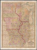
- Creator:
- Atwood, John M., b. ca. 1818
- Published / Created:
- 1848
- Call Number:
- 80 1848C
- Container / Volume:
- BRBL_00533
- Image Count:
- 1
- Resource Type:
- Maps, Atlases & Globes
- Alternative Title:
- , Illinois, Missouri, Iowa, and Wisconsin.
- Description:
- , and Wisconsin; with railroad, canal, stage
- Found in:
- Beinecke Rare Book and Manuscript Library > Map of the western states / drawn & engraved by J.M. Atwood.
- Creator:
- Chapman, Silas
- Published / Created:
- 1859
- Call Number:
- 754gme 1859
- Container / Volume:
- BRBL_00420
- Image Count:
- 1
- Resource Type:
- Maps, Atlases & Globes
- Found in:
- Beinecke Rare Book and Manuscript Library > Chapman's rail road map of Ohio, Indiana, Michigan, Illinois, Missouri, Minnesota, & Wisconsin.
- Published / Created:
- [1840?]
- Call Number:
- 806 1840
- Container / Volume:
- BRBL_00547
- Image Count:
- 1
- Resource Type:
- Maps, Atlases & Globes
- Found in:
- Beinecke Rare Book and Manuscript Library > Map of Northern part of Illinois and the surveyed part of Wisconsin Territory.
- Published / Created:
- 1844
- Call Number:
- 755 1844
- Container / Volume:
- BRBL_00441
- Image Count:
- 1
- Resource Type:
- Maps, Atlases & Globes
- Found in:
- Beinecke Rare Book and Manuscript Library > Guide through Ohio, Michigan, Indiana, Illinois, Missouri, Wisconsin & Iowa by J. Calvin Smith ...
- Published / Created:
- [1855]
- Call Number:
- 812 M265 1855
- Container / Volume:
- BRBL_00555A
- Image Count:
- 1
- Resource Type:
- Maps, Atlases & Globes
- Found in:
- Beinecke Rare Book and Manuscript Library > Madison - the capital of Wisconsin. Map of Madison and the Four Lance Country, Dane Co. Wis.
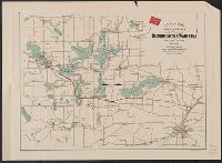
- Creator:
- Lapham, Charles A., 1857-1935
- Published / Created:
- [1874?]
- Call Number:
- 812 Oc5 1890
- Container / Volume:
- BRBL_00555A
- Image Count:
- 1
- Resource Type:
- Maps, Atlases & Globes
- Found in:
- Beinecke Rare Book and Manuscript Library > Map of the lakes & drives around Oconomowoc, Wisconsin : a favorite summer resort / [drawn by Chas. Lapham].
- Published / Created:
- 1896
- Call Number:
- 812 M314 1896
- Container / Volume:
- BRBL_00555A
- Image Count:
- 2
- Resource Type:
- Maps, Atlases & Globes
- Found in:
- Beinecke Rare Book and Manuscript Library > Manitowoc, Wisconsin : showing the harbor lines approved by the Secretary of War on February 11th 1896 also the new terminals of the Milwaukee and Lake Winnebago Railroad Company 1896.
- Published / Created:
- 1860]
- Call Number:
- 806gme 1860A
- Container / Volume:
- BRBL_00549
- Image Count:
- 1
- Resource Type:
- Maps, Atlases & Globes
- Found in:
- Beinecke Rare Book and Manuscript Library > Map of the Jacksonville & Carrollton Rail Road : showing its connection with St. Louis & Alton and with Iowa, Wisconsin & the northern parts of Illinois and Missouri / drawn & compiled by F.L. Hillebrand, Civ. Engineer.