Also shows Amerindian reservations: Cayuga Reservation -- Onondago Reservation -- Oneida Reservation., Imperfect: mutilated. Backed with paper., Includes note describing the numbering of military-township lots., and Shows property tract boundaries, town (militar
Publisher:
[publisher not identified],
Subject (Geographic):
New York (State)--Administrative and political divisions--Maps--Early works to 1800, New York (State)--Upstate New York, and Upstate New York (N.Y.)--Administrative and political divisions--Maps--Early works to 1800
Subject (Name):
Tiebout, Cornelius, 1777-1832
Subject (Topic):
Administrative and political divisions, Indian reservations--New York (State)--Maps--Early works to 1800., Landowners--New York (State)--Maps--Early works to 1800., and Landowners--New York (State)--Upstate New York--Maps--Ear
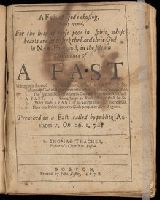
BEIN Pequot T34: Imperfect: title-border repaired., BEIN Pequot Z96: Imperfect: some head-lines bled; title-page and following leaf scorched, but without loss of text. Number 2 of 6 titles bound together in brown, blind tooled leather binding with manuscript call number label on spine., and Signatures: A-D⁴.
Publisher:
Printed by John Foster
Subject (Topic):
Fast-day sermons, Congregational churches, Sermons, American, and Sermons pour les jours de jeûne
Covers Nova Scotia, New Brunswick, Prince Edward Island, and part of Quebec., Includes text in lower margin., Manuscript note at bottom below price, "Plain or Coloud.", Prime meridian: London., and Relief shown pictorially.
Publisher:
Publish'd according to Act of Parlian't Apr'l 21st, 1749, by Ino. Gibson engraver in Bartlet Street Clerkenwell & sold by the printsellers in London & Westminster,
Subject (Geographic):
Acadia--Maps--Early works to 1800., Maritime Provinces--Maps--Early works to 1800., North America--Acadia, and Québec (Province)--Maps--Early works to 1800.
Navigantium atque itinerantium bibliotheca ; Or, A complete collection of voyages and travels
Image Count:
1
Resource Type:
Maps, Atlases & Globes
Alternative Title:
New and accurate map of China
Description:
From: Navigantium atque itinerantium bibliotheca, or, A complete collection of voyages and travels / originally published in two volumes in folio, by John Harris. London : Printed for T. Osborne [and others], 1764., In upper right margin: Vol. II. Page 961., Map of China showing provincial divisions. Relief shown pictorially., Prime meridian: London., and Watermark.
Publisher:
[Printed for T. Osborne],
Subject (Geographic):
China--Maps--Early works to 1800.
Subject (Name):
Harris, John, 1667?-1719. Navigantium atque itinerantium bibliotheca.
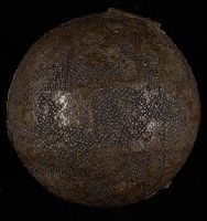
BEIN Globe 45: From the library of Stephen F. Gates. Accompanied by display plate., Terrestrial pocket globe showing the tracks of Anson's voyage, 1740-1744. Australia is drawn according to the Dutch discoveries and named New Holland., and Wooden spherical case in two parts covered with black sharkskin and lined with celestial maps of the northern and southern sky.
Publisher:
N. Hill?
Subject (Name):
Anson, George Anson, Baron, 1697-1762 and Anson, George Anson, Baron, 1697-1762.
Page 155. New London spy, or, A twenty-four hours ramble through the bills of mortality.
Image Count:
1
Resource Type:
still image
Abstract:
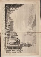
View on George Street, looking towards the square, St. George's Church on the right with large Corinthian portico, fat farmer driving sheep in street at center, sedan chair to right
Alternative Title:
View of Saint Georges Church, Hanover Square, from Conduit Street, London and Vuë de l'Eglise de Saint George dans le Carré de Hanover, prés du Côté Rue Conduit à Londres
Description:
Titles engraved below image, in English and French., Titled 'View of St. George's Church, Hannover Square, published by Jefferys' in the Catalogue of Maps, Prints, Drawings, etc., forming the geographical and topographical collection attached to the Library of his late Majesty King George the third, etc, London, 1829., Date range for publication based on publisher's street address and death date; Thomas Jefferys moved to the corner of Charing Cross in 1750 and died in 1771. See British Museum online catalogue., "Publish'd according to act of Parliamt."--Below image., For a variant state published by John Boydell, see British Museum online catalogue, registration no.: 1880,1113.4534., Title in English and French, with publication line in English., Folded to 30.2 x 25.5 cm., and Tipped in at page 155 in a copiously extra-illustrated copy of: King, R. The new London spy, or, A twenty-four hours ramble through the bills of mortality. London : Printed for J. Cooke [and 3 others], [1771?].
Publisher:
Printed for T. Jefferys, the corner of St. Martins Lane, Charing Cross
Subject (Geographic):
England, London, London (England), and London.
Subject (Name):
St. George's Church (Westminster, London, England),
Subject (Topic):
Church buildings, Plazas, Churches, City & town life, Sedan chairs, and Herders
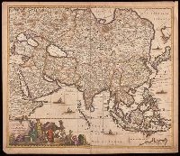
Appears in various editions of Wit's Atlas., Hand colored in outline., Imperfect: chipped and torn along edges, with no loss of text. Backed with paper., Map of Asia from Saudi Arabia, Russia, India, China, Japan to Southeast Asia., Number "4" in upper right corner., and Relief shown pictorially.
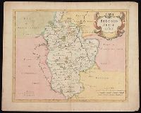
First state, produced prior to changes before 1722., From: Camden's Britannia, newly translated into English ... [London] : Printed by F. Collins, for A. Swalle ... and A. & J. Churchil ..., 1695., London meridian., Relief shown pictorially., and Shows boundaries, rivers, roads, woods, parks and settlements.
Publisher:
Sold by Abel Swale, Awnsham & Iohn Churchil,
Subject (Geographic):
Bedfordshire (England)--Maps--Early works to 1800.
Subject (Name):
Camden, William, 1551-1623. Britannia. English., Churchill, Awnsham, -1728, Churchill, John, active 1690-1714, and Swall, Abel
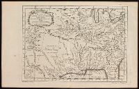
Shows topographic features, locations of forts and missions and Native American inhabitation.
Description:
In French., Relief shown pictorially., Removed from Jean-Francois de La Harpe's Abrege de l'historie générale des voyages par La Harpe with page numbers Tom XIV., and Watermark.
Publisher:
[Jean-Francois de La Harpe],
Subject (Geographic):
Florida--Maps--Early works to 1800., Louisiana--Maps--Early works to 1800., and North America--Maps--Early works to 1800
Subject (Name):
La Harpe, Jean-François de, 1739-1803. Abrege de l'historie générale des voyages.