Search
You Searched For
Search Results
- Published / Created:
- Decemr. 1766.
- Call Number:
- 732cea 1766
- Container / Volume:
- BRBL_00377
- Image Count:
- 1
- Resource Type:
- Maps, Atlases & Globes
- Publisher:
- the Author,
- Found in:
- Beinecke Rare Book and Manuscript Library > A draught of the harbour of Hallifax, and the adjacent coast in Nova Scotia / survey'd by order of Commodore Spry by James Cook, when master of His Majesty's ship the Mars ; Emanl. Bowen, sculpt.
- Creator:
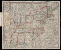
- Tanner, Henry Schenck, 1786-1858
- Published / Created:
- 1839
- Call Number:
- CE158 T35 1839
- Collection Title:
- The American traveller; or, Guide through the United States
- Image Count:
- 1
- Resource Type:
- Maps, Atlases & Globes
- Publisher:
- The author
- Found in:
- Beinecke Rare Book and Manuscript Library > The Travellers Guide or Map of the Roads, Canals and Railroads of the United States with distances from place to place
- Creator:
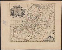
- Mortier, Pierre, author
- Call Number:
- 51 1705
- Container / Volume:
- BRBL_00278
- Image Count:
- 1
- Resource Type:
- Maps, Atlases & Globes
- Found in:
- Beinecke Rare Book and Manuscript Library > Carte de la Terre Sainte : divisée selon les douze tribus d'Isreal ou sont exactement marquez les voyages de Iésus Christ &c. : dressée pour bien entendre les histoires de la Bible / par le sain de Pierre Mortier ; I. van Luchtenburg delin. et schulp.
- Creator:
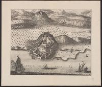
- Mortier, Pierre, author
- Call Number:
- 462 1721
- Container / Volume:
- BRBL_00260
- Image Count:
- 1
- Resource Type:
- Maps, Atlases & Globes
- Found in:
- Beinecke Rare Book and Manuscript Library > Castell-novo : aux Venetiens dans le Dalmatie / par Pierre Mortier.
- Creator:
- Hausermann, R., author.
- Published / Created:
- [1877]
- Call Number:
- BrSides 2019 88
- Image Count:
- 1
- Resource Type:
- Maps, Atlases & Globes
- Found in:
- Beinecke Rare Book and Manuscript Library > Plan de Saint Louis (Sénégal) : d'après les cartes hydrographiques de la Marine / dressée par R. Hausermann.
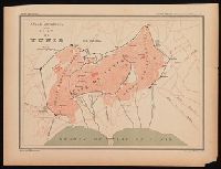
- Creator:
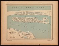
- Hausermann, R., author.
- Published / Created:
- [1877]
- Call Number:
- BrSides 2019 89
- Image Count:
- 1
- Resource Type:
- Maps, Atlases & Globes
- Found in:
- Beinecke Rare Book and Manuscript Library > Plan de Tunis / dressée par R. Hausermann.
- Creator:
- Russia. Gidrograficheskīĭ departament, author
- Call Number:
- 23cea 1858
- Container / Volume:
- BRBL_00021
- Image Count:
- 1
- Resource Type:
- Maps, Atlases & Globes
- Found in:
- Beinecke Rare Book and Manuscript Library > Karta Ledovitago mori︠a︡ i Vostochnago okeana / sostavlena s novi︠e︡ĭshikh opiseĭ v Geograficheskom departamenti︠e︡ Morskago ministerstva.
- Creator:
- Letts, Son & Co., author
- Published / Created:
- [1882?]
- Call Number:
- 32 L84 1881
- Container / Volume:
- BRBL_00051
- Image Count:
- 1
- Resource Type:
- Maps, Atlases & Globes
- Found in:
- Beinecke Rare Book and Manuscript Library > Letts's map of London [cartographic material].
- Creator:
- Price & Lee Co., author
- Call Number:
- 766 N46 1880B
- Container / Volume:
- BRBL_00472
- Image Count:
- 2
- Resource Type:
- Maps, Atlases & Globes
- Found in:
- Beinecke Rare Book and Manuscript Library > Price, Lee & Co. new map of the City of New Haven / surveyed by S.W. Searle, surveyor and civil engineer and drawn by him expressly for their new city directory.
- Creator:
- Chatelain, Henri Abraham, author
- Call Number:
- 653 L71 1719
- Container / Volume:
- BRBL_00343
- Image Count:
- 1
- Resource Type:
- Maps, Atlases & Globes
- Found in:
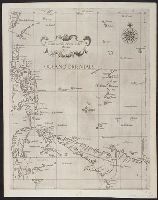
- Beinecke Rare Book and Manuscript Library > Vue & description de la ville de Lovango dans le royaume de Congo avec plusieurs : particularitez curieuses touchant les moeurs & les habillemens des indiens du pais.
- Creator:
- Braun, Georg, 1540 or 1541-1622
- Published / Created:
- 1572. and 1882-1883.
- Call Number:
- 32 L84 1572/1882
- Container / Volume:
- BRBL_00736
- Image Count:
- 1
- Resource Type:
- Maps, Atlases & Globes
- Subject (Name):
- -1590, joint author
- Found in:
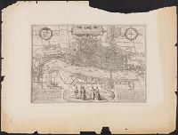
- Beinecke Rare Book and Manuscript Library > Londinvm feracissimi Angliae Regni metropolis.
- Creator:
- Dudley, Robert, Sir, 1574-1649
Dudley, Robert, Sir, 1574-1649. Dell'arcano del mare. 1646-1647
Lucini, Antonio Francesco, b. 1605
- Published / Created:
- 1646-1647]
- Call Number:
- 28 1646
- Container / Volume:
- BRBL_00023E
- Image Count:
- 1
- Resource Type:
- Maps, Atlases & Globes
- Description:
- From the author's Dell'arcano del mare
- Found in:
- Beinecke Rare Book and Manuscript Library > Carta secon[d]a generale del'Asia / A.F. Lucini fece.
- Creator:
- Scull, Nicholas, 1686?-1761?
- Published / Created:
- 1759
- Call Number:
- 774 1759
- Container / Volume:
- BRBL_00497
- Image Count:
- 3
- Resource Type:
- Maps, Atlases & Globes
- Publisher:
- sold by the author Nicholas Scull,
- Found in:
- Beinecke Rare Book and Manuscript Library > To the honourable Thomas Penn and Richard Penn...this map of the improved part of the province of Pennsylvania is humbly dedicated / by Nicholas Scull ; engraved by Ja. Turner.
- Creator:
- Johnston, Alexander Keith, 1804-1871, author
- Call Number:
- 60 1861
- Container / Volume:
- BRBL_00326
- Image Count:
- 1
- Resource Type:
- Maps, Atlases & Globes
- Found in:
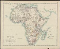
- Beinecke Rare Book and Manuscript Library > Africa / by Keith Johnston, F.R.S.E.
- Creator:
- Johnston, Alexander Keith, 1804-1871, author
- Call Number:
- 60 1860A
- Container / Volume:
- BRBL_00326
- Image Count:
- 1
- Resource Type:
- Maps, Atlases & Globes
- Found in:
- Beinecke Rare Book and Manuscript Library > Africa.
- Creator:
- Güldenstädt, Johann Anton, 1745-1781, author
- Call Number:
- 494 1776
- Container / Volume:
- BRBL_00270
- Image Count:
- 1
- Resource Type:
- Maps, Atlases & Globes
- Found in:
- Beinecke Rare Book and Manuscript Library > Carte de la Mer Caspienne : dressée en 7bre 1776 d'après les dernieres observations / par D. Guldenstaedt ; gravé par P.F. Tardieu.
- Creator:
- Frémont, John Charles, 1813-1890, author.
- Published / Created:
- 1845.
- Call Number:
- 80 1844A
- Image Count:
- 1
- Resource Type:
- Maps, Atlases & Globes
- Found in:
- Beinecke Rare Book and Manuscript Library > Report of the exploring expedition to the Rocky Mountains in the year 1842, and to Oregon and north California in the years 1843-'44 / By Brevet Captain J. C. Frémont, of the topographical engineers under the orders of Col. J. J. Abert, Chief of the Topographical Bureau ; printed by order of the Senate of the United States.
- Published / Created:
- 1886
- Call Number:
- 582 1886
- Container / Volume:
- BRBL_00314
- Image Count:
- 1
- Resource Type:
- Maps, Atlases & Globes
- Description:
- Shows "Author's Route" and propsed
- Found in:
- Beinecke Rare Book and Manuscript Library > Parts of Burma, Siam and the Shan States : illustrating the explorations of Holt S. Hallett, C.E.
- Creator:
- Burwell, Elliot Noël
- Published / Created:
- c1907.
- Call Number:
- 762 W73 1907
- Container / Volume:
- BRBL_00451
- Image Count:
- 1
- Resource Type:
- Maps, Atlases & Globes
- Found in:
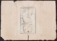
- Beinecke Rare Book and Manuscript Library > A map of Lake Winnipesaukee, New Hampshire / author, Elliot Noël Burwell.
- Creator:
- Arrowsmith, John, 1790-1873
- Published / Created:
- 1844 February 15
- Call Number:
- 70 1844
- Container / Volume:
- BRBL_00359
- Image Count:
- 1
- Resource Type:
- Maps, Atlases & Globes
- Description:
- From the author's London atlas of
- Found in:
- Beinecke Rare Book and Manuscript Library > America / by J. Arrowsmith.
- Creator:
- Porcacchi, Thomaso, ca. 1530-1585?
- Published / Created:
- 1576]
- Call Number:
- 855 1576A
- Container / Volume:
- BRBL_00695
- Image Count:
- 2
- Resource Type:
- Maps, Atlases & Globes
- Description:
- From author's L'isole piu famose del
- Found in:
- Beinecke Rare Book and Manuscript Library > Cvba.
- Creator:
- Des Barres, Joseph F. W. (Joseph Frederick Wallet), 1722-1824
- Published / Created:
- 177-?]
- Call Number:
- 733cea G76 1776
- Container / Volume:
- BRBL_00379
- Image Count:
- 2
- Resource Type:
- Maps, Atlases & Globes
- Description:
- From the author's Atlantic Neptune.
- Found in:
- Beinecke Rare Book and Manuscript Library > [Chart of Passamaquoddy Bay and Grand Manan island, New Brunswick].
- Creator:
- Ogilby, John, 1600-1676
- Published / Created:
- 1670]
- Call Number:
- 64 1670
- Container / Volume:
- BRBL_00338
- Image Count:
- 1
- Resource Type:
- Maps, Atlases & Globes
- Publisher:
- Printed by T. Johnson for the author,
- Found in:
- Beinecke Rare Book and Manuscript Library > Aethiopia inferior vel exterior : partes magis septentrionales, quae hic desiderantur, vide in tabula Aethiopia superioris.
- Creator:
- Ogilby, John, 1600-1676
- Published / Created:
- 1670]
- Call Number:
- 66 1670A
- Container / Volume:
- BRBL_00347
- Image Count:
- 1
- Resource Type:
- Maps, Atlases & Globes
- Publisher:
- Printed by T. Johnson for the author,
- Found in:
- Beinecke Rare Book and Manuscript Library > Aethiopia superior vel interior vulgo Abissinorum sive Presbiteriioannis Imperior.
- Creator:
- Ogilby, John, 1600-1676
- Published / Created:
- 1670]
- Call Number:
- 66 1670
- Container / Volume:
- BRBL_00347
- Image Count:
- 1
- Resource Type:
- Maps, Atlases & Globes
- Publisher:
- Printed by T. Johnson for the author,
- Found in:
- Beinecke Rare Book and Manuscript Library > Barbaria Biledulgerid o: Libye et pars Nigritarum terra.
- Creator:
- Ogilby, John, 1600-1676
- Published / Created:
- 1670]
- Call Number:
- 653 L63 1670
- Container / Volume:
- BRBL_00343
- Image Count:
- 1
- Resource Type:
- Maps, Atlases & Globes
- Publisher:
- Printed by T. Johnson for the author,
- Found in:
- Beinecke Rare Book and Manuscript Library > De stadt van Louango = The citÿ of Lovango.
- Creator:
- Ogilby, John, 1600-1676
- Published / Created:
- 1670]
- Call Number:
- 67 1670
- Container / Volume:
- BRBL_00348
- Image Count:
- 1
- Resource Type:
- Maps, Atlases & Globes
- Publisher:
- Printed by T. Johnson for the author,
- Found in:
- Beinecke Rare Book and Manuscript Library > Fezzae et Marocchi regna Africae celeberrima.
- Creator:
- Ogilby, John, 1600-1676
- Published / Created:
- 1670]
- Call Number:
- 655 1670
- Container / Volume:
- BRBL_00345
- Image Count:
- 1
- Resource Type:
- Maps, Atlases & Globes
- Publisher:
- Printed by T. Johnson for the author,
- Found in:
- Beinecke Rare Book and Manuscript Library > Guinea.
- Creator:
- Ogilby, John, 1600-1676
Ogilby, John, 1600-1676. Africa, being an accurate description of the regions of Egypt, Barbary
- Published / Created:
- 1670]
- Call Number:
- 299 1670
- Container / Volume:
- BRBL_00028
- Image Count:
- 1
- Resource Type:
- Maps, Atlases & Globes
- Publisher:
- Printed by T. Johnson for the author,
- Found in:
- Beinecke Rare Book and Manuscript Library > Insula S. Laurentii, vulgo Madagascar.
- Creator:
- Ogilby, John, 1600-1676
Ogilby, John, 1600-1676. Africa, being an accurate description of the regions of Egypt, Barbary
- Published / Created:
- 1670]
- Call Number:
- 213 1670
- Image Count:
- 1
- Resource Type:
- Maps, Atlases & Globes
- Publisher:
- Printed by T. Johnson for the author,
- Found in:
- Beinecke Rare Book and Manuscript Library > Insulae Promontorii Viridis : Hispanis, Islas de Cabo Verde; Belgis, de Soute Eyelanden.
- Creator:
- Ogilby, John, 1600-1676
- Published / Created:
- 1670]
- Call Number:
- 655 1670A
- Container / Volume:
- BRBL_00345
- Image Count:
- 1
- Resource Type:
- Maps, Atlases & Globes
- Publisher:
- Printed by T. Johnson for the author,
- Found in:
- Beinecke Rare Book and Manuscript Library > Nigritarum regio.
- Creator:
- Ogilby, John, 1600-1676
- Published / Created:
- 1670]
- Call Number:
- 61 1670
- Container / Volume:
- BRBL_00330
- Image Count:
- 1
- Resource Type:
- Maps, Atlases & Globes
- Publisher:
- Printed by T. Johnson for the author,
- Found in:
- Beinecke Rare Book and Manuscript Library > Nova Aegypti tabula.
- Creator:
- Ogilby, John, 1600-1676
- Published / Created:
- 1670]
- Call Number:
- 65 1670
- Container / Volume:
- BRBL_00341
- Image Count:
- 1
- Resource Type:
- Maps, Atlases & Globes
- Publisher:
- Printed by T. Johnson for the author,
- Found in:
- Beinecke Rare Book and Manuscript Library > Regna Congo et Angola
- Creator:
- Nieuhof, Johannes, 1618-1672
Ogilby, John, 1600-1676
Ogilby, John, 1600-1676. Africa, being an accurate description of the regions of Egypt, Barbary
- Published / Created:
- 1670]
- Call Number:
- 215 1670
- Container / Volume:
- BRBL_00015
- Image Count:
- 1
- Resource Type:
- Maps, Atlases & Globes
- Publisher:
- Printed by T. Johnson for the author,
- Found in:
- Beinecke Rare Book and Manuscript Library > St. Helena / door I.N.
- Creator:
- Des Barres, Joseph F. W. (Joseph Frederick Wallet), 1722-1824
- Published / Created:
- Sept. 1 1781.
- Call Number:
- 733cea R49 1781
- Container / Volume:
- BRBL_00379
- Image Count:
- 1
- Resource Type:
- Maps, Atlases & Globes
- Description:
- From the author's Atlantic Neptune.
- Found in:
- Beinecke Rare Book and Manuscript Library > The harbours of Rishibucto & Buctush on the west shore of the Gulph of St. Lawrence.
- Creator:
- Cary, John, ca. 1754-1835
- Published / Created:
- 1801
- Call Number:
- 491 1801
- Container / Volume:
- BRBL_00269
- Image Count:
- 1
- Resource Type:
- Maps, Atlases & Globes
- Description:
- Appears in the author's Cary's new
- Found in:
- Beinecke Rare Book and Manuscript Library > A new map of Turkey in Europe, divided into its provinces, from the best authorities / by John Cary, engraver.
- Creator:
- Portugal. Comissão de Cartografia das Colónias, author
- Call Number:
- 6514 1885
- Container / Volume:
- BRBL_00342
- Image Count:
- 1
- Resource Type:
- Maps, Atlases & Globes
- Found in:
- Beinecke Rare Book and Manuscript Library > Carta da Ilha de S. Thomé / Comissão de Cartographia ; coordenada por Ernesto de Vasconcellos ; desenhada por A. A. d' Oliveira.
- Creator:
- Portugal. Comissão de Cartografia das Colónias, author
- Published / Created:
- 1887
- Call Number:
- 636 1887
- Container / Volume:
- BRBL_00337
- Image Count:
- 1
- Resource Type:
- Maps, Atlases & Globes
- Found in:
- Beinecke Rare Book and Manuscript Library > Carta do Districto de Manica e dos territorios circumvizinhos / Comissão de Cartographia ; Carvalho gr.
- Creator:
- United States. Army. Corps of Engineers, author
- Published / Created:
- [1834]
- Call Number:
- 761 1834
- Container / Volume:
- BRBL_00447
- Image Count:
- 1
- Resource Type:
- Maps, Atlases & Globes
- Found in:
- Beinecke Rare Book and Manuscript Library > The Kennebec River and adjacent country : shewing the routes examined for a road from Augusta to the Canada line in the direction of Quebec / reconnaissance made in 1834 by Hartman Bache, T.E. & B.T. Major, assisted by G.W. Ward, 2nd Lt. 2nd Arty. and J.F
- Creator:
- Bellin, Jacques Nicolas, 1703-1772
- Published / Created:
- 1764].
- Call Number:
- 755 1764
- Container / Volume:
- BRBL_00429
- Image Count:
- 1
- Resource Type:
- Maps, Atlases & Globes
- Description:
- Appears in the author's Le petit atlas
- Found in:
- Beinecke Rare Book and Manuscript Library > Carte de la Nouvelle Angleterre : New York, Pensilvanie et Nouveau Jersay suivant les cartes angloises.
- Creator:
- Jansson, Jan, 1588-1664
- Published / Created:
- 1652?]
- Call Number:
- 406 1652A
- Container / Volume:
- BRBL_00236
- Image Count:
- 1
- Resource Type:
- Maps, Atlases & Globes
- Description:
- From the author's Accuratissima orbis
- Found in:
- Beinecke Rare Book and Manuscript Library > Latium.
- Creator:
- Langren, Arnold Florent van, 1580-1644, cartographer
- Published / Created:
- [1638]
- Call Number:
- 90 1638
- Container / Volume:
- BRBL_00661
- Image Count:
- 1
- Resource Type:
- Maps, Atlases & Globes
- Found in:
- Beinecke Rare Book and Manuscript Library > Delineatio omnium orarum totius Australis partis Americae ... / Arnoldus Florentius à Langren, author & sculptor.
- Creator:
- Des Barres, Joseph F. W. (Joseph Frederick Wallet), 1722-1824
- Published / Created:
- Septr. 1 1781.
- Call Number:
- 733cea M67 1781
- Container / Volume:
- BRBL_00379
- Image Count:
- 1
- Resource Type:
- Maps, Atlases & Globes
- Description:
- From the author's Atlantic Neptune.
- Found in:
- Beinecke Rare Book and Manuscript Library > [A chart of the bay and river of Miramichy / surveyed by Samuel Holland].
- Creator:
- Des Barres, Joseph F. W. (Joseph Frederick Wallet), 1722-1824
- Published / Created:
- March 1781.
- Call Number:
- 732cea L97 1781
- Container / Volume:
- BRBL_00378
- Image Count:
- 1
- Resource Type:
- Maps, Atlases & Globes
- Description:
- From the author's Atlantic Neptune.
- Found in:
- Beinecke Rare Book and Manuscript Library > King's Bay, Lunenburg.
- Creator:
- Jansson, Jan, 1588-1664
- Published / Created:
- 1652?]
- Call Number:
- 400 L39 1652
- Container / Volume:
- BRBL_00233
- Image Count:
- 1
- Resource Type:
- Maps, Atlases & Globes
- Description:
- Appears in the author's Accuratissima
- Found in:
- Beinecke Rare Book and Manuscript Library > Latium.
- Creator:
- Thevet, André, 1502-1590
- Published / Created:
- 1575]
- Call Number:
- 60 1575
- Container / Volume:
- BRBL_00321
- Image Count:
- 1
- Resource Type:
- Maps, Atlases & Globes
- Description:
- Appears in the author's Cosmographie
- Found in:
- Beinecke Rare Book and Manuscript Library > Table d'Afrique / A. Thevet.
- Creator:
- Thevet, André, 1502-1590
- Published / Created:
- 1575]
- Call Number:
- 50 1575
- Container / Volume:
- BRBL_00733
- Image Count:
- 1
- Resource Type:
- Maps, Atlases & Globes
- Description:
- Appears in the author's Cosmographie
- Found in:
- Beinecke Rare Book and Manuscript Library > Asie / A. Thevet, cosmographe du Roy.
- Creator:
- Tardieu, P. F. (Pierre François), 1757-1822, author
- Call Number:
- 451 1770
- Container / Volume:
- BRBL_00258
- Image Count:
- 1
- Resource Type:
- Maps, Atlases & Globes
- Found in:
- Beinecke Rare Book and Manuscript Library > Bender : assiege & pris par les Russes en 1770 / gravé par P.F. Tardieu.
- Creator:
- Tardieu, P. F. (Pierre François), 1757-1822, author
- Call Number:
- 45 1771
- Container / Volume:
- BRBL_00258
- Image Count:
- 1
- Resource Type:
- Maps, Atlases & Globes
- Found in:
- Beinecke Rare Book and Manuscript Library > Plan de l'Attaque du Retranchement, du Camp, et de la Flotte des Turcs par le Gal. Weisman, près de Tultschi, le 30 Juin 1771 / gravé par P.F. Tardieu.
- Creator:
- Tardieu, P. F. (Pierre François), 1757-1822, author
- Call Number:
- 451 1785
- Container / Volume:
- BRBL_00258
- Image Count:
- 1
- Resource Type:
- Maps, Atlases & Globes
- Found in:
- Beinecke Rare Book and Manuscript Library > Plan de la bataille & de la victoire remporteé par les Russes sur les Turcs commandés par le Grand Visir près de la riviere Kagul en Bessarabie, le 21 Juillet, 1770 / gravé par P.F. Tardieu.