Search
You Searched For
Search Results
- Published / Created:
- 1776
- Call Number:
- 771 C358 1776C
- Container / Volume:
- BRBL_00482
- Image Count:
- 1
- Resource Type:
- Maps, Atlases & Globes
- Found in:
- Beinecke Rare Book and Manuscript Library > A Survey of Lake Champlain including Lake George, Crown Point, and St. John ... by William Brassier, Draughtsman. 1762.
- Published / Created:
- 1776
- Call Number:
- 771 C358 1776
- Container / Volume:
- BRBL_00482
- Image Count:
- 1
- Resource Type:
- Maps, Atlases & Globes
- Found in:
- Beinecke Rare Book and Manuscript Library > A Survey of Lake Champlain including Lake George, Crown Point, and St. John : surveyed by order of his Excellency major General Sr. Jeffery Amherst ... / by William Brassier, Draughtsman, 1762.
- Creator:
- Speed, John, 1552?-1629
- Published / Created:
- [1676]
- Call Number:
- 755 1672A
- Container / Volume:
- BRBL_00423
- Image Count:
- 2
- Resource Type:
- Maps, Atlases & Globes
- Found in:
- Beinecke Rare Book and Manuscript Library > A map of New England and New York / F. Lamb sculp.
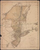
- Published / Created:
- 1776
- Call Number:
- 755 1776D
- Container / Volume:
- BRBL_00430
- Image Count:
- 1
- Resource Type:
- Maps, Atlases & Globes
- Found in:
- Beinecke Rare Book and Manuscript Library > A map of the Province of New York ... by Claude Joseph Sauthier ... New Jersey ... Engraved by Wm. Faden.
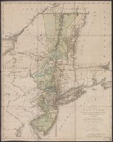
- Creator:
- Kitchin, Thomas, 1718-1784
- Published / Created:
- 1756
- Call Number:
- 755 1765A
- Container / Volume:
- BRBL_00690
- Image Count:
- 1
- Resource Type:
- Maps, Atlases & Globes
- Found in:
- Beinecke Rare Book and Manuscript Library > A map of the eastern part of the Province of New York : with part of New Jersey &c. / drawn from the best authorities by T. Kitchin geogr.
- Creator:
- Faden, William, 1749-1836
- Published / Created:
- 1777
- Call Number:
- 73 1777
- Container / Volume:
- BRBL_00373
- Image Count:
- 1
- Resource Type:
- Maps, Atlases & Globes
- Found in:
- Beinecke Rare Book and Manuscript Library > A map of the inhabited part of Canada from the French surveys, with the frontiers of New York and New England; from the large survey by Claude Joseph Sauthier. Engraved by Wm. Faden, 1777.
- Creator:
- Thornton, John, fl. 1652-1701
- Published / Created:
- [1673?]
- Call Number:
- 755 1682B
- Container / Volume:
- BRBL_00424
- Image Count:
- 1
- Resource Type:
- Maps, Atlases & Globes
- Found in:
- Beinecke Rare Book and Manuscript Library > A mapp of Virginia, Mary-land, New-Jarsey, New-York, & New England.
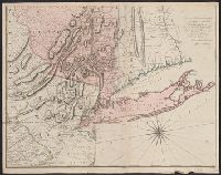
- Published / Created:
- 1775
- Call Number:
- 771 1775A
- Container / Volume:
- BRBL_00477
- Image Count:
- 2
- Resource Type:
- Maps, Atlases & Globes
- Found in:
- Beinecke Rare Book and Manuscript Library > Map of the Province of New York with part of Pennsilvania and New England ...
- Published / Created:
- 1776
- Call Number:
- 771hc 1776
- Container / Volume:
- BRBL_00714
- Image Count:
- 1
- Resource Type:
- Maps, Atlases & Globes
- Found in:
- Beinecke Rare Book and Manuscript Library > Plan of the Operations of the British army in North America, Commanded by General Howe from the 15th to the 16th Nov. 1776.