Date inferred from Stevens and Tree's Comparative cartography, which lists two issues, date, Date on map: 4th September 1804., Includes ornate title cartouche with American plants and animals, engraved by W. & G. Cooke., and Relief shown by hachures and shading.
Publisher:
A. Arrowsmith, No. 10 Soho Square,
Subject (Geographic):
America--Maps
Subject (Name):
W. & G. Cooke, West, W., engraver, and Wilson, H., engraver
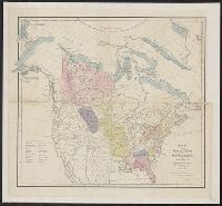
Bar scale given in "English miles.", Relief shown by hachures., and Shows cities, military posts, areas of Indian habitation, "Russian Territory," "British Territory," and the United States with California, the Southwest, and Texas as part of Mexico; U.S. boundary coloration does not include "Oregon or Western Territory" and dotted/printed boundary follows the Columbia River.
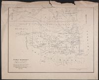
"Prepared from the map of Daniel C. Major ... and from Lieut. Col. J.E. Johnston's Map of the southern boundary of Kansas in 1857. [And from] the Map of the Creek country by Lieut. I.C. Woodruff, Topl. Engrs., in 1850-51." and Publication place and date inferred from description in Streeter's The celebrated collection of Americana ..., 575.
Publisher:
Engineer Bureau War Dept.,
Subject (Geographic):
Indian Territory--Maps
Subject (Name):
Johnston, Joseph E. (Joseph Eggleston), 1807-1891, Major, Daniel C, United States. War Dept. Engineer Bureau, and Woodruff, I. C
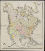
"Pendleton's Lithography.", From: American Antiquarian Society. Transactions and collections. Vol. 2, 1836, fol. p. 264., Hand colored to show the location of Indian tribes and 11 linguistic families., and Relief shown pictorially.
National Geographic Society (U.S.). Cartographic Division
Published / Created:
1982
Call Number:
7821 1982
Container / Volume:
BRBL_00506
Image Count:
2
Resource Type:
Maps, Atlases & Globes
Alternative Title:
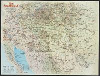
Making of America, the Southwest
Description:
"Supplement to the National Geographic, November 1982, page 630A, Vol. 162, No. 5.", Relief shown by shading and spot heights., and Text, ill., and maps of early Indian occupancy, Spanish Conquest 1540-1820, Anglo-American entry and occupancy 1820-1900, and the
Publisher:
The Society,
Subject (Geographic):
America--Discovery and exploration--Spanish--Maps, Southwest, New--History--Maps, and Southwest, New--Maps
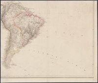
In lower margin: London: Published 1 Jan. 1795 by A. Arrowsmith, No. 10 Soho Square ... additions to 1802., Includes notes., and Relief shown by hachures.
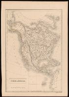
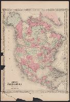
Appears in Johnson's New illustrated family atlas .... 1866., Numbers in right margin: 15, 16., On verso: Geographical index, or ready reference, [p.] 27, 28., Prime meridians: Washington and Greenwich., and Relief shown by hachures.
Publisher:
A.J. Johnson?,
Subject (Geographic):
NorthAmerica--Maps
Subject (Name):
Johnson, A. J. (Alvin Jewett), 1827-1884. Johnson's New illustrated family atlas of the world