Search
You Searched For
Search Results
- Creator:
- Hollar, Wenceslaus, 1607-1677.
- Call Number:
- 1980 458
- Image Count:
- 18
- Resource Type:
- Maps, Atlases & Globes
- Found in:
- Beinecke Rare Book and Manuscript Library > The kingdome of England & principality of Wales : exactly described whith euery sheere & the small townes in euery one of them, in six mappes, portable for euery mans pocket ... : vsefull for all gentlemen and travellors and all sorts of persons, that would be informed of the distance of places neuer so commodiously drawne before this, 1676, described by one that trauailed throughout the whole kingdome, for its purpose / W. Hollar, fecit.
- Published / Created:
- [1692?]
- Call Number:
- 32 1692
- Container / Volume:
- BRBL_00042
- Image Count:
- 12
- Resource Type:
- Maps, Atlases & Globes
- Found in:
- Beinecke Rare Book and Manuscript Library > Angliae totius tabula cum distantius in itinerantium usum accomadata ... Philip Lea. Iohannes Adams ... descripsit. Thomas Burnford ... sculpsit.
- Creator:
- Morgan, William, -1690
- Published / Created:
- 1682] and 1904.
- Call Number:
- 32 L84 1682/1904
- Container / Volume:
- BRBL_00737
- Image Count:
- 12
- Resource Type:
- Maps, Atlases & Globes
- Found in:
- Beinecke Rare Book and Manuscript Library > London &c. actually surveyed, by Wm. Morgan, his ma[jes]ties cosmogr., 1681/2.
- Published / Created:
- 1652?]
- Call Number:
- 11 1652
- Container / Volume:
- BRBL_00732
- Image Count:
- 4
- Resource Type:
- Maps, Atlases & Globes
- Found in:
- Beinecke Rare Book and Manuscript Library > Tabvla itineraria ex illustri Peutingerorum, bibliotheca quae Augustae Vindelicorum / beneficio Marci Velseri, septem-viri Augustani in lucem edita.
- Creator:
- Visscher, Claes Jansz., 1586 or 1587-1652
- Published / Created:
- 1616. and 1883-1885.
- Call Number:
- 32 L84 1616/1883
- Container / Volume:
- BRBL_00736
- Image Count:
- 4
- Resource Type:
- Maps, Atlases & Globes
- Found in:
- Beinecke Rare Book and Manuscript Library > London. Visscher delineavit.
- Published / Created:
- ca. 163--1734]
- Call Number:
- 1973 Folio 18
- Image Count:
- 10
- Resource Type:
- Maps, Atlases & Globes
- Found in:
- Beinecke Rare Book and Manuscript Library > [Composite atlas of the world].
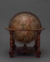
- Creator:
- Coronelli, Vincenzo, 1650-1718.
- Published / Created:
- 1699]
- Call Number:
- Globe 21
- Image Count:
- 10
- Resource Type:
- Maps, Atlases & Globes
- Found in:
- Beinecke Rare Book and Manuscript Library > Amico Lettore / Oltre al molti Globi delineati dal P. Cosmografo Coronelli per Sourani diuersi di uarie e uaste misure ne ha ultimamente composti e stampi di cinque grandezze a publica beneficio, fra quali i piu commodi, ed exalti sono i presenti. I Numer
- Published / Created:
- [1633?]
- Call Number:
- 32 1633
- Container / Volume:
- BRBL_00042
- Image Count:
- 7
- Resource Type:
- Maps, Atlases & Globes
- Found in:
- Beinecke Rare Book and Manuscript Library > [England & Wales]
- Creator:
- Hollar, Wenceslaus, 1607-1677
- Call Number:
- 1973 265
- Image Count:
- 27
- Resource Type:
- Maps, Atlases & Globes
- Found in:
- Beinecke Rare Book and Manuscript Library > The kingdome of England & principality of Wales : exactly described whith euery sheere & the small townes in euery one of them, in six mappes, portable for euery mans pocket ... : vsefull for all comanders for quarteringe of souldiers, & all sorts of persons, that would be informed, where the armies be, neuer so commodiously drawne before this, 1644, described by one that trauailed throughout the whole kingdome, for its purpose / W. Hollar, fecit.
- Creator:
- Duval, P. (Pierre), 1619-1682.
- Published / Created:
- 1671
- Call Number:
- 1973 Folio 31
- Image Count:
- 78
- Resource Type:
- Maps, Atlases & Globes
- Found in:
- Beinecke Rare Book and Manuscript Library > Cartes de geographie, les plus nouvelles et les plus fideles, auecque leurs diuisions régulieres, par P. du Val ...
- Published / Created:
- 1656
- Call Number:
- 97 1656
- Container / Volume:
- BRBL_00677
- Image Count:
- 1
- Resource Type:
- Maps, Atlases & Globes
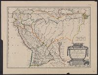
- Found in:
- Beinecke Rare Book and Manuscript Library > Le Perou et le cours dela Riviere Amazone... par N. Sanson d' Abbeville.
- Creator:
- Blaeu, Willem Janszoon, 1571-1638
- Published / Created:
- [ca. 1630]
- Call Number:
- 97 1631
- Container / Volume:
- BRBL_00677
- Image Count:
- 1
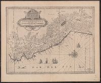
- Resource Type:
- Maps, Atlases & Globes
- Found in:
- Beinecke Rare Book and Manuscript Library > Peru.
- Creator:
- Blaeu, Willem Janszoon, 1571-1638
- Published / Created:
- [ca. 1630]
- Call Number:
- 96 1667
- Container / Volume:
- BRBL_00676
- Image Count:
- 1
- Resource Type:
- Maps, Atlases & Globes
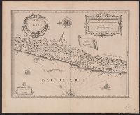
- Found in:
- Beinecke Rare Book and Manuscript Library > Chili [cartographic material].
- Published / Created:
- 1656
- Call Number:
- 935 1656
- Container / Volume:
- BRBL_00674
- Image Count:
- 1
- Resource Type:
- Maps, Atlases & Globes
- Found in:
- Beinecke Rare Book and Manuscript Library > Le Paraguayr, Le Chili, la terre, et les isles Magellaniques, tirées de diverses relations, par N. Sanson d'Abbeville... Somer Pruth sculp.
- Published / Created:
- 1671]
- Call Number:
- 97 1671
- Container / Volume:
- BRBL_00677
- Image Count:
- 1
- Resource Type:
- Maps, Atlases & Globes
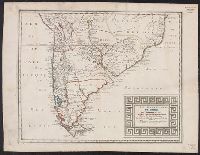
- Found in:
- Beinecke Rare Book and Manuscript Library > Perv [by William Blaeu, adapted by Jacob van Meurs].
- Creator:
- Blaeu, Willem Janszoon, 1571-1638
- Published / Created:
- [ca. 1630]
- Call Number:
- 97 1631
- Container / Volume:
- BRBL_00677
- Image Count:
- 1
- Resource Type:
- Maps, Atlases & Globes
- Found in:
- Beinecke Rare Book and Manuscript Library > Peru.
- Published / Created:
- 1670]
- Call Number:
- 911 1670
- Container / Volume:
- BRBL_00668
- Image Count:
- 1
- Resource Type:
- Maps, Atlases & Globes
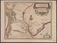
- Found in:
- Beinecke Rare Book and Manuscript Library > Brasilia.
- Creator:
- Vooght, Claes Janszoon, -1696
- Published / Created:
- [ca. 1685]
- Call Number:
- 911cea C111 1685
- Container / Volume:
- BRBL_00670
- Image Count:
- 1
- Resource Type:
- Maps, Atlases & Globes
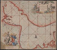
- Found in:
- Beinecke Rare Book and Manuscript Library > Paskaart van de zee-kusten van Brazilia, tusschen C.S. Thome en I.S. Catharina / door Vooght geometra.
- Published / Created:
- [1635]
- Call Number:
- 966 1635
- Container / Volume:
- BRBL_00676
- Image Count:
- 1
- Resource Type:
- Maps, Atlases & Globes
- Found in:
- Beinecke Rare Book and Manuscript Library > Tabula Magellanico, qua Tierrae del fuego, cum celerrimis fretis a F. Magellano et L. Le Maire detectis novissima et accuratissimo descriptio exhibetur.
- Published / Created:
- 1612
- Call Number:
- 38 H453 1612
- Container / Volume:
- BRBL_00703
- Image Count:
- 1
- Resource Type:
- Maps, Atlases & Globes
- Found in:
- Beinecke Rare Book and Manuscript Library > La Ville de Hesdin.
- Published / Created:
- 1643
- Call Number:
- 11 1643
- Container / Volume:
- BRBL_00700
- Image Count:
- 1
- Resource Type:
- Maps, Atlases & Globes
- Found in:
- Beinecke Rare Book and Manuscript Library > [Portolan chart of the World].
- Published / Created:
- 1619?]
- Call Number:
- 21cea 1619
- Container / Volume:
- BRBL_00700
- Image Count:
- 1
- Resource Type:
- Maps, Atlases & Globes
- Found in:
- Beinecke Rare Book and Manuscript Library > [Anonymous ms. Portugese portolano of the Atlantic Ocean.]
- Published / Created:
- [1683?]
- Call Number:
- 23 1683
- Container / Volume:
- BRBL_00700
- Image Count:
- 1
- Resource Type:
- Maps, Atlases & Globes
- Found in:
- Beinecke Rare Book and Manuscript Library > Wassende graadt kaert vande Groote Zud Zee.
- Published / Created:
- 1684
- Call Number:
- 18 1684
- Container / Volume:
- BRBL_00700
- Image Count:
- 1
- Resource Type:
- Maps, Atlases & Globes
- Found in:
- Beinecke Rare Book and Manuscript Library > The Northern part of ye World projected upon the Plaine of the Equator. By Anthony Payne ... A. AE 15 1/2. 1684.
- Published / Created:
- c1640]
- Call Number:
- 3365 1640
- Container / Volume:
- BRBL_00701
- Image Count:
- 1
- Resource Type:
- Maps, Atlases & Globes
- Found in:
- Beinecke Rare Book and Manuscript Library > T'fort aende Warande [cartographic material].
- Creator:
- Hondius, Jodocus, 1594 or 1595-1629
- Published / Created:
- [1629]
- Call Number:
- 919 1630A
- Container / Volume:
- BRBL_00699
- Image Count:
- 1
- Resource Type:
- Maps, Atlases & Globes
- Found in:
- Beinecke Rare Book and Manuscript Library > Paraguay, ó, prov. de Rio de la Plata cum regionibus adiacentibus Tucuman et Sta. Cruz de la Sierra [cartographic material].
- Published / Created:
- [1690?]
- Call Number:
- 521 J565 1690
- Container / Volume:
- BRBL_00707
- Image Count:
- 1
- Resource Type:
- Maps, Atlases & Globes
- Found in:
- Beinecke Rare Book and Manuscript Library > [Manuscript map of the Red Sea around the town of Jiddah (or Jedda.)].
- Published / Created:
- 1678
- Call Number:
- 35 1678
- Container / Volume:
- BRBL_00722
- Image Count:
- 1
- Resource Type:
- Maps, Atlases & Globes
- Found in:
- Beinecke Rare Book and Manuscript Library > Russia bianca o Moscovia ... / Giorgio Widman sculpsit.
- Creator:
- Sanson, Nicolas, 1600-1667
- Published / Created:
- 1669
- Call Number:
- 50 1669
- Container / Volume:
- BRBL_00723
- Image Count:
- 1
- Resource Type:
- Maps, Atlases & Globes
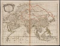
- Found in:
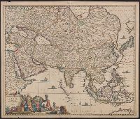
- Beinecke Rare Book and Manuscript Library > L' Asie / par N. Sanson, Geographe Ordre. du Roy.
- Published / Created:
- [1650?]
- Call Number:
- 352 1650A
- Container / Volume:
- BRBL_00722
- Image Count:
- 1
- Resource Type:
- Maps, Atlases & Globes
- Found in:
- Beinecke Rare Book and Manuscript Library > Novissima et accuratissima totius Russiæ vulgo Muscvoiæ tabula / a Iusto Danckerts ...
- Published / Created:
- [1681]
- Call Number:
- 352 W58 1681
- Container / Volume:
- BRBL_00723
- Image Count:
- 1
- Resource Type:
- Maps, Atlases & Globes
- Found in:
- Beinecke Rare Book and Manuscript Library > Paskaart van de Witt Zee ...
- Published / Created:
- [1650]
- Call Number:
- 352 B237 1650
- Container / Volume:
- BRBL_00723
- Image Count:
- 1
- Resource Type:
- Maps, Atlases & Globes
- Found in:
- Beinecke Rare Book and Manuscript Library > Paskaart vande noord kust van Moscovien ... / door Teunis Ys opgegeven ...
- Published / Created:
- 1660?]
- Call Number:
- 5 1660
- Container / Volume:
- BRBL_00723
- Image Count:
- 1
- Resource Type:
- Maps, Atlases & Globes
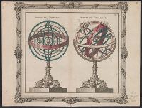
- Found in:
- Beinecke Rare Book and Manuscript Library > [Illustration of celestial spheres of Copernicus and Ptolemy].
- Creator:
- Sanson, Nicolas, 1600-1667
- Published / Created:
- 1679
- Call Number:
- 352 1679
- Container / Volume:
- BRBL_00722
- Image Count:
- 1
- Resource Type:
- Maps, Atlases & Globes
- Found in:
- Beinecke Rare Book and Manuscript Library > Estats du Czar ou Grand Duc de la Russie Blanche ou Moscovie [cartographic material] / par N. Sanson le fils ... ; A. Peyrounin sculp.
- Creator:
- Massa, Isaac, 1587-1635
- Published / Created:
- ca. 1680]
- Call Number:
- 352 1630
- Container / Volume:
- BRBL_00722
- Image Count:
- 1
- Resource Type:
- Maps, Atlases & Globes
- Found in:
- Beinecke Rare Book and Manuscript Library > Moscoviae pars australis / auctore Isaaco Maβa.
- Published / Created:
- [1681]
- Call Number:
- 50cea 1681
- Container / Volume:
- BRBL_00723
- Image Count:
- 1
- Resource Type:
- Maps, Atlases & Globes
- Found in:
- Beinecke Rare Book and Manuscript Library > Pascaarte vande noord oost cust van Asia ...
- Published / Created:
- [1670?]
- Call Number:
- 50 1670
- Container / Volume:
- BRBL_00723
- Image Count:
- 1
- Resource Type:
- Maps, Atlases & Globes
- Found in:
- Beinecke Rare Book and Manuscript Library > Accuratissima totius Asiæ tabula, recens emendata / per Fredericum de Wit ...
- Published / Created:
- [1651?]
- Call Number:
- 352 1651
- Container / Volume:
- BRBL_00722
- Image Count:
- 1
- Resource Type:
- Maps, Atlases & Globes
- Found in:
- Beinecke Rare Book and Manuscript Library > Tabula Russiæ / ex mandata Foedor Borissowitz delineata ... ; dedicata a Nicolae Ioannis Piscatore ...
- Published / Created:
- 1660?]
- Call Number:
- 6 1660
- Container / Volume:
- BRBL_00723
- Image Count:
- 1
- Resource Type:
- Maps, Atlases & Globes
- Found in:
- Beinecke Rare Book and Manuscript Library > [Illustration of terrestrial and celestial globes].
- Published / Created:
- [1681]
- Call Number:
- 303cea 1681
- Container / Volume:
- BRBL_00722
- Image Count:
- 1
- Resource Type:
- Maps, Atlases & Globes
- Found in:
- Beinecke Rare Book and Manuscript Library > Paskaart van't noordelykste deel der Noort Zee beginnende van der Neus tot Nova Zemla ...
- Published / Created:
- [1660?]
- Call Number:
- 70 1660
- Container / Volume:
- BRBL_00724
- Image Count:
- 1
- Resource Type:
- Maps, Atlases & Globes
- Found in:
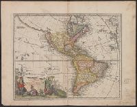
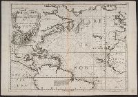
- Beinecke Rare Book and Manuscript Library > Novi orbis, sive totius Americae, cum adiacentibus insulis, nova exhibitio.
- Creator:
- Laet, Joannes de, 1581-1649
- Published / Created:
- 1630]
- Call Number:
- 71 1630
- Container / Volume:
- BRBL_00725
- Image Count:
- 1
- Resource Type:
- Maps, Atlases & Globes
- Found in:
- Beinecke Rare Book and Manuscript Library > Florida, et regiones vicinae [cartographic material].
- Creator:
- Allard, Carel, 1648-ca. 1709.
- Published / Created:
- 1696]
- Call Number:
- 1973 Folio 18
- Image Count:
- 1
- Resource Type:
- Maps, Atlases & Globes
- Found in:
- Beinecke Rare Book and Manuscript Library > Planisphaerium terrestre, sive terrarum orbis, planisphaericè constructi repraesentatio quintuplex [cartographic material] : adjunctis aliquibus astronomicae geographiae tyrociniis / auctore Carolo Allard, Amstelo-Batavo = Vlakke aard-kloot, gemeenlyk genaamd de geheele waereld, vysvoudiglyk in vlakke ronden verbeeld : mitsgaders eenige noodige ontwerpen des sterrekundigen aard-beschryvings / door Carel Allard, tot Amsterdam.
- Creator:
- Keere, Pieter van den, 1571-approximately 1646
- Published / Created:
- [between 1652 and 1684]
- Call Number:
- BrSides Double Folio 2019 56
- Image Count:
- 1
- Resource Type:
- Maps, Atlases & Globes
- Found in:
- Beinecke Rare Book and Manuscript Library > Argonavtica / Petrus Kaerius caelavit aetatis suae 74.
- Creator:
- Jansson, Jan, 1588-1664, cartographer, publisher.
- Published / Created:
- [between 1652 and 1684]
- Call Number:
- BrSides Double Folio 2019 100
- Image Count:
- 1
- Resource Type:
- Maps, Atlases & Globes
- Found in:
- Beinecke Rare Book and Manuscript Library > Tribvs Rvben, et Gad et partes orientales tribuum Beniamin, Ephraim, et dimidiae Manasse intra Iordanem.
- Creator:
- Jansson, Jan, 1588-1664, cartographer, publisher.
- Published / Created:
- [between 1652 and 1684]
- Call Number:
- BrSides Double Folio 2019 100
- Image Count:
- 1
- Resource Type:
- Maps, Atlases & Globes
- Found in:
- Beinecke Rare Book and Manuscript Library > Dimidia Tribus Manasse ultra Iordanem, tribus Neptalim et partes orientales tribuum Zabuion et Isachar.
- Creator:
- Jansson, Jan, 1588-1664, cartographer, publisher.
- Published / Created:
- [between 1652 and 1684]
- Call Number:
- BrSides Double Folio 2019 100
- Image Count:
- 1
- Resource Type:
- Maps, Atlases & Globes
- Found in:
- Beinecke Rare Book and Manuscript Library > Tribus Aser, et partes occidentales tribuum Zabulon et Isachar.
- Creator:
- Jansson, Jan, 1588-1664, cartographer, publisher.
- Published / Created:
- [between 1652 and 1684]
- Call Number:
- BrSides Double Folio 2019 100
- Image Count:
- 1
- Resource Type:
- Maps, Atlases & Globes
- Found in:
- Beinecke Rare Book and Manuscript Library > Pars maxima tribvs Ivda versus orientem.
- Creator:
- Ortelius, Abraham, 1527-1598
- Published / Created:
- [approximately 1680?]
- Call Number:
- BrSides Double Folio 2019 64
- Image Count:
- 1
- Resource Type:
- Maps, Atlases & Globes
- Found in:
- Beinecke Rare Book and Manuscript Library > Creta Iovis magni, medio jacet insula ponto / ex conatibus geographicis Abrahami Ortelij.
- Creator:
- Keere, Pieter van den, 1571-approximately 1646
- Published / Created:
- [between 1652 and 1684]
- Call Number:
- BrSides Double Folio 2019 62
- Image Count:
- 1
- Resource Type:
- Maps, Atlases & Globes
- Found in:
- Beinecke Rare Book and Manuscript Library > Italia Gallica, sive, Gallia Cisalpina / ex conatibus geographicis Abrah. Ortelij.
- Creator:
- Jansson, Jan, 1588-1664
- Published / Created:
- [1680?]
- Call Number:
- BrSides Double Folio 2019 95
- Image Count:
- 1
- Resource Type:
- Maps, Atlases & Globes
- Found in:
- Beinecke Rare Book and Manuscript Library > Imperium Caroli Magni.
- Published / Created:
- [between 1652 and 1684]
- Call Number:
- BrSides Double Folio 2019 99
- Image Count:
- 1
- Resource Type:
- Maps, Atlases & Globes
- Found in:
- Beinecke Rare Book and Manuscript Library > Britannia prout divisa fuit temporibus Anglo-Saxonvm praesertim durante illorum heptarchia.
- Creator:
- Jansson, Jan, 1588-1664, cartographer, publisher.
- Published / Created:
- [between 1652 and 1684]
- Call Number:
- BrSides Double Folio 2019 100
- Image Count:
- 1
- Resource Type:
- Maps, Atlases & Globes
- Found in:
- Beinecke Rare Book and Manuscript Library > Tribvs Simeon et pars meridionalis tribvs Dan, et orientalis tribvs Ivda.
- Creator:
- Keere, Pieter van den, 1571-approximately 1646, cartographer.
- Published / Created:
- [between 1652 and 1684]
- Call Number:
- BrSides Double Folio 2019 103
- Image Count:
- 1
- Resource Type:
- Maps, Atlases & Globes
- Found in:
- Beinecke Rare Book and Manuscript Library > Germaniae veteris nova descriptio / Petrus Kaerius celavit.
- Creator:
- Jansson, Jan, 1588-1664, cartographer, publisher.
- Published / Created:
- [between 1652 and 1684]
- Call Number:
- BrSides Double Folio 2019 101
- Image Count:
- 1
- Resource Type:
- Maps, Atlases & Globes
- Found in:
- Beinecke Rare Book and Manuscript Library > Tabula itineraria patriarcharum Abrahami, Isaaci et Iacobi.
- Creator:
- Goos, Abraham
- Published / Created:
- [between 1652 and 1680]
- Call Number:
- BrSides Double Folio 2019 96
- Image Count:
- 1
- Resource Type:
- Maps, Atlases & Globes
- Found in:
- Beinecke Rare Book and Manuscript Library > Hispaniae veteris descriptio / Abraham Goos sculpsit.
- Creator:
- Lauremberg, Johann, 1590-1658
- Published / Created:
- [1680?]
- Call Number:
- BrSides Double Folio 2019 53
- Image Count:
- 1
- Resource Type:
- Maps, Atlases & Globes
- Found in:
- Beinecke Rare Book and Manuscript Library > Hellas, seu Graecia universa / auctore I. Laurenbergio ; F. de Wit excudit.
- Creator:
- Keere, Pieter van den, 1571-approximately 1646
- Published / Created:
- [1652?]
- Call Number:
- BrSides Double Folio 2019 66
- Image Count:
- 1
- Resource Type:
- Maps, Atlases & Globes
- Found in:
- Beinecke Rare Book and Manuscript Library > Pontos Euxeinos = Pontus Euxinus : æquor Iasonio pulsatum remige primum / ex conatibus Abrahami Ortelii ; Petrus Kaerius caelavit.
- Creator:
- Keere, Pieter van den, 1571-approximately 1646
- Published / Created:
- [between 1652 and 1684]
- Call Number:
- BrSides Double Folio 2019 58
- Image Count:
- 1
- Resource Type:
- Maps, Atlases & Globes
- Found in:
- Beinecke Rare Book and Manuscript Library > Vetvs descriptio Daciarum nec non Moesiarvm : vrbes incognitae positionis huc referendae sunt / Petrus Kaerius caelavit.
- Creator:
- Jansson, Jan, 1588-1664
- Published / Created:
- [between 1652 and 1684]
- Call Number:
- BrSides Double Folio 2019 59
- Image Count:
- 1
- Resource Type:
- Maps, Atlases & Globes
- Found in:
- Beinecke Rare Book and Manuscript Library > Veteris Pannoniae utriusque, nec non Illyrici descriptio geographica.
- Creator:
- Keere, Pieter van den, 1571-approximately 1646
- Published / Created:
- [between 1652 and 1684]
- Call Number:
- BrSides Double Folio 2019 57
- Image Count:
- 1
- Resource Type:
- Maps, Atlases & Globes
- Found in:
- Beinecke Rare Book and Manuscript Library > Thrakē = Thraciae veteris typus / ex conatibus geographicis Abrah. Ortelij. ; Petrus Kaerius caelavit.
- Creator:
- Ewicius, Hermann, 1597-1651, publisher
- Published / Created:
- [approximately 1660]
- Call Number:
- BrSides Double Folio 2019 73
- Image Count:
- 1
- Resource Type:
- Maps, Atlases & Globes
- Found in:
- Beinecke Rare Book and Manuscript Library > Patriae antiquae Inter Iuly et Caroli Magni : caesarum Romanorum tempora descriptio / Hewich inventor ; S. Saevery sculptor.
- Creator:
- Keere, Pieter van den, 1571-approximately 1646
- Published / Created:
- [between 1652 and 1684]
- Call Number:
- BrSides Double Folio 2019 60
- Image Count:
- 1
- Resource Type:
- Maps, Atlases & Globes
- Found in:
- Beinecke Rare Book and Manuscript Library > Nova & accurata Tvsciae antiqvae descriptio / auctore Ab. Ortelio ; Petrus Kaerius caelavit.
- Creator:
- Jansson, Jan, 1588-1664
- Published / Created:
- [between 1652 and 1684]
- Call Number:
- BrSides Double Folio 2019 55
- Image Count:
- 1
- Resource Type:
- Maps, Atlases & Globes
- Found in:
- Beinecke Rare Book and Manuscript Library > Hellas, seu Graecia sophiani.
- Creator:
- Adrichem, Christiaan van, 1533-1585, cartographer.
- Published / Created:
- [between 1652 and 1684]
- Call Number:
- BrSides Double Folio 2019 97
- Image Count:
- 1
- Resource Type:
- Maps, Atlases & Globes
- Found in:
- Beinecke Rare Book and Manuscript Library > Situs Terrae Promissionis S.S. Bibliorum / intelligentiam exacte aperiens per Chr. Adrichom ; sculpserunt Everardus Sim. Hamers-veldt et Salomon Rogeri.
- Creator:
- Jansson, Jan, 1588-1664, cartographer, publisher.
- Published / Created:
- [between 1652 and 1684]
- Call Number:
- BrSides Double Folio 2019 100
- Image Count:
- 1
- Resource Type:
- Maps, Atlases & Globes
- Found in:
- Beinecke Rare Book and Manuscript Library > Tribuum Ephraim, Beniamin, et Dimidiae, Manasse intra Iordanem partes occidentales, et partes septentrionales Dan et Juda.
- Creator:
- Blaeu, Willem Janszoon, 1571-1638
- Published / Created:
- 163-?]
- Call Number:
- 755 1635
- Container / Volume:
- BRBL_00422
- Image Count:
- 1
- Resource Type:
- Maps, Atlases & Globes
- Found in:
- Beinecke Rare Book and Manuscript Library > Nova Belgica et Anglia Nova.
- Published / Created:
- [1684?]
- Call Number:
- 755 1684B
- Container / Volume:
- BRBL_00424
- Image Count:
- 1
- Resource Type:
- Maps, Atlases & Globes
- Found in:
- Beinecke Rare Book and Manuscript Library > Pas-Kaart. Vande Zee Kusten inde Boght van Niew Engeland Tusschen de Staaten Hoek en C. de Sable. Door vooght Geometra ... Boek en zee Kaart Verkoper met Privlegie voor 15 Iaaren.
- Creator:
- Montanus, Arnoldus, 1625?-1683
- Published / Created:
- 1671?]
- Call Number:
- 755 1671
- Container / Volume:
- BRBL_00423
- Image Count:
- 1
- Resource Type:
- Maps, Atlases & Globes
- Found in:
- Beinecke Rare Book and Manuscript Library > Virginiae partis australis, et Floridae partis orientalis, interjacentiumq[ue] regionum, nova descriptio.
- Creator:
- Blaeu, Willem Janszoon, 1571-1638
- Published / Created:
- after 1673]
- Call Number:
- 755 1653B
- Container / Volume:
- BRBL_00423
- Image Count:
- 1
- Resource Type:
- Maps, Atlases & Globes
- Found in:
- Beinecke Rare Book and Manuscript Library > Virginiae partis australis, et Floridae partis orientalis, interjacentium[que] regionum nova descriptio.
- Creator:
- Coronelli, Vincenzo, 1650-1718
- Published / Created:
- [ca. 1685]
- Call Number:
- 7821 1685
- Container / Volume:
- BRBL_00506
- Image Count:
- 1
- Resource Type:
- Maps, Atlases & Globes
- Found in:
- Beinecke Rare Book and Manuscript Library > Le nouveau Mexique, appelé aussi Nouvelle Grenade et Marata, avec partie de Californie : selon les memoires les plus nouveaux / par le Pere Coronelli, cosmographe de la ssme. Republique de Venise ; corrigée et augmentée par le Sr. Tillemon.
- Creator:
- Blaeu, Willem Janszoon, 1571-1638
- Published / Created:
- [1630]
- Call Number:
- 783 1630
- Container / Volume:
- BRBL_00507
- Image Count:
- 1
- Resource Type:
- Maps, Atlases & Globes
- Found in:
- Beinecke Rare Book and Manuscript Library > Nova Virginiae tabula / DGrijp sculpt.
- Creator:
- Blaeu, Willem Janszoon, 1571-1638
- Published / Created:
- 1667?]
- Call Number:
- 85 1667
- Container / Volume:
- BRBL_00636
- Image Count:
- 1
- Resource Type:
- Maps, Atlases & Globes
- Found in:
- Beinecke Rare Book and Manuscript Library > Insulae Americanae in Oceano Septentrionali cum terris adiacentibus.
- Published / Created:
- 1656
- Call Number:
- 85 1656
- Container / Volume:
- BRBL_00636
- Image Count:
- 1
- Resource Type:
- Maps, Atlases & Globes
- Found in:
- Beinecke Rare Book and Manuscript Library > Mexicque, ou nuvelle Espagne Galice, Iucatan &c. et autres provinces jusques a L'isthme de Panama; ou sont les audiences de Mexico, de Guadalaiara, et de Guatimala. par N. Sanson d'Abbeville.
- Creator:
- Jansson, Jan, 1588-1664
- Published / Created:
- [1660?]
- Call Number:
- 85 1660
- Container / Volume:
- BRBL_00636
- Image Count:
- 1
- Resource Type:
- Maps, Atlases & Globes
- Found in:
- Beinecke Rare Book and Manuscript Library > Insulae Americanae in Oceano Septentrionali cum terris adiacentibus [cartographic material].
- Creator:
- Sanson, Nicolas, 1600-1667
- Published / Created:
- 1657
- Call Number:
- 73 1657
- Container / Volume:
- BRBL_00680
- Image Count:
- 1
- Resource Type:
- Maps, Atlases & Globes
- Found in:
- Beinecke Rare Book and Manuscript Library > Le Canada, ou, Nouvelle France, & c : tirée de diverses Relations des François, Anglois, Hollandois, &c. / par N. Sanson d'Abbeville.
- Creator:
- Speed, John, 1552?-1629
- Published / Created:
- 1651 [1676 printing]
- Call Number:
- 11 1651
- Container / Volume:
- BRBL_00680
- Image Count:
- 1
- Resource Type:
- Maps, Atlases & Globes
- Found in:
- Beinecke Rare Book and Manuscript Library > A new and accurat map of the world : drawne according to ye truest descriptions, latest discoueries & best obseruations y[e]t have beene made by english or strangers.
- Creator:
- Montanus, Arnoldus, 1625?-1683
- Published / Created:
- 1671?]
- Call Number:
- 755 1671B
- Container / Volume:
- BRBL_00680
- Image Count:
- 1
- Resource Type:
- Maps, Atlases & Globes
- Found in:
- Beinecke Rare Book and Manuscript Library > Novi Belgii, quod nunc Novi Jorck vocatur, Novae q[ue] Angliae & partis Virginiae : accuratissima et novissima delineatio.
- Creator:
- Wit, Frederik de
- Published / Created:
- 1668]
- Call Number:
- 11 1668
- Container / Volume:
- BRBL_00680
- Image Count:
- 1
- Resource Type:
- Maps, Atlases & Globes
- Found in:
- Beinecke Rare Book and Manuscript Library > Nova totius terrarum orbis tabula / [cartographic material] / ex officina F. de Wit.
- Creator:
- Hondius, Hendrik, 1597-1651
- Published / Created:
- 1638/39]
- Call Number:
- 11 1630
- Container / Volume:
- BRBL_00680
- Image Count:
- 1
- Resource Type:
- Maps, Atlases & Globes
- Found in:
- Beinecke Rare Book and Manuscript Library > Nova totius terrarum orbis geographica ac hydrographica tabula / auct. Henr. Hondio.
- Creator:
- Sanson, Nicolas, 1600-1667
- Published / Created:
- 1669
- Call Number:
- 11 1669
- Container / Volume:
- BRBL_00680
- Image Count:
- 1
- Resource Type:
- Maps, Atlases & Globes
- Found in:
- Beinecke Rare Book and Manuscript Library > Amerique septentrionale / par N. Sanson, geographe ordre. du roy.
- Creator:
- Rossi, Giovanni Giacomo de, 17th cent
- Published / Created:
- 1674
- Call Number:
- 11 1674
- Container / Volume:
- BRBL_00680
- Image Count:
- 1
- Resource Type:
- Maps, Atlases & Globes
- Found in:
- Beinecke Rare Book and Manuscript Library > Mappa mondo o vero carta generale del globo terrestre [cartographic material] : rapresentato in due planisferi ... / da N. Sanson de Abbeville Giografo di sua Maesta Cristma ; intagliata da Gio. Lhuilier.
- Creator:
- Sanson, Nicolas, 1600-1667
- Published / Created:
- 1691?]
- Call Number:
- 11 1691
- Container / Volume:
- BRBL_00680
- Image Count:
- 1
- Resource Type:
- Maps, Atlases & Globes
- Found in:
- Beinecke Rare Book and Manuscript Library > Mappe-monde geo-hydrographique, ou, Description generale du globe terrestre et aquatique en deux-plans-hemispheres, ou sont exactement remarquées en general toutes les parties de la terre et de l'eau, suivant le relations les plus nouvelles [cartographic
- Creator:
- Sanson, Nicolas, 1600-1667
- Published / Created:
- 1678
- Call Number:
- 11 1678
- Container / Volume:
- BRBL_00680
- Image Count:
- 1
- Resource Type:
- Maps, Atlases & Globes
- Found in:
- Beinecke Rare Book and Manuscript Library > Mappe-Monde, ou, Carte generale du globe Terrestre : representée en deux plan hemispheres, reveiie et changée en plusieurs endroits suivant les relations les plus recentes / par le Sr. Sanson, geographe ordinaire de sa Majesté.
- Creator:
- Sanson, Nicolas, 1600-1667
- Published / Created:
- 1650
- Call Number:
- 50 1650
- Container / Volume:
- BRBL_00271
- Image Count:
- 1
- Resource Type:
- Maps, Atlases & Globes
- Found in:
- Beinecke Rare Book and Manuscript Library > L' Asie [cartographic material] / par N. Sanson, d'Abbeville Geog du Roy ; A Peyrounin, sculp.
- Creator:
- Hole, William, -1624
- Published / Created:
- [1614]
- Call Number:
- BrSides 2019 83
- Image Count:
- 1
- Resource Type:
- Maps, Atlases & Globes
- Found in:
- Beinecke Rare Book and Manuscript Library > The great desert of Arabia.
- Creator:
- Hogenberg, Frans, approximately 1539-1590, creator
- Published / Created:
- [1612?]
- Call Number:
- BrSides 2019 69
- Image Count:
- 1
- Resource Type:
- Maps, Atlases & Globes
- Found in:
- Beinecke Rare Book and Manuscript Library > Eigentliche abbildung der Starken Vestung La'rache ein furnhemer Meerhauen in Barbarien, welche, in Nahmen Königlicher Majest. von Hispanien durch den Marckgrauen von S.Germein ist eingenomen worden Ao. 1610 im Nove[m]b.
- Creator:
- Duval, P. (Pierre), 1619-1682, cartographer.
- Published / Created:
- [between 1652 and 1684]
- Call Number:
- BrSides Double Folio 2019 98
- Image Count:
- 1
- Resource Type:
- Maps, Atlases & Globes
- Found in:
- Beinecke Rare Book and Manuscript Library > Tabula itineris decies mille Graecorum sub Cyro contra fratrem suum Artaxerxem Regem Persarum : eorumque reditus sub Xenophonte secundum ipsium Xenophontis commentaria / per P. du Val, Abbevillensem Geographum Regium.
- Creator:
- Wit, Frederik de
- Published / Created:
- [1680?]
- Call Number:
- 4894 1680
- Container / Volume:
- BRBL_00267
- Image Count:
- 1
- Resource Type:
- Maps, Atlases & Globes
- Found in:
- Beinecke Rare Book and Manuscript Library > Insula Candia [cartographic material] : eiusque fortificatio / edita per F. de wit.
- Creator:
- Bry, Johann Theodor de, 1561-1623?
- Published / Created:
- 1613?]
- Call Number:
- 18 1612
- Container / Volume:
- BRBL_00681
- Image Count:
- 1
- Resource Type:
- Maps, Atlases & Globes
- Found in:
- Beinecke Rare Book and Manuscript Library > Tabula nautica : qua repraesenta[n]tur orae maritimae meatus, ac freta, noviter a H. Hudsono Anglo ad Caurum supra Novam Franciam indagata anno 1612.
- Creator:
- Jansson, Jan, 1588-1664
- Published / Created:
- 1652?]
- Call Number:
- 19 1657
- Container / Volume:
- BRBL_00682
- Image Count:
- 1
- Resource Type:
- Maps, Atlases & Globes
- Found in:
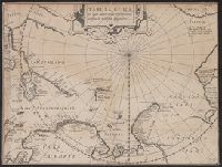
- Beinecke Rare Book and Manuscript Library > [Polus Antarcticus].
- Creator:
- Valck, G. (Gerard), 1651 or 2-1726
- Published / Created:
- [ca. 1695]
- Call Number:
- 70 1695
- Container / Volume:
- BRBL_00685
- Image Count:
- 1
- Resource Type:
- Maps, Atlases & Globes
- Found in:
- Beinecke Rare Book and Manuscript Library > L'Amérique Septentrionale & Meridionale divisée en ses principales parties, ou sont distingués les vns des autres les estats suivant qúils appartiennent presentement aux François, Castillans, Portugais, Anglois, Suedois, Danois, Hollandois &c / dress
- Creator:
- Goos, Pieter, approximately 1616-1675
- Published / Created:
- 1669?]
- Call Number:
- 183 1669
- Container / Volume:
- BRBL_00682
- Image Count:
- 1
- Resource Type:
- Maps, Atlases & Globes
- Found in:
- Beinecke Rare Book and Manuscript Library > Pascaerte van Groen-landt, Yslandt, Straet Davids [sic] en Ian Mayen Eylandt : hoemen de selvige van Hitlandt en de noort custen van Schotlandt en Yrlandt beseylen mach.
- Creator:
- Coronelli, Vincenzo, 1650-1718
- Published / Created:
- 1691]
- Call Number:
- 21 1690
- Container / Volume:
- BRBL_00682
- Image Count:
- 1
- Resource Type:
- Maps, Atlases & Globes
- Found in:
- Beinecke Rare Book and Manuscript Library > Mare del Nord / [cartographic material] / auttore il P.M. Coronelli M.C. cosmografo della serenissima Republica di Venetia.
- Creator:
- Pontanus, Johannes Isacius, 1571-1639
- Published / Created:
- 1611]
- Call Number:
- 18 1611
- Container / Volume:
- BRBL_00681
- Image Count:
- 1
- Resource Type:
- Maps, Atlases & Globes
- Found in:
- Beinecke Rare Book and Manuscript Library > Tabula geogr. in qua admirandae navigationis cursus et recursus designatur.
- Creator:
- Hondius, Hendrik, 1597-1651
- Published / Created:
- 1638?]
- Call Number:
- 19 1638
- Container / Volume:
- BRBL_00682
- Image Count:
- 1
- Resource Type:
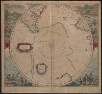
- Maps, Atlases & Globes
- Found in:
- Beinecke Rare Book and Manuscript Library > Polus Antarcticus / Henricus Hondius excudit.
- Creator:
- Blaeu, Willem Janszoon, 1571-1638, cartographer
- Published / Created:
- 1645]
- Call Number:
- 18 1645
- Container / Volume:
- BRBL_00681
- Image Count:
- 1
- Resource Type:
- Maps, Atlases & Globes
- Found in:
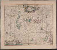
- Beinecke Rare Book and Manuscript Library > Regiones sub Polo Arctico / auctore Guiljelmo Blaeu.
- Creator:
- Wit, Frederik de
- Published / Created:
- [1675]
- Call Number:
- 21cea 1680
- Container / Volume:
- BRBL_00682
- Image Count:
- 1
- Resource Type:
- Maps, Atlases & Globes
- Found in:
- Beinecke Rare Book and Manuscript Library > Terra Nova ac maris tractus circa Novam Franciam, Angliam, Belgium, Venezuelam, Novam Andalusiam, Guianam, et Brasiliam / Apu[d] F. de Wit = Terra Neuf en de custen van Nieu Engeland, Nieu Nederland, Nieu Andalusia, Guiana en Venezuela / Fredrick de Wit.
- Creator:
- Robijn, Jacobus, d. ca. 1710
- Published / Created:
- [1683?]
- Call Number:
- 21 1683
- Container / Volume:
- BRBL_00682
- Image Count:
- 1
- Resource Type:
- Maps, Atlases & Globes
- Found in:
- Beinecke Rare Book and Manuscript Library > Pascaarte vande zee custen van Guinea en Brasilias van Cabo de Verde, tot C. de bona Esperanca en van R. de Amazones tot Rio de la Plata, alles op wassende graaden gestelt [cartographic material].