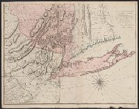
Map of Virginia, Maryland, New Jersey, New-York & New England and Mapp of New England
Description:
"Separate publication ca. 1673 ... Various dates have been assigned to the map, from 1673 to 1685" (McCorkle 33)., Inset: "A mapp of New England"., Relief shown p, and Reproduced in McCorkle, p. 33. Verso: Ink ms. annotations; numbered "57" in ink ms.
Publisher:
By John Thornton ... and by Robert Greene ... ,
Subject (Geographic):
Middle Atlantic States--Maps--Early works to 1800, New England--Maps--Early works to 1800, and New York (State)--Maps--Early works to 1800
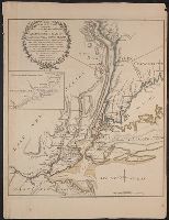
Author statement from McCorkle, p. 40., Includes ill. of animals and coat of arms., Relief shown pictorially., Verso: P. nos. "46", "45"; titles "The Description of New Neatherlands ... ", "The Description, and Verso: Stamped "Yale University Library".
Publisher:
Sold by Tho: Basset in Fleetstreet, and Richard Chiswell in St. Pauls Church Yard,
Subject (Geographic):
New England--Maps--Early works to 1800 and New York (State)--Maps--Early works to 1800
Subject (Name):
Bassett, Thomas, bookseller, Chiswell, Richard, Lamb, Francis, and Speed, John, 1552?-1629. Prospect of the most famous parts of the world
"Engrav'd for the Lond. Mag.", From The London magazine. v. 25; Sept. 1756, opp. p. 416., Inset: Fort Frederick at Crown Point built by the French 1731., and Prime meridian: London.
Publisher:
Printed for R. Baldwin in Pater Noster Row,
Subject (Geographic):
New Jersey--Maps--Early works to 1800 and New York (State)--Maps--Early works to 1800
Color: Pen and ink with green detail. and Reference on top right.
Subject (Geographic):
New York (State)--History--Revolution, 1775-1783--Maps--Early works to 1800, New York (State)--Maps--Early works to 1800, and United States--History--Revolution, 1775-1783--Maps--Early works to 1800