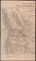
"Engraved and printed by McGill-Warner Co., Saint Paul.", Relief shown by hachures., and Shows lines running from Lake Michigan to Pacific Ocean through northern United States.
Publisher:
McGill-Warner Co.?,
Subject (Name):
Chicago, Milwaukee, and St. Paul Railway Company--Maps and McGill-Warner Co
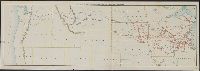
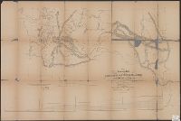
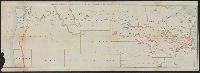
"Proof corrected in Office of P.R.R. Surveys, Feb 10th 1855. All copies printed prior to this date contain errors. G. K. Warren. Lieut. Topl. Engrs.", Description derived from published bibliography., and Sheet [1] From St Paul to Riviere des Lacs.--Sheet [2] From Riviere des Lacs to the Rocky Mountains.--Sheet [3] From the Rocky Mountains to Puget Sound.
Subject (Name):
Northern Pacific Railroad Company and Northern Pacific Railroad Company--Maps
Difference between the elevations of the Northern Pacific and the Union Pacific Railroads.
Description:
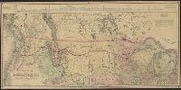
Covers northern United States from Lake Michigan to Pacific Ocean, and parts of Canada., Includes distance list, text, and profile of "Difference between the elevations of the Northern Pacific and the Union Pacific Railroads.", Relief shown by hachures and spot heights., and Shows cities and towns, coal fields, forts, isotherms, routes and trails, the railroad network and the proposed Northern Pacific Railroad. The line was constructed under an act of Congress approved by Abraham Lincoln, July 2, 1864. It was completed in 1883 and approximates the route of exploration taken by Lewis and Clark in 1804-06.
Publisher:
s.n.,
Subject (Name):
Northern Pacific Railroad Company and Northern Pacific Railroad Company--Maps
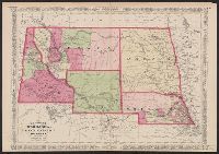
Date inferred from Nebraska counties--shows "Lyon," "Taylor," "Monroe," "Harrison," "Jackson," and "Grant" in southwest Nebraska (listed in 1870 Federal Census?) and Wayne County (formed 1871). Also shows Wyoming w and In upper left and right corners: 67, 68.
"Historical and statistical view of the United States 1860" (75, 76) on verso., Date inferred from Union Pacific-Central Pacific railroad shown incomplete; Laramie does not appear; an, and Library's copy annotated in pencil on verso: A.J. Johnson-New York-1867.
"Appendix to the geographical index" (77, 78) on verso., "Entered according to act of Congress in the year 1865 by A.J. Johnson in the clerk's office of the district court of the United States for the southern dis, and Relief shown by hachures and spot heights.
Map of the western United States showing drainage, cities and towns, military posts, railroads, and the Northern Pacific Railroad in red. Includes a profile of the line..