Skip to search
Skip to main content
Skip to first result
Search
You Searched For
Extent of Digitization
Completely digitized
Genre
Nautical charts
Search Results
Creator:
Published / Created:
25th, March 1775.
Call Number:
72cea 1775
Container / Volume:
BRBL_00688
Image Count:
1
Resource Type:
Maps, Atlases & Globes
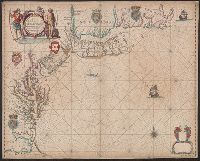
Description:
Depths shown by soundings.
Publisher:
Printed for & sold by Robt. Sayer & Jno. Bennett,
Subject (Geographic):
Grand Banks of Newfoundland--Maps--Early works to 1800
Subject (Name):
Chabert, Joseph Bernard, marquis de, 1724-1805, Cook, James, 1728-1779, Fleurieu, C. P. Claret (Charles Pierre Claret), comte de, 1738-1810, Jefferys, Thomas, d. 1771. American atlas, and Robert Sayer and John Benne
Subject (Topic):
Nautical charts--Newfoundland and Labrador--Grand Banks of Newfoundland--Early works to 1800
Found in:
Beinecke Rare Book and Manuscript Library > A chart of the Banks of Newfoundland / drawn from a great number of hydrographical surveys, chiefly from those of Chabert, Cook, and Fleurieu, connected and ascertained by astronomical observations.
Creator:
Published / Created:
25th, March 1775.
Call Number:
72cea 1775
Container / Volume:
BRBL_00373
Image Count:
1
Resource Type:
Maps, Atlases & Globes
Description:
Depths shown by soundings.
Publisher:
Printed for & sold by Robt. Sayer & Jno. Bennett,
Subject (Geographic):
Grand Banks of Newfoundland--Maps--Early works to 1800
Subject (Name):
Chabert, Joseph Bernard, marquis de,, Cook, James, 1728-1779, Fleurieu, C. P. Claret (Charles Pierre Claret), comte de, 1738-1810, Jefferys, Thomas, d. 1771. American atlas, and Robert Sayer and John Bennett (Firm)
Subject (Topic):
Nautical charts--Newfoundland and Labrador--Grand Banks of Newfoundland--Early works to 1800
Found in:
Beinecke Rare Book and Manuscript Library > A chart of the Banks of Newfoundland / drawn from a great number of hydrographical surveys, chiefly from those of Chabert, Cook, and Fleurieu, connected and ascertained by astronomical observations.
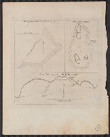
Creator:
Published / Created:
[1862], c1852
Call Number:
21cea 1862
Image Count:
1
Resource Type:
Maps, Atlases & Globes
Alternative Title:
Chesapeake and Delaware Bays.
Description:
"Drawn by F. Lucas, Jr."
Publisher:
Fielding Lucas,
Subject (Geographic):
Chesapeake Bay Region (Md. and Va.)--Maps and Delaware Bay Region (Del. and N.J.)--Maps
Subject (Topic):
Coasts--Delaware--Maps, Coasts--Maryland--Maps, Coasts--New Jersey--Maps, and Coasts--Virginia--Maps
Found in:
Beinecke Rare Book and Manuscript Library > A chart of the Chesapeake and Delaware Bays / compiled and published by Fielding Lucas.
Creator:
Published / Created:
25th March, 1775.
Call Number:
7345cea 1775A
Container / Volume:
BRBL_00689
Image Count:
1
Resource Type:
Maps, Atlases & Globes
Description:
From Jefferys's The American atlas ... London : Printed and sold by R. Sayer and J. Bennett, 1776.
Publisher:
Printed & sold by Robt. Sayer & Jno. Bennett,
Subject (Geographic):
Saint Lawrence, Gulf of--Maps--Early works to 1800
Subject (Name):
Jefferys, Thomas, -1771. American atlas and Robert Sayer and John Bennett (Firm)
Subject (Topic):
Nautical charts--Saint Lawrence, Gulf of--Early works to 1800
Found in:
Beinecke Rare Book and Manuscript Library > A chart of the Gulf of St. Laurence [cartographic material] : composed from a great number of actual surveys and other materials, regulated and connected by astronomical observations.
Creator:
Published / Created:
June 28th, 1780.
Call Number:
39cea 1780
Container / Volume:
BRBL_00192
Image Count:
1
Resource Type:
Maps, Atlases & Globes
Description:
Also appeared in Faden's General atlas. London : William Faden, 1811?.
Publisher:
Engraved & published by Wm. Faden,
Subject (Geographic):
Mediterranean Sea--Maps--Early works to 1800
Subject (Name):
Abbot, Charles,--Baron Colchester,--1757-1829--Bookplate and Faden, William, 1749-1836. General atlas
Subject (Topic):
Coasts--Africa, North--Maps--Early works to 1800, Coasts--Portugal--Maps--Early works to 1800, Coasts--Spain--Maps--Early works to 1800, Nautical charts--Africa, North--Early works to 1800, and Nautical charts--Medi
Found in:
Beinecke Rare Book and Manuscript Library > A chart of the coasts of Spain and Portugal, with the Balearic Islands, and part of the coast of Barbary / by L.S. De la Rochette.
Creator:
Published / Created:
1759?]
Call Number:
732cea H13 1759
Container / Volume:
BRBL_00378
Image Count:
1
Resource Type:
Maps, Atlases & Globes
Description:
"Published by command of the Right Honourable the Lords of Trade & Plantations, for the benefit of the trade and navigation of Great Britain and its colonies."
Publisher:
[Thomas Jefferys?,
Subject (Geographic):
Halifax Harbour (N.S.)--Maps--Early works to 1800
Subject (Name):
Jefferys, Thomas, d. 1771
Subject (Topic):
Harbors--Nova Scotia--Halifax--Maps--Early works to 1800, Nautical charts--Nova Scotia--Halifax Harbour--Early works to 1800, and Nautical charts--Nova Scotia--Halifax--Early works to 1800
Found in:
Beinecke Rare Book and Manuscript Library > A chart of the harbour of Halifax, in Nova Scotia : with Jebucto Bay and Cape Sambrô, also the islands, ledges of rocks, shoals & soundings / survey'd, by order of His Excellency Brigadier General Lawrence, Governour of the Province of Nova Scotia, by Ch
Creator:
Published / Created:
31 Augst. 1780.
Call Number:
8555 1780A
Container / Volume:
BRBL_00695
Image Count:
1
Resource Type:
Maps, Atlases & Globes
Description:
Cross Collection no. 288.
Publisher:
By J. Bew,
Subject (Geographic):
Jamaica--Maps--Early works to 1800
Subject (Name):
Bew, John, -1793, publisher
Subject (Topic):
Harbors--Jamaica--Maps--Early works to 1800
Found in:
Beinecke Rare Book and Manuscript Library > A chart of the island of Jamaica [cartographic material] : with its bays, harbours, rocks, soundings, &c. / Jno. Lodge, sculp.
Creator:
Published / Created:
1675?]
Call Number:
755cea 1675
Container / Volume:
BRBL_00441
Image Count:
1
Resource Type:
Maps, Atlases & Globes
Description:
Appears in: John Seller, Atlas maritimus, 1675 (McCorkle 36).
Subject (Geographic):
Middle Atlantic States--Nautical charts--Early works to 1800 and New England--Nautical charts--Early works to 1800
Subject (Name):
Clerk, James, fl. 1680-1695 and Seller, John, fl. 1658-1698. Atlas maritimus
Found in:
Beinecke Rare Book and Manuscript Library > A chart of the sea coasts of New-England, New-Jarsey, Virginia, Maryland and Carolina : from C. Cod to C. Hatteras / by John Seller, hydrogr. to the King ; Iames Clerk sculpsit.
Creator:
Published / Created:
[1671?]
Call Number:
319cea 1671
Container / Volume:
BRBL_00042
Image Count:
1
Resource Type:
Maps, Atlases & Globes
Description:
Copper engraving, colored to show coasts of Eng.
Publisher:
John Seller,
Subject (Geographic):
British Isles--Maps--Early works to 1800
Found in:
Beinecke Rare Book and Manuscript Library > A chart of ye narrow seas / newly corrected by John Seller, hydrographer to the kings most excellent majestie.
Creator:
Published / Created:
[1773]
Call Number:
282 1767
Collection Title:
Account of the voyages undertaken by the order of His present Majesty for making discoveries in the
Container / Volume:
BRBL_00683
Image Count:
1
Resource Type:
Maps, Atlases & Globes
Alternative Title:
Joseph Freewills Islands. and South end of Mindanao.
Description:
Cross Collection 71.
Subject (Geographic):
Mapia Islands (Indonesia)--Maps--Early works to 1800 and Mindanao Island (Philippines)--Maps--Early works to 1800
Subject (Name):
Carteret, Philip, d. 1796 and Cook, James, 1728-1779
Subject (Topic):
Nautical charts--Indonesia--Mapia Island--Early works to 1800 and Nautical charts--Philippines--Mindanao Island--Early works to 1800
Found in:
Beinecke Rare Book and Manuscript Library > A dangerous shoal seen Septr. the 28, 1767 [cartographic material] : The south end of Mindanao ; Joseph Freewills Islands.
Branch:v1.68.6 ,Deployed:2025-07-02T08:09:52-04:00