Skip to search
Skip to main content
Skip to first result
Yale University Library
Ask Yale Library
Reserve Rooms
Places to Study
Research
Quicksearch
Search Library Catalog (Orbis)
Search Law Library Catalog (MORRIS)
Search Borrow Direct
Search WorldCat
Search Articles+
Search Digital Collections
Search Archives at Yale
Research Guides
Find Databases by Title
Find eJournals by Title
Guide to Using Special Collections
Services
Your Personal Librarian
Subject Specialists
Research Support and Workshops
Citation Tools
OverDrive: Popular Audio and eBooks
Get It @ Yale (Borrow Direct, Interlibrary Loan, Scan & Deliver)
Course Reserves
Off-Campus Access
EliScholar
OverDrive: Popular Audio and eBooks
Bass Media Equipment
Libraries & Collections
Arts Library
Bass Library
Beinecke Library
Classics Library
Divinity Library
Film Study Center
Fortunoff Archive
Humanities Collections
International Collections
Law Library
Lewis Walpole Library
Library Collection Services
Manuscripts & Archives
Map Collection
Marx Science & Social Science Library
Medical Library
Music Library
Sterling Library
Yale Center for British Art
Information & Policies
Library Hours
Departments & Staff
Borrowing & Circulation
Services for Persons with Disabilities
Copyright Basics
Scanning, Printing & Copying
Computers & Wireless
Library Policies
About the Library
Giving to the Library
Purchase Request
Working at the Library
Terms Governing Use of Materials
Search in
All Fields
Creator
Title
Call Number
Date
Subject
Orbis ID
Full Text
Description
Full text
search for
Search
Search
Advanced Search
Digital Collections
Search
You Searched For
Genre
Maps
Genre
Maps in books
Genre
Prints (Visual works)
New Search
« Previous
|
1
-
99
of
127
|
Next »
Sort
by relevance
relevance
Creator (A --> Z)
Creator (Z --> A)
Title (A --> Z)
Title (Z --> A)
Year (ascending)
Year (descending)
Number of results to display per page
99
per page
9
per page
30
per page
60
per page
99
per page
View results as:
List
List
Gallery
Gallery
Search Results
Voyages & [i.e., et] aventures d’un Berrichon a la recherche d’une position sociale, par A. Artaud ...
A new map of that part of Africacalled the coast of Guinea ...
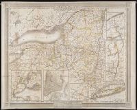
Connecticut from the best authorities
9. Connecticut
Nova Belgica et Anglia Nova
Limite inferieure des Neiges perpetuelles a differentes Latitudes
Tableau physique des Ils Canaries. Geographie des plantes du Pic de Teneriffe
Profit du Chemin de Carthagene des Indes au Plateau de Santa Fe de Bogata. pl. 6
Carte du Cours de Rio Apure et d'une Partie de la Chaine des Montaignes de la Nouvelle Grenade
Carte du Rio Grande de la Magdalena depuis le 4 [degrees] Latitude jusqu'a son embouchure. No. 24
Carte de la Vallee de Mexico et des Montagnes Voisines esquissee sur les Lieux en 1804, par Don
Tableau physique de la pente Orientale du Plateau de la Nouvelle Espagne (Chemin de Mexico a
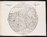
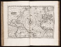
Nova, et integra universi orbis descriptio
Tableau du Plateau central des Montagnes du Mexique, entre les 19 et 21 [degree] de Latitude
Profit du Canal de Huehuetoca (Desague Real.) Creuse pour preserver la Ville de Mexico du danger
Nvevo Mvndo
Vraye & exacte description hydrographique des costes maritimes dEscosse & des Isles Orchades
Typus cosmographicus universalis
Typus cosmographicus universalis
Terza Tavola
Seconda Tavola
Prima Tavola
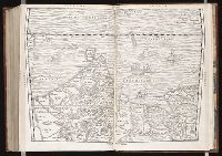
La Nuova Francia
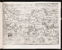
Brasil
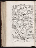
Parte de la Africa
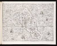
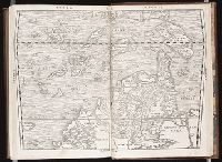
Sumatra
Universale della parte del mondo, nuouamente ritrovata
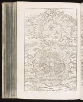
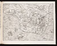
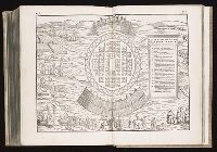
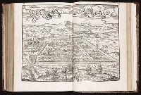
Mexico [City]
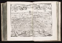
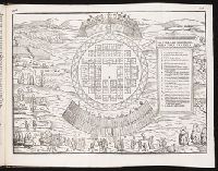
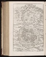
Il Cvscho, citta principale della provincia del Perv.
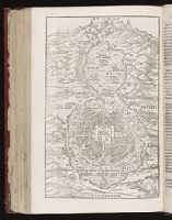
Mexico [City]
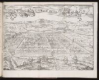
Il Cvscho, citta principale della provincia del Perv.
La Nuova Francia
Brasil
Parte de la Africa
Sumatra
La terra Hochelaga nella Nova Francia
La terra Hochelaga nella Nova Francia
Universale della parte del mondo, nuouamente ritrovata
Mexico [City]
Il Cvscho, citta principale della provincia del Perv.
La Nuova Francia
Brasil
Parte de la Africa
Sumatra
La terra Hochelaga nella Nova Francia
[Map of Africa]
Prima Tavola
Seconda Tavola
Terza Tavola
Novueau monde
Typvs cosmographicvs vniversalis
A chart and map of the Gold Coast of Guinea from Rio da Corsa to Ro da Volta. vol. V [5], pl. K
Florida, et regiones vicinae
Nova Hispanica, Nova Galicia, Guatimala
Chili
Paraguay, O Prov. de Rio de la Plata cum adiacentibus Provinviis quas vocant Tucuman, et Sta. Cruz
Plan del Presidio dens de los Dolores
Presidio de n.s. de Loreto en la Bahia
A chart of the Bahamas Islands with a description of the Gulf of Florida and Windward passage &c
Carte de la Nouuelle France, augmentee depuis la derniere, seruant a la navigation faicte en son
A particular platt, for sailing to the Azores
Carte generall de la Nouvelle France ou est compris la LouisianeGaspesie et le Nouvelle Mexique
A map of Lewis and Clark's track, across the western portion of North America fom the Mississippi
A Map of the world, on wch is delineated the voyages of Robinson Cruso
The Virgin Islands from English and Danish surveys
Curacao from the Dutch originals of Gerard Van Keulen
The island of Hispaniola called by the French St. Domingo. Subject to France and Spain
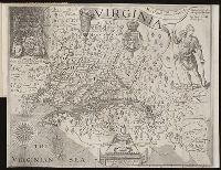
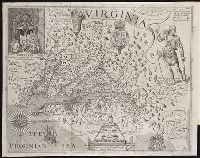
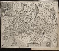
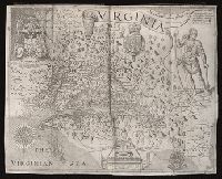
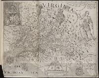
Virginia discouered and described by Captayn John Smith
Kaart van Nieuw Vrankryk, en van Louisania...
Carte d'un nouueau monde, entre le nouueau Mexique et la mer glacialle
Virginia discouered and described by Captayn John Smith
The Summer Ils
A general map of the middle British colonies in America
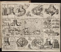
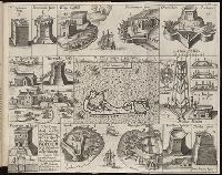
A description of part of the adventures of Cap. Smith in Virginia
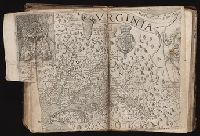
Virginia
The Summer Ils
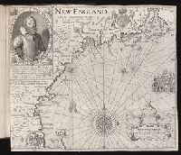
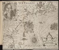
New England.
A general map of the middle British colonies in America
A general map of the middle British colonies in America
Britannia
Virginia
[New England]
New England.
Summer Ils
Ould Virginia
Virginia
Summer Ils
Ould Virginia
An exact mapp of New England and New York
The phenomena of the universe ...
Map of the United Kingdom of Great Britain and Ireland
New-York
Ould Virginia
Virginia
Summer Ils
New England.
Lengths of the principal rivers in the world
A new map of Maine
A new map of Maine
PREVIOUS
«
1
2
»
NEXT
Limit your search
Extent of Digitization
Unspecified
66
Partially digitized
60
Completely digitized
1
Access
Public
127
Repository
Beinecke Rare Book and Manuscript Library
127
Format
cartographic
117
still image
6
mixed material
4
Genre
Maps
✖
[remove]
127
Maps in books
✖
[remove]
127
Prints (Visual works)
✖
[remove]
127
Engravings
96
Illustrations
39
Woodcuts
27
Bird's-eye views
10
Hand coloring
10
Atlases
5
Intaglio prints
3
more
Genre
»
Resource Type
Maps, Atlases & Globes
45
Books, Journals & Pamphlets
2
Prints & Photographs
2
Language
English
11
Italian
2
Latin
1
Creator
Hole, William, d. 1624, engraver
6
Vaughan, Robert, 17th cent., engraver
5
Smith, John, 1580-1631
3
Clarke, Robert, fl. 1616
2
Evans, Lewis, 1700?-1756.
2
Grynaus, Simon, 1493-1541
2
Nicolay, Nicolas de, 1517-1583
2
Pass, Simon van de, 1595?-1647, engraver.
2
Reeve, James, printer
2
Reeve, James, printer.
2
more
Creator
»
Subject (Topic)
Voyages and travels
12
Discoveries in geography.
6
Discoveries in geography
5
Explorers
5
Fortifications
5
Indians of North America --Virginia --Early works to 1800.
5
Scientific expeditions
5
Voyages and travels.
5
Bridges
4
Fortification.
4
more
Subject (Topic)
»
Subject (Name)
P.S. Duval & Son
2
Smith, John, 1580-1631
2
Clarke, Robert, fl. 1616
1
Pasaeus, Simon
1
Reeve, James
1
Publication Place
In Venetia
30
London
4
Berlin, Paris
1
Boston
1
Bourges
1
London,
1
Mexico, Berlin
1
New York
1
Paris
1
Philadelphia
1
more
Publication Place
»
Date Created
View distribution
Current results range from
1531
to
1877
Date Created range begin
Date Created range end
View larger »
[Missing]
33