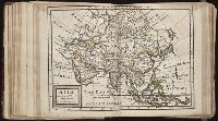
Twenty four new and accurate maps of the several parts of Europe ... : all (except the last) new
Image Count:
1
Alternative Title:
The world in general
Description:
In pencil on verso: 1.
Subject (Name):
Barker, B. (Benjamin), d. 1764, bookseller, Clements, Henry, d. 1719, bookseller, King, Charles, d. 1735, bookseller, Nicholson, John, d. ca. 1717, bookseller, Parker, Richard, fl. 1692-1725, bookseller, and Tooke, Benjamin, d. 1716, bookseller
Subject (Topic):
Atlases --Early works to 1800 and World maps --Early works to 1800
Collection Created:
[London] : Sold by J. Nicholson at the King’s-Arms in Little Britain, Benj. Barker and Charles King ..., Benj. Tooke ..., Hen. Clements ..., R. Parker and Ralph Smith under the Royal-Exchange ..., [1715?]
Twenty four new and accurate maps of the several parts of Europe ... : all (except the last) new
Image Count:
1
Alternative Title:
Europe in particular
Description:
In pencil on verso: 2.
Subject (Geographic):
Europe --Maps --Early works to 1800
Subject (Name):
Barker, B. (Benjamin), d. 1764, bookseller, Clements, Henry, d. 1719, bookseller, King, Charles, d. 1735, bookseller, Nicholson, John, d. ca. 1717, bookseller, Parker, Richard, fl. 1692-1725, bookseller, and Tooke, Benjamin, d. 1716, bookseller
Subject (Topic):
Atlases --Early works to 1800
Collection Created:
[London] : Sold by J. Nicholson at the King’s-Arms in Little Britain, Benj. Barker and Charles King ..., Benj. Tooke ..., Hen. Clements ..., R. Parker and Ralph Smith under the Royal-Exchange ..., [1715?]
Twenty four new and accurate maps of the several parts of Europe ... : all (except the last) new
Image Count:
1
Alternative Title:
Sweden and Norway
Description:
In pencil on verso: 3.
Subject (Geographic):
Norway --Maps --Early works to 1800 and Sweden --Maps
Subject (Name):
Barker, B. (Benjamin), d. 1764, bookseller, Clements, Henry, d. 1719, bookseller, King, Charles, d. 1735, bookseller, Nicholson, John, d. ca. 1717, bookseller, Parker, Richard, fl. 1692-1725, bookseller, and Tooke, Benjamin, d. 1716, bookseller
Subject (Topic):
Atlases --Early works to 1800
Collection Created:
[London] : Sold by J. Nicholson at the King’s-Arms in Little Britain, Benj. Barker and Charles King ..., Benj. Tooke ..., Hen. Clements ..., R. Parker and Ralph Smith under the Royal-Exchange ..., [1715?]
Twenty four new and accurate maps of the several parts of Europe ... : all (except the last) new
Image Count:
1
Alternative Title:
Denmark
Description:
In pencil on verso: 4.
Subject (Geographic):
Denmark --Maps --Early works to 1800
Subject (Name):
Barker, B. (Benjamin), d. 1764, bookseller, Clements, Henry, d. 1719, bookseller, King, Charles, d. 1735, bookseller, Nicholson, John, d. ca. 1717, bookseller, Parker, Richard, fl. 1692-1725, bookseller, and Tooke, Benjamin, d. 1716, bookseller
Subject (Topic):
Atlases --Early works to 1800
Collection Created:
[London] : Sold by J. Nicholson at the King’s-Arms in Little Britain, Benj. Barker and Charles King ..., Benj. Tooke ..., Hen. Clements ..., R. Parker and Ralph Smith under the Royal-Exchange ..., [1715?]
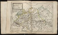
Twenty four new and accurate maps of the several parts of Europe ... : all (except the last) new
Image Count:
1
Alternative Title:
Muscovy, or Russia
Description:
In pencil on verso: 5.
Subject (Geographic):
Russia --Maps --Early works to 1800
Subject (Name):
Barker, B. (Benjamin), d. 1764, bookseller, Clements, Henry, d. 1719, bookseller, King, Charles, d. 1735, bookseller, Nicholson, John, d. ca. 1717, bookseller, Parker, Richard, fl. 1692-1725, bookseller, and Tooke, Benjamin, d. 1716, bookseller
Subject (Topic):
Atlases --Early works to 1800
Collection Created:
[London] : Sold by J. Nicholson at the King’s-Arms in Little Britain, Benj. Barker and Charles King ..., Benj. Tooke ..., Hen. Clements ..., R. Parker and Ralph Smith under the Royal-Exchange ..., [1715?]
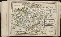
Twenty four new and accurate maps of the several parts of Europe ... : all (except the last) new
Image Count:
1
Alternative Title:
Poland
Description:
In pencil on verso: 6.
Subject (Geographic):
Poland --Maps --Early works to 1800
Subject (Name):
Barker, B. (Benjamin), d. 1764, bookseller, Clements, Henry, d. 1719, bookseller, King, Charles, d. 1735, bookseller, Nicholson, John, d. ca. 1717, bookseller, Parker, Richard, fl. 1692-1725, bookseller, and Tooke, Benjamin, d. 1716, bookseller
Subject (Topic):
Atlases --Early works to 1800
Collection Created:
[London] : Sold by J. Nicholson at the King’s-Arms in Little Britain, Benj. Barker and Charles King ..., Benj. Tooke ..., Hen. Clements ..., R. Parker and Ralph Smith under the Royal-Exchange ..., [1715?]
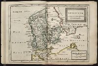
Twenty four new and accurate maps of the several parts of Europe ... : all (except the last) new
Image Count:
1
Alternative Title:
Germany in general
Description:
In pencil on verso: 7.
Subject (Geographic):
Germany --Maps --Early works to 1800
Subject (Name):
Barker, B. (Benjamin), d. 1764, bookseller, Clements, Henry, d. 1719, bookseller, King, Charles, d. 1735, bookseller, Nicholson, John, d. ca. 1717, bookseller, Parker, Richard, fl. 1692-1725, bookseller, and Tooke, Benjamin, d. 1716, bookseller
Subject (Topic):
Atlases --Early works to 1800
Collection Created:
[London] : Sold by J. Nicholson at the King’s-Arms in Little Britain, Benj. Barker and Charles King ..., Benj. Tooke ..., Hen. Clements ..., R. Parker and Ralph Smith under the Royal-Exchange ..., [1715?]
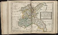
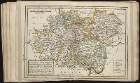
Twenty four new and accurate maps of the several parts of Europe ... : all (except the last) new
Image Count:
1
Alternative Title:
The north-east part of Germany, containing the dutchies of Mecklenburg and Pomerania, Brandenburgh, Saxony, Silesia, the marquisate of Lusatia, &c
Description:
In pencil on verso: 8.
Subject (Geographic):
Brandenburg (Brandenburg, Germany) --Maps --Early works to 1800, Germany --Maps --Early works to 1800, Lusatia (Germany) --Maps --Early works to 1800, Mecklenburg (Germany : Region) --Maps --Early works to 1800, Pomerania (Poland and Germany) --Maps --Early works to 1800, Saxony (Germany) --Maps --Early works to 1800, and Silesia, Lower (Poland and Germany) --Maps
Subject (Name):
Barker, B. (Benjamin), d. 1764, bookseller, Clements, Henry, d. 1719, bookseller, King, Charles, d. 1735, bookseller, Nicholson, John, d. ca. 1717, bookseller, Parker, Richard, fl. 1692-1725, bookseller, and Tooke, Benjamin, d. 1716, bookseller
Subject (Topic):
Atlases --Early works to 1800
Collection Created:
[London] : Sold by J. Nicholson at the King’s-Arms in Little Britain, Benj. Barker and Charles King ..., Benj. Tooke ..., Hen. Clements ..., R. Parker and Ralph Smith under the Royal-Exchange ..., [1715?]
Twenty four new and accurate maps of the several parts of Europe ... : all (except the last) new
Image Count:
1
Alternative Title:
The north-west part of Germany, containing Cologne, Westphalia, Juliers, Cleeves, Munster, Osnaburgh, Holstein, Bremen, Hanover, Lunenburgh and Brunswick, Hesse-Cassel, &c
Description:
In pencil on verso: 9.
Subject (Geographic):
Bremen (Germany) --Maps, Cologne (Germany) --Maps --Early works to 1800, Emden (Lower Saxony, Germany) --Maps, Germany --Maps --Early works to 1800, Hesse-Kassel (Electorate), Muenster (Germany : Regierungsbezirk) --Maps, Osnabrueck (Germany) --Maps, and Westphalia (Germany) --Maps
Subject (Name):
Barker, B. (Benjamin), d. 1764, bookseller, Clements, Henry, d. 1719, bookseller, King, Charles, d. 1735, bookseller, Nicholson, John, d. ca. 1717, bookseller, Parker, Richard, fl. 1692-1725, bookseller, and Tooke, Benjamin, d. 1716, bookseller
Subject (Topic):
Atlases --Early works to 1800
Collection Created:
[London] : Sold by J. Nicholson at the King’s-Arms in Little Britain, Benj. Barker and Charles King ..., Benj. Tooke ..., Hen. Clements ..., R. Parker and Ralph Smith under the Royal-Exchange ..., [1715?]
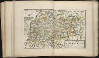
Twenty four new and accurate maps of the several parts of Europe ... : all (except the last) new
Image Count:
1
Alternative Title:
The south-east part of Germany, viz. Bavaria, Newburgh, Saltzburgh, Bohemia, Moravia, Austria, Styria, Carinthia, Carniola, Brixen, Trent, Tirol, &c
Description:
In pencil on verso: 10.
Subject (Geographic):
Austria --Maps --Early works to 1800, Bavaria (Germany) --Maps --Early works to 1800, Bohemia and Moravia (Protectorate, 1939-1945), Germany --Maps --Early works to 1800, and Styria (Austria) --Maps
Subject (Name):
Barker, B. (Benjamin), d. 1764, bookseller, Clements, Henry, d. 1719, bookseller, King, Charles, d. 1735, bookseller, Nicholson, John, d. ca. 1717, bookseller, Parker, Richard, fl. 1692-1725, bookseller, and Tooke, Benjamin, d. 1716, bookseller
Subject (Topic):
Atlases --Early works to 1800
Collection Created:
[London] : Sold by J. Nicholson at the King’s-Arms in Little Britain, Benj. Barker and Charles King ..., Benj. Tooke ..., Hen. Clements ..., R. Parker and Ralph Smith under the Royal-Exchange ..., [1715?]
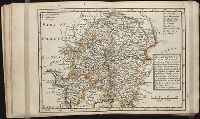
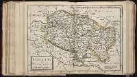
Twenty four new and accurate maps of the several parts of Europe ... : all (except the last) new
Image Count:
1
Alternative Title:
Swabia and Franconia, with the Duke of Marlborough's march to Hochstet, &c
Description:
In pencil on verso: 12.
Subject (Geographic):
Franconia (Germany) --Maps, Germany --Maps --Early works to 1800, and Swabia (Germany) --Maps --Early works to 1800
Subject (Name):
Barker, B. (Benjamin), d. 1764, bookseller, Clements, Henry, d. 1719, bookseller, King, Charles, d. 1735, bookseller, Nicholson, John, d. ca. 1717, bookseller, Parker, Richard, fl. 1692-1725, bookseller, and Tooke, Benjamin, d. 1716, bookseller
Subject (Topic):
Atlases --Early works to 1800
Collection Created:
[London] : Sold by J. Nicholson at the King’s-Arms in Little Britain, Benj. Barker and Charles King ..., Benj. Tooke ..., Hen. Clements ..., R. Parker and Ralph Smith under the Royal-Exchange ..., [1715?]
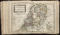
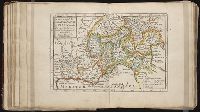
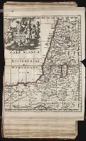
Twenty four new and accurate maps of the several parts of Europe ... : all (except the last) new
Image Count:
1
Alternative Title:
The United-Provinces, or Netherlands
Description:
In pencil on verso: 13.
Subject (Geographic):
Netherlands --Maps --Early works to 1800
Subject (Name):
Barker, B. (Benjamin), d. 1764, bookseller, Clements, Henry, d. 1719, bookseller, King, Charles, d. 1735, bookseller, Nicholson, John, d. ca. 1717, bookseller, Parker, Richard, fl. 1692-1725, bookseller, and Tooke, Benjamin, d. 1716, bookseller
Subject (Topic):
Atlases --Early works to 1800
Collection Created:
[London] : Sold by J. Nicholson at the King’s-Arms in Little Britain, Benj. Barker and Charles King ..., Benj. Tooke ..., Hen. Clements ..., R. Parker and Ralph Smith under the Royal-Exchange ..., [1715?]
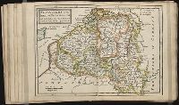
Twenty four new and accurate maps of the several parts of Europe ... : all (except the last) new
Image Count:
1
Alternative Title:
Flanders, or the Spanish Netherlands; with the bishopricks of Cambray and Liege
Description:
In pencil on verso: 14.
Subject (Geographic):
Flanders (Belgium) --Maps --Early works to 1800
Subject (Name):
Barker, B. (Benjamin), d. 1764, bookseller, Clements, Henry, d. 1719, bookseller, King, Charles, d. 1735, bookseller, Nicholson, John, d. ca. 1717, bookseller, Parker, Richard, fl. 1692-1725, bookseller, and Tooke, Benjamin, d. 1716, bookseller
Subject (Topic):
Atlases --Early works to 1800
Collection Created:
[London] : Sold by J. Nicholson at the King’s-Arms in Little Britain, Benj. Barker and Charles King ..., Benj. Tooke ..., Hen. Clements ..., R. Parker and Ralph Smith under the Royal-Exchange ..., [1715?]
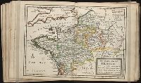
Twenty four new and accurate maps of the several parts of Europe ... : all (except the last) new
Image Count:
1
Alternative Title:
France in general
Description:
In pencil on verso: 15.
Subject (Geographic):
France --Maps --Early works to 1800
Subject (Name):
Barker, B. (Benjamin), d. 1764, bookseller, Clements, Henry, d. 1719, bookseller, King, Charles, d. 1735, bookseller, Nicholson, John, d. ca. 1717, bookseller, Parker, Richard, fl. 1692-1725, bookseller, and Tooke, Benjamin, d. 1716, bookseller
Subject (Topic):
Atlases --Early works to 1800
Collection Created:
[London] : Sold by J. Nicholson at the King’s-Arms in Little Britain, Benj. Barker and Charles King ..., Benj. Tooke ..., Hen. Clements ..., R. Parker and Ralph Smith under the Royal-Exchange ..., [1715?]
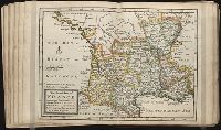
Twenty four new and accurate maps of the several parts of Europe ... : all (except the last) new
Image Count:
1
Alternative Title:
The north part of France, viz. Picardy, Normandy, Bretagne, Isle de France, Champagne and Orleanois
Description:
In pencil on verso: 16.
Subject (Geographic):
Champagne-Ardenne (France) --Maps, France --Maps --Early works to 1800, Normandy (France) --Maps --Early works to 1800, and Picardy (France) --Maps
Subject (Name):
Barker, B. (Benjamin), d. 1764, bookseller, Clements, Henry, d. 1719, bookseller, King, Charles, d. 1735, bookseller, Nicholson, John, d. ca. 1717, bookseller, Parker, Richard, fl. 1692-1725, bookseller, and Tooke, Benjamin, d. 1716, bookseller
Subject (Topic):
Atlases --Early works to 1800
Collection Created:
[London] : Sold by J. Nicholson at the King’s-Arms in Little Britain, Benj. Barker and Charles King ..., Benj. Tooke ..., Hen. Clements ..., R. Parker and Ralph Smith under the Royal-Exchange ..., [1715?]
Twenty four new and accurate maps of the several parts of Europe ... : all (except the last) new
Image Count:
1
Alternative Title:
The south part of France, viz. Burgundy, Lyonois, Guienne, Languedoc, Dauphine and Provence
Description:
In pencil on verso: 17.
Subject (Geographic):
Burgundy (France) --Maps --Early works to 1800, Dauphine (France) --Maps, France --Maps --Early works to 1800, Guyenne (France) --Maps, Languedoc (France) --Maps --Early works to 1800, Lyon (France) --Maps, and Provence-Alpes-Cote d'Azur (France) --Maps
Subject (Name):
Barker, B. (Benjamin), d. 1764, bookseller, Clements, Henry, d. 1719, bookseller, King, Charles, d. 1735, bookseller, Nicholson, John, d. ca. 1717, bookseller, Parker, Richard, fl. 1692-1725, bookseller, and Tooke, Benjamin, d. 1716, bookseller
Subject (Topic):
Atlases --Early works to 1800
Collection Created:
[London] : Sold by J. Nicholson at the King’s-Arms in Little Britain, Benj. Barker and Charles King ..., Benj. Tooke ..., Hen. Clements ..., R. Parker and Ralph Smith under the Royal-Exchange ..., [1715?]
Twenty four new and accurate maps of the several parts of Europe ... : all (except the last) new
Image Count:
1
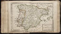
Description:
In pencil on verso: 18.
Subject (Geographic):
Portugal --Maps --Early works to 1800 and Spain --Maps --Early works to 1800
Subject (Name):
Barker, B. (Benjamin), d. 1764, bookseller, Clements, Henry, d. 1719, bookseller, King, Charles, d. 1735, bookseller, Nicholson, John, d. ca. 1717, bookseller, Parker, Richard, fl. 1692-1725, bookseller, and Tooke, Benjamin, d. 1716, bookseller
Subject (Topic):
Atlases --Early works to 1800
Collection Created:
[London] : Sold by J. Nicholson at the King’s-Arms in Little Britain, Benj. Barker and Charles King ..., Benj. Tooke ..., Hen. Clements ..., R. Parker and Ralph Smith under the Royal-Exchange ..., [1715?]
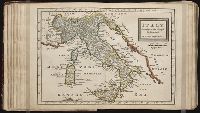
Twenty four new and accurate maps of the several parts of Europe ... : all (except the last) new
Image Count:
1
Alternative Title:
Italy in general, with Naples, the Isle of Sicily, &c
Description:
In pencil on verso: 19.
Subject (Geographic):
Italy --Maps --Early works to 1800, Naples (Italy) --Maps --Early works to 1800, and Sicily (Italy) --Maps --Early works to 1800
Subject (Name):
Barker, B. (Benjamin), d. 1764, bookseller, Clements, Henry, d. 1719, bookseller, King, Charles, d. 1735, bookseller, Nicholson, John, d. ca. 1717, bookseller, Parker, Richard, fl. 1692-1725, bookseller, and Tooke, Benjamin, d. 1716, bookseller
Subject (Topic):
Atlases --Early works to 1800
Collection Created:
[London] : Sold by J. Nicholson at the King’s-Arms in Little Britain, Benj. Barker and Charles King ..., Benj. Tooke ..., Hen. Clements ..., R. Parker and Ralph Smith under the Royal-Exchange ..., [1715?]
Twenty four new and accurate maps of the several parts of Europe ... : all (except the last) new
Image Count:
1
Alternative Title:
The English Channel; with the coasts of England, France, and Holland
Description:
In pencil on verso: 20. and Table of contents for maps 20-24 misnumbered.
Subject (Geographic):
Cevennes Mountains (France) --Maps, Dauphine´ Alps (France), England --Maps --To 1800, France --Maps --Early works to 1800, Lombardy (Italy) --Maps --Early works to 1800, Netherlands --Maps --Early works to 1800, and Provence-Alpes-Cote d'Azur (France) --Maps
Subject (Name):
Barker, B. (Benjamin), d. 1764, bookseller, Clements, Henry, d. 1719, bookseller, King, Charles, d. 1735, bookseller, Nicholson, John, d. ca. 1717, bookseller, Parker, Richard, fl. 1692-1725, bookseller, and Tooke, Benjamin, d. 1716, bookseller
Subject (Topic):
Atlases --Early works to 1800
Collection Created:
[London] : Sold by J. Nicholson at the King’s-Arms in Little Britain, Benj. Barker and Charles King ..., Benj. Tooke ..., Hen. Clements ..., R. Parker and Ralph Smith under the Royal-Exchange ..., [1715?]
Twenty four new and accurate maps of the several parts of Europe ... : all (except the last) new
Image Count:
1
Alternative Title:
Lombardy, with Dauphine, Provence, the Cevennes, &c
Description:
In pencil on verso: 21. and Table of contents for maps 20-24 misnumbered.
Subject (Geographic):
Cevennes Mountains (France) --Maps, Dauphine Alps (France), France --Maps --Early works to 1800, Graubuenden (Switzerland), Italy --Maps --Early works to 1800, and Switzerland --Maps --Early works to 1800
Subject (Name):
Barker, B. (Benjamin), d. 1764, bookseller, Clements, Henry, d. 1719, bookseller, King, Charles, d. 1735, bookseller, Nicholson, John, d. ca. 1717, bookseller, Parker, Richard, fl. 1692-1725, bookseller, and Tooke, Benjamin, d. 1716, bookseller
Subject (Topic):
Atlases --Early works to 1800
Collection Created:
[London] : Sold by J. Nicholson at the King’s-Arms in Little Britain, Benj. Barker and Charles King ..., Benj. Tooke ..., Hen. Clements ..., R. Parker and Ralph Smith under the Royal-Exchange ..., [1715?]
Twenty four new and accurate maps of the several parts of Europe ... : all (except the last) new
Image Count:
1
Alternative Title:
The Swisse Cantons, or Switzerland; with the Grisons Country, &c
Description:
In pencil on verso: 22. and Table of contents for maps 20-24 misnumbered.
Subject (Geographic):
Graubuenden (Switzerland) and Switzerland --Maps --Early works to 1800
Subject (Name):
Barker, B. (Benjamin), d. 1764, bookseller, Clements, Henry, d. 1719, bookseller, King, Charles, d. 1735, bookseller, Nicholson, John, d. ca. 1717, bookseller, Parker, Richard, fl. 1692-1725, bookseller, and Tooke, Benjamin, d. 1716, bookseller
Subject (Topic):
Atlases --Early works to 1800
Collection Created:
[London] : Sold by J. Nicholson at the King’s-Arms in Little Britain, Benj. Barker and Charles King ..., Benj. Tooke ..., Hen. Clements ..., R. Parker and Ralph Smith under the Royal-Exchange ..., [1715?]
Twenty four new and accurate maps of the several parts of Europe ... : all (except the last) new
Image Count:
1
Alternative Title:
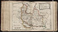
Hungary, Transilvania, &c
Description:
In pencil on verso: 23. and Table of contents for maps 20-24 misnumbered.
Subject (Geographic):
Hungary --Maps --Early works to 1800 and Transylvania (Romania) --Maps --Early works to 1800
Subject (Name):
Barker, B. (Benjamin), d. 1764, bookseller, Clements, Henry, d. 1719, bookseller, King, Charles, d. 1735, bookseller, Nicholson, John, d. ca. 1717, bookseller, Parker, Richard, fl. 1692-1725, bookseller, and Tooke, Benjamin, d. 1716, bookseller
Subject (Topic):
Atlases --Early works to 1800
Collection Created:
[London] : Sold by J. Nicholson at the King’s-Arms in Little Britain, Benj. Barker and Charles King ..., Benj. Tooke ..., Hen. Clements ..., R. Parker and Ralph Smith under the Royal-Exchange ..., [1715?]
Twenty four new and accurate maps of the several parts of Europe ... : all (except the last) new
Image Count:
1
Alternative Title:
Turkey in Europe
Description:
In pencil on verso: 24. and Table of contents for maps 20-24 misnumbered.
Subject (Geographic):
Turkey --Maps
Subject (Name):
Barker, B. (Benjamin), d. 1764, bookseller, Clements, Henry, d. 1719, bookseller, King, Charles, d. 1735, bookseller, Nicholson, John, d. ca. 1717, bookseller, Parker, Richard, fl. 1692-1725, bookseller, and Tooke, Benjamin, d. 1716, bookseller
Subject (Topic):
Atlases --Early works to 1800
Collection Created:
[London] : Sold by J. Nicholson at the King’s-Arms in Little Britain, Benj. Barker and Charles King ..., Benj. Tooke ..., Hen. Clements ..., R. Parker and Ralph Smith under the Royal-Exchange ..., [1715?]
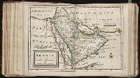
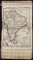
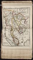
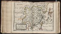
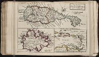
Forty-two new maps of Asia, Africa, and America ... : all engrav’d, according to the latest
Image Count:
1
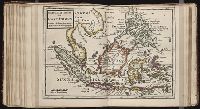
Alternative Title:
Japan, Niphon, &c, New Guinea, New Britain, and New Holland &c, and New Guinea,&c. This is joyn'd to Japan, Niphon, &c. being two maps in one plate
Description:
In ink on verso: 12.
Subject (Geographic):
Australia --Maps --Early works to 1800, Japan --Maps --Early works to 1800, New Britain Island (Papua New Guinea) --Maps, and New Guinea --Maps --To 1800
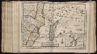
Forty-two new maps of Asia, Africa, and America ... : all engrav’d, according to the latest
Image Count:
1
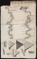
Alternative Title:
The River Nile, with all the pyramids
Description:
Imperfect: tear at bottom center fold with no loss of text., In ink on verso: 15., and Includes "The draught of ye pyramids taken exactly from Mr. Greaves".
Subject (Geographic):
Africa --Maps --Early works to 1800 and Nile River
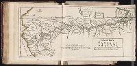
Forty-two new maps of Asia, Africa, and America ... : all engrav’d, according to the latest
Image Count:
1
Alternative Title:
Chili, Patagonia, part of La Plata &c
Description:
In pencil on verso: 27. and Table of contents for maps 2-20 in section "America" misnumbered.
Subject (Geographic):
Chile --Maps --Early works to 1800, Patagonia (Argentina and Chile) --Maps --Early works to 1800, South America --Maps --Early works to 1800, and Tierra del Fuego (Argentina and Chile)
Forty-two new maps of Asia, Africa, and America ... : all engrav’d, according to the latest
Image Count:
1
Alternative Title:
Peru, and the country of the Amazons
Description:
In pencil on verso: 28. and Table of contents for maps 2-20 in section "America" misnumbered.
Subject (Geographic):
Amazon River Region --Maps --Early works to 1800, La Plata (Argentina) --Maps, Peru --Maps --Early works to 1800, and South America --Maps --Early works to 1800
Forty-two new maps of Asia, Africa, and America ... : all engrav’d, according to the latest
Image Count:
1
Alternative Title:
A chart of the coasts of Peru, &c
Description:
In pencil on verso: 29. and Table of contents for maps 2-20 in section "America" misnumbered.
Subject (Geographic):
Darien (Panama and Colombia) --Early works to 1800, Peru --Maps --Early works to 1800, Popayan (Colombia), Quito (Ecuador) --Maps, and South America --Maps --Early works to 1800
Forty-two new maps of Asia, Africa, and America ... : all engrav’d, according to the latest
Image Count:
1
Alternative Title:
The great river Mazanon, or of the Amazons
Description:
In pencil on verso: 31., Right edge of map curled., and Table of contents for maps 2-20 in section "America" misnumbered.
Subject (Geographic):
Amazon River --Maps, Amazon River Region --Maps, Amazon River Valley --Maps, Colombia --Maps --Early works to 1800, Ecuador --Maps --Early works to 1800, and Venezuela --Maps
Forty-two new maps of Asia, Africa, and America ... : all engrav’d, according to the latest
Image Count:
1
Alternative Title:
Mexico, or New Spain
Description:
In pencil on verso: 33. and Table of contents for maps 2-20 in section "America" misnumbered.
Subject (Geographic):
California --Maps --Early works to 1800, Central America --Maps --Early works to 1800, Florida --Maps --Early works to 1800, Louisiana --Maps --Early works to 1800, Mexico --Maps --Early works to 1800, and New Mexico --Maps
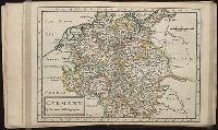
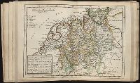
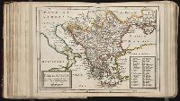
Twenty four new and accurate maps of the several parts of Europe ... : all (except the last) new
Image Count:
1
Alternative Title:
The south-west part of Germany, viz. Mentz and Treeves, Palatine of the Rhine, circles of Franconia, Swabia and Alsace, Lorain the Weteraw, &c
Description:
In pencil on verso: 11.
Subject (Geographic):
Alsace (France) --Maps, Franconia (Germany) --Maps, Germany --Maps --Early works to 1800, Lorraine (France) --Maps, Mainz (Rhineland-Palatinate, Germany) --Maps, Rhineland-Palatinate (Germany) --Maps, Swabia (Germany) --Maps --Early works to 1800, and Trier (Germany) --Maps
Subject (Name):
Barker, B. (Benjamin), d. 1764, bookseller, Clements, Henry, d. 1719, bookseller, King, Charles, d. 1735, bookseller, Nicholson, John, d. ca. 1717, bookseller, Parker, Richard, fl. 1692-1725, bookseller, and Tooke, Benjamin, d. 1716, bookseller
Subject (Topic):
Atlases --Early works to 1800
Collection Created:
[London] : Sold by J. Nicholson at the King’s-Arms in Little Britain, Benj. Barker and Charles King ..., Benj. Tooke ..., Hen. Clements ..., R. Parker and Ralph Smith under the Royal-Exchange ..., [1715?]