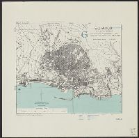
Geographical Section, General Staff ; 4379, GSGS (Series) ; 4379., and Sciacca
Description:
"6-43.", "From uncorrected air photographs of 1943. Fathom lines from Italian chart 173 of 1935.", "War Office, 1943.", Military grid (blue)., and Relief shown by rock drawings. Depths shown by isolines.
Publisher:
Army Map Service, U.S. Army,
Subject (Geographic):
Sciacca (Italy)--Maps
Subject (Name):
Great Britain. War Office. General Staff. Geographical Section and United States. Army Map Service
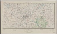
"Work Projects Administration project. Prepared under the direction of the Chief of Engineers, U.S. Army, by Engineer Reproduction Plant, the Army War College.", Coverage includes portions of Minnesota and Wisconsin., and Shows up to 7 classes of roads, 3 classes of railroads, and 4 classes of airfields.
Publisher:
Army Map Service,
Subject (Geographic):
Minnesota--Maps and Wisconsin--Maps
Subject (Name):
United States. Army Map Service and United States. Work Projects Administration
Subject (Topic):
Transportation--Minnesota--Maps and Transportation--Wisconsin--Maps
Great Britain. Army. Royal Engineers. Field Survey Coy., 19th
Published / Created:
1943
Call Number:
408 T15 1943
Container / Volume:
BRBL_00239
Image Count:
1
Resource Type:
Maps, Atlases & Globes
Alternative Title:
Great Britain. Army. Middle East Forces. M.D.R ; 539., GSGS (Series) ; 4379., Provisional GSGS (Middle East) ; 4379, and Sicily 1:2,500
Description:
"8-43.", "M.D.R. 539/8555.", "Printed by 514 C. Fd. Survey Coy. R.E., June, 43.", Important streets and points of interest are named., Military grid., and Relief shown by contours, hachures, land form drawings, and spot heights.
Great Britain. War Office. General Staff. Geographical Section
Published / Created:
1943
Call Number:
408 Ag84 1943
Container / Volume:
BRBL_00239
Image Count:
1
Resource Type:
Maps, Atlases & Globes
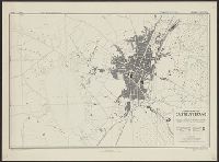
Alternative Title:
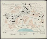
Geographical Section, General Staff ; no. 4379, GSGS (Series) ; 4379., and Italy 1:5,000
Description:
"5-43.", "Enlarged, "Published by the War Office, 1942, 2nd edition, 1943.", A few important streets are named., Also shows power lines, railways, and aquaducts., Includes index to buildings., Military grid., and Relief shown by contours, hachures, and spot heights.
Great Britain. War Office. General Staff. Geographical Section
Published / Created:
1943
Call Number:
40 Ao75 1943
Container / Volume:
BRBL_00204
Image Count:
1
Resource Type:
Maps, Atlases & Globes
Alternative Title:
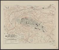
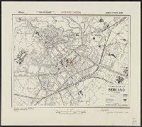
Geographical Section, General Staff ; no. 4380, GSGS (Series) ; 4380., and Italy
Description:
"12/42/G.S.G.S.", "2-43.", "Authorities, carta d'Italia 1:25,000 1930 ... various guide book plans.", "Published by War Office, 1942.", Important streets and buildings are named., Military grid., and Relief shown by form lines, hachures, and spot heights.
Great Britain. War Office. General Staff. Geographical Section
Published / Created:
1943
Call Number:
40 B45 1943
Container / Volume:
BRBL_00205
Image Count:
1
Resource Type:
Maps, Atlases & Globes
Alternative Title:
Geographical Section, General Staff ; no. 4380, GSGS (Series) ; 4380., and Italy
Description:
"12/42/G.S.G.S.", "2-43.", "Authorities ... Carta d'Italia 1:25,000, 1931. Various guide book plans.", "Published by War Office 1942.", Important streets and buildings are named., and Military grid.
Great Britain. War Office. General Staff. Geographical Section
Published / Created:
1943
Call Number:
408 C27 1943
Container / Volume:
BRBL_00239
Image Count:
1
Resource Type:
Maps, Atlases & Globes
Alternative Title:
Geographical Section, General Staff ; no. 4379, GSGS (Series) ; 4379., Sicily 1:5,000, and Sicily 1:5,000, town plan of Castelvetrano
Description:
"6-43.", "Air photographs have been used in the production of this plan.", "Authorities: Italy 1:100,000, G.S.G.S., no.4164, 1942; Italy 1:50,000, G.S.G.S., no.4229, 1941; intelligence information, 1943, "Published by War Office, 1943.", and Military grid (blue).
Great Britain. War Office. General Staff. Geographical Section
Published / Created:
1943. and Army Map Service, U. S. Army,
Call Number:
675 C33 1943
Container / Volume:
BRBL_00349
Image Count:
1
Resource Type:
Maps, Atlases & Globes
Alternative Title:
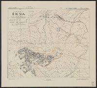
Geographical Section, General Staff ; no. 4241 and GSGS (Series) ; 4241.
Description:
"Contours at 10 metres interval.", "Published by War office, 1942. Revised by A. M. S. December, 1942.", Important streets and buildings are named., In upper margin: Morocco ..., and Military grid.
Great Britain. War Office. General Staff. Geographical Section
Published / Created:
1943
Call Number:
408 En61 1943
Container / Volume:
BRBL_00239
Image Count:
1
Resource Type:
Maps, Atlases & Globes
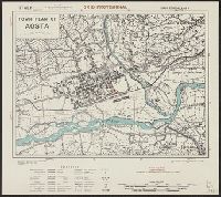
Alternative Title:
Geographical Section, General Staff ; no. 4379, GSGS (Series) ; 4379., Sicily 1:7,500, and Sicily 1:75,000, town plan of Enna
Description:
"6-43.", "Air photographs have been used in the production of this plan.", "Authorities: Italy 1:25,000 G.S.G.S. no. 4228, "Published by War Office 1943.", Relief shown by contours, hachures, and rock drawings., and Some streets and important buildings are named.