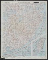
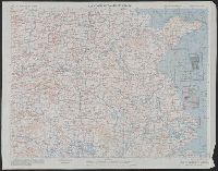
Shows roads, boundaries, railroads, power transmission lines, cities, towns, rivers, swamps, reefs and shoals.
Alternative Title:
AAF cloth map. and Asiatic series
Description:
"Officers using this chart will mark hereon corrections and addition, Aviator's survival map, printed on cloth., No. 34. Southeast China -- no. 35. Northeast China., Relief shown by hachures and spot heights (China)., and Shows wind directions and ocean currents.
Publisher:
Army Map Service, U.S. Army,
Subject (Geographic):
China, Southeast--Maps and Southeast Asia--Maps
Subject (Name):
United States. Aeronautical Chart Service and United States. Army Air Forces
Subject (Topic):
Military maps, Ocean currents--China--Maps, and Winds--China--Maps
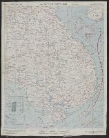
Shows roads, boundaries, railroads, power transmission lines, cities, towns, rivers, swamps, reefs and shoals.
Alternative Title:
AAF cloth map. and Asiatic series
Description:
"Officers using this chart will mark hereon corrections and additions which come to their attention and mail dire, No. 34. Southeast China -- no. 35. Northeast China., Originally issued as a restricted map., and Relief shown by hachures and spot heights (China).
Publisher:
Army Map Service, U.S. Army,
Subject (Geographic):
China, Southeast--Maps and Southeast Asia--Maps
Subject (Name):
United States. Aeronautical Chart Service and United States. Army Air Forces
Subject (Topic):
Military maps, Ocean currents--China--Maps, and Winds--China--Maps
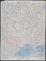
Shows roads, boundaries, railroads, power transmission lines, cities, towns, rivers, swamps, reefs and shoals.
Alternative Title:
AAF cloth map. and Asiatic series
Description:
"Officers using this chart will mark hereon corrections and additions which come to their attention and mail direct to 'Aeronautical Chart Service, Headquarters Army Air Forces, Washington, D.C.'"--Lower and Relief shown by hachures and spot heights (China).
Publisher:
Army Map Service, U.S. Army,
Subject (Geographic):
China, Southeast--Maps and Southeast Asia--Maps
Subject (Name):
United States. Aeronautical Chart Service and United States. Army Air Forces
Subject (Topic):
Military maps, Ocean currents--China--Maps, and Winds--China--Maps
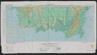
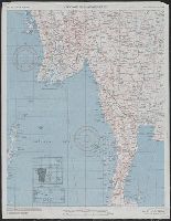
Shows roads, boundaries, railroads, power transmission lines, cities, towns, rivers, marsh, open water areas.
Alternative Title:
AAF cloth map. and Asiatic series
Description:
"Officers using this chart will mark her, Materials and list of maps in series from "US cloth maps of World War II" website., Originally issued as a restricted map., Relief shown by hachures and spot heights (China)., and Shows wind directions and ocean currents.
Publisher:
Army Map Service, U.S. Army,
Subject (Geographic):
China--Maps and Southeast Asia--Maps
Subject (Name):
United States. Aeronautical Chart Service and United States. Army Air Forces
Subject (Topic):
Military maps, Ocean currents--China--Maps, Ocean Currents--Southeast Asia--Maps, Winds--China--Maps, and Winds--Southeast Asia--Maps
Shows roads, boundaries, railroads, power transmission lines, cities, towns, rivers, marsh, open water areas.
Alternative Title:
AAF cloth map. and Asiatic series
Description:
"Officers using this chart will mark hereon corrections and additions which come t, Materials and list of maps in series from "US cloth maps of World War II" website., Originally issued as a restricted map., and Relief shown by hachures and spot heights (China).
Publisher:
Army Map Service, U.S. Army,
Subject (Geographic):
China--Maps and Southeast Asia--Maps
Subject (Name):
United States. Aeronautical Chart Service and United States. Army Air Forces
Subject (Topic):
Military maps, Ocean currents--China--Maps, Ocean Currents--Southeast Asia--Maps, Winds--China--Maps, and Winds--Southeast Asia--Maps
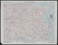
Shows roads, boundaries, railroads, power transmission lines, cities, towns, rivers, marsh, open water areas.
Alternative Title:
AAF cloth map. and Asiatic series
Description:
"Officers using this chart will mark hereon corrections and additions which come to their attention and mail direct to 'Aeronautical Chart Service, Headquarters Army Air Forces, Washington, D.C.'"--Lower left margin of each sheet. and Aviator's survival map,
Publisher:
Army Map Service, U.S. Army,
Subject (Geographic):
Burma--Maps
Subject (Name):
United States. Aeronautical Chart Service and United States. Army Air Forces
National Geographic Society (U.S.). Cartographic Section
Published / Created:
c1943.
Call Number:
60 1943
Container / Volume:
BRBL_00329
Image Count:
1
Resource Type:
Maps, Atlases & Globes
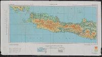
Description:
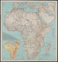
"International boundaries as of Sept. 1, 1939.", Includes a chart of airline distances., Inset: Relief. Scale 562 miles to 1 inch., Issued with the National Geographic magazine, v. 83, no. 2, February 1943., and Relief shown by hachures and spot heights.
National Geographic Society (U.S.). Cartographic Section
Published / Created:
c1943.
Call Number:
60 1943
Container / Volume:
BRBL_00329
Image Count:
1
Resource Type:
Maps, Atlases & Globes
Description:
"International boundaries as of Sept. 1, 1939.", Includes a chart of airline distances., Inset: Relief. Scale 562 miles to 1 inch., Issued with the National Geographic magazine, v. 83, no. 2, February 1943., and Relief shown by hachures and spot heights.