"Met prevelegie voor 15 jaer.", Appears in the van Keulen's De groote nieuwe vermeerderde zee-atlas ofte water-waereld., Copy 2: Not hand colored., Depths shown by soundings., In bottom right: 8., Includes ornamental cartouche,, and Oriented with north to the left.
Publisher:
Joannes van Keulen ... aende Nieuwebrugh inde gekroonde Lootsman,
Subject (Name):
Keulen, Johannes van, 1654-1715. Groote nieuwe vermeerderde zee-atlas ofte water-waereld
Subject (Topic):
Coasts--Angola--Maps--Early works to 1800 and Nautical charts--Angola--Early works to 1800
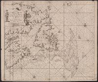
"22" in lower left and lower right corners., Appears in Keulen's De groote nieuwe vermeerderde zee-atlas ofte water-waereld., Ms., Shoal added around Accadie., and Shows Gulf of St. Lawrence from Newfoundland to the Gaspé, soundings indicated on the Grand Banks.
Publisher:
By Johannes van Keulen ...,
Subject (Geographic):
Atlantic Provinces--Maps--Early works to 1800 and Saint Lawrence, Gulf of--Maps--Early works to 1800
Subject (Name):
Keulen, Johannes van, 1654-1715. Groote nieuwe vermeerderde zee-atlas ofte water-waereld
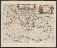
A sea chart with a variety of measuring scales and rumb lines., Appeared in Robijn's Zeeatlas (1683); see Koeman, C. Atlantes Neerlandici, IV, p. 438 (Rob 1, map 18)., and Imperfect: mutilated, with some loss of cartouche. Backed with linen. Cross Collection 62.
Publisher:
By Jacobus Robyn,
Subject (Geographic):
Atlantic Ocean--Maps--Early works to 1800, Brazil--Maps--Early works to 1800, Cape Verde--Maps--Early works to 1800, and New Guinea--Maps--Early works to 1800
Subject (Name):
Robijn, Jacobus, -approximately 1710. Zeeatlas
Subject (Topic):
Nautical charts--Atlantic Ocean--Early works to 1800
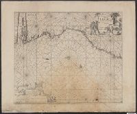
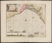
Appears in the author's De groote nieuwe vermeerderde zee-atlas ofte water-waereld. 1709., Depths shown by soundings., In bottom right: 9., Includes inset of "Aldus verthoont Agoa de Saldanha," ornamental cartouche, rhumb lines, and ill., and Oriented with north
Publisher:
Joannes van Keulen ... aende Nieuwebrug in gekroonde Lootsman,
Subject (Name):
Keulen, Johannes van, 1654-1715. Groote nieuwe vermeerderde zee-atlas ofte water-waereld
Subject (Topic):
Coasts--Angola--Maps--Early works to 1800, Coasts--Namibia--Maps--Early works to 1800, Coasts--South Africa--Cape of Good Hope--Maps--Early works to 1800, and Nautical charts--Atlantic coast (Africa)--Early works to 1800
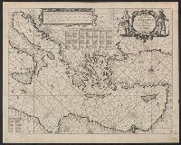
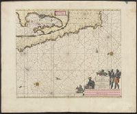
"Met prevelegie voor 15 jaer.", Appears in the author's De groote nieuwe vermeerderde zee-atlas ofte water-waereld. 1709., Depths shown by soundings., In bottom right: 5., and Includes coastal profile, ornamental cartouche, rhumb lines, and ill.
Publisher:
Joannes van Keulen ... aende Nieuwe brug inde gecroonde Lootsman,
Subject (Name):
Keulen, Johannes van, 1654-1715. Groote nieuwe vermeerderde zee-atlas ofte water-waereld
Subject (Topic):
Coasts--Benin--Maps--Early works to 1800, Coasts--Nigeria--Maps--Early works to 1800, and Nautical charts--Benin, Bight of--Early works to 1800
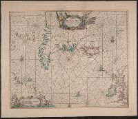
Appears in the author's Zee-atlas ofte water-waereld. [Amsterdam : Pieter Goos], 1666., Burden's state 2, but without imprint. Cross collection no. 57., Includes ill. and rhumb lines., and Relief shown pictorially.
Publisher:
Pieter Goos,
Subject (Geographic):
North Atlantic Ocean--Maps--Early works to 1800
Subject (Name):
Goos, Pieter, approximately 1616-1675. Zee-atlas ofte water-waereld
Subject (Topic):
Nautical charts--North Atlantic Ocean--Early works to 1800