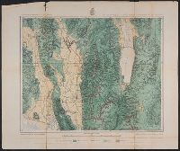
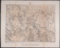
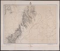
Geographical Surveys West of the 100th Meridian (U.S.)
Published / Created:
[1878]
Call Number:
832 1878
Container / Volume:
BRBL_00582
Image Count:
1
Resource Type:
Maps, Atlases & Globes
Description:
"Expedition of 1877 under the command of 1st Lieut. Geo. M. Wheeler, Corps of Engineers, U.S. Army.", "Issued June 30, 1878.", "Weyss, Lang, & Herman, Del.", From United States Army Corps of Engineers' Topographical, and Relief shown by hachures and spot heights.
Publisher:
[U.S. Geographical Surveys West of the 100th Meridian],
Subject (Geographic):
Idaho--Maps
Subject (Name):
United States. Army. Corps of Engineers. Topographical atlas projected to illustrate explorations and surveys west of the 100th meridian of longitude and Wheeler, George M. (George Montague), 1842-1905
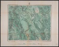
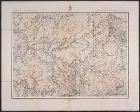
Geographical Surveys West of the 100th Meridian (U.S.)
Published / Created:
[1879]
Call Number:
832 1879A
Container / Volume:
BRBL_00582
Image Count:
1
Resource Type:
Maps, Atlases & Globes
Description:
From United States Army Corps of Engineers' Topographical atlas projected to illustrate explorations and surveys west of the 100th meridian of longitude., Prime meridians: Washington and Greenwich., and Shows areas classed as agricultural, timber, grazing, and arid or barren.
Publisher:
[U.S. Geographical Surveys West of the 100th Meridian],
Subject (Geographic):
Idaho--Maps
Subject (Name):
United States. Army. Corps of Engineers. Topographical atlas projected to illustrate explorations and surveys west of the 100th meridian of longitude and Wheeler, George M. (George Montague), 1842-1905
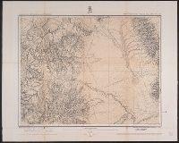
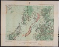
Geographical Surveys West of the 100th Meridian (U.S.)
Published / Created:
1879
Call Number:
834 1879B
Container / Volume:
BRBL_00587
Image Count:
1
Resource Type:
Maps, Atlases & Globes
Description:
"By Order of the Honorable The Secretary of War. Under the, "Expeditions of 1873, '74, '75 & '76 under the command of 1st. Lieut. Geo. M. Wheeler, Corps of Engineers, U.S. Army.", On verso: 4., and Shows geographical features, roads, settlements, and distances.
Publisher:
U.S. Geographical Surveys West of the 100th Meridian,
Subject (Geographic):
Colorado--Surveys--Maps
Subject (Name):
United States. Army. Corps of Engineers, Weyss, Lang & Herman, Del, Wheeler, George M. (George Montague), 1842-1905, and Wright, Horatio Gouverneur, 1820-1899
Subject (Topic):
Land capability for agriculture--Colorado--Maps and Land use--Colorado--Maps
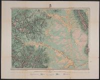
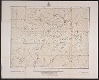
Geographical Surveys West of the 100th Meridian (U.S.)
Published / Created:
[1878]
Call Number:
834 1878
Container / Volume:
BRBL_00587
Image Count:
1
Resource Type:
Maps, Atlases & Globes
Description:
"Atlas sheet no. 61(D).", "Expeditions of 1873, 74, 75 & 76 under the command of 1st. Lieut. Geo. M. Wheeler, Corps of Engineers, U.S. Army.", "Issued Jan. 10th 1878.", "Weyss, Lang & Herman, del.", and Relief shown by hachures and spot heights.
Publisher:
[U.S. Geographical Surveys West of the 100th Meridian],
Geographical Surveys West of the 100th Meridian (U.S.)
Published / Created:
1876
Call Number:
842 1876A
Container / Volume:
BRBL_00598
Image Count:
1
Resource Type:
Maps, Atlases & Globes
Description:
"5"--Verso., "Expeditions of 1871-1872 & 1873 under the comman, "Weyss, Herman & Lang, del."--Margin., Relief shown by hachures and spot heights., and Sheet no. 75 from Wheeler's Geographical exploration and surveys west of the 100th meridian topographical atlas.
Geographical Surveys West of the 100th Meridian (U.S.)
Published / Created:
[1876]
Call Number:
842 1876C
Container / Volume:
BRBL_00598
Image Count:
1
Resource Type:
Maps, Atlases & Globes
Description:
"Atlas sheet no. 83.", "Expeditions of 1871 & 1873 under the command of 1st. Lieut. Geo. M. Wheeler, Corps of Engineers, U.S. Army.", "Issued Mar. 18th 1876.", "Weyss, Herman & Lang, del.", and Relief shown by hachures and spot heights.
Publisher:
[U.S. Geographical Surveys West of the 100th Meridian],
Subject (Geographic):
Arizona--Surveys--Maps and New Mexico--Surveys--Maps
Geographical Surveys West of the 100th Meridian (U.S.)
Published / Created:
[approximately 1876]
Call Number:
834 1876C
Container / Volume:
BRBL_00587
Image Count:
1
Resource Type:
Maps, Atlases & Globes
Description:
"Atlas sheet no. 61(C).", "Expeditions of 1874-1875 under the command of 1st. Lieut. Geo. M. Wheeler, Corps of Engineers, U.S. Army.", "J.C. Spiller, del.", and Relief shown by hachures and spot heights.
Publisher:
[U.S. Geographical Surveys West of the 100th Meridian],
Geographical Surveys West of the 100th Meridian (U.S.)
Published / Created:
1879
Call Number:
841 1879A
Container / Volume:
BRBL_00596
Image Count:
1
Resource Type:
Maps, Atlases & Globes
Alternative Title:
Land classification map of part of southern New Mexico, atlas sheet no. 84 (B)
Description:
"7"--Verso., "Expeditions of 1877.", "Issued June 30, 1879.", "Weyss, Lang and Herman, del."--Lower right border., Includes atla, Relief shown by hachures and spot heights., and Shows land types: agricultural (with irrigation), timber, grazing, and arid and barren.
Geographical Surveys West of the 100th Meridian (U.S.)
Published / Created:
[1878]
Call Number:
841 1878B
Container / Volume:
BRBL_00596
Image Count:
1
Resource Type:
Maps, Atlases & Globes
Alternative Title:
Part of southern New Mexico, atlas sheet no. 84 (B)
Description:
"10"--Verso., "Weyss, Lang and Herman, del."-, Differs from 1879 map of identical title in that eastern relief missing on this map and type/text size smaller around margins., and Relief shown by hachures and spot heights. Relief not shown on eastern half of map.