Search
You Searched For
Search Results
- Published / Created:
- [1756?]
- Call Number:
- 755 1756C
- Container / Volume:
- BRBL_00428
- Image Count:
- 1
- Resource Type:
- Maps, Atlases & Globes
- Subject (Geographic):
- North America--Maps--Early works to
- Subject (Topic):
- British--North America--Maps--Early
- Found in:
- Beinecke Rare Book and Manuscript Library > The British & French dominions in North America : particularly shewing the French encroachments through all the British plantations from Nova Scotia down to the Gulf of Mexico.
- Creator:
- Lodge, John, -1796
- Published / Created:
- [1778?]
- Call Number:
- BrSides 2017 62
- Image Count:
- 1
- Resource Type:
- Maps, Atlases & Globes
- Subject (Geographic):
- North America--Maps--Early works to
- Found in:
- Beinecke Rare Book and Manuscript Library > A general map of North America ; from the latest observations / engrav'd by Jno. Lodge from the late Mr. Jefferys, geographer to the King.
- Creator:
- Delarochette, L. (Louis), 1731-1802
- Published / Created:
- 1st of March 1789.
- Call Number:
- 71 1789
- Container / Volume:
- BRBL_00366
- Image Count:
- 4
- Resource Type:
- Maps, Atlases & Globes
- Subject (Geographic):
- North America--Maps--Early works to
- Found in:
- Beinecke Rare Book and Manuscript Library > A map of North America and the West Indies / by L.S. de la Rochette.
- Creator:
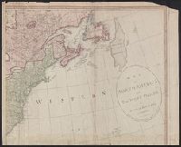
- Herbert, William, 1718-1795
- Published / Created:
- 1755
- Call Number:
- 755 1755W
- Container / Volume:
- BRBL_00427
- Image Count:
- 1
- Resource Type:
- Maps, Atlases & Globes
- Subject (Geographic):
- North America--Maps--Early works to
- Found in:
- Beinecke Rare Book and Manuscript Library > A new and accurate map of the English empire in North America : representing their rightful claim as confirm'd by charters, and the formal surrender of their Indian friends; likewise the encroachments of the French, with the several forts they have unjust
- Creator:
- Pownall, Thomas, 1722-1805
- Published / Created:
- 1786
- Call Number:
- 71 1783
- Container / Volume:
- BRBL_00366
- Image Count:
- 2
- Resource Type:
- Maps, Atlases & Globes
- Subject (Geographic):
- North America--Maps--Early works to
- Found in:
- Beinecke Rare Book and Manuscript Library > A new map of North America, with the West India Islands : divided according to the preliminary articles of peace, signed at Versailles, 20, Jan. 1783. Wherein are particularly distinguished the United States and the several provinces, governments &ca. whi
- Creator:
- Kitchin, Thomas, d. 1784
- Published / Created:
- [1782]
- Call Number:
- 755 1760A
- Container / Volume:
- BRBL_00428
- Image Count:
- 1
- Resource Type:
- Maps, Atlases & Globes
- Subject (Geographic):
- North America--Maps--Early works to
- Found in:
- Beinecke Rare Book and Manuscript Library > A new map of the British Empire in Nth. America / drawn from the latest authorities by Thos. Kitchin, geor., hydrographer to His Majesty.
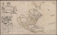
- Creator:
- Moll, Herman, -1732
- Published / Created:
- 1720
- Call Number:
- 71 1720C
- Container / Volume:
- BRBL_00687
- Image Count:
- 1
- Resource Type:
- Maps, Atlases & Globes
- Subject (Geographic):
- North America--Maps--Early works to
- Found in:
- Beinecke Rare Book and Manuscript Library > A new map of the north parts of America claimed by France under ye names of Louisiana, Mississipi, Canada and New France with ye adjoyning territories of England and Spain ... : the projection of this map is call'd Mercator's, and it is laid down accordin
- Creator:
- Moll, Herman, -1732
- Published / Created:
- 1720
- Call Number:
- 71 1720C
- Container / Volume:
- BRBL_00361
- Image Count:
- 1
- Resource Type:
- Maps, Atlases & Globes
- Subject (Geographic):
- North America--Maps--Early works to
- Found in:
- Beinecke Rare Book and Manuscript Library > A new map of the north parts of America claimed by France under ye names of Louisiana, Mississipi, Canada and New France with ye adjoyning territories of England and Spain ... : the projection of this map is call'd Mercator's, and it is laid down accordin
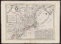
- Published / Created:
- [1736?]
- Call Number:
- 755 1736
- Container / Volume:
- BRBL_00728
- Image Count:
- 1
- Resource Type:
- Maps, Atlases & Globes
- Subject (Geographic):
- North America--Maps--Early works to
- Found in:
- Beinecke Rare Book and Manuscript Library > New England, New York, New Jersey and Pensylvania.
- Creator:
- Senex, John, -1740
- Published / Created:
- [between 1750 and 1769?]
- Call Number:
- 71 1755B
- Container / Volume:
- BRBL_00363
- Image Count:
- 1
- Resource Type:
- Maps, Atlases & Globes
- Subject (Geographic):
- North America--Maps--Early works to
- Found in:
- Beinecke Rare Book and Manuscript Library > North America : corrected from the observations communicated to the Royal Society at London and the Royal Academy at Paris / by John Senex F.R.S., 1710.
- Creator:
- Kitchin, Thomas, d. 1784
- Published / Created:
- Sepr. 29th 1787.
- Call Number:
- 71 1787D
- Container / Volume:
- BRBL_00366
- Image Count:
- 1
- Resource Type:
- Maps, Atlases & Globes
- Alternative Title:
- Map of North America (1787)
- Description:
- . with label titled "Map of North America
- Subject (Geographic):
- North America--Maps--Early works to
- Found in:
- Beinecke Rare Book and Manuscript Library > North America drawn from the latest and best authorities / T. Kitchin, del. ; engrav'd by G. Terry.
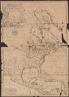
- Creator:
- Moll, Herman, d. 1732
- Published / Created:
- [1720]
- Call Number:
- 71 1720D
- Container / Volume:
- BRBL_00361
- Image Count:
- 1
- Resource Type:
- Maps, Atlases & Globes
- Subject (Geographic):
- North America--Maps--Early works to
- Found in:
- Beinecke Rare Book and Manuscript Library > To the right honourable John Lord Sommers, Baron of Evesham in ye county of Worcester, president of Her Majesty's most honourable Privy Council &c., this map of North America, according to ye newest and most exact observations is most humbly dedicated by
- Creator:
- Gibson, J. (John)
- Published / Created:
- 1758
- Call Number:
- 755 1758
- Container / Volume:
- BRBL_00428
- Image Count:
- 1
- Resource Type:
- Maps, Atlases & Globes
- Subject (Geographic):
- North America--Maps--Early works to
- Found in:
- Beinecke Rare Book and Manuscript Library > A general map of the middle British colonies in America : viz. Virginia, Maryland, Delaware, Pensilvania, New-Jersey, New-York, Connecticut and Rhode-Island : of Aquanishuonigy the country of the confederate Indians comprehending Aquanishuonigy proper, th
- Creator:
- Bowen, Thomas, -1790
- Published / Created:
- 1755]
- Call Number:
- BrSides Folio 2019 104
- Image Count:
- 1
- Resource Type:
- Maps, Atlases & Globes
- Subject (Geographic):
- North America--Maps--Early works to
- Found in:
- Beinecke Rare Book and Manuscript Library > A map of the British and French settlements in North America / T. Bowen, sculpt.
- Creator:
- Jefferys, Thomas, d. 1771
- Published / Created:
- May 1755.
- Call Number:
- 755 1755B
- Container / Volume:
- BRBL_00427
- Image Count:
- 1
- Resource Type:
- Maps, Atlases & Globes
- Subject (Geographic):
- North America--Maps--Early works to
- Found in:
- Beinecke Rare Book and Manuscript Library > North America from the French of Mr. D'Anville : improved with the back settlements of Virginia and course of Ohio : illustrated with geographical and historical remarks.
- Creator:
- Berry, William, fl. 1669-1708
- Published / Created:
- 1680
- Call Number:
- 71 1680
- Container / Volume:
- BRBL_00360
- Image Count:
- 1
- Resource Type:
- Maps, Atlases & Globes
- Description:
- Ireland, this map of North America
- Subject (Geographic):
- North America--Maps--Early works to
- Found in:
- Beinecke Rare Book and Manuscript Library > North America divided into its principall parts where are distinguished the severall states which belong to the English, Spanish, and French / described by Sanson ; corrected and amended by William Berry.
- Creator:
- Moll, Herman, d. 1732
- Published / Created:
- 1715
- Call Number:
- 755 1715
- Container / Volume:
- BRBL_00425
- Image Count:
- 1
- Resource Type:
- Maps, Atlases & Globes
- Subject (Geographic):
- North America--Maps--Early works to
- Found in:
- Beinecke Rare Book and Manuscript Library > A new and exact map of the dominions of the King of Great Britain on ye continent of North America : containing Newfoundland, New Scotland, New England, New York, New Jersey, Pensilvania, Maryland, Virginia, and Carolina ... / by Herman Moll, geographer.
- Creator:
- Moll, Herman, d. 1732
- Published / Created:
- 1715 [i.e., 1726?]
- Call Number:
- 755 1715B
- Container / Volume:
- BRBL_00425
- Image Count:
- 1
- Resource Type:
- Maps, Atlases & Globes
- Subject (Geographic):
- North America--Maps--Ear
- Found in:
- Beinecke Rare Book and Manuscript Library > A new and exact map of the dominions of the King of Great Britain on ye continent of North America : containing Newfoundland, New Scotland, New England, New York, New Jersey, Pensilvania, Maryland, Virginia, and Carolina ... / by Herman Moll, geographer.