Search
You Searched For
Search Results
- Creator:
- Wyld, James, 1812-1887
- Published / Created:
- [1866?]
- Call Number:
- 35311 1866
- Container / Volume:
- BRBL_00112
- Image Count:
- 1
- Resource Type:
- Maps, Atlases & Globes
- Found in:
- Beinecke Rare Book and Manuscript Library > The Crimea / by James Wyld.
- Published / Created:
- 1809
- Call Number:
- 50 1809
- Container / Volume:
- BRBL_00272
- Image Count:
- 4
- Resource Type:
- Maps, Atlases & Globes
- Found in:
- Beinecke Rare Book and Manuscript Library > The Continent and Islands of Asia ... Delineated by Jno. Purdy, Engraved by Josph. Bye.
- Published / Created:
- 1809
- Call Number:
- 60 1809
- Container / Volume:
- BRBL_00325
- Image Count:
- 4
- Resource Type:
- Maps, Atlases & Globes
- Found in:
- Beinecke Rare Book and Manuscript Library > The Continent and Islands of Africa ... Delineated by John Purdy.
- Published / Created:
- 1682
- Call Number:
- BrSides By6 1682
- Image Count:
- 1
- Found in:
- Beinecke Rare Book and Manuscript Library > The Compleat swearing-master : a rare new Salamanca ballad : to the tune of, Now now the fight's done.
- Published / Created:
- Oct. 1783.
- Call Number:
- 906 1783
- Container / Volume:
- BRBL_00667
- Image Count:
- 2
- Resource Type:
- Maps, Atlases & Globes
- Found in:
- Beinecke Rare Book and Manuscript Library > The Coast of Guyana fron the Oroonoko to the River of Amazons and the Inland Parts, as far as they have been Explored by the French and Dutch Engineers with the Island of Barbadoes Tobago & co. From hte Observations of Capitain Edward Thompson, made in th
- Published / Created:
- 1682
- Call Number:
- BrSides By6 1682
- Image Count:
- 1
- Resource Type:
- Books, Journals & Pamphlets
- Found in:
- Beinecke Rare Book and Manuscript Library > The Cavaliers litany.
- Published / Created:
- 1793
- Call Number:
- 335 1793
- Container / Volume:
- BRBL_00086
- Image Count:
- 1
- Resource Type:
- Maps, Atlases & Globes
- Found in:
- Beinecke Rare Book and Manuscript Library > The Catholic Netherlands.
- Published / Created:
- [1720]
- Call Number:
- BrSides 2013 135
- Image Count:
- 2
- Found in:
- Beinecke Rare Book and Manuscript Library > The Bublers Mirrour: or England's Folley [graphic].
- Published / Created:
- [1720]
- Call Number:
- BrSides 2013 136
- Image Count:
- 2
- Found in:
- Beinecke Rare Book and Manuscript Library > The Bublers Mirrour, or, England's Folley [graphic].
- Creator:
- Wyld, James, 1812-1887
- Published / Created:
- March 2nd 1857.
- Call Number:
- 71 1857
- Container / Volume:
- BRBL_00371
- Image Count:
- 2
- Resource Type:
- Maps, Atlases & Globes
- Found in:
- Beinecke Rare Book and Manuscript Library > The British possessions in North America and the United States with the Hudson's Bay territories / by James Wyld, geographer to the Queen & H.R.H. Prince Albert.
- Published / Created:
- 1906
- Call Number:
- 319gme 1906
- Container / Volume:
- BRBL_00042
- Image Count:
- 1
- Resource Type:
- Maps, Atlases & Globes
- Found in:
- Beinecke Rare Book and Manuscript Library > The British Isles (Railway) showing main trunk lines and principal branches and connections.
- Published / Created:
- [1767?]
- Call Number:
- 755 1767
- Container / Volume:
- BRBL_00429
- Image Count:
- 1
- Resource Type:
- Maps, Atlases & Globes
- Found in:
- Beinecke Rare Book and Manuscript Library > The British & French Dominions in North America. Particularly showing the French Enroachments through all the British Plantations from Nova Scotia down to the Gulf of Mexico.
- Creator:
- Jefferys, Thomas, d. 1771
- Published / Created:
- 20, Feby. 1775.
- Call Number:
- 894 1775
- Container / Volume:
- BRBL_00697
- Image Count:
- 1
- Resource Type:
- Maps, Atlases & Globes
- Found in:
- Beinecke Rare Book and Manuscript Library > The Bay of Honduras [cartographic material] / by Thos. Jefferys, Geographer to His Majesty.
- Published / Created:
- [1850?]
- Call Number:
- 23 1850
- Container / Volume:
- BRBL_00020
- Image Count:
- 1
- Resource Type:
- Maps, Atlases & Globes
- Found in:
- Beinecke Rare Book and Manuscript Library > The Basin of the Pacific by Jas. Wyld.
- Creator:
- Defoe, Daniel, 1661?-1731
- Published / Created:
- [1710?]
- Call Number:
- Ik D362 710Be
- Image Count:
- 8
- Found in:
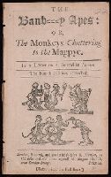
- Beinecke Rare Book and Manuscript Library > The Banb--y apes, or, The monkeys chattering to the magpye : in a letter to a friend in London
- Published / Created:
- 1787
- Call Number:
- 21 1787
- Container / Volume:
- BRBL_00724
- Image Count:
- 1
- Resource Type:
- Maps, Atlases & Globes
- Found in:
- Beinecke Rare Book and Manuscript Library > The Atlantic Ocean / by Governor Pownall F.R.S.
- Creator:
- Stokes, John Lort, 1811-1885, cartographer.
- Published / Created:
- April 10, 1845.
- Call Number:
- BrSides Double Folio 2019 108
- Image Count:
- 1
- Resource Type:
- Maps, Atlases & Globes
- Found in:
- Beinecke Rare Book and Manuscript Library > The Albert River : 1841 / surveyed by J.L. Stokes, R.N. ; J. & C. Walker, sculpt.
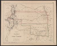
- Creator:
- Rogers, Henry D. (Henry Darwin), 1808-1866
- Published / Created:
- [1857?]
- Call Number:
- 824 1857B
- Container / Volume:
- BRBL_00570
- Image Count:
- 1
- Resource Type:
- Maps, Atlases & Globes
- Found in:
- Beinecke Rare Book and Manuscript Library > Territory of Nebraska / by H.D. Rogers & A. Keith Johnston ; engraved by W. & A.K. Johnston.
- Creator:
- Rogers, Henry D. (Henry Darwin), 1808-1866
- Published / Created:
- [1857?]
- Call Number:
- 825 1857A
- Container / Volume:
- BRBL_00573
- Image Count:
- 1
- Resource Type:
- Maps, Atlases & Globes
- Found in:
- Beinecke Rare Book and Manuscript Library > Territory of Kansas and Indian Territory / by H.D. Rogers & A. Keith Johnston ; engraved by W. & A.K. Johnston, Edinburgh.
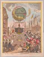
- Creator:
- Gillray, James, 1756-1815, printmaker.
- Published / Created:
- [8 August 1810]
- Call Number:
- Auchincloss Gillray v. 6
- Image Count:
- 1
- Found in:
- Beinecke Rare Book and Manuscript Library > Tentanda via est qua me quoque possim tollere humo. Virgil, Geor. [graphic] : He steers his flight aloft, incumbent on the dusky air that felt unusual weight. Par. Lost. Lib. I, l. 225 / J. Gillray, fect &c.
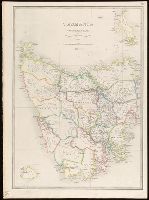
- Creator:
- Wyld, James, 1812-1887
- Published / Created:
- [1861?]
- Call Number:
- 266 1850
- Image Count:
- 1
- Resource Type:
- Maps, Atlases & Globes
- Found in:
- Beinecke Rare Book and Manuscript Library > Tasmania or Van Diemens Land [cartographic material] / by James Wyld Geographer to the Queen.
- Creator:
- Anville, Jean Baptiste Bourguignon d', 1697-1782
- Published / Created:
- 1821
- Call Number:
- 400 1821
- Container / Volume:
- BRBL_00233
- Image Count:
- 1
- Resource Type:
- Maps, Atlases & Globes
- Found in:
- Beinecke Rare Book and Manuscript Library > Tabula Italiae antiquae geographica : quam excellentissimus dominus Dux de la Rochefoucauld in aere incidi curavit / auctor d'Anville ... MDCCLXIV.
- Creator:
- Bacon, Francis, 1561-1626
Cecil, Thomas, fl. 1630, printmaker
Rawley, William, 1588?-1667
- Published / Created:
- 1651
- Call Number:
- Ih B132 +627h
- Image Count:
- 132
- Found in:
- Beinecke Rare Book and Manuscript Library > Sylva sylvarum, or, A naturall history : in ten centuries : whereunto is newly added The history naturall and experimentall of life and death, or, Of the prolongation of life / both written by the Right Honourable Francis lo. Verulam viscount St. Alban ; published after the author's death, by William Rawley ... Hereunto is now added an alphabeticall table of the principall things contained in the ten centureis.
- Published / Created:
- 1813
- Call Number:
- 3617 1813
- Image Count:
- 1
- Resource Type:
- Maps, Atlases & Globes
- Found in:
- Beinecke Rare Book and Manuscript Library > Swedish Pomerania with the Island of Rugen ... by F.W.C. Baron Schmettan ...
- Published / Created:
- 1745
- Call Number:
- 32 L84 1745
- Container / Volume:
- BRBL_00048
- Image Count:
- 2
- Resource Type:
- Maps, Atlases & Globes
- Found in:
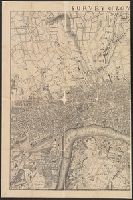
- Beinecke Rare Book and Manuscript Library > Survey of London made in the year 1745.
- Published / Created:
- [c1902]
- Call Number:
- 3212 1920
- Container / Volume:
- BRBL_00055
- Image Count:
- 1
- Resource Type:
- Maps, Atlases & Globes
- Found in:
- Beinecke Rare Book and Manuscript Library > Surrey.
- Creator:
- Edward Stanford Ltd
- Published / Created:
- [1916?]
- Call Number:
- 30ed 1916
- Container / Volume:
- BRBL_00037B
- Image Count:
- 1
- Resource Type:
- Maps, Atlases & Globes
- Found in:
- Beinecke Rare Book and Manuscript Library > Subject nationalities of the German alliance.
- Published / Created:
- [1917?]
- Call Number:
- 304ed 1916B
- Container / Volume:
- BRBL_00034A
- Image Count:
- 1
- Resource Type:
- Maps, Atlases & Globes
- Found in:
- Beinecke Rare Book and Manuscript Library > Subject nationalities of the German alliance : from the Allies' peace terms as stated in their reply to President Wilson's note of 19th Dec. 1916 : [Eurasia].
- Published / Created:
- [1917?]
- Call Number:
- 11hc 1916A
- Container / Volume:
- BRBL_00010C
- Image Count:
- 1
- Resource Type:
- Maps, Atlases & Globes
- Found in:
- Beinecke Rare Book and Manuscript Library > Subject nationalities of the German alliance : from the Allies' peace terms as stated in their reply to President Wilson's note of 19th Dec. 1916 : [Eurasia].
- Published / Created:
- 1801
- Call Number:
- 75 1801
- Container / Volume:
- BRBL_00727
- Image Count:
- 1
- Resource Type:
- Maps, Atlases & Globes
- Found in:
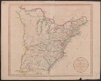
- Beinecke Rare Book and Manuscript Library > States of America, drawn from the best authorities / by. J: Russell.
- Creator:
- Rogers, Henry D. (Henry Darwin), 1808-1866
- Published / Created:
- [1857]
- Call Number:
- 796 1857C
- Container / Volume:
- BRBL_00525
- Image Count:
- 1
- Resource Type:
- Maps, Atlases & Globes
- Found in:
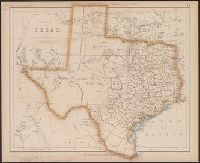
- Beinecke Rare Book and Manuscript Library > State of Texas / by Prof. H.D. Rogers & A. Keith Johnston, F.R.S.E. ; engraved by W. & A.K. Johnston.
- Creator:
- Edward Stanford Ltd
- Published / Created:
- 1913
- Call Number:
- 32 L84 1913A
- Container / Volume:
- BRBL_00051
- Image Count:
- 1
- Resource Type:
- Maps, Atlases & Globes
- Found in:
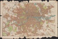
- Beinecke Rare Book and Manuscript Library > Stanford's new two inch map of London and its environs.
- Creator:
- Edward Stanford Ltd
- Published / Created:
- August 1st, 1901.
- Call Number:
- 642 1901A
- Container / Volume:
- BRBL_00339
- Image Count:
- 1
- Resource Type:
- Maps, Atlases & Globes
- Found in:
- Beinecke Rare Book and Manuscript Library > Stanford's new map of the Orange River Colony, the southern part of the Transvaal, the northern frontier of Cape Colony, Natal, Basutoland, and Delagoa Bay in Portuguese East Africa / Stanford's Geographical Establishment, London.
- Published / Created:
- 1861 May 13
- Call Number:
- 75 1861A
- Container / Volume:
- BRBL_00402
- Image Count:
- 1
- Resource Type:
- Maps, Atlases & Globes
- Found in:
- Beinecke Rare Book and Manuscript Library > Stanford's new hand map of the United States of North America / Constructed and engrd. at Stanford's Geographical Establishmt. London.
- Published / Created:
- May 2nd, 1870.
- Call Number:
- 75 1870C
- Container / Volume:
- BRBL_00404
- Image Count:
- 2
- Resource Type:
- Maps, Atlases & Globes
- Found in:
- Beinecke Rare Book and Manuscript Library > Stanford's map of the United States and part of the Dominion of Canada.
- Creator:
- Stanford, Edward, 1827-1904
- Published / Created:
- 1862
- Call Number:
- 32 L84 1862B
- Image Count:
- 2
- Resource Type:
- Maps, Atlases & Globes
- Found in:
- Beinecke Rare Book and Manuscript Library > Stanford's library map of London and its suburbs [cartographic material].
- Creator:
- Stanford, Edward, 1827-1904
- Published / Created:
- [1875?].
- Call Number:
- 75 1875B
- Container / Volume:
- BRBL_00405
- Image Count:
- 1
- Resource Type:
- Maps, Atlases & Globes
- Found in:
- Beinecke Rare Book and Manuscript Library > Stanford's handy map of the United States : distinguishing the unsettled territories; the railways; the cities & towns according to population; also the state capitals & county towns.
- Creator:
- Edward Stanford Ltd
- Published / Created:
- 1917
- Call Number:
- 11hc 1917S
- Container / Volume:
- BRBL_00010E
- Image Count:
- 1
- Resource Type:
- Maps, Atlases & Globes
- Found in:
- Beinecke Rare Book and Manuscript Library > Stanford's half-inch map of the battle front, Ostend, Zeebrugge, Bruges / Edward Stanford Ltd.
- Creator:
- Edward Stanford Ltd
- Published / Created:
- 1917
- Call Number:
- 11hc 1917P
- Container / Volume:
- BRBL_00010E
- Image Count:
- 1
- Resource Type:
- Maps, Atlases & Globes
- Found in:
- Beinecke Rare Book and Manuscript Library > Stanford's half-inch map of the British front in France & Flanders.
- Creator:
- Edward Stanford Ltd
- Published / Created:
- 1878
- Call Number:
- 44FD 1878A
- Container / Volume:
- BRBL_00257
- Image Count:
- 1
- Resource Type:
- Maps, Atlases & Globes
- Found in:
- Beinecke Rare Book and Manuscript Library > Stanford's "Treaty map" of south eastern Europe and Armenia [cartographic material].
- Creator:
- George Philip & Son
- Published / Created:
- [1920?]
- Call Number:
- 59 1920
- Container / Volume:
- BRBL_00317
- Image Count:
- 2
- Resource Type:
- Maps, Atlases & Globes
- Found in:
- Beinecke Rare Book and Manuscript Library > Specimen map from Philips' international atlas : Indian empire with Ceylon - general / London Geographical Institute.
- Published / Created:
- 1811
- Call Number:
- 88 1811A
- Container / Volume:
- BRBL_00644
- Image Count:
- 1
- Resource Type:
- Maps, Atlases & Globes
- Found in:
- Beinecke Rare Book and Manuscript Library > Spanish dominions in North America : northern part / drawn under the direction of Mr. Pinkerton by L. Hebert ; Neele, sculp.t.
- Published / Created:
- 1796
- Call Number:
- 39 1796
- Container / Volume:
- BRBL_00186
- Image Count:
- 1
- Resource Type:
- Maps, Atlases & Globes
- Found in:
- Beinecke Rare Book and Manuscript Library > Spain and Portugal ...
- Published / Created:
- 1812
- Call Number:
- 39 1812
- Container / Volume:
- BRBL_00186
- Image Count:
- 1
- Resource Type:
- Maps, Atlases & Globes
- Found in:
- Beinecke Rare Book and Manuscript Library > Spain & Portugal reduced from Jasr. Nantiat's map ...
- Creator:
- Arrowsmith, John, 1790-1873
- Published / Created:
- 1858
- Call Number:
- 39 1858
- Container / Volume:
- BRBL_00188
- Image Count:
- 1
- Resource Type:
- Maps, Atlases & Globes
- Found in:
- Beinecke Rare Book and Manuscript Library > Spain & Portugal / by J. Arrowsmith.
- Creator:
- Stokes, John Lort, 1811-1885, cartographer
- Published / Created:
- 1846
- Call Number:
- BrSides 2019 98
- Image Count:
- 1
- Resource Type:
- Maps, Atlases & Globes
- Found in:
- Beinecke Rare Book and Manuscript Library > Southern part of the Gulf of Carpentaria [cartographic material] / surveyed by Captn. I. Lort Stokes and the officers of H.M.S. Beagle, 1841.
- Creator:
- Edward Stanford Ltd
- Published / Created:
- Mar. 1, 1900.
- Call Number:
- 642 1900B
- Container / Volume:
- BRBL_00339
- Image Count:
- 1
- Resource Type:
- Maps, Atlases & Globes
- Found in:
- Beinecke Rare Book and Manuscript Library > Southern extension of Stanford's new map of the Orange Free State and the southern part of the South African Republic / Stanford's Geographical Establishment, London.
- Published / Created:
- 1843
- Call Number:
- 40 1843
- Container / Volume:
- BRBL_00200
- Image Count:
- 1
- Resource Type:
- Maps, Atlases & Globes
- Found in:
- Beinecke Rare Book and Manuscript Library > South Italy, to accompany the handbook for travellers / by J. & C. Walker.
- Creator:
- Arrowsmith, John, 1790-1873
- Published / Created:
- 1858 February 15
- Call Number:
- 40 1858B
- Container / Volume:
- BRBL_00201
- Image Count:
- 1
- Resource Type:
- Maps, Atlases & Globes
- Found in:
- Beinecke Rare Book and Manuscript Library > South Italy [cartographic material] / by J. Arrowsmith.
- Published / Created:
- 1832
- Call Number:
- 40 1832
- Container / Volume:
- BRBL_00199
- Image Count:
- 1
- Resource Type:
- Maps, Atlases & Globes
- Found in:
- Beinecke Rare Book and Manuscript Library > South Italy / by J. Arrowsmith.