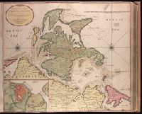
"Aende nieuwe-brug met previlegie"., Backed with paper. Ms. no. "10" in upper right-hand corner. Sheet measures 53.5 x 62.5 cm. No. 9 of 87 maps bound together., Bar scale given in "Duytsche Myl"., Relief shown pictorially; depths shown by soundings., Watermark., and With north oriented towards upper left.
Publisher:
By Gerard van Keulen,
Subject (Geographic):
Wismar (Germany)--Maps--Early works to 1800.
Subject (Topic):
Nautical charts--Germany--Wismar Bay--Early works to 1800.
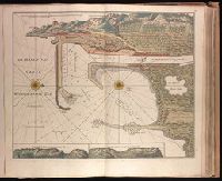
"Aen de nieuwen brugh met previlegi"., Backed with paper. Ms. no. "58" in upper right-hand corner. Sheet measures 53.7 x 62.3 cm. No. 53 of 87 maps bound together., Bar scale given in "Duytsche Myl"., Relief shown pictorially; depths shown by soundings., With north oriented towards the right., and With two inset maps at bottom: "Caap Cette N W ten N4" and "Caap Cette N W ten W 3."
Publisher:
By Gerard van Keulen,
Subject (Geographic):
Sète (France)--Maps--Early works to 1800.
Subject (Topic):
Nautical charts--France--Sète--Early works to 1800.
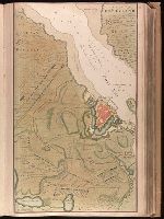
Backed with paper. Ms. no. "13" in upper right-hand corner. Sheet measures 53.6 x 35.5 cm. No. 13 of 87 maps bound together., Bar scale given in "Duytsche Mylen"., Relief shown pictorially; depths shown by soundings., Shows troop positions during siege of Stralsund during the Northern War, ca. 1715., and Title derived from place locations on map.
Publisher:
By Gerard van Keulen ...,
Subject (Geographic):
Rügen Island (Germany)--Maps--Early works to 1800. and Stralsund (Germany)--Maps--Early works to 1800.
Subject (Name):
Anse, Luggert van, fl. 1690-1716, engraver.
Subject (Topic):
Nautical charts--Baltic Sea--Early works to 1800. and Northern War, 1700-1721--Maps.
Haven en Stad Wismar and Stad Wismar met alles desselfs Sterktens.
Description:
"Aen de niuwe brugh met previlegie"., Appeared in Gerard van Keulen's Nieuwe groote ligtende Zee-Fakkel ... 1734; cf. Koeman, C. Atlantes Neerlandici, IV, Keu 45, map 22., Backed with paper. Ms. no. "9" [partially trimmed] in upper right-hand corner. Sheet measures 53.5 x 62.5 cm. No. 8 of 87 maps bound together., Bar scale given in "Duytsche Myl"., Includes inset map "De stad Wismar met alles desselfs Sterktens"., Relief shown pictorially; depths shown by soundings., and Watermark.
Publisher:
By Gerard van Keulen,
Subject (Geographic):
Wismar (Germany)--Maps--Early works to 1800.
Subject (Name):
Keulen, Gerard van. Nieuwe groote lichtende zee-fakkel.
Subject (Topic):
Nautical charts--Germany--Wismar Bay--Early works to 1800.
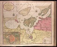
"Met previlegie.", Appeared in Gerard van Keulen's Nieuwe groote ligtende Zee-Fakkel ... 1734; cf. Koeman, C. Atlantes Neerlandici, IV, Keu 45, map 26., Backed with paper. Ms. no. "13" in upper right-hand corner. Sheet measures 53.6 x 62.8 cm. No. 12 of 87 maps bound together., Bar scale given in "Duytsche Mylen"., Includes inset map: De stad Straalsund / L. v. Ansée s., Relief shown pictorially; depths shown by soundings., and Watermark.
Publisher:
By Gerard van Keulen ...,
Subject (Geographic):
Rügen Island (Germany)--Maps--Early works to 1800. and Stralsund (Germany)--Maps--Early works to 1800.
Backed with paper. Ms. no. "66" in upper right-hand corner. Sheet measures 53.7 x 62.3 cm. No. 61 of 87 maps bound together., Includes four bar scales., Relief shown pictorially; depths shown by soundings., and With north oriented to the left.
Publisher:
By Gerard van Keulen, aen de nieuwe Brug met privilegie,
Subject (Geographic):
Sardinia (Italy)--Maps--Early works to 1800.
Subject (Topic):
Nautical charts--Mediterranean Sea--Early works to 1800.
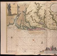
Appeared in various editions of Gerard van Keulen's Groote nieuwe Vermeerderde Zee-Atlas ofte Water-Werelt and Nieuwe groote ligtende Zee-Fakkel., Bar scales given in "Duytsche Mylen" and "Engelse en France Mylen.", Imperfect: stains at bottom, with no loss of text. Backed with paper. Ms. no. "94" in upper right-hand corner. Joined sheets measure 53.5 x 65.0 sm. or smaller. No. 84 of 87 maps bound together., Includes illustrations and decorative cartouche., Includes inset: "Afteekening van t'inkomen van de rivier van Suriname...", Oriented with south at the top., Relief shown pictorially; depths shown by soundings., and With north oriented towards the bottom.
Publisher:
By Gerard van Keulen,
Subject (Geographic):
Suriname--Maps--Early works to 1800.
Subject (Name):
Keulen, Gerard van. Groote nieuwe vermeerderde zee-atlas ofte water-waereld. and Keulen, Gerard van. Nieuwe groote lichtende zee-fakkel.
Subject (Topic):
Coasts--Suriname--Maps--Early works to 1800., Nautical charts--Suriname--Early works to 1800., and Rivers--Suriname--Maps--Early works to 1800.