Search
You Searched For
Search Results
- Creator:
- Marker, J. P
- Published / Created:
- undated
- Call Number:
- WA MSS 328
- Image Count:
- 1
- Resource Type:
- Maps, Atlases & Globes
- Found in:
- Beinecke Rare Book and Manuscript Library > Map of the ’Great Blue-Gravel Lead’ of Northern California /by J. P. Marker
- Published / Created:
- Undated
- Call Number:
- 1973 Folio 10
- Image Count:
- 1
- Resource Type:
- Maps, Atlases & Globes
- Found in:
- Beinecke Rare Book and Manuscript Library > A view of Prince Charles's passage over ye Rhine being a new and correct plan of that river from ye city of Maintz to Fort Louis
- Creator:
- Payne, John, active 1800, cartographer.
- Call Number:
- 3614 1792
- Image Count:
- 1
- Resource Type:
- Maps, Atlases & Globes
- Found in:
- Beinecke Rare Book and Manuscript Library > The Kingdom of Bohemia, 1792 / Ferguson sculp.
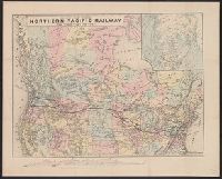
- Creator:
- National Railway Publication Company
- Call Number:
- BrSides Zc19 N82h 870na
- Image Count:
- 1
- Resource Type:
- Maps, Atlases & Globes
- Found in:
- Beinecke Rare Book and Manuscript Library > Map of the Northern Pacific Railway and tributary country.
- Creator:
- Speed, John, 1552?-1629
- Call Number:
- Lanman 50 1676
- Image Count:
- 2
- Resource Type:
- Maps, Atlases & Globes
- Found in:
- Beinecke Rare Book and Manuscript Library > A newe mape of Tartary / augmented by John Speed and are to be sold by Tho. Bassett in Fleet Street & Richard Chiswell in St. Pauls Churchyard ; Dirck Grÿp, sculp.
- Creator:
- Walton, Robert, 1618-1688
- Call Number:
- Lanman 11 1659A
- Image Count:
- 1
- Resource Type:
- Maps, Atlases & Globes
- Found in:
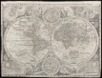
- Beinecke Rare Book and Manuscript Library > A new and accvrat map of the world : drawne according to ye truest descriptions latest discoveries & best observations y[e]t have beene made by English or strangers.
- Call Number:
- BrSides Double Folio 2017 38
- Image Count:
- 1
- Resource Type:
- Maps, Atlases & Globes
- Found in:
- Beinecke Rare Book and Manuscript Library > The theatre of war in North America, with the roads, and tables, of the superficial contents, distances, & ca. / by an American.
- Call Number:
- BrSides Double Folio 2017 26
- Image Count:
- 1
- Resource Type:
- Maps, Atlases & Globes
- Found in:
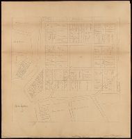
- Beinecke Rare Book and Manuscript Library > New Haven in 1641.
- Creator:
- Bowditch, Ernest W
- Call Number:
- BrSides Zc39 888bp
- Image Count:
- 1
- Resource Type:
- Maps, Atlases & Globes
- Found in:
- Beinecke Rare Book and Manuscript Library > Plan of property belonging to the Topeka Land & Development Co., Topeka, Kan. / Ernest W. Bowditch, engineer.
- Creator:
- Sanborn Map & Publishing Co., issuing body
- Call Number:
- 766 C67 1884
- Image Count:
- 2
- Found in:
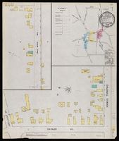
- Beinecke Rare Book and Manuscript Library > Colchester, Conn.
- Creator:
- Sanborn-Perris Map Co., issuing body
- Call Number:
- 766 C67 1892
- Image Count:
- 3
- Found in:
- Beinecke Rare Book and Manuscript Library > Colchester, New London Co., Conn.
- Creator:
- Sanborn-Perris Map Co., issuing body
- Call Number:
- 766 C67 1897
- Image Count:
- 3
- Found in:
- Beinecke Rare Book and Manuscript Library > Colchester, New London Co., Conn.
- Creator:
- Sanborn Map Company, issuing body
- Call Number:
- 766 C67 1903
- Image Count:
- 3
- Found in:
- Beinecke Rare Book and Manuscript Library > Colchester, New London Co., Connecticut.
- Published / Created:
- .
- Call Number:
- 5684 1905
- Container / Volume:
- BRBL_00300
- Image Count:
- 1
- Resource Type:
- Maps, Atlases & Globes
- Found in:
- Beinecke Rare Book and Manuscript Library > The Regent's Sword Peninsula.
- Published / Created:
- undated
- Call Number:
- WA MSS S-2162
- Collection Title:
- Frank Richard Oastler collection
- Container / Volume:
- Box 69 | Folder 71
- Image Count:
- 1
- Found in:
- Beinecke Rare Book and Manuscript Library > Printed map previously in the envelope at the front of 1915 Wyoming Album I
- Call Number:
- 766 N46 1917
- Container / Volume:
- BRBL_00473A
- Image Count:
- 15
- Resource Type:
- Maps, Atlases & Globes
- Found in:
- Beinecke Rare Book and Manuscript Library > [City of New Haven] 1913-1917.
- Call Number:
- 774 P53 1794
- Container / Volume:
- BRBL_00499
- Image Count:
- 1
- Resource Type:
- Maps, Atlases & Globes
- Found in:
- Beinecke Rare Book and Manuscript Library > To Thomas Mifflin / Governor and Commander in Chief of The State of Pennsylvania / This Plan of the City and Suburbs of Philadelphia Is respectfully inscribed by the Editor [Folie?] 1794.
- Call Number:
- 734 M769 1906
- Container / Volume:
- BRBL_00380
- Image Count:
- 1
- Resource Type:
- Maps, Atlases & Globes
- Found in:
- Beinecke Rare Book and Manuscript Library > Map of Montreal, Canada [cartographic material].
- Call Number:
- 735 1790
- Container / Volume:
- BRBL_00689
- Image Count:
- 1
- Resource Type:
- Maps, Atlases & Globes
- Found in:
- Beinecke Rare Book and Manuscript Library > A map shewing the communication of the lakes and the rivers between Lake Superior and Slave Lake in North America.
- Creator:
- Dunn, Samuel, d. 1794
- Call Number:
- 71 1776
- Container / Volume:
- BRBL_00687
- Image Count:
- 1
- Resource Type:
- Maps, Atlases & Globes
- Found in:
- Beinecke Rare Book and Manuscript Library > A map of the British Empire, in North America / by Samuel Dunn, mathematician, improved from the surveys of Capt. Carver.
- Call Number:
- 11ba 1915
- Container / Volume:
- BRBL_00010A
- Image Count:
- 1
- Resource Type:
- Maps, Atlases & Globes
- Found in:
- Beinecke Rare Book and Manuscript Library > [Philips' 12 inch terrestrial globe.]
- Creator:
- Moll, Herman, d. 1732
- Call Number:
- 85 1745A
- Container / Volume:
- BRBL_00636
- Image Count:
- 1
- Resource Type:
- Maps, Atlases & Globes
- Found in:
- Beinecke Rare Book and Manuscript Library > A chart of ye West-Indies or the islands of America in the North Sea &c., being ye present seat of war / by Herman Moll, geographer.
- Creator:
- Alaska Communication System
- Call Number:
- 848gmh 1950
- Container / Volume:
- BRBL_00635
- Image Count:
- 1
- Resource Type:
- Maps, Atlases & Globes
- Found in:
- Beinecke Rare Book and Manuscript Library > Alaska Communications System : chart of Alaska showing stations to which commercial communication service is available / prepared by Alaska Communication System [and] Signal Corps, Department of the Army ; Cartography and format Northwest Mapping Service.
- Creator:
- Thomas Bros. Maps
- Call Number:
- 844 Or6 1928
- Container / Volume:
- BRBL_00607
- Image Count:
- 2
- Resource Type:
- Maps, Atlases & Globes
- Found in:
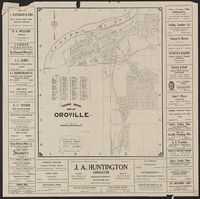
- Beinecke Rare Book and Manuscript Library > Thomas Bros. map of Oroville / compiled and published by Thomas Bros. map specialties.
- Creator:
- Bruné, F. F
- Call Number:
- 834gfc Sp22 1873
- Container / Volume:
- BRBL_00590
- Image Count:
- 2
- Resource Type:
- Maps, Atlases & Globes
- Found in:
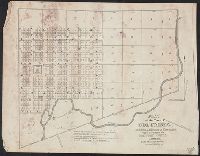
- Beinecke Rare Book and Manuscript Library > Map of Spanish Bar District, Clear Creek Co., Colorado Territory : showing location of tunnel & mining claims, mill sites & water powers / surveyed & platted by F.F. Brunè, co. surveyor, Clear Creek Co., Colorado.
- Creator:
- United States. General Land Office
- Call Number:
- 833 1879
- Container / Volume:
- BRBL_00584
- Image Count:
- 1
- Resource Type:
- Maps, Atlases & Globes
- Found in:
- Beinecke Rare Book and Manuscript Library > Territory of Wyoming : 1879 / compiled from the official records of the General Land Office and other sources by C. Roeser, Principal Draughtsman, G.L.O.
- Creator:
- Tuttle-Ayers-Woodward Co
- Call Number:
- 816ad K134 1925
- Container / Volume:
- BRBL_00563
- Image Count:
- 29
- Resource Type:
- Maps, Atlases & Globes
- Found in:
- Beinecke Rare Book and Manuscript Library > Atlas of Kansas City, Missouri, and environs, 1925.
- Call Number:
- 8075cea 1848
- Container / Volume:
- BRBL_00551
- Image Count:
- 1
- Resource Type:
- Maps, Atlases & Globes
- Found in:
- Beinecke Rare Book and Manuscript Library > A Chart of Lake Erie ... Buffalo, A. Burke, 1848.
- Call Number:
- 805fcm C723 1841
- Container / Volume:
- BRBL_00546
- Image Count:
- 1
- Resource Type:
- Maps, Atlases & Globes
- Found in:
- Beinecke Rare Book and Manuscript Library > Plat of the Town of Columbia ... Whitley county. Elihu Chauncey, Proprietor.
- Creator:
- Texas. General Land Office
- Call Number:
- 796 B468 1879
- Container / Volume:
- BRBL_00527
- Image Count:
- 1
- Resource Type:
- Maps, Atlases & Globes
- Found in:
- Beinecke Rare Book and Manuscript Library > Map of Bexar County.
- Call Number:
- 787 1818
- Container / Volume:
- BRBL_00516
- Image Count:
- 4
- Resource Type:
- Maps, Atlases & Globes
- Found in:
- Beinecke Rare Book and Manuscript Library > Map of the State of Georgia prepared from actual surveys and other documents for Eleazer Early [by] Daniel Sturges.
- Call Number:
- 785cea H214 1837
- Container / Volume:
- BRBL_00514
- Image Count:
- 1
- Resource Type:
- Maps, Atlases & Globes
- Found in:
- Beinecke Rare Book and Manuscript Library > No.1. Harbor Island Bar Entrance into Core Sound N.C. Surveyed under ... Drawn by T. J. Lee & L. Sitgreaves.
- Call Number:
- 785cea C81 1837A
- Container / Volume:
- BRBL_00514
- Image Count:
- 1
- Resource Type:
- Maps, Atlases & Globes
- Found in:
- Beinecke Rare Book and Manuscript Library > Core Sound North Carolina, surveyed under ...1837.
- Call Number:
- 783hc 1781
- Container / Volume:
- BRBL_00511
- Image Count:
- 4
- Resource Type:
- Maps, Atlases & Globes
- Found in:
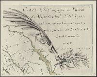
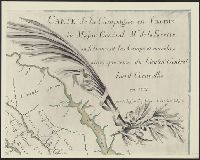
- Beinecke Rare Book and Manuscript Library > Campagne en Virginie du Major Général M. de La Fayette, ou se trouvent les Camps et Marches ainsy que ceux du Lieutenant Général Ld. Cornwallis, par le Major Capitaine, Aide de Camp de Gl. La Fayette en 1781.
- Call Number:
- 783hc 1781
- Container / Volume:
- BRBL_00511
- Image Count:
- 4
- Resource Type:
- Maps, Atlases & Globes
- Found in:
- Beinecke Rare Book and Manuscript Library > Campagne en Virginie du Major Général M. de La Fayette, ou se trouvent les Camps et Marches ainsy que ceux du Lieutenant Général Ld. Cornwallis, par le Major Capitaine, Aide de Camp de Gl. La Fayette en 1781.
- Call Number:
- 783 R41 1866
- Container / Volume:
- BRBL_00510
- Image Count:
- 2
- Resource Type:
- Maps, Atlases & Globes
- Found in:
- Beinecke Rare Book and Manuscript Library > Johnson's map of the vicinity of Richmond and peninsular campaing in Virginia ... By Johnson and Ward.
- Call Number:
- 783 C899 1863B
- Container / Volume:
- BRBL_00510
- Image Count:
- 1
- Resource Type:
- Maps, Atlases & Globes
- Found in:
- Beinecke Rare Book and Manuscript Library > Military and topographic map of region about Culpepper Courthouse, Va.
- Call Number:
- 783 1809
- Container / Volume:
- BRBL_00508
- Image Count:
- 1
- Resource Type:
- Maps, Atlases & Globes
- Found in:
- Beinecke Rare Book and Manuscript Library > The State of Virginia from the best Authorities, By Samuel Lewis. 1809.
- Call Number:
- 783 1775
- Container / Volume:
- BRBL_00507
- Image Count:
- 3
- Resource Type:
- Maps, Atlases & Globes
- Found in:
- Beinecke Rare Book and Manuscript Library > A map of the most inhabited part of Virginia part of Pensilvania, new Yersey & North Carolina.
- Call Number:
- 783 1673D
- Container / Volume:
- BRBL_00507
- Image Count:
- 1
- Resource Type:
- Maps, Atlases & Globes
- Found in:
- Beinecke Rare Book and Manuscript Library > virginia and Maryland. As it is planted and inhabited this present year 1670. Surveyed and Exactly Drawne by ... Augustin Herrman, 1673.
- Call Number:
- 779hc W27 1861
- Container / Volume:
- BRBL_00505A
- Image Count:
- 1
- Resource Type:
- Maps, Atlases & Globes
- Found in:
- Beinecke Rare Book and Manuscript Library > Plan of "Cantonment Spargue" near Washington D.C. occupied by 1st Regiment, R.I. Detached Militia. as laid out under the direction of Col. A.E. Burnside ... by Lieut. H.A. DeWitt, Engineer. May 1861.
- Call Number:
- 779 W27 1792A
- Container / Volume:
- BRBL_00505
- Image Count:
- 1
- Resource Type:
- Maps, Atlases & Globes
- Found in:
- Beinecke Rare Book and Manuscript Library > Plan of the City of Washington in the territory of Columbia. Ceded by the States of Virginia and Maryland to the United States of America and by them established as the Seat of their Government. After the year MDCCC.
- Call Number:
- 777 C425 1799
- Container / Volume:
- BRBL_00503
- Image Count:
- 1
- Resource Type:
- Maps, Atlases & Globes
- Found in:
- Beinecke Rare Book and Manuscript Library > A map of the head of the Chesapeake Bay and Susquehanna River shewing the navigation of the same with a topographical description of the surrounding country from an actual survey by C.P. Hauducoeur 1799.
- Call Number:
- 776 1801
- Container / Volume:
- BRBL_00502
- Image Count:
- 1
- Resource Type:
- Maps, Atlases & Globes
- Found in:
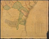
- Beinecke Rare Book and Manuscript Library > A map of Delaware and eastern shore of Maryland with the soundings of the Bay of Delaware from actual survey & soundings made in 1799, 1800 & 1801 by the Author.
- Call Number:
- 774gme 1840B
- Container / Volume:
- BRBL_00501A
- Image Count:
- 1
- Resource Type:
- Maps, Atlases & Globes
- Found in:
- Beinecke Rare Book and Manuscript Library > Map exhibiting that portion of the state of Pennsylvania traversed by the surveys for a continous railroad from Harrisburg to Pittsburg, 1839-40.
- Call Number:
- 774CA AL53 1824
- Container / Volume:
- BRBL_00501
- Image Count:
- 1
- Resource Type:
- Maps, Atlases & Globes
- Found in:
- Beinecke Rare Book and Manuscript Library > Plan and Profile of the Allegany Mountain between the head waters of Blair's Greek, a branch of the Juniata and the mountain branch of the Conemaugh 1824.
- Call Number:
- 774 B856 1820
- Container / Volume:
- BRBL_00499
- Image Count:
- 1
- Resource Type:
- Maps, Atlases & Globes
- Found in:
- Beinecke Rare Book and Manuscript Library > A map of Buck Mountain coal company mines exhibiting their relative position to the Lehigh slack water navigation and the different coal mines now opened in the region. Drawn by A.L. Foster of J. Collins 1820 (?) Lith.
- Call Number:
- 771hc B796 1776A
- Container / Volume:
- BRBL_00495
- Image Count:
- 1
- Resource Type:
- Maps, Atlases & Globes
- Found in:
- Beinecke Rare Book and Manuscript Library > [Map of Brooklyn, N.Y., showing the battle in this area in 1776, superimposed upon a modern street map.]
- Call Number:
- 771gmb 1808
- Container / Volume:
- BRBL_00494
- Image Count:
- 1
- Resource Type:
- Maps, Atlases & Globes
- Found in:
- Beinecke Rare Book and Manuscript Library > A map of the State of New York ... including the Turnpike Roads ... By Wm. McGalpin, Oxford, 1808.
- Call Number:
- 771gma ER41 1811
- Container / Volume:
- BRBL_00494
- Image Count:
- 1
- Resource Type:
- Maps, Atlases & Globes
- Found in:
- Beinecke Rare Book and Manuscript Library > Map of the Western Part of the State of New York shewing the route of a proposed Canal from Lake Erie to Hudson's River Compiled by John H. Eddy from the best authorities 1811.
- Published / Created:
- [n.d.]
- Call Number:
- Cc5 5 2.1
- Image Count:
- 1
- Found in:
- Beinecke Rare Book and Manuscript Library > Map showing the relative position of Rock Island, with the North Western states and territories
- Call Number:
- 771ed 1614
- Container / Volume:
- BRBL_00493
- Image Count:
- 1
- Resource Type:
- Maps, Atlases & Globes
- Found in:
- Beinecke Rare Book and Manuscript Library > The original Carte Figurative of which the above is an accurate facsimile was found on the 26th June 1841 in the Loket Kas of the States General in the Royal Archives at the Haque, It may be the one referred to in Octroy of the States General dated 11th O
- Creator:
- Cary, John, approximately 1754-1835, cartographer
- Call Number:
- 401 1811
- Container / Volume:
- BRBL_00233
- Image Count:
- 1
- Resource Type:
- Maps, Atlases & Globes
- Found in:
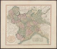
- Beinecke Rare Book and Manuscript Library > A new map of Piedmont, the duchies of Savoy and Milan, and the republic of Genoa, with their subdivisions : from the latest authorities / by John Cary.
- Creator:
- Hewitt, N. R., cartographer
- Call Number:
- 4037 1816
- Container / Volume:
- BRBL_00234A
- Image Count:
- 1
- Resource Type:
- Maps, Atlases & Globes
- Found in:
- Beinecke Rare Book and Manuscript Library > Venetian States [cartographic material] / drawn & engraved by N.R. Hewitt, Charlotte Strt., Fitzroy Square ; drawn and engraved for Thomson's New general atlas, 1816.
- Call Number:
- 771 W528 1867
- Container / Volume:
- BRBL_00492
- Image Count:
- 1
- Resource Type:
- Maps, Atlases & Globes
- Found in:
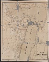
- Beinecke Rare Book and Manuscript Library > Map of West Point.
- Call Number:
- 771 R297 1767
- Container / Volume:
- BRBL_00490
- Image Count:
- 1
- Resource Type:
- Maps, Atlases & Globes
- Found in:
- Beinecke Rare Book and Manuscript Library > Map of the Manor Rensel aerwick surveyed and laid down by a scale of 100 chains to an inch by Jno. R. Bleeker, Surveyor 1767.
- Call Number:
- 771 OS9 1836
- Container / Volume:
- BRBL_00490
- Image Count:
- 1
- Resource Type:
- Maps, Atlases & Globes
- Found in:
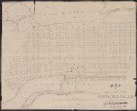
- Beinecke Rare Book and Manuscript Library > map of the Village of Oswego Falls to be Sold on hte Premises by Jas. Bleecker & Sons on the 18th October 1836.
- Call Number:
- 771 ON8 1797
- Container / Volume:
- BRBL_00490
- Image Count:
- 1
- Resource Type:
- Maps, Atlases & Globes
- Found in:
- Beinecke Rare Book and Manuscript Library > A map of Messrs. Gorham and Phelp's Purchase; now the County of Ontario in the State of New York From actual survey by A. Porter Engraved by A. Doolitle, New Haven.
- Call Number:
- 771 Og21 1836
- Image Count:
- 1
- Resource Type:
- Maps, Atlases & Globes
- Found in:
- Beinecke Rare Book and Manuscript Library > Map of Ogdensburgh in the County of St. Lawrence New-York. From Surveys by R. Tate and Sons Civil Engineers. 1836.
- Creator:
- Morrison, Thomas
- Call Number:
- 771 H864 1840
- Container / Volume:
- BRBL_00483
- Image Count:
- 1
- Resource Type:
- Maps, Atlases & Globes
- Found in:
- Beinecke Rare Book and Manuscript Library > Morrison's new map of the Hudson River, : with a description of the adjoining country; a list of all the principal hotels in the City of New York, their location and by whom kept, & c &c. Also, the distances of the different towns, &c. on the canal, from
- Creator:
- Rand McNally and Company
- Call Number:
- 771 1883
- Container / Volume:
- BRBL_00479
- Image Count:
- 1
- Resource Type:
- Maps, Atlases & Globes
- Found in:
- Beinecke Rare Book and Manuscript Library > Rand, McNally & Co.'s new railroad, county and township map of New York : showing every railroad station and post office in the state.
- Creator:
- Colton, G. Woolworth (George Woolworth), 1827-1901
- Call Number:
- 771 1869C
- Container / Volume:
- BRBL_00479
- Image Count:
- 1
- Resource Type:
- Maps, Atlases & Globes
- Found in:
- Beinecke Rare Book and Manuscript Library > Colton's railroad & township map of the state of New York : with parts of the adjoining states & Canada / drawn by Geo. W. Colton ; J.M. Atwood, sculpt.
- Creator:
- Great Britain. Hydrographic Department, author
- Call Number:
- 254cea 1886
- Container / Volume:
- BRBL_00021
- Image Count:
- 1
- Resource Type:
- Maps, Atlases & Globes
- Found in:
- Beinecke Rare Book and Manuscript Library > Australia, Coral Sea and Great Barrier Reefs, showing the Inner and Outer routes to Torres Strait. Sheet 2 / engraved by Edwd. Weller.
- Call Number:
- 32gme L84 1836
- Container / Volume:
- BRBL_00076
- Image Count:
- 1
- Resource Type:
- Maps, Atlases & Globes
- Found in:
- Beinecke Rare Book and Manuscript Library > Map showing elevation between Parish of Harlow and Parish of Birchanger.
- Creator:
- Royal Geographical Society (Great Britain). Geographical Section, cartographer
- Call Number:
- 11hcf 1919E-23
- Container / Volume:
- BRBL_00010ZA
- Image Count:
- 1
- Resource Type:
- Maps, Atlases & Globes
- Found in:
- Beinecke Rare Book and Manuscript Library > Milano [cartographic material] : North L. 32. / compiled at the Royal Geographical Society under the direction of the Geographical Section; drawn and printed by Ordnance Survey.
- Creator:
- Sampson, Davenport & Co., creator
- Call Number:
- 765 P94 1877
- Container / Volume:
- BRBL_00464
- Image Count:
- 2
- Resource Type:
- Maps, Atlases & Globes
- Found in:
- Beinecke Rare Book and Manuscript Library > Map of the city of Providence, Rhode Island / compiled from the most authentic sources by H.F. Walling, typographical engineer.
- Creator:
- Price & Lee Co., author
- Call Number:
- 766 N46 1880B
- Container / Volume:
- BRBL_00472
- Image Count:
- 2
- Resource Type:
- Maps, Atlases & Globes
- Found in:
- Beinecke Rare Book and Manuscript Library > Price, Lee & Co. new map of the City of New Haven / surveyed by S.W. Searle, surveyor and civil engineer and drawn by him expressly for their new city directory.
- Creator:
- Robert Sayer and John Bennett (Firm)
- Call Number:
- 755 1776K
- Container / Volume:
- BRBL_00430
- Image Count:
- 1
- Resource Type:
- Maps, Atlases & Globes
- Found in:
- Beinecke Rare Book and Manuscript Library > A general map of the northern British colonies in America : which comprehends the province of Quebec, the government of Newfoundland, Nova-Scotia, New-England and New-York, from the maps published by the Admiralty and Board of Trade, regulated by the astr
- Creator:
- Robert Sayer and John Bennett (Firm)
- Call Number:
- 755 1776G
- Container / Volume:
- BRBL_00430
- Image Count:
- 1
- Resource Type:
- Maps, Atlases & Globes
- Found in:
- Beinecke Rare Book and Manuscript Library > A general map of the Northern British Colonies in America, which comprehends the Province of Quebec, the government of Newfoundland, Nova-Scotia, New-England and New York : from the surveys of Capt. Cook & Capt. Carver, regulated by the astronomic & trigo
- Published / Created:
- .
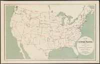
- Call Number:
- 75H 1895
- Container / Volume:
- BRBL_00414A
- Image Count:
- 1
- Resource Type:
- Maps, Atlases & Globes
- Found in:
- Beinecke Rare Book and Manuscript Library > Map of the United States showing Military Posts and Principal Lines of Communication / Prepared by direction of the Secretary of War in the Office of the Chief of Engineers U.S.A.
- Creator:
- Rand McNally and Company
- Call Number:
- 75gme 1872
- Container / Volume:
- BRBL_00412
- Image Count:
- 1
- Resource Type:
- Maps, Atlases & Globes
- Found in:
- Beinecke Rare Book and Manuscript Library > Railway and distance map accompanying Rand, McNally & Co.'s Railway Guide.
- Call Number:
- 739 B94 1929B
- Container / Volume:
- BRBL_00389
- Image Count:
- 1
- Resource Type:
- Maps, Atlases & Globes
- Found in:
- Beinecke Rare Book and Manuscript Library > Howe Sound - Burrard Inlet / ǂc [by] Survey Branch, Department of Lands and Greater Vancouver Water District.
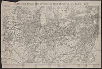
- Creator:
- National Railway Publication Company
- Call Number:
- 71gme 1870
- Container / Volume:
- BRBL_00372
- Image Count:
- 1
- Resource Type:
- Maps, Atlases & Globes
- Found in:
- Beinecke Rare Book and Manuscript Library > Map of the Northern Pacific Railway and tributary country.
- Creator:
- Vidal, A. T. E. (Alexander Thomas Emeric), 1792-1863, author
- Call Number:
- 655 1827
- Container / Volume:
- BRBL_00345
- Image Count:
- 1
- Resource Type:
- Maps, Atlases & Globes
- Found in:
- Beinecke Rare Book and Manuscript Library > The west coast of Africa : from latitude 1°, 35ʹ N. to 5°, 50ʹ N. and from longitude 4, 55 E. to 10, 45 E. / by Captn. A.T.E. Vidal & the officers of H.M. Sloop Barracouta under the orders of Captn. W.F.W. Owen, 1826 ; J. & C. Walker, sculpt.
- Creator:
- Bowen, Emanuel, d. 1767
- Call Number:
- 623 1750
- Container / Volume:
- BRBL_00333
- Image Count:
- 1
- Resource Type:
- Maps, Atlases & Globes
- Found in:
- Beinecke Rare Book and Manuscript Library > A new and accurate map of Nubia & Abissinia, together with all the kingdoms tributary thereto, and bordering upon them / laid down from the latest & best authorities and regulated by astronl. observations ny Emanl. Bowen.
- Creator:
- Delarochette, L. (Louis), 1731-1802, cartographer
- Call Number:
- 61 1833
- Container / Volume:
- BRBL_00330
- Image Count:
- 1
- Resource Type:
- Maps, Atlases & Globes
- Found in:
- Beinecke Rare Book and Manuscript Library > Lower Egypt and the adjacent deserts, with a part of Palestine : to which has been added the nomenclature of the Roman age / by L.S. De La Rochette.
- Creator:
- W. & A.K. Johnston Limited, cartographer
- Call Number:
- 60 1889
- Container / Volume:
- BRBL_00327
- Image Count:
- 1
- Resource Type:
- Maps, Atlases & Globes
- Found in:
- Beinecke Rare Book and Manuscript Library > Sketch map to illustrate H. M. Stanley's route in the Emin Relief Expedition / drawn by W. and A.K. Johnston.
- Call Number:
- 60 1877
- Container / Volume:
- BRBL_00327
- Image Count:
- 1
- Resource Type:
- Maps, Atlases & Globes
- Found in:
- Beinecke Rare Book and Manuscript Library > Map illustrating Comr V.L. Cameron's route across Africa, 1873-5 / compiled from his original documents by W.J. Turner.
- Creator:
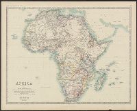
- Johnston, Alexander Keith, 1804-1871, author
- Call Number:
- 60 1861
- Container / Volume:
- BRBL_00326
- Image Count:
- 1
- Resource Type:
- Maps, Atlases & Globes
- Found in:
- Beinecke Rare Book and Manuscript Library > Africa / by Keith Johnston, F.R.S.E.
- Creator:
- Johnston, Alexander Keith, 1804-1871, author
- Call Number:
- 60 1860A
- Container / Volume:
- BRBL_00326
- Image Count:
- 1
- Resource Type:
- Maps, Atlases & Globes
- Found in:
- Beinecke Rare Book and Manuscript Library > Africa.
- Creator:
- Lapie, M. (Pierre), 1779-1850
- Call Number:
- 60 1795
- Container / Volume:
- BRBL_00324
- Image Count:
- 1
- Resource Type:
- Maps, Atlases & Globes
- Found in:
- Beinecke Rare Book and Manuscript Library > General map of Africa : corrected according to the best observations and discovereies of the most recent travels / prepared by Citn. Lapie ; under the direction of the author.
- Call Number:
- 59 C126 1890
- Container / Volume:
- BRBL_00318
- Image Count:
- 1
- Resource Type:
- Maps, Atlases & Globes
- Found in:
- Beinecke Rare Book and Manuscript Library > Plan of the Town of Calcutta.
- Call Number:
- 39hc C11 1797
- Container / Volume:
- BRBL_00192
- Image Count:
- 1
- Resource Type:
- Maps, Atlases & Globes
- Found in:
- Beinecke Rare Book and Manuscript Library > Plan of the harbour of Cadiz : from the chart of D. Vicente Tofiño : with the blockade by the British fleet under the command of the right honble. Earl of St. Vincent / engraved by T. Foot.
- Creator:
- Wyld, James, 1790-1836, cartographer
- Call Number:
- 39hc Sa54 1813
- Container / Volume:
- BRBL_00192
- Image Count:
- 1
- Resource Type:
- Maps, Atlases & Globes
- Found in:
- Beinecke Rare Book and Manuscript Library > The country between St. Sebastian and the French frontier : compiled principally from the sketches of Major J.H. Humfrey ... / J. Wyld del. et sculp.
- Creator:
- Arrowsmith, John, 1790-1873
- Call Number:
- 39 1852
- Collection Title:
- [London atlas of universal geography]
- Container / Volume:
- BRBL_00188
- Image Count:
- 1
- Resource Type:
- Maps, Atlases & Globes
- Found in:
- Beinecke Rare Book and Manuscript Library > Spain & Portugal [cartographic material] / by J. Arrowsmith.
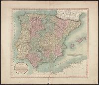
- Creator:
- Cary, John, approximately 1754-1835
- Call Number:
- 39 1801
- Container / Volume:
- BRBL_00186
- Image Count:
- 1
- Resource Type:
- Maps, Atlases & Globes
- Found in:
- Beinecke Rare Book and Manuscript Library > A new map of Spain and Portugal : divided into their respective kingdoms and provinces from the latest authorities / by John Cary, engraver.
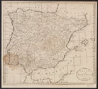
- Call Number:
- 39 1795
- Container / Volume:
- BRBL_00186
- Image Count:
- 1
- Resource Type:
- Maps, Atlases & Globes
- Found in:
- Beinecke Rare Book and Manuscript Library > Spain and Portugal, from the best authorities.
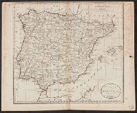
- Call Number:
- 39 1795
- Container / Volume:
- BRBL_00186
- Image Count:
- 1
- Resource Type:
- Maps, Atlases & Globes
- Found in:
- Beinecke Rare Book and Manuscript Library > Spain and Portugal, from the best authorities.
- Creator:
- Cary, John, approximately 1754-1835
- Call Number:
- 3614 1799
- Container / Volume:
- BRBL_00135
- Image Count:
- 1
- Resource Type:
- Maps, Atlases & Globes
- Found in:
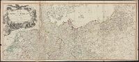
- Beinecke Rare Book and Manuscript Library > A new map of the Kingdom of Prussia : with its divisions into provinces and governments ; from the latest authorities / by John Cary, engraver, 1799.
- Creator:
- Roberts, John, engraver and geographer
- Call Number:
- 3614 1794
- Collection Title:
- New universal atlas.
- Container / Volume:
- BRBL_00135
- Image Count:
- 1
- Resource Type:
- Maps, Atlases & Globes
- Found in:
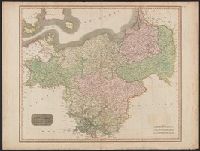
- Beinecke Rare Book and Manuscript Library > The kingdom of Prussia, and its newly incorporated province of Polish Prussia now named Western Prussia : with the territory of Dantzick / by John Roberts, Geographer.
- Creator:
- Thomson, John, active 19th century
- Call Number:
- 361 1817
- Container / Volume:
- BRBL_00135
- Image Count:
- 1
- Resource Type:
- Maps, Atlases & Globes
- Found in:
- Beinecke Rare Book and Manuscript Library > Prussian Dominions / drawn and engraved for Thomson's New General atlas.
- Creator:
- Delarochette, L. (Louis), 1731-1802
Kitchin, Thomas, 1718-1784. New universal atlas. 1804
Laurie & Whittle
- Call Number:
- 36 1794B
- Container / Volume:
- BRBL_00119
- Image Count:
- 2
- Resource Type:
- Maps, Atlases & Globes
- Found in:
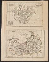
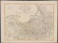
- Beinecke Rare Book and Manuscript Library > Map of the Empire of Germany : including all the states comprehended under that name: with the Kingdom of Prussia, &c. / by L. Delarochette ; T. Kitchin sculpt.
- Creator:
- Lefevre, Emily Shaw
Stanford, Edward, 1827-1904, author
- Call Number:
- 32fbc 1885
- Container / Volume:
- BRBL_00075
- Image Count:
- 1
- Resource Type:
- Maps, Atlases & Globes
- Found in:
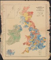
- Beinecke Rare Book and Manuscript Library > Stanford's Parliamentary election map of the British Isles : shewing the counties, divisions of counties & boroughs according to the Redistribution of Seats Act, 1885 / edited by E. Shaw Lefevre.
- Creator:
- Camden, William, d 1551-1623. Britannia. English
Churchill, Awnsham, -1728, publisher
Churchill, John, active 1690-1714, publisher
Morden, Robert, approximately 1650-1703, cartogra
Nicholls, Sutton, engraver
- Call Number:
- 3243 1690
- Container / Volume:
- BRBL_00066
- Image Count:
- 1
- Resource Type:
- Maps, Atlases & Globes
- Found in:
- Beinecke Rare Book and Manuscript Library > Cambridge shire / Sutton Nicholls sculp.
- Creator:
- Wyld, James, 1812-1887, cartographer
- Call Number:
- 32 L84 1888
- Container / Volume:
- BRBL_00051
- Image Count:
- 1
- Resource Type:
- Maps, Atlases & Globes
- Found in:
- Beinecke Rare Book and Manuscript Library > Environs of London.