Search
You Searched For
Search Results
- Creator:
- Bennett, R. (Richard), creator.
- Published / Created:
- [1765?]
- Call Number:
- 2017 Folio 49
- Image Count:
- 1
- Resource Type:
- Maps, Atlases & Globes
- Found in:
- Beinecke Rare Book and Manuscript Library > A new & accurate map of Germany including the seat of war in the Kingdom of Prussia, Bohemia, Lusatia, Silesia, Saxony, Westphalia &c. : also an exact table of the distances in German & English miles from town to town / by R. Bennett, engraver.
- Creator:
- Jaillot, Alexis Hubert, 1632?-1712, cartographer.
- Published / Created:
- 1736
- Call Number:
- 339 1736
- Container / Volume:
- BRBL_00090
- Image Count:
- 4
- Resource Type:
- Maps, Atlases & Globes
- Found in:
- Beinecke Rare Book and Manuscript Library > Le Duché de Luxembourg divisé en quartier Walon et Allemand : dans chacun desquels sont diviséz les seigneuries, prevostés et comtés, le duché de Bouillon, le comté de Namur et le pays entre Sembre et Meuse / dédié au Roy par son tres humble, tre
- Creator:
- New York (N.Y.). Board of Public Improvements.
- Published / Created:
- 1900
- Call Number:
- 771 N49 1900J
- Image Count:
- 4
- Resource Type:
- Maps, Atlases & Globes
- Found in:
- Beinecke Rare Book and Manuscript Library > Borough of Brooklyn, showing investigation and adjustment of monuments carried on by the Topographical Bureau.
- Creator:
- Arrowsmith, Aaron, 1750-1823, cartographer.
- Call Number:
- 71 1811
- Image Count:
- 4
- Resource Type:
- Maps, Atlases & Globes
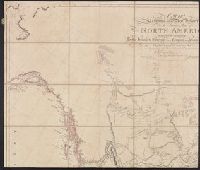
- Found in:
- Beinecke Rare Book and Manuscript Library > A map exhibiting all the new discoveries in the interior parts of North America [cartographic material] / inscribed by permission to the honorable governor and company of the adventurers of England trading into Hudsons Bay, in testimony of their liberal communications to their most obedient and very humble servant A. Arrowsmith, hydrographer to H.R.H. the Prince of Wales, January 1st 1795 ; Puke, sc.
- Creator:
- Rocque, John, -1762.
- Published / Created:
- [between 1762 and 1773]
- Call Number:
- 327 1785
- Image Count:
- 2
- Resource Type:
- Maps, Atlases & Globes
- Found in:
- Beinecke Rare Book and Manuscript Library > A map of the kingdom of Ireland : divided into provinces, counties and baronies, shewing the archbishopricks, bishopricks, cities, boroughs, market towns, villages, barracks, mountains, lakes, bogs, rivers, bridges, ferries, passes : also, the great, the branch and the by post roads, together with the inland navigation, &c. / by John Rocque ...
- Creator:
- United States. Army. Corps of Engineers.
- Published / Created:
- 1941
- Call Number:
- 60gmb 1941
- Image Count:
- 2
- Resource Type:
- Maps, Atlases & Globes
- Found in:
- Beinecke Rare Book and Manuscript Library > Map of central North Africa, including Lake Tchad / prepared under direction of the Chief of Engineers, U.S. Army.
- Creator:
- Mercator, Gerhard, 1512-1594, cartographer.
- Published / Created:
- [1605?]
- Call Number:
- 18 1605
- Image Count:
- 2
- Resource Type:
- Maps, Atlases & Globes
- Found in:
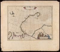
- Beinecke Rare Book and Manuscript Library > Septentrionalium terrarum descriptio / per Gerardum Mercatorem cum privilegio.
- Creator:
- Rocque, John, -1762.
- Published / Created:
- [between 1762 and 1773]
- Call Number:
- 327 1785
- Image Count:
- 2
- Resource Type:
- Maps, Atlases & Globes
- Found in:
- Beinecke Rare Book and Manuscript Library > A map of the kingdom of Ireland : divided into provinces, counties and baronies, shewing the archbishopricks, bishopricks, cities, boroughs, market towns, villages, barracks, mountains, lakes, bogs, rivers, bridges, ferries, passes : also, the great, the branch and the by post roads, together with the inland navigation, &c. / by John Rocque ...
- Call Number:
- 356 1910
- Image Count:
- 1
- Resource Type:
- Maps, Atlases & Globes
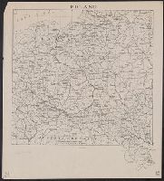
- Found in:
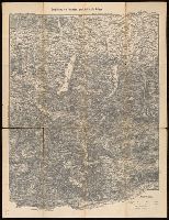
- Beinecke Rare Book and Manuscript Library > Poland.
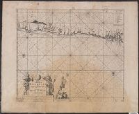
- Creator:
- Keulen, Johannes van, 1654-1715, cartographer.
- Call Number:
- 911 1695
- Image Count:
- 1
- Resource Type:
- Maps, Atlases & Globes
- Found in:
- Beinecke Rare Book and Manuscript Library > Pas-kaart van de zee-kusten van Brazilia, tusschen Cabo de Cuma, en Bahia Baxa [cartographic material] / Door C.J. Vooght, Geometra.
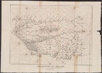
- Creator:
- Raleigh, Walter, Sir, 1552?-1618.
- Published / Created:
- 1892
- Call Number:
- 90475 1892
- Image Count:
- 1
- Resource Type:
- Maps, Atlases & Globes
- Found in:
- Beinecke Rare Book and Manuscript Library > Sir Walter Ralegh's karte von Guayana mit dem laug des Orinoco und des Maronon oder Amazonas um 1595 : Facsimile der im katalog des Britishen Museum unter Add. 17940 a aufgefuhrten manuscript-karte.
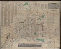
- Creator:
- Silas Farmer & Co.
- Published / Created:
- 1911-12 [i.e. 1911?], and c1911.
- Call Number:
- 811 D48 1911
- Container / Volume:
- BRBL_00553
- Image Count:
- 1
- Resource Type:
- Maps, Atlases & Globes
- Found in:
- Beinecke Rare Book and Manuscript Library > A new map of Detroit and suburbs : includes River Rouge, Oakwood, Highland Park, Hamtramck, St. Clair Heights, and Grosse Pointe.
- Creator:
- Scull, William, active 1765, cartographer.
- Published / Created:
- 10 June 1775.
- Call Number:
- 774 1775
- Container / Volume:
- BRBL_00497
- Image Count:
- 2
- Resource Type:
- Maps, Atlases & Globes
- Found in:
- Beinecke Rare Book and Manuscript Library > A map of Pennsylvania exhibiting not only the improved parts of that Province, but also its extensive frontiers: Laid down from actual surveys, and chiefly from the late map of W. Scull published in 1770; and humbly inscribed to the Honorable Thomas Penn
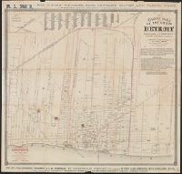
- Creator:
- Silas Farmer & Co.
- Published / Created:
- [1863]
- Call Number:
- 811 D48 1863
- Container / Volume:
- BRBL_00553
- Image Count:
- 2
- Resource Type:
- Maps, Atlases & Globes
- Found in:
- Beinecke Rare Book and Manuscript Library > Guide map of the city of Detroit / drawn by Eugene Robinson, city surveyor ; lith. by Ed Mendel.
- Creator:
- Pownall, Thomas, 1722-1805
- Published / Created:
- 12th May 1794.
- Call Number:
- 71 1794P
- Container / Volume:
- BRBL_00726
- Image Count:
- 2
- Resource Type:
- Maps, Atlases & Globes
- Found in:
- Beinecke Rare Book and Manuscript Library > A new map of North America with the West India Islands : divided according to the preliminary articles of peace, signed at Versailles, 20 Jan. 1783, wherein are particularly distinguished the United States, and the several provinces, governments &ca which
- Published / Created:
- [189x?]
- Call Number:
- Lanman Covers 56 189x
- Image Count:
- 2
- Resource Type:
- Maps, Atlases & Globes
- Found in:
- Beinecke Rare Book and Manuscript Library > [Map of China].
- Creator:
- Ptolemy, active 2nd century
- Published / Created:
- [1535]
- Call Number:
- Lanman 50 1535
- Collection Title:
- Claudii Ptolemaei Geographicae enarrationis libri octo.
- Image Count:
- 2
- Resource Type:
- Maps, Atlases & Globes
- Found in:
- Beinecke Rare Book and Manuscript Library > Tabvla svperioris Indiae & Tartariae maioris.
- Creator:
- Thomas Cook (Firm), cartographer.
- Published / Created:
- [1896]
- Call Number:
- BrSides Folio 2017 10
- Image Count:
- 2
- Resource Type:
- Maps, Atlases & Globes
- Found in:
- Beinecke Rare Book and Manuscript Library > Map of Cook's tours in Europe.
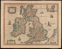
- Creator:
- Blaeu, Willem Janszoon, 1571-1638
- Call Number:
- Lanman 32 1648
- Image Count:
- 2
- Resource Type:
- Maps, Atlases & Globes
- Found in:
- Beinecke Rare Book and Manuscript Library > Magna Britanniae et hiberniae tabvla / Guiljelmus Blaeuw excudit.
- Published / Created:
- [1750?]
- Call Number:
- 615 32
- Container / Volume:
- BRBL_00332
- Image Count:
- 2
- Resource Type:
- Maps, Atlases & Globes
- Found in:
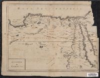
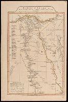
- Beinecke Rare Book and Manuscript Library > Aegyptus et Cyrenaica.
- Creator:
- Anville, Jean Baptiste Bourguignon d', 1697-1782, cartographer.
- Published / Created:
- 1719
- Call Number:
- 3945 1719
- Container / Volume:
- BRBL_00193
- Image Count:
- 2
- Resource Type:
- Maps, Atlases & Globes
- Found in:
- Beinecke Rare Book and Manuscript Library > Carte du royaume d'Aragon : dressée sur plursieurs cartes manuscrites et imprimees; sur les memoires composés dans le pays par M. l'Abbé de Vairac; sur les cartes topographiques des Pirenées levées sur les lieux par M. Roussel Ingenieur du Roy; confo
- Published / Created:
- c1886.
- Call Number:
- Zc35 886th
- Image Count:
- 2
- Resource Type:
- Maps, Atlases & Globes
- Found in:
- Beinecke Rare Book and Manuscript Library > Through northern Nebraska to the Black Hills : Elkhorn Valley Line : free homes for the 1,000,000 ...
- Creator:
- Speed, John, 1552?-1629
- Call Number:
- Lanman 50 1676
- Image Count:
- 2
- Resource Type:
- Maps, Atlases & Globes
- Found in:
- Beinecke Rare Book and Manuscript Library > A newe mape of Tartary / augmented by John Speed and are to be sold by Tho. Bassett in Fleet Street & Richard Chiswell in St. Pauls Churchyard ; Dirck Grÿp, sculp.
- Creator:
- Speed, John, 1552?-1629.
- Published / Created:
- [1676?]
- Call Number:
- 70 1676
- Container / Volume:
- BRBL_00354
- Image Count:
- 2
- Resource Type:
- Maps, Atlases & Globes
- Found in:
- Beinecke Rare Book and Manuscript Library > America with those known parts in that unknowne worlde both people and manner of buildings / Discribed and inlarged by I.S. Ano 1626 ; Abraham Goos ... sculpsit.
- Creator:
- Münster, Sebastian, 1489-1552.
- Published / Created:
- 1588]
- Call Number:
- 13 1588
- Image Count:
- 2
- Resource Type:
- Maps, Atlases & Globes
- Found in:
- Beinecke Rare Book and Manuscript Library > Ptolemeisch general Tafel : die halbe Kugel der Weltbegreiffende.
- Creator:
- Rice, G. Jay, cartographer.
- Published / Created:
- 1881
- Call Number:
- 821 1881A
- Image Count:
- 2
- Resource Type:
- Maps, Atlases & Globes
- Found in:
- Beinecke Rare Book and Manuscript Library > Rice's sectional map of Dakota
- Creator:
- Price & Lee Co., cartographer.
- Published / Created:
- 1917
- Call Number:
- BrSides Double Folio 2017 8
- Image Count:
- 2
- Resource Type:
- Maps, Atlases & Globes
- Found in:
- Beinecke Rare Book and Manuscript Library > The Price & Lee Co's. map of the city of New Haven, Connecticut / prepared by A.B. Hill, Civil Engineer.
- Creator:
- Sanson, Nicolas, 1600-1667, cartographer.
- Published / Created:
- [173-?]
- Call Number:
- 1973 Folio 18
- Image Count:
- 2
- Resource Type:
- Maps, Atlases & Globes
- Found in:
- Beinecke Rare Book and Manuscript Library > Le Royaume de France : distingué suivant l'estendue de toutes ses provinces et ses acquisitions, dans l'Espagne, dans l'Italie, dans l'Allemagne et dans les Pays Bas / par le Sr Sanson, géographe ordinaire du Roy, présenté au Roy par son très humble serviteur J. de Ram.
- Creator:
- Sanson, Nicolas, 1600-1667.
- Published / Created:
- [ca. 1700]
- Call Number:
- 1973 Folio 18
- Image Count:
- 2
- Resource Type:
- Maps, Atlases & Globes
- Found in:
- Beinecke Rare Book and Manuscript Library > Le cours de la riviere du Rhein [cartographic material] : depuis sa source jusques a son emboucheure, ou sont distingués toutes les estats et souverainetés qui sont dessus et aux environs / tiré de tous les Memoires les plus nouveaux par le Sr. Sanson ...
- Creator:
- Anville, Jean Baptiste Bourguignon d', 1697-1782
- Published / Created:
- 1st April 1812.
- Call Number:
- 61 1812B
- Image Count:
- 2
- Resource Type:
- Maps, Atlases & Globes
- Found in:
- Beinecke Rare Book and Manuscript Library > Aegyptus Antiqua Mandato Serenissimi Delphini publici juris facta / Auctor d'Anville Regiae Humaniorum Litterarum Academiae et scientiarum Petropolitanae socius, et Aurelianorum Celsiss. Duci a Secretis. MDCCLXV.
- Creator:
- Lapie, M. (Pierre), 1779-1850
- Published / Created:
- 1814
- Call Number:
- 49cea 1814
- Image Count:
- 2
- Resource Type:
- Maps, Atlases & Globes
- Found in:
- Beinecke Rare Book and Manuscript Library > Carte réduite de la Mer Méditerranée et de la Mer Noire / par P. Lapie ; gravée par P.A.F Tardieu ; écrit par J.J. Pachouse.
- Creator:
- Pioneer Abstract Co.
- Published / Created:
- Nov. 29, 1911
- Call Number:
- 833 C429 1911
- Container / Volume:
- BRBL_00584
- Image Count:
- 2
- Resource Type:
- Maps, Atlases & Globes
- Found in:
- Beinecke Rare Book and Manuscript Library > Map of city of Cheyenne and adjacent subdivisions / compiled by the Pioneer Abstract Co., Cheyenne, Wyo. from government, county, and other official records ; H.G. Porak, del. ; compliments of Mark A. Chapman, fire, insurance, and real estate.
- Creator:
- Artaria & Co., author.
- Published / Created:
- [between 1910 an 1919?]
- Call Number:
- 424 1910
- Container / Volume:
- BRBL_00245
- Image Count:
- 2
- Resource Type:
- Maps, Atlases & Globes
- Found in:
- Beinecke Rare Book and Manuscript Library > Artaria's neueste Touristen-karten im Massstabe von 1:129,600.
- Creator:
- Blaeu, Willem Janszoon, 1571-1638, cartographer.
- Published / Created:
- [1664]
- Call Number:
- 187 1664
- Container / Volume:
- BRBL_00013
- Image Count:
- 2
- Resource Type:
- Maps, Atlases & Globes
- Found in:
- Beinecke Rare Book and Manuscript Library > Nova Zemla.
- Creator:
- Blaeu, Willem Janszoon, 1571-1638, cartographer.
- Published / Created:
- [between 1643 and 1650]
- Call Number:
- BrSides Folio 2017 7
- Image Count:
- 2
- Resource Type:
- Maps, Atlases & Globes
- Found in:
- Beinecke Rare Book and Manuscript Library > Tartaria sive Magni Chami imperium.
- Creator:
- Colton, J. H. (Joseph Hutchins), 1800-1893, creator.
- Published / Created:
- [1855]
- Call Number:
- BrSides 2019 90
- Image Count:
- 2
- Resource Type:
- Maps, Atlases & Globes
- Found in:
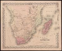
- Beinecke Rare Book and Manuscript Library > Colton's Africa : southern sheet.
- Published / Created:
- [between 1885 and 1900]
- Call Number:
- BrSides Box 2019 10
- Image Count:
- 2
- Resource Type:
- Maps, Atlases & Globes
- Found in:
- Beinecke Rare Book and Manuscript Library > West-Afrika.
- Creator:
- Hondius, Jodocus, 1563-1612, cartographer.
- Published / Created:
- [1625]
- Call Number:
- BrSides Box 2019 15
- Image Count:
- 2
- Resource Type:
- Maps, Atlases & Globes
- Found in:
- Beinecke Rare Book and Manuscript Library > Abissinorum Regnu[m].
- Creator:
- Price & Lee Co., cartographer.
- Published / Created:
- [1880?]
- Call Number:
- 766 N46 1880B
- Image Count:
- 2
- Resource Type:
- Maps, Atlases & Globes
- Found in:
- Beinecke Rare Book and Manuscript Library > Price, Lee & Co. new map of the City of New Haven / surveyed by S.W. Searle, surveyor and civil engineer and drawn by him expressly for their new city directory.
- Creator:
- Hondius, Jodocus, 1563-1612, cartographer.
- Published / Created:
- [1625]
- Call Number:
- BrSides Box 2019 14
- Image Count:
- 2
- Resource Type:
- Maps, Atlases & Globes
- Found in:
- Beinecke Rare Book and Manuscript Library > Iapan I [cartographic material].
- Creator:
- J.H. Colton & Co., cartographer.
- Published / Created:
- 1863
- Call Number:
- 754 1863A
- Image Count:
- 2
- Resource Type:
- Maps, Atlases & Globes
- Found in:
- Beinecke Rare Book and Manuscript Library > J.H. Colton's map of the Southern states : Maryland, Delaware, Virginia, Kentucky, Tennessee, Missouri, North Carolina, South Carolina, Georgia, Alabama, Mississippi, Arkansas, Louisiana, and Texas showing also part of adjoining states & territories locating the forts & military stations of the U. States & showing all the rail roads, R. R. stations, & other internal improvements / published by J.H. Colton.
- Creator:
- Scull, William, active 1765, cartographer.
- Published / Created:
- 10 June 1775.
- Call Number:
- 774 1775
- Container / Volume:
- BRBL_00730
- Image Count:
- 3
- Resource Type:
- Maps, Atlases & Globes
- Found in:
- Beinecke Rare Book and Manuscript Library > A map of Pennsylvania exhibiting not only the improved parts of that Province, but also its extensive frontiers: Laid down from actual surveys, and chiefly from the late map of W. Scull published in 1770; and humbly inscribed to the Honorable Thomas Penn
- Creator:
- Robert de Vaugondy, Gilles, 1688-1766.
- Published / Created:
- [1757-1786?]
- Call Number:
- 27 1750
- Container / Volume:
- BRBL_00023A
- Image Count:
- 1
- Resource Type:
- Maps, Atlases & Globes
- Found in:
- Beinecke Rare Book and Manuscript Library > Archipel des Indes Orientales : qui comprend les Isles de la Sonde, Moluques et Philippines / tirʹees des Cartes du Neptune Oriental par le Sr. Robert ; Guill. Delahaye sculp.
- Creator:
- Santini, Francesco, cartographer, publisher.
- Call Number:
- 23 1752C
- Image Count:
- 1
- Resource Type:
- Maps, Atlases & Globes
- Found in:
- Beinecke Rare Book and Manuscript Library > Carte des nouvelles découvertes au nord de la Mer du Sud : tant à l'est de la Siberie et du Kamtchatka, qu'à l'ouest de la Nouvelle France.
- Creator:
- Delarochette, L. (Louis), 1731-1802, cartographer.
- Call Number:
- 23 1794A
- Image Count:
- 1
- Resource Type:
- Maps, Atlases & Globes
- Found in:
- Beinecke Rare Book and Manuscript Library > Chart of the N.W. coast of America and the N.E. coast of Asia, explored in the years 1778 and 1779 / prepared by Lieut. Heny. Roberts, under the immediate inspection of Capt. Cook ; engraved by W. Palmer, No. 128, Chancery Lane.
- Creator:
- Imperatorskai︠a︡ akademīi︠a︡ nauk (Russia), cartographer, publisher.
- Call Number:
- 23 1773
- Image Count:
- 1
- Resource Type:
- Maps, Atlases & Globes
- Found in:
- Beinecke Rare Book and Manuscript Library > Nouvelle carte des decouvertes faites par les vaisseaux Russiens aux côtes inconnues de l'Amérique Septentrionale avec les pais adiacents / dressée sur des memoires authentiques de ceux qui ont assisté a ces decouvertes et sur d'autres connoissances.
- Published / Created:
- 1910?]
- Call Number:
- 11hcf 1919C-14
- Image Count:
- 1
- Resource Type:
- Maps, Atlases & Globes
- Found in:
- Beinecke Rare Book and Manuscript Library > Austria-Hungary.
- Published / Created:
- 191-]
- Call Number:
- 11hcf 1919E-32
- Image Count:
- 1
- Resource Type:
- Maps, Atlases & Globes
- Found in:
- Beinecke Rare Book and Manuscript Library > The Balkans.