Search
You Searched For
Search Results
- Creator:
- Cóvens et Mortier
- Published / Created:
- ca. 1730-ca. 1800]
- Call Number:
- 1973 Folio 71
- Image Count:
- 1
- Resource Type:
- Maps, Atlases & Globes
- Found in:
- Beinecke Rare Book and Manuscript Library > [Atlas nouveau contenant toutes les parties du monde ou sont exactement marqués les empires, monarchies, royaumes, états, republiques &c. Le tout recueilli par les meilleurs geógraphes.]
- Creator:
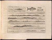
- Barbot, Jean, 1655-1712
Kip, Johannes, 1653-1722
- Published / Created:
- 1746
- Call Number:
- 1989 +19 5
- Collection Title:
- A collection of voyages and travels, some now first printed from original manuscripts, others now
- Image Count:
- 4
- Found in:
- Beinecke Rare Book and Manuscript Library > A description of the coasts of North and South Guinea : and of Ethiopia inferior, vulgarly Angola ... and a new relation of the province of Guiana, and of the great rivers of Amazons and Oronoque in South-America : with an appendix, being a general accoun
- Creator:
- Moll, Herman, d. 1732
- Published / Created:
- [178-?]
- Call Number:
- 1973 Folio 113
- Image Count:
- 2
- Resource Type:
- Maps, Atlases & Globes
- Found in:
- Beinecke Rare Book and Manuscript Library > Atlas minor: or A new and curious set of sixty two maps, in which are shewn all the empires, kingdoms, countries, states in all the known parts of the earth ... by Herman Moll ...
- Creator:
- Chauveau, François, 1613-1676
Jaillot, Alexis Hubert, 1632?-1712. Atlas nouveau
Sanson, Guillaume
- Published / Created:
- 1673
- Call Number:
- 1973 Folio 57
- Collection Title:
- Composite atlas of 41 maps from Alexis Hubert Jaillot's Atlas nouveau.
- Image Count:
- 1
- Found in:
- Beinecke Rare Book and Manuscript Library > Provinces-Unies des Pays-Bas : auec leurs acquisitions dans La Flandre, Le Brabant, Le Limbourg, et Le Lyege, et les places queílles possedoient sur le Rhein, dans le Ducheí de Cleves, et dans l'Archevescheí et Eslectorat de Cologne / par le Sr. Sanson
- Creator:
- Moll, Herman, d. 1732
- Published / Created:
- [1732]
- Call Number:
- E1015 M66 1732
- Image Count:
- 1
- Found in:
- Beinecke Rare Book and Manuscript Library > Atlas minor: or a set of sixty-two new and correct maps, of all parts of the world. All composed and done by Herman Moll, geographer ...
- Creator:
- Moll, Herman, d. 1732
- Published / Created:
- 17--]
- Call Number:
- 1978 47
- Collection Title:
- Atlas minor.
- Image Count:
- 1
- Found in:
- Beinecke Rare Book and Manuscript Library > The Island of St. Christophers By Her. Moll Geographer
- Creator:
- Moll, Herman, d. 1732
- Published / Created:
- [1732]
- Call Number:
- E1015 M66 1732
- Collection Title:
- Atlas minor: or a set of sixty-two new and correct maps, of all parts of the world. All composed
- Image Count:
- 1
- Found in:
- Beinecke Rare Book and Manuscript Library > The Island of St. Christophers, alias St. Kitts By H. Moll Geographer
- Call Number:
- 1977 +250
- Collection Title:
- Geografia; cioe, Descrittione vniversale della terra. Partita in due volumi, nel primo de’ quali si
- Image Count:
- 1
- Resource Type:
- Maps, Atlases & Globes
- Found in:
- Beinecke Rare Book and Manuscript Library > Descrittione dell'America, odell'India Occidentale. America
- Call Number:
- 1977 +250
- Collection Title:
- Geografia; cioe, Descrittione vniversale della terra. Partita in due volumi, nel primo de’ quali si
- Image Count:
- 1
- Resource Type:
- Maps, Atlases & Globes
- Found in:
- Beinecke Rare Book and Manuscript Library > Descrittione di tvtto'l mondo, secondo la prattica de Marinari. Vniversi orbis descriptio ad vsvm navigantivm
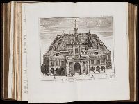
- Call Number:
- 1977 +392
- Collection Title:
- A survey of the cities of London and Westminster : containing the original, antiquity, increase
- Image Count:
- 1
- Resource Type:
- Maps, Atlases & Globes
- Found in:
- Beinecke Rare Book and Manuscript Library > Portsoken ward being part of the parish of St. Buttolphs Aldgate, taken from the last survey, with corrections and additions
- Call Number:
- 1977 +392
- Collection Title:
- A survey of the cities of London and Westminster : containing the original, antiquity, increase
- Image Count:
- 1
- Resource Type:
- Maps, Atlases & Globes
- Found in:
- Beinecke Rare Book and Manuscript Library > The Custom House
- Call Number:
- 1977 +392
- Collection Title:
- A survey of the cities of London and Westminster : containing the original, antiquity, increase
- Image Count:
- 1
- Resource Type:
- Maps, Atlases & Globes
- Found in:
- Beinecke Rare Book and Manuscript Library > Aldgate Ward with its division into parishes. Taken from the last survey, with corrections & additions
- Call Number:
- 1977 +392
- Collection Title:
- A survey of the cities of London and Westminster : containing the original, antiquity, increase
- Image Count:
- 1
- Resource Type:
- Maps, Atlases & Globes
- Found in:
- Beinecke Rare Book and Manuscript Library > Part of Aldgate Ward
- Call Number:
- 1977 +392
- Collection Title:
- A survey of the cities of London and Westminster : containing the original, antiquity, increase
- Image Count:
- 1
- Resource Type:
- Maps, Atlases & Globes
- Found in:
- Beinecke Rare Book and Manuscript Library > Bishop Gate Street Ward taken from the last survey and corrected
- Call Number:
- 1977 +392
- Collection Title:
- A survey of the cities of London and Westminster : containing the original, antiquity, increase
- Image Count:
- 1
- Resource Type:
- Maps, Atlases & Globes
- Found in:
- Beinecke Rare Book and Manuscript Library > Cornhill Ward with its division into parishes, taken from the last survey &c
- Call Number:
- 1977 +392
- Collection Title:
- A survey of the cities of London and Westminster : containing the original, antiquity, increase
- Image Count:
- 1
- Found in:
- Beinecke Rare Book and Manuscript Library > The Royal Exchange of London
- Call Number:
- 1977 +392
- Collection Title:
- A survey of the cities of London and Westminster : containing the original, antiquity, increase
- Image Count:
- 1
- Resource Type:
- Maps, Atlases & Globes
- Found in:
- Beinecke Rare Book and Manuscript Library > Candlewick Ward with its division into parishes. Corrected from the last survey
- Call Number:
- 1977 +392
- Collection Title:
- A survey of the cities of London and Westminster : containing the original, antiquity, increase
- Image Count:
- 1
- Resource Type:
- Maps, Atlases & Globes
- Found in:
- Beinecke Rare Book and Manuscript Library > Walbrook Ward and Dow Gate Ward with its division into parishes taken from the last surveys
- Call Number:
- 1977 +392
- Collection Title:
- A survey of the cities of London and Westminster : containing the original, antiquity, increase
- Image Count:
- 1
- Resource Type:
- Maps, Atlases & Globes
- Found in:
- Beinecke Rare Book and Manuscript Library > Queen Hith Ward and Vintry Ward with their division into parishes taken from the last surveys
- Call Number:
- 1977 +392
- Collection Title:
- A survey of the cities of London and Westminster : containing the original, antiquity, increase
- Image Count:
- 1
- Resource Type:
- Maps, Atlases & Globes
- Found in:
- Beinecke Rare Book and Manuscript Library > Bread Street Ward and Cordwainer Ward with it's division into parishes taken from the last survey
- Call Number:
- 1977 +392
- Collection Title:
- A survey of the cities of London and Westminster : containing the original, antiquity, increase
- Image Count:
- 1
- Resource Type:
- Maps, Atlases & Globes
- Found in:
- Beinecke Rare Book and Manuscript Library > Cheape Ward with its division into parishes, taken from the last survey, with corrections and additions
- Call Number:
- 1977 +392
- Collection Title:
- A survey of the cities of London and Westminster : containing the original, antiquity, increase
- Image Count:
- 1
- Found in:
- Beinecke Rare Book and Manuscript Library > The Prospect of Guild Hall
- Call Number:
- 1977 +392
- Collection Title:
- A survey of the cities of London and Westminster : containing the original, antiquity, increase
- Image Count:
- 1
- Resource Type:
- Maps, Atlases & Globes
- Found in:
- Beinecke Rare Book and Manuscript Library > Coleman Street Ward and Bashishaw Ward taken from the last survey, with corrections and additions
- Call Number:
- 1977 +392
- Collection Title:
- A survey of the cities of London and Westminster : containing the original, antiquity, increase
- Image Count:
- 1
- Resource Type:
- Maps, Atlases & Globes
- Found in:
- Beinecke Rare Book and Manuscript Library > The Wards of Farington within and Baynards Castle with its divisions into parishes taken from the last survey with corrections
- Call Number:
- 1977 +392
- Collection Title:
- A survey of the cities of London and Westminster : containing the original, antiquity, increase
- Image Count:
- 1
- Resource Type:
- Maps, Atlases & Globes
- Found in:
- Beinecke Rare Book and Manuscript Library > Farington Ward without, with its divisions into parishes, taken from the last survey with corrections & amendments
- Call Number:
- 1977 +392
- Collection Title:
- A survey of the cities of London and Westminster : containing the original, antiquity, increase
- Image Count:
- 1
- Resource Type:
- Maps, Atlases & Globes
- Found in:
- Beinecke Rare Book and Manuscript Library > St. Olave and St. Mary Magdalen Bermondsey Southwark, taken from the last survey with corrections
- Call Number:
- 1977 +392
- Collection Title:
- A survey of the cities of London and Westminster : containing the original, antiquity, increase
- Image Count:
- 1
- Resource Type:
- Maps, Atlases & Globes
- Found in:
- Beinecke Rare Book and Manuscript Library > A mapp of the parishes of St. Saviours Southwark and St. Georges taken from the last survey with corrections
- Call Number:
- 1977 +392
- Collection Title:
- A survey of the cities of London and Westminster : containing the original, antiquity, increase
- Image Count:
- 1
- Resource Type:
- Maps, Atlases & Globes
- Found in:
- Beinecke Rare Book and Manuscript Library > A map of the parish if St. Katherines by the Tower
- Call Number:
- 1977 +392
- Collection Title:
- A survey of the cities of London and Westminster : containing the original, antiquity, increase
- Image Count:
- 1
- Resource Type:
- Maps, Atlases & Globes
- Found in:
- Beinecke Rare Book and Manuscript Library > The parish of St. Johns Wapping
- Call Number:
- 1977 +392
- Collection Title:
- A survey of the cities of London and Westminster : containing the original, antiquity, increase
- Image Count:
- 1
- Resource Type:
- Maps, Atlases & Globes
- Found in:
- Beinecke Rare Book and Manuscript Library > A map of the parish of St. Dustans Stepney and Stebunheath divided into hamlets
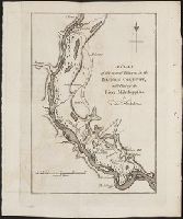
- Call Number:
- Zc20 697heg
- Collection Title:
- A new discovery of a vast country in America : extending above four thousand miles, between New
- Image Count:
- 1
- Found in:
- Beinecke Rare Book and Manuscript Library > A map of a large country newly discovered in the northern America situated between New Mexico and the frozen sea, together with the course of the Great River Meschasipi. Dedicated to His Ma.ty William III King of Great Britain. By Father Lewis Hennepin, m
- Published / Created:
- 1793
- Call Number:
- CF352 I54 1793
- Collection Title:
- The discovery, settlement, and present state of Kentucky: and an essay towards the topography and
- Image Count:
- 1
- Found in:
- Beinecke Rare Book and Manuscript Library > A map of the state of Kentucky, drawn from the best authorities
- Creator:
- Jefferys, Thomas, d. 1771
- Call Number:
- Z6 70
- Collection Title:
- An enquiry into the causes of the alienation of the Delaware and Shawanese Indians from the British
- Image Count:
- 1
- Found in:
- Beinecke Rare Book and Manuscript Library > A map of the province of Pensylvania. intended chiefly to illustrate the account of the several Indian purchases made by the proprietaries of the said province the claims made by the Indians, on lands settled and not purchased of them and the tract they n
- Call Number:
- Egf 778Hb
- Collection Title:
- A topographical description of Virginia, Pennsylvania, Maryland and North Carolina : comprehending
- Image Count:
- 1
- Found in:
- Beinecke Rare Book and Manuscript Library > A plan of the several villages in the Illinois country, with part of the river Mississippi &c. by Thos. Hutchins
- Call Number:
- Pequot Ad12
- Collection Title:
- The history of the American Indians; particularly those nations adjoining to the Missisippi
- Image Count:
- 1
- Found in:
- Beinecke Rare Book and Manuscript Library > A map of the American Indian nations, adjoining to the Missisippi, west & east Florida, Georgia, S. & N. Carolina, Virginia, & c
- Call Number:
- C55 025
- Collection Title:
- Voyages and travels of an Indian interpreter and trader, describing the manners and customs of the
- Image Count:
- 1
- Found in:
- Beinecke Rare Book and Manuscript Library > Sketch of the western countries of Canada 1791
- Creator:
- Hole, William, d. 1624, engraver
- Published / Created:
- [ca. 1606]
- Call Number:
- Taylor 301
- Collection Title:
- The generall historie of Virginia, New-England, and the Summer Iles : with the names of the
- Image Count:
- 1
- Found in:
- Beinecke Rare Book and Manuscript Library > Virginia
- Published / Created:
- 1783
- Call Number:
- Cb21 35B
- Collection Title:
- History of the war with America, France, Spain, and Holland; commencing in 1775 and ending in 1783
- Image Count:
- 1
- Found in:
- Beinecke Rare Book and Manuscript Library > A Map of the United States of America, as settled by the peace of 1783
- Creator:
- Lescarbot, Marc
- Published / Created:
- [1609]
- Call Number:
- Taylor 245
- Collection Title:
- Histoire de la Novvelle France
- Image Count:
- 1
- Found in:
- Beinecke Rare Book and Manuscript Library > Figure de la terre neuue, grande riuiere de Canada, et cotes de l�ocean en la Nouuelle France
- Creator:
- Lescarbot, Marc
- Published / Created:
- 1609
- Call Number:
- Taylor 245
- Collection Title:
- Histoire de la Novvelle France
- Image Count:
- 1
- Found in:
- Beinecke Rare Book and Manuscript Library > Figure du Port Royal en la Nouuelle France
- Published / Created:
- Undated
- Call Number:
- Ck44 23
- Collection Title:
- Kort beskrifning om provincien Nya Swerige uti America : som nu foertjden af the Engelske kallas
- Image Count:
- 1
- Found in:
- Beinecke Rare Book and Manuscript Library > Totius Americae descriptio
- Call Number:
- Ck44 23
- Collection Title:
- Kort beskrifning om provincien Nya Swerige uti America : som nu foertjden af the Engelske kallas
- Image Count:
- 1
- Found in:
- Beinecke Rare Book and Manuscript Library > Nova Suecia hodie dicta Pensylvania
- Call Number:
- Ck44 23
- Collection Title:
- Kort beskrifning om provincien Nya Swerige uti America : som nu foertjden af the Engelske kallas
- Image Count:
- 1
- Found in:
- Beinecke Rare Book and Manuscript Library > Virginiae N. Angliae N. Hollandiae nec non Nova Sueviae delineatio
- Call Number:
- Cm87 48th
- Collection Title:
- Histoire de Kentucke : nouvelle colonie a l'ouest de al Virginie: contenant, 1o, La decouverte
- Image Count:
- 1
- Found in:
- Beinecke Rare Book and Manuscript Library > Carte de Kentucke, d'apres les observations actuelles: dediee a L'Honorable Congres des Etats-Unis de l'Amerique et a Son Excellence George Washington, Commandant en chef de ses armees par leur tres humble serviteur, John Filson
- Call Number:
- Taylor 376
- Collection Title:
- The discoveries of John Lederer : in three several marches from Virginia, to the west of Carolina
- Image Count:
- 1
- Found in:
- Beinecke Rare Book and Manuscript Library > A Map of the whole territory traversed by John Lederer in his three marches
- Creator:
- Tiebout, Cornelius, 1777-1832
- Call Number:
- CF352 I54 1793
- Collection Title:
- A topographical description of the Western territory of North America; containing a succinct
- Image Count:
- 1
- Found in:
- Beinecke Rare Book and Manuscript Library > New map of the states of Georgia South and North Carolina Virginia and Maryland including the Spanish provinces of west and east Florida from the latest surveys
- Call Number:
- CF352 I54 1793
- Collection Title:
- A topographical description of the Western territory of North America; containing a succinct
- Image Count:
- 1
- Found in:
- Beinecke Rare Book and Manuscript Library > A plan of the rapids of the Ohio
- Creator:
- Hall, Sidney
- Published / Created:
- 1822 March
- Call Number:
- Egk30 Ed9 820W
- Collection Title:
- Two years' residence in the settlement on the English prairie, in the Illinois country ... : with
- Image Count:
- 1
- Found in:
- Beinecke Rare Book and Manuscript Library > Map of Illinois
- Creator:
- Hall, Sidney
- Published / Created:
- 1822 March
- Call Number:
- Egk30 Ed9 820W
- Collection Title:
- Two years' residence in the settlement on the English prairie, in the Illinois country ... : with
- Image Count:
- 1
- Found in:
- Beinecke Rare Book and Manuscript Library > Map of the allotments
- Creator:
- Cardano, Jose Maria
Morata, Antonio?
- Call Number:
- Zc70 +802ea
- Collection Title:
- Relacion del viage hecho por las goletas Sutil y Mexicana en el ano de 1792, para reconocer el
- Image Count:
- 1
- Found in:
- Beinecke Rare Book and Manuscript Library > Carta esferica de los reconocimientos hechos en la costa N.O. de America en 1791 y 92 por las goletas Sutil y Mexicana y otros buques de S.M. Map No. 1
- Creator:
- Cardano, Jose Maria
- Call Number:
- Zc70 +802ea
- Collection Title:
- Relacion del viage hecho por las goletas Sutil y Mexicana en el ano de 1792, para reconocer el
- Image Count:
- 1
- Found in:
- Beinecke Rare Book and Manuscript Library > Carta esferica de los reconocimientos hechos en la costa N.O. de America en 1791 y 92 por las goletas Sutil y Mexicana y otros buques de S.M. Map no. 2
- Creator:
- Cardano, Jose Maria
Morata, Antonio?
- Call Number:
- Zc70 +802ea
- Collection Title:
- Relacion del viage hecho por las goletas Sutil y Mexicana en el ano de 1792, para reconocer el
- Image Count:
- 1
- Found in:
- Beinecke Rare Book and Manuscript Library > Contiuacion de los reconocimientos hechos en la costa NO. de America por los buques de S.M. en varias campanas desde 1774 a 1792. Map no. 3
- Creator:
- Cardano, Jose Maria
Morata, Antonio?
- Call Number:
- Zc70 +802ea
- Collection Title:
- Relacion del viage hecho por las goletas Sutil y Mexicana en el ano de 1792, para reconocer el
- Image Count:
- 1
- Found in:
- Beinecke Rare Book and Manuscript Library > Plano del puerto de S. Diego en la costa setentl. de Californs. Levantado por el 2o. piloto de la armada D. Juan Pantoja ano 1782. Map no. 5
- Creator:
- Cardano, Jose Maria
Morata, Antonio?
- Call Number:
- Zc70 +802ea
- Collection Title:
- Relacion del viage hecho por las goletas Sutil y Mexicana en el ano de 1792, para reconocer el
- Image Count:
- 1
- Found in:
- Beinecke Rare Book and Manuscript Library > Plano del puerto y bahia de Monte Rey situado en la costa de Californs. Trabajado a bordo de las corvetas descubierta y atrevida. Ano 1791. Map no. 6
- Creator:
- Vaughan, Robert, 17th cent., engraver
- Published / Created:
- 1624
- Call Number:
- 2003 +39
- Collection Title:
- The generall historie of Virginia, New-England, and the Summer Iles ...
- Image Count:
- 1
- Found in:
- Beinecke Rare Book and Manuscript Library > A description of part of the adventures of Cap. Smith in Virginia
- Creator:
- Russell, John, fl. 1733-1795
- Published / Created:
- 1794 July 26
- Call Number:
- 1986 102
- Collection Title:
- An historical, geographical, commercial, and philosophical view of the American United States, and
- Image Count:
- 1
- Found in:
- Beinecke Rare Book and Manuscript Library > A General map of North America drawn from the best sources
- Creator:
- Russell, John, fl. 1733-1795
- Published / Created:
- 1794 October 18
- Call Number:
- 1986 102
- Collection Title:
- An historical, geographical, commercial, and philosophical view of the American United States, and
- Image Count:
- 1
- Found in:
- Beinecke Rare Book and Manuscript Library > An Accurate map of the United States of America. according to the Treaty of Peace of 1783
- Creator:
- Russell, John, fl. 1733-1795
- Published / Created:
- 1795 February 7
- Call Number:
- 1986 102
- Collection Title:
- An historical, geographical, commercial, and philosophical view of the American United States, and
- Image Count:
- 1
- Found in:
- Beinecke Rare Book and Manuscript Library > Map of the northern, or, New England states of America. Comprehending Vermont, New Hampshire, District of Main, Massachusetts, Rhode-Island, and Connecticut
- Creator:
- Doolittle, Amos, 1754-1832
Purcell, Joseph
- Published / Created:
- 1788
- Call Number:
- Egf 789
- Collection Title:
- The American geography; or, A view of the present situation of the United States of America
- Image Count:
- 1
- Found in:
- Beinecke Rare Book and Manuscript Library > A Map of the states of Virginia, North Carolina South Carolina and Georgia comprehending the Spanish provinces of east and west Florida exhibiting the boundaries as fixed by the late Treaty of Peace between the United States and the Spanish dominions comp
- Call Number:
- Egf 789
- Collection Title:
- The American geography; or, A view of the present situation of the United States of America
- Image Count:
- 1
- Found in:
- Beinecke Rare Book and Manuscript Library > A Map of the northern and middle states; comprehending the western Territory and the British dominions in North America. Compiled from the best authorities
- Creator:
- Moll, Herman, d. 1732
- Published / Created:
- [1732]
- Call Number:
- E1015 M66 1732
- Collection Title:
- Atlas minor: or a set of sixty-two new and correct maps, of all parts of the world. All composed
- Image Count:
- 1
- Found in:
- Beinecke Rare Book and Manuscript Library > A new map of the whole world with the trade winds according to ye latest and most exact observations by H. Moll geographer.
- Creator:
- Moll, Herman, d. 1732
- Published / Created:
- [1732]
- Call Number:
- E1015 M66 1732
- Collection Title:
- Atlas minor: or a set of sixty-two new and correct maps, of all parts of the world. All composed
- Image Count:
- 1
- Found in:
- Beinecke Rare Book and Manuscript Library > A new map of ye north parts of America claimed by France under ye names of Louisiana. Mississipi, Canada & New France, with the adjoyning territories of England & Spain. By H. Moll geographer.
- Creator:
- Moll, Herman, d. 1732
- Published / Created:
- [1732]
- Call Number:
- E1015 M66 1732
- Collection Title:
- Atlas minor: or a set of sixty-two new and correct maps, of all parts of the world. All composed
- Image Count:
- 1
- Found in:
- Beinecke Rare Book and Manuscript Library > New Foundland St. Laurence Bay, the fishing banks, Acadia, and part of New Scotland. By H. Moll geographer.
- Creator:
- Moll, Herman, d. 1732
- Published / Created:
- [1732]
- Call Number:
- E1015 M66 1732
- Collection Title:
- Atlas minor: or a set of sixty-two new and correct maps, of all parts of the world. All composed
- Image Count:
- 1
- Found in:
- Beinecke Rare Book and Manuscript Library > New England, New York, New Jersey and Pensilvania. By H. Moll geographer.
- Creator:
- Moll, Herman, d. 1732
- Published / Created:
- [1732]
- Call Number:
- E1015 M66 1732
- Collection Title:
- Atlas minor: or a set of sixty-two new and correct maps, of all parts of the world. All composed
- Image Count:
- 1
- Found in:
- Beinecke Rare Book and Manuscript Library > Virginia and Maryland by H. Moll geographer.
- Creator:
- Moll, Herman, d. 1732
- Published / Created:
- [1732]
- Call Number:
- E1015 M66 1732
- Collection Title:
- Atlas minor: or a set of sixty-two new and correct maps, of all parts of the world. All composed
- Image Count:
- 1
- Found in:
- Beinecke Rare Book and Manuscript Library > Carolina by H. Moll geographer.
- Creator:
- Moll, Herman, d. 1732
- Published / Created:
- [1732]
- Call Number:
- E1015 M66 1732
- Collection Title:
- Atlas minor: or a set of sixty-two new and correct maps, of all parts of the world. All composed
- Image Count:
- 1
- Found in:
- Beinecke Rare Book and Manuscript Library > Florida called by ye French Louisiana & c. By H. Moll geographer.
- Creator:
- Moll, Herman, d. 1732
- Published / Created:
- [1732]
- Call Number:
- E1015 M66 1732
- Collection Title:
- Atlas minor: or a set of sixty-two new and correct maps, of all parts of the world. All composed
- Image Count:
- 1
- Found in:
- Beinecke Rare Book and Manuscript Library > A map of the West-Indies & c. Mexico or New Spain. Also ye trade winds, and ye several tracts made by ye galeons and flota from place to place. By H. Moll geographer.
- Call Number:
- EEg 671P
- Collection Title:
- America: being the latest, and most accurate description of the New world; containing the original
- Image Count:
- 1
- Found in:
- Beinecke Rare Book and Manuscript Library > Nova Virginiae Tabula
- Creator:
- Moxon, J. (James)
- Call Number:
- EEg 671P
- Collection Title:
- America: being the latest, and most accurate description of the New world; containing the original
- Image Count:
- 1
- Found in:
- Beinecke Rare Book and Manuscript Library > A new discription of Carolina by order of the Lords proprietors
- Creator:
- Parker, Samuel, 1779-1866
Peabody, M. M. (Moody Morse), 1789-1866
- Published / Created:
- 1838
- Call Number:
- Zc74 Or4
- Collection Title:
- The Oregonian, and Indian's advocate
- Image Count:
- 1
- Found in:
- Beinecke Rare Book and Manuscript Library > Map of Oregon Territory
- Creator:
- Kemble, William
- Call Number:
- Zc52 844keb
- Collection Title:
- Narrative of the Texan Santa Fe expedition. Comprising a description of a tour through Texas, and
- Image Count:
- 1
- Found in:
- Beinecke Rare Book and Manuscript Library > Texas and part of Mexico & the United States, showing the route of the first Santa Fe expedition
- Call Number:
- 2003 +109
- Collection Title:
- Die unbekante Neue Welt/ oder Beschreibung des wel-teils Amerika, und des Sud-landes: darinnen vom
- Image Count:
- 1
- Found in:
- Beinecke Rare Book and Manuscript Library > Novi Belgii Quod nunc Novi Jorck vocatur, Novae q. Angliae, & partis Virginiae aAccuratissima et novissima delineatio
- Call Number:
- Taylor 192 1-3
- Collection Title:
- Brevis narratio eorvm qvae in Florida Americae provicia Gallis acciderunt, secunda in illam
- Container / Volume:
- Pt. 2
- Image Count:
- 1
- Found in:
- Beinecke Rare Book and Manuscript Library > Floridae Americae Provinciae
- Creator:
- Bry, Theodor de, 1528-1598
- Published / Created:
- MDXCIIII [1594]
- Call Number:
- Taylor 192 4-6
- Collection Title:
- Americae pars quarta, sive, Insignis & admiranda historia de reperta primum Occidentali India a
- Image Count:
- 1
- Found in:
- Beinecke Rare Book and Manuscript Library > Occidentalis Americae partis, vel earum regionum quas Christophorus Columbus primu[m] detexit ... praesertim vero ex Hieronymi Benzoni (qui totis XIIII annis eas provincias diligenter perlustravit) historia, conflata & in aes incisa a Theodoro de Bry Leod
- Call Number:
- Taylor 192 4-6
- Collection Title:
- Americae pars quinta nobilis & admiratione plena Hieronymi Bezoni Mediolanensis secundae sectionis
- Image Count:
- 1
- Found in:
- Beinecke Rare Book and Manuscript Library > Hispaniae Novae Sive Magnae, Recens et Vera Descriptio 1595
- Call Number:
- Taylor 192 4-6
- Collection Title:
- Americae pars sexta, sive, Historiae ab Hieronymo Be[n]zono Mediolane[n]se scriptae, sectio tertia
- Image Count:
- 1
- Found in:
- Beinecke Rare Book and Manuscript Library > America Sive Novus Orbis Respectu Europaeorum Inferior Globe Terrestris Pars 1596
- Call Number:
- Taylor 192 13
- Collection Title:
- Decima tertia pars historiae Americanae, qvae continet exactam et accvratam descriptionem I. Novae
- Image Count:
- 1
- Found in:
- Beinecke Rare Book and Manuscript Library > American nouiter delineata
- Creator:
- Tanner, Henry Schenck, 1786-1858
- Published / Created:
- 1822
- Call Number:
- 2003 Folio 81
- Collection Title:
- The New American Atlas ...
- Container / Volume:
- No. IV [4]
- Image Count:
- 1
- Found in:
- Beinecke Rare Book and Manuscript Library > A Map of North America, Constructed According to the Latest Information by H. S. Tanner
- Creator:
- Bry, Theodor de, 1528-1598
Hariot, Thomas, 1560-1621
- Published / Created:
- 1590
- Call Number:
- Taylor 194
- Image Count:
- 71
- Found in:
- Beinecke Rare Book and Manuscript Library > A briefe and true report of the new found land of Virginia: of the commodities and of the nature and manners of the naturall inhabitants. Discouered by the English colony there seated by Sir Richard Greinuile ... in ... 1585 ... This fore booke is made in
- Creator:
- Langren, Arnold Florent van, 1580-1644
- Published / Created:
- [1596?]
- Call Number:
- Z3 017
- Collection Title:
- ... Iohn Hvighen van Linschoten. his Discours of Voyages into ye Easte & West Indies. Deuided into
- Image Count:
- 1
- Found in:
- Beinecke Rare Book and Manuscript Library > Typus orarum maritimarum Guineae, Manicongo & Angolae ultra promontorium Bonae Spei ...
- Creator:
- Bry, Theodor de, 1528-1598
- Call Number:
- 1976 Folio 110
- Collection Title:
- The mariners mirrovr wherin may playnly be seen the courses, heights, distances, depths, sounding
- Image Count:
- 1
- Resource Type:
- Maps, Atlases & Globes
- Found in:
- Beinecke Rare Book and Manuscript Library > The sea coastes of the landes of Poyctou and Bordeaux ...as they shew and appeare, when you sayle there alongst betweene Picquelier and the River of Bordeaux called the Garonne
- Creator:
- Clark, William, 1770-1838
Lewis, Samuel, 1753 or 4-1822
- Published / Created:
- [ca. 1814]
- Call Number:
- Zc10 814Le
- Collection Title:
- History of the expedition under the command of Captains Lewis and Clark, to the sources of the
- Image Count:
- 2
- Resource Type:
- Maps, Atlases & Globes
- Found in:
- Beinecke Rare Book and Manuscript Library > A map of Lewis and Clark's track, across the western portion of North America fom the Mississippi to the Pacific Ocean; by order of the Executive of the United States . In 1804, 5 & 6
- Creator:
- Moll, Herman, d. 1732
- Published / Created:
- [1732]
- Call Number:
- E1015 M66 1732
- Collection Title:
- Atlas minor: or a set of sixty-two new and correct maps, of all parts of the world. All composed
- Image Count:
- 1
- Found in:
- Beinecke Rare Book and Manuscript Library > A description of the Bay of Fundy showing ye coast, islands, harbours, creeks, coves, rocks, sholes, soundings & anchorings &c... Observed by Nat. Blackmore in ye yeare 1711 and 1712 ...
- Creator:
- Manley, Roger, Sir, 1626?-1688
- Published / Created:
- 1683
- Call Number:
- DL192 M35 1683+ Oversize
- Image Count:
- 91
- Found in:
- Beinecke Rare Book and Manuscript Library > The history of the late wars in Denmark : comprising, all the transactions, both military and civil ... in the years, 1657, 1658, 1659, 1660 ... / by Sir Roger Manley
- Call Number:
- Mexico Ct +h780cg
- Collection Title:
- The history of Mexico. Collected from Spanish and Mexican historians, from manuscripts and ancient
- Image Count:
- 27
- Found in:
- Beinecke Rare Book and Manuscript Library > The history of Mexico. Collected from Spanish and Mexican historians, from manuscripts and ancient paintings of the Indians ...
- Call Number:
- Mexico Ct +h780cg
- Collection Title:
- The history of Mexico. Collected from Spanish and Mexican historians, from manuscripts and ancient
- Image Count:
- 3
- Found in:
- Beinecke Rare Book and Manuscript Library > The history of Mexico. Collected from Spanish and Mexican historians, from manuscripts and ancient paintings of the Indians ...
- Call Number:
- 1977 +250
- Collection Title:
- Geografia; cioe, Descrittione vniversale della terra. Partita in due volumi, nel primo de’ quali si
- Image Count:
- 1
- Found in:
- Beinecke Rare Book and Manuscript Library > Descrittione del potentissimo imperio della Tartaria
- Call Number:
- 1983 Folio 44
- Collection Title:
- Isolario : descrittione geografico-historica, sacro-profana, antico-moderna, politica, naturale, e
- Image Count:
- 2
- Resource Type:
- Books, Journals & Pamphlets
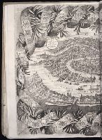
- Found in:
- Beinecke Rare Book and Manuscript Library > Citta di Venetia, descritta dal P. Coronelli, cosmografio della serenissima republica
- Call Number:
- 1983 Folio 44
- Collection Title:
- Isolario : descrittione geografico-historica, sacro-profana, antico-moderna, politica, naturale, e
- Image Count:
- 3
- Resource Type:
- Books, Journals & Pamphlets
- Found in:
- Beinecke Rare Book and Manuscript Library > [Selected pages]
- Creator:
- Neele, Samuel John, 1758-1824
- Published / Created:
- 1798
- Call Number:
- Egf +759c
- Collection Title:
- Travels through the middle settlements in North America, : in the years 1759 and 1760; with
- Image Count:
- 1
- Resource Type:
- Books, Journals & Pamphlets
- Found in:
- Beinecke Rare Book and Manuscript Library > Map of Dr. Burnaby's travels through the middle settlements of North America
- Creator:
- Seller, John, fl. 1658-1698
- Published / Created:
- [1677?]
- Call Number:
- 1973 Folio 63
- Image Count:
- 57
- Found in:
- Beinecke Rare Book and Manuscript Library > The coasting pilot: describing the sea-coasts, channels, soundings, sands, shoals, rocks, & dangers ... upon the coasts of England,Holland, Flanders & France ... Being furnished with new draughts, charts, and descriptions, gathered from ... diverse able a
- Creator:
- Boehme, August Gottlieb, 1719-1797
Hase, Johann Matthias, 1684-1742
Homann Erben (Firm)
- Published / Created:
- MDCCXXXXVI [i.e., 1759]
- Call Number:
- 1983 Folio 23
- Collection Title:
- [Atlas factice of 50 maps, primarily by Johann Baptist Homann and/or issued by the Homann Erben
- Image Count:
- 1
- Found in:
- Beinecke Rare Book and Manuscript Library > Americae mappa generalis : secundum legitimas projectionis stereographicae regulas, relationesque recentissimas et observationes sociorum Acad. reg. sc. quae Parisiis est aliorumque auctorum nec non secundum mentem D.I.M. Hasii ; M.P.P. in partes suas met
- Creator:
- Homann, Johann Baptist, 1663-1724
- Published / Created:
- [ca. 1715]
- Call Number:
- 1983 Folio 23
- Collection Title:
- [Atlas factice of 50 maps, primarily by Johann Baptist Homann and/or issued by the Homann Erben
- Image Count:
- 1
- Found in:
- Beinecke Rare Book and Manuscript Library > Tabula Ducatus Carnioliae, vindorum Marchiae et Histriae et mente Mustr. quondam J.B. Valvasorii / concinnatia et exhibita a Io. Bapt. Homanno, S.C.M. Geogr
- Creator:
- Guessefeld, F. L. (Franz Ludwig), 1744-1807
Homann Erben (Firm)
- Published / Created:
- 1775
- Call Number:
- 1983 Folio 23
- Collection Title:
- [Atlas factice of 50 maps, primarily by Johann Baptist Homann and/or issued by the Homann Erben
- Image Count:
- 1
- Found in:
- Beinecke Rare Book and Manuscript Library > Lubomeriae et Galliciae regni tabula geographica / [cartographic material] / F.I.G
- Creator:
- Homann Erben (Firm)
Mayer, Tobias, 1723-1762
- Published / Created:
- 1773
- Call Number:
- 1983 Folio 23
- Collection Title:
- [Atlas factice of 50 maps, primarily by Johann Baptist Homann and/or issued by the Homann Erben
- Image Count:
- 1
- Found in:
- Beinecke Rare Book and Manuscript Library > Mappa geographica Regni Poloniae [cartographic material] : ex novissimis quotquot sunt mappis specialibus composita et ad L.L. stereographicae projectionis / revocata a Tob. Mayero, S.C.S.
- Creator:
- Guessefeld, F. L. (Franz Ludwig), 1744-1807
Homann Erben (Firm)
Lopez, D. T.
- Published / Created:
- MDCCLXXXII [1782]
- Call Number:
- 1983 Folio 23
- Collection Title:
- [Atlas factice of 50 maps, primarily by Johann Baptist Homann and/or issued by the Homann Erben
- Image Count:
- 1
- Found in:
- Beinecke Rare Book and Manuscript Library > Regnorum Hispaniae et Portugalliae [cartographic material] : tabula generalis ad statum hodiernum in suas provincias / divisa per D.T. Lopez ; in nonnullis emendavit F.L. Guessefeld
- Creator:
- Gussefeld, F. L. (Franz Ludwig), 1744-1807
Homann Erben (Firm)
Schmidt, I. M.
- Published / Created:
- ao. 1784
- Call Number:
- 1983 Folio 23
- Collection Title:
- [Atlas factice of 50 maps, primarily by Johann Baptist Homann and/or issued by the Homann Erben
- Image Count:
- 1
- Found in:
- Beinecke Rare Book and Manuscript Library > Charte ueber die XIII vereinigte Staaten von Nord-Amerika / [cartographic material] / entworfen durch F.L. Guessefeld ; und herausgegeben von den Homaennischen Erben
- Creator:
- Homann Erben (Firm)
- Published / Created:
- 1784
- Call Number:
- 1983 Folio 23
- Collection Title:
- [Atlas factice of 50 maps, primarily by Johann Baptist Homann and/or issued by the Homann Erben
- Image Count:
- 1
- Found in:
- Beinecke Rare Book and Manuscript Library > Neue Welt-Karte welch auf zwoo Klugelflaechen die Haupt-Theile der Erde, Inseln, Insel-Gruppen, Theile des Welt-Meers und der en Benennungen den fuensten Welt-theil und die neuesten Entdekkungen nach den Karten und Reisebeschreibungen der beruehmtesten Se
- Creator:
- Hase, Johann Matthias, 1684-1742
Homann Erben (Firm)
- Published / Created:
- [1743?]
- Call Number:
- 1983 Folio 23
- Collection Title:
- [Atlas factice of 50 maps, primarily by Johann Baptist Homann and/or issued by the Homann Erben
- Image Count:
- 1
- Found in:
- Beinecke Rare Book and Manuscript Library > Europa, secundum legitimas projectionis stereographicae regulas [cartographic material] : et juxta recentissimas observationes aeque ac relationes adhibitis quoq[ue] veterum monumentorum subsidiis / descripta et in partes suas methodicas X divisa a Ioh. M