Search
You Searched For
Search Results
- Creator:
- Sarony & Major
- Call Number:
- A52 030 1
- Collection Title:
- Ancient monuments of the Mississippi Valley: comprising the results of extensive original surveys
- Image Count:
- 1
- Found in:
- Beinecke Rare Book and Manuscript Library > "The serpent;" (Entry 1014) Adams County Ohio. Pl. XXXV [35]
- Published / Created:
- 1850
- Call Number:
- 1976 Folio 96
- Collection Title:
- A new universal atlas containing maps of the various empires, kingdoms, states and republics of the
- Image Count:
- 1
- Resource Type:
- Maps, Atlases & Globes
- Found in:
- Beinecke Rare Book and Manuscript Library > 10. Map of Connecticut
- Creator:
- Erdoes, Richard, 1912-2008
- Published / Created:
- 1976-1983, undated
- Call Number:
- WA MSS S-2609
- Collection Title:
- Richard Erdoes papers
- Container / Volume:
- Box 46 | Plains Indian History II
- Image Count:
- 40
- Found in:
- Beinecke Rare Book and Manuscript Library > 18th Century Maps
- Published / Created:
- 1846
- Call Number:
- 1976 Folio 93
- Collection Title:
- A new universal atlas containing maps of the various empires, kingdoms, states and republics of the
- Image Count:
- 1
- Resource Type:
- Maps, Atlases & Globes
- Found in:
- Beinecke Rare Book and Manuscript Library > 9. Connecticut
- Creator:
- Russell, John, fl. 1733-1795
- Published / Created:
- 1794 July 26
- Call Number:
- 1986 102
- Collection Title:
- An historical, geographical, commercial, and philosophical view of the American United States, and
- Image Count:
- 1
- Found in:
- Beinecke Rare Book and Manuscript Library > A General map of North America drawn from the best sources
- Creator:
- Hutchins, Thomas, 1730-1789
- Call Number:
- Vanderbilt 147
- Collection Title:
- An historical account of the expedition against the Ohio Indians, in the year 1764. Under the
- Image Count:
- 1
- Found in:
- Beinecke Rare Book and Manuscript Library > A General map of the country on the Ohio and Mushkingham shewing the situation of the Indian-towns with respect to the army under the command of Colonel Bouquet by Thos. Hutchins. Asst. Engineer
- Published / Created:
- 1776
- Call Number:
- Cb23 27
- Collection Title:
- The American military pocket atlas : being an approved collection of correct maps, both general and
- Image Count:
- 1
- Found in:
- Beinecke Rare Book and Manuscript Library > A General map of the northern British colonies in America. which comprehends the province of Quebec, the government of Newfoundland, Nova-Scotia, New-England and New-York. From the maps published by the Admiralty and Board of Trade regulated by the astronomic and trigonometric observations of M. von Holland and corrected from Governor Pownall's late map 1776.
- Creator:
- Romans, B
- Published / Created:
- 1776
- Call Number:
- Cb23 27
- Collection Title:
- The American military pocket atlas : being an approved collection of correct maps, both general and
- Image Count:
- 1
- Found in:
- Beinecke Rare Book and Manuscript Library > A General map of the southern British colonies, in America, comprehending North and South Carolina, Georgia, east and west Florida, with the neighbouring Indian countries. From the modern surveys of engineer de Brahm, Capt. Collet, Mouzon & others; and from the large hydrographical survey of the coasts of east and west Florida
- Creator:
- J. F. L
- Call Number:
- 1998 2141
- Collection Title:
- Der ausfuehrlichen nachrichten von der koeniglich-gross-britannischen colonie saltzburgischer
- Image Count:
- 1
- Found in:
- Beinecke Rare Book and Manuscript Library > A Map of the county of Savannah
- Call Number:
- Egf 789
- Collection Title:
- The American geography; or, A view of the present situation of the United States of America
- Image Count:
- 1
- Found in:
- Beinecke Rare Book and Manuscript Library > A Map of the northern and middle states; comprehending the western Territory and the British dominions in North America. Compiled from the best authorities
- Creator:
- Doolittle, Amos, 1754-1832
Purcell, Joseph
- Published / Created:
- 1788
- Call Number:
- Egf 789
- Collection Title:
- The American geography; or, A view of the present situation of the United States of America
- Image Count:
- 1
- Found in:
- Beinecke Rare Book and Manuscript Library > A Map of the states of Virginia, North Carolina South Carolina and Georgia comprehending the Spanish provinces of east and west Florida exhibiting the boundaries as fixed by the late Treaty of Peace between the United States and the Spanish dominions comp
- Call Number:
- Taylor 376
- Collection Title:
- The discoveries of John Lederer : in three several marches from Virginia, to the west of Carolina
- Image Count:
- 1
- Found in:
- Beinecke Rare Book and Manuscript Library > A Map of the whole territory traversed by John Lederer in his three marches
- Call Number:
- CE143 A28
- Collection Title:
- An account of the Spanish settlements in America. In four parts ... To which is annexed, a succinct
- Image Count:
- 1
- Found in:
- Beinecke Rare Book and Manuscript Library > A New general map of America drawn from several accurate particular maps and charts and regulated by astronomical observations
- Creator:
- Brasier, William
- Published / Created:
- 1776
- Call Number:
- Cb23 27
- Collection Title:
- The American military pocket atlas : being an approved collection of correct maps, both general and
- Image Count:
- 1
- Found in:
- Beinecke Rare Book and Manuscript Library > A Survey of Lake Champlain, including Lake George, Crown Point and St. John. Surveyed by order of His Excellency Major General Sr. Jeffery Amherst, knight of the most honble. Order of the Bath, Commander in Chief of His Majesty's forces in North America (now Lord Amherst) by William Brassier, draughtsman, 1762
- Creator:
- San Francisco Bay Exposition Company
White, Ruth Taylor
- Published / Created:
- c1939
- Call Number:
- BrSides Zc72 939wh
- Image Count:
- 1
- Found in:
- Beinecke Rare Book and Manuscript Library > A cartograph of Treasure Island in San Francisco Bay.
- Creator:
- Cook, James, 1728-1779
Gulielmus Whitchurch
- Published / Created:
- 1776
- Call Number:
- 1977 +300
- Collection Title:
- A voyage towards the South pole, and round the world. Performed in His Majesty’s ships the
- Image Count:
- 1
- Resource Type:
- Maps, Atlases & Globes
- Found in:
- Beinecke Rare Book and Manuscript Library > A chart of the southern hemisphere; shewing the tracks of some of the most distinguished navigators
- Creator:
- Vaughan, Robert, 17th cent., engraver
- Published / Created:
- 1624
- Call Number:
- Pequot +Sm4
- Collection Title:
- The generall historie of Virginia, New-England, and the Summer Isles : with the names of the
- Image Count:
- 1
- Found in:
- Beinecke Rare Book and Manuscript Library > A description of part of the adventures of Cap. Smith in Virginia
- Creator:
- Vaughan, Robert, 17th cent., engraver
- Published / Created:
- 1624
- Call Number:
- 2003 +39
- Collection Title:
- The generall historie of Virginia, New-England, and the Summer Iles ...
- Image Count:
- 1
- Found in:
- Beinecke Rare Book and Manuscript Library > A description of part of the adventures of Cap. Smith in Virginia
- Creator:
- Moll, Herman, d. 1732
- Published / Created:
- [1732]
- Call Number:
- E1015 M66 1732
- Collection Title:
- Atlas minor: or a set of sixty-two new and correct maps, of all parts of the world. All composed
- Image Count:
- 1
- Found in:
- Beinecke Rare Book and Manuscript Library > A description of the Bay of Fundy showing ye coast, islands, harbours, creeks, coves, rocks, sholes, soundings & anchorings &c... Observed by Nat. Blackmore in ye yeare 1711 and 1712 ...
- Creator:
- Moll, Herman, d. 1732
- Published / Created:
- [1732]
- Call Number:
- E1015 M66 1732
- Collection Title:
- Atlas minor: or a set of sixty-two new and correct maps, of all parts of the world. All composed
- Image Count:
- 1
- Resource Type:
- Maps, Atlases & Globes
- Found in:
- Beinecke Rare Book and Manuscript Library > A general map of Great Britain and Ireland with part of Germany, Holland, Flanders, France &c. agreeable to modern history
- Published / Created:
- 1776
- Call Number:
- Cb23 27
- Collection Title:
- The American military pocket atlas : being an approved collection of correct maps, both general and
- Image Count:
- 1
- Found in:
- Beinecke Rare Book and Manuscript Library > A general map of the middle British colonies in America. Containing Virginia, Maryland, the Delaware counties, Pennsylvania and New Jersey. With the addition of New York, and of the greatest part of New England, as also of the bordering parts of the province of Quebec, improved from several surveys made after the late war, and corrected from Governor Pownall's late map 1776.
- Creator:
- Adlum, John, 1759-1836
- Published / Created:
- [1791]
- Call Number:
- BrSides Folio 2009 68
- Image Count:
- 2
- Resource Type:
- Maps, Atlases & Globes
- Found in:
- Beinecke Rare Book and Manuscript Library > A map exhibiting a general view of the roads and inland navigation of Pennsylvania, and part of the adjacent states : respectfully inscribed to Thomas Mifflin, governor, and the General Assembly of the commonwealth of Pennsylvania / by John Adlum, and John Wallis
- Call Number:
- SS55 75
- Collection Title:
- The natural history of Carolina, Florida, and the Bahama Islands : containing the figures of birds
- Image Count:
- 1
- Found in:
- Beinecke Rare Book and Manuscript Library > A map of Carolina, Florida and the Bahama Islands with the adjacent parts
- Call Number:
- 1977 +392
- Collection Title:
- A survey of the cities of London and Westminster : containing the original, antiquity, increase
- Image Count:
- 1
- Found in:
- Beinecke Rare Book and Manuscript Library > A map of St. Giles Cripple Gate without. With large additions and corrections
- Creator:
- Dawes, William, 1762-1836
- Published / Created:
- 1791 March
- Call Number:
- DU170 H85+ Oversize
- Collection Title:
- An historical journal of the transactions at Port Jackson and Norfolk island, with the discoveries
- Image Count:
- 1
- Resource Type:
- Books, Journals & Pamphlets
- Found in:
- Beinecke Rare Book and Manuscript Library > A map of all those parts of the territory of New South Wales which have been seen by any person belonging to the settlement established at Port Jackson, in the said territory ...
- Creator:
- Moll, Herman, d. 1732
- Published / Created:
- [1732]
- Call Number:
- E1015 M66 1732
- Collection Title:
- Atlas minor: or a set of sixty-two new and correct maps, of all parts of the world. All composed
- Image Count:
- 1
- Found in:
- Beinecke Rare Book and Manuscript Library > A map of the West-Indies & c. Mexico or New Spain. Also ye trade winds, and ye several tracts made by ye galeons and flota from place to place. By H. Moll geographer.
- Published / Created:
- [1724?]
- Call Number:
- 2003 +64
- Collection Title:
- Papers relating to an act of the Assembly of the province of New-York, for encouragement of the
- Image Count:
- 1
- Found in:
- Beinecke Rare Book and Manuscript Library > A map of the countrey of the Five Nations belonging to the province of New York and of the lakes near which the nations of far Indians live with part of Canada taken from the map of the Louisiane done by Mr. DeLisle in 1718
- Call Number:
- 1977 +392
- Collection Title:
- A survey of the cities of London and Westminster : containing the original, antiquity, increase
- Image Count:
- 1
- Resource Type:
- Maps, Atlases & Globes
- Found in:
- Beinecke Rare Book and Manuscript Library > A map of the parish if St. Katherines by the Tower
- Call Number:
- 1977 +392
- Collection Title:
- A survey of the cities of London and Westminster : containing the original, antiquity, increase
- Image Count:
- 1
- Resource Type:
- Maps, Atlases & Globes
- Found in:
- Beinecke Rare Book and Manuscript Library > A map of the parish of St. Dustans Stepney and Stebunheath divided into hamlets
- Call Number:
- 1977 +392
- Collection Title:
- A survey of the cities of London and Westminster : containing the original, antiquity, increase
- Image Count:
- 1
- Found in:
- Beinecke Rare Book and Manuscript Library > A mapp of the parish of St. Giles's in the Fields taken from the last servey, with corrections and additions
- Call Number:
- 1977 +392
- Collection Title:
- A survey of the cities of London and Westminster : containing the original, antiquity, increase
- Image Count:
- 1
- Resource Type:
- Maps, Atlases & Globes
- Found in:
- Beinecke Rare Book and Manuscript Library > A mapp of the parishes of St. Clements Danes, St. Mary Savoy; with the Rolls Liberty and Lincolns Inn, taken from the last survey with corrections and additions
- Call Number:
- 1977 +392
- Collection Title:
- A survey of the cities of London and Westminster : containing the original, antiquity, increase
- Image Count:
- 1
- Resource Type:
- Maps, Atlases & Globes
- Found in:
- Beinecke Rare Book and Manuscript Library > A mapp of the parishes of St. Saviours Southwark and St. Georges taken from the last survey with corrections
- Creator:
- Moxon, J. (James)
- Call Number:
- EEg 671P
- Collection Title:
- America: being the latest, and most accurate description of the New world; containing the original
- Image Count:
- 1
- Found in:
- Beinecke Rare Book and Manuscript Library > A new discription of Carolina by order of the Lords proprietors
- Call Number:
- 1976 Folio 94
- Collection Title:
- A new universal atlas containing maps of the various empires, kingdoms, states and republics of the
- Image Count:
- 1
- Resource Type:
- Maps, Atlases & Globes
- Found in:
- Beinecke Rare Book and Manuscript Library > A new map of Maine
- Published / Created:
- 1850
- Call Number:
- 1976 Folio 96
- Collection Title:
- A new universal atlas containing maps of the various empires, kingdoms, states and republics of the
- Image Count:
- 1
- Resource Type:
- Maps, Atlases & Globes
- Found in:
- Beinecke Rare Book and Manuscript Library > A new map of Maine
- Published / Created:
- 1833
- Call Number:
- 1976 Folio 98
- Collection Title:
- A new universal atlas, containing maps of the various empires, kingdoms, states and republics of
- Image Count:
- 1
- Resource Type:
- Maps, Atlases & Globes
- Found in:
- Beinecke Rare Book and Manuscript Library > A new map of Maine
- Published / Created:
- 1846
- Call Number:
- 1976 Folio 93
- Collection Title:
- Mitchell’s universal atlas
- Image Count:
- 1
- Resource Type:
- Maps, Atlases & Globes
- Found in:
- Beinecke Rare Book and Manuscript Library > A new map of Maine
- Published / Created:
- 1850
- Call Number:
- 1975 Folio 26
- Collection Title:
- A new universal atlas containing maps of the various empires, kingdoms, states and republics of the
- Image Count:
- 1
- Resource Type:
- Maps, Atlases & Globes
- Found in:
- Beinecke Rare Book and Manuscript Library > A new map of Maine
- Published / Created:
- 1833
- Call Number:
- 2002 Folio 97
- Collection Title:
- Tanner’s universal atlas : subscription price $1.00 a number, seperate [sic] numbers $1.50 each
- Image Count:
- 1
- Resource Type:
- Maps, Atlases & Globes
- Found in:
- Beinecke Rare Book and Manuscript Library > A new map of Maine
- Creator:
- Moll, Herman, d. 1732
- Published / Created:
- [1732]
- Call Number:
- E1015 M66 1732
- Collection Title:
- Atlas minor: or a set of sixty-two new and correct maps, of all parts of the world. All composed
- Image Count:
- 1
- Found in:
- Beinecke Rare Book and Manuscript Library > A new map of the whole world with the trade winds according to ye latest and most exact observations by H. Moll geographer.
- Creator:
- Moll, Herman, d. 1732
- Published / Created:
- [1732]
- Call Number:
- E1015 M66 1732
- Collection Title:
- Atlas minor: or a set of sixty-two new and correct maps, of all parts of the world. All composed
- Image Count:
- 1
- Found in:
- Beinecke Rare Book and Manuscript Library > A new map of ye north parts of America claimed by France under ye names of Louisiana. Mississipi, Canada & New France, with the adjoyning territories of England & Spain. By H. Moll geographer.
- Call Number:
- CF352 I54 1793
- Collection Title:
- A topographical description of the Western territory of North America; containing a succinct
- Image Count:
- 1
- Found in:
- Beinecke Rare Book and Manuscript Library > A plan of the rapids of the Ohio
- Call Number:
- CF2041 +L54
- Collection Title:
- A true & exact history of the island of Barbados. Illustrated with a mapp of the island, as also
- Image Count:
- 1
- Resource Type:
- Maps, Atlases & Globes
- Found in:
- Beinecke Rare Book and Manuscript Library > A topographicall description and admeasurement of the yland of Barbados in the West Indyaes with the m.rs names of the seuerall plantacons
- Published / Created:
- [1542]
- Call Number:
- Taylor 86
- Collection Title:
- Rvdimenta cosmographica
- Image Count:
- 1
- Found in:
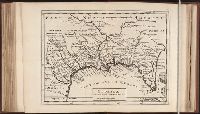
- Beinecke Rare Book and Manuscript Library > Africa
- Call Number:
- Ck3 35p
- Collection Title:
- Missive van William Penn ... : Geschreven aan de commissarissen van de Vrye Societeyt der
- Image Count:
- 1
- Found in:
- Beinecke Rare Book and Manuscript Library > Afteykeninge van de Stadt Philadelphia in de Provinstie van Penn-sylvania in Americae na de Copie tot London. en intneder duyts laeten Snyden door Jacob Claus
- Call Number:
- 1977 +392
- Collection Title:
- A survey of the cities of London and Westminster : containing the original, antiquity, increase
- Image Count:
- 1
- Found in:
- Beinecke Rare Book and Manuscript Library > Alders Gate Ward and St. Martins le grand liberty taken from the last survey with corrections
- Call Number:
- 1977 +392
- Collection Title:
- A survey of the cities of London and Westminster : containing the original, antiquity, increase
- Image Count:
- 1
- Resource Type:
- Maps, Atlases & Globes
- Found in:
- Beinecke Rare Book and Manuscript Library > Aldgate Ward with its division into parishes. Taken from the last survey, with corrections & additions
- Call Number:
- Taylor 192 4-6
- Collection Title:
- Americae pars sexta, sive, Historiae ab Hieronymo Be[n]zono Mediolane[n]se scriptae, sectio tertia
- Image Count:
- 1
- Found in:
- Beinecke Rare Book and Manuscript Library > America Sive Novus Orbis Respectu Europaeorum Inferior Globe Terrestris Pars 1596
- Published / Created:
- Undated
- Call Number:
- Taylor 355
- Collection Title:
- America painted to the life. The true history of the Spaniards proceedings in the conquests of the
- Image Count:
- 1
- Found in:
- Beinecke Rare Book and Manuscript Library > Americae descrip
- Call Number:
- Taylor 192 13
- Collection Title:
- Decima tertia pars historiae Americanae, qvae continet exactam et accvratam descriptionem I. Novae
- Image Count:
- 1
- Found in:
- Beinecke Rare Book and Manuscript Library > American nouiter delineata
- Creator:
- Russell, John, fl. 1733-1795
- Published / Created:
- 1794 October 18
- Call Number:
- 1986 102
- Collection Title:
- An historical, geographical, commercial, and philosophical view of the American United States, and
- Image Count:
- 1
- Found in:
- Beinecke Rare Book and Manuscript Library > An Accurate map of the United States of America. according to the Treaty of Peace of 1783
- Creator:
- Bruff, Joseph Goldsborough, 1804-1889
- Published / Created:
- 1849 April 2-August 27
- Call Number:
- WA MSS 50
- Collection Title:
- Diaries, journals, and notebooks
- Container / Volume:
- Box 1
- Image Count:
- 124
- Found in:
- Beinecke Rare Book and Manuscript Library > An account of the great emmigration across the continent, to California, in 1849. Adventures in California &c. &c. with copious illustrations ... in California ... by J. Goldsborough Bruff of Washington City
- Call Number:
- 1978 +73
- Collection Title:
- The ecclesiastical history of New-England from its first planting in the year 1620 unto the year of
- Image Count:
- 1
- Resource Type:
- Books, Journals & Pamphlets
- Found in:
- Beinecke Rare Book and Manuscript Library > An exact mapp of New England and New York
- Creator:
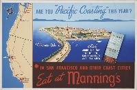
- Mannings Coffee Cafes
Schueler, Dorner Turner, 1904-1986
- Published / Created:
- [1939?]
- Call Number:
- BrSides Zc72 939ar
- Image Count:
- 1
- Found in:
- Beinecke Rare Book and Manuscript Library > Are you ""Pacific coasting"" this year?
- Published / Created:
- [1542]
- Call Number:
- Taylor 86
- Collection Title:
- Rvdimenta cosmographica
- Image Count:
- 1
- Found in:
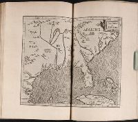
- Beinecke Rare Book and Manuscript Library > Asia
- Published / Created:
- [1542]
- Call Number:
- Taylor 86
- Collection Title:
- Rvdimenta cosmographica
- Image Count:
- 1
- Found in:
- Beinecke Rare Book and Manuscript Library > Asia Minor
- Creator:
- Visscher, Nicolaes, 1618-1679
- Published / Created:
- anno 1653
- Call Number:
- 1983 Folio 19
- Collection Title:
- [Atlas factice of 96 maps by Blaeu, Visscher, Jansson, Hondius and others]
- Image Count:
- 2
- Resource Type:
- Maps, Atlases & Globes
- Found in:
- Beinecke Rare Book and Manuscript Library > Asiae nova descriptio / auctore Nicola. Io. Visscher
- Creator:
- Moll, Herman, d. 1732
- Published / Created:
- [1732]
- Call Number:
- E1015 M66 1732
- Image Count:
- 1
- Found in:
- Beinecke Rare Book and Manuscript Library > Atlas minor: or a set of sixty-two new and correct maps, of all parts of the world. All composed and done by Herman Moll, geographer ...
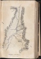
- Creator:
- Edward Weber & Co
- Call Number:
- Zc10 845fr
- Collection Title:
- Report of the exploring expedition to the Rocky Mountains in the year 1842, and to Oregon and north
- Image Count:
- 1
- Found in:
- Beinecke Rare Book and Manuscript Library > Beer Springs
- Call Number:
- 1977 +392
- Collection Title:
- A survey of the cities of London and Westminster : containing the original, antiquity, increase
- Image Count:
- 1
- Found in:
- Beinecke Rare Book and Manuscript Library > Billings Gate Ward and Bridge Ward within with it's division into parishes, taken from the last survey
- Call Number:
- 1977 +392
- Collection Title:
- A survey of the cities of London and Westminster : containing the original, antiquity, increase
- Image Count:
- 1
- Resource Type:
- Maps, Atlases & Globes
- Found in:
- Beinecke Rare Book and Manuscript Library > Bishop Gate Street Ward taken from the last survey and corrected
- Call Number:
- 1977 +392
- Collection Title:
- A survey of the cities of London and Westminster : containing the original, antiquity, increase
- Image Count:
- 1
- Resource Type:
- Maps, Atlases & Globes
- Found in:
- Beinecke Rare Book and Manuscript Library > Bread Street Ward and Cordwainer Ward with it's division into parishes taken from the last survey
- Call Number:
- 1977 +392
- Collection Title:
- A survey of the cities of London and Westminster : containing the original, antiquity, increase
- Image Count:
- 1
- Resource Type:
- Maps, Atlases & Globes
- Found in:
- Beinecke Rare Book and Manuscript Library > Candlewick Ward with its division into parishes. Corrected from the last survey
- Creator:
- Moll, Herman, d. 1732
- Published / Created:
- [1732]
- Call Number:
- E1015 M66 1732
- Collection Title:
- Atlas minor: or a set of sixty-two new and correct maps, of all parts of the world. All composed
- Image Count:
- 1
- Found in:
- Beinecke Rare Book and Manuscript Library > Carolina by H. Moll geographer.
- Creator:
- Cardano, Jose Maria
Morata, Antonio?
- Call Number:
- Zc70 +802ea
- Collection Title:
- Relacion del viage hecho por las goletas Sutil y Mexicana en el ano de 1792, para reconocer el
- Image Count:
- 1
- Found in:
- Beinecke Rare Book and Manuscript Library > Carta esferica de los reconocimientos hechos en la costa N.O. de America en 1791 y 92 por las goletas Sutil y Mexicana y otros buques de S.M. Map No. 1
- Creator:
- Cardano, Jose Maria
- Call Number:
- Zc70 +802ea
- Collection Title:
- Relacion del viage hecho por las goletas Sutil y Mexicana en el ano de 1792, para reconocer el
- Image Count:
- 1
- Found in:
- Beinecke Rare Book and Manuscript Library > Carta esferica de los reconocimientos hechos en la costa N.O. de America en 1791 y 92 por las goletas Sutil y Mexicana y otros buques de S.M. Map no. 2
- Call Number:
- Taylor 257
- Collection Title:
- Les voyages dv sievr de Champlain Xaintongeois, capitaine ordinaire pour le Roy, en la marine
- Image Count:
- 1
- Found in:
- Beinecke Rare Book and Manuscript Library > Carte Geographiqve de la Novvelle Franse Faictte Par Le Sievr de [Champlain]
- Creator:
- Bouttats, Gaspard, b. ca. 1640, engraver
- Call Number:
- Pequot H41
- Collection Title:
- Aenmerckelycke historische reys-beschryvinge door verscheyde landen veel grooter als die van geheel
- Image Count:
- 1
- Found in:
- Beinecke Rare Book and Manuscript Library > Carte d'un nouueau monde, entre le nouueau Mexique et la mer glacialle
- Call Number:
- Cm87 48th
- Collection Title:
- Histoire de Kentucke : nouvelle colonie a l'ouest de al Virginie: contenant, 1o, La decouverte
- Image Count:
- 1
- Found in:
- Beinecke Rare Book and Manuscript Library > Carte de Kentucke, d'apres les observations actuelles: dediee a L'Honorable Congres des Etats-Unis de l'Amerique et a Son Excellence George Washington, Commandant en chef de ses armees par leur tres humble serviteur, John Filson
- Call Number:
- Zc20 758Le
- Collection Title:
- Histoire de la Louisiane : contenant la decouverte de ce vaste pays ; sa description geographique
- Image Count:
- 1
- Found in:
- Beinecke Rare Book and Manuscript Library > Carte de la Louisiane colonie francaise avec le cours du fleuve St. Louis, les rivieres adjacentes, les nations de naturels, las etablissems francais, et les mines. Par l'Auteur de l'Histoire de cette Province 1757
- Call Number:
- Taylor 257
- Collection Title:
- Les voyages dv sievr de Champlain Xaintongeois, capitaine ordinaire pour le Roy, en la marine
- Image Count:
- 1
- Found in:
- Beinecke Rare Book and Manuscript Library > Carte geographique de la nouelle Franse en son vray mondia
- Call Number:
- Taylor 257
- Collection Title:
- Les voyages dv sievr de Champlain Xaintongeois, capitaine ordinaire pour le Roy, en la marine
- Image Count:
- 1
- Found in:
- Beinecke Rare Book and Manuscript Library > Champlain Saint Tongois Cappitaine Ordinaire povr le Roy en la Marine
- Call Number:
- 1977 +392
- Collection Title:
- A survey of the cities of London and Westminster : containing the original, antiquity, increase
- Image Count:
- 1
- Resource Type:
- Maps, Atlases & Globes
- Found in:
- Beinecke Rare Book and Manuscript Library > Cheape Ward with its division into parishes, taken from the last survey, with corrections and additions
- Creator:
- Braun, Georg, 1540 or 1-1622
Hierat, Anton, fl.1597-1627
Hogenberg, Abraham, fl. 1608-1653
Hogenberg, Franz, d. 1590?
- Published / Created:
- 1572]-1618
- Call Number:
- 1975 Folio 41
- Image Count:
- 1
- Resource Type:
- Maps, Atlases & Globes
- Found in:
- Beinecke Rare Book and Manuscript Library > Civitates orbis terrarvm ...
- Call Number:
- 1977 +392
- Collection Title:
- A survey of the cities of London and Westminster : containing the original, antiquity, increase
- Image Count:
- 1
- Resource Type:
- Maps, Atlases & Globes
- Found in:
- Beinecke Rare Book and Manuscript Library > Coleman Street Ward and Bashishaw Ward taken from the last survey, with corrections and additions
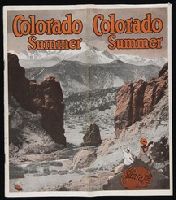
- Published / Created:
- 1922
- Call Number:
- Zc49 922cq
- Image Count:
- 32
- Found in:
- Beinecke Rare Book and Manuscript Library > Colorado summer
- Creator:
- Cornell, D. E.
Kansas Pacific Railway Company
- Published / Created:
- 1878
- Call Number:
- Zc49 +878co
- Image Count:
- 36
- Resource Type:
- Books, Journals & Pamphlets
- Found in:
- Beinecke Rare Book and Manuscript Library > Colorado tourist and illustrated guide via the "Golden Belt Route," to the Rocky Mountain resorts
- Creator:
- Cardano, Jose Maria
Morata, Antonio?
- Call Number:
- Zc70 +802ea
- Collection Title:
- Relacion del viage hecho por las goletas Sutil y Mexicana en el ano de 1792, para reconocer el
- Image Count:
- 1
- Found in:
- Beinecke Rare Book and Manuscript Library > Contiuacion de los reconocimientos hechos en la costa NO. de America por los buques de S.M. en varias campanas desde 1774 a 1792. Map no. 3
- Published / Created:
- [1897?]
- Call Number:
- Zc86 897cq
- Image Count:
- 5
- Resource Type:
- Books, Journals & Pamphlets
- Found in:
- Beinecke Rare Book and Manuscript Library > Copper River, Alaska : Pacific Steam Whaling Co., all American Route ...
- Call Number:
- 1977 +392
- Collection Title:
- A survey of the cities of London and Westminster : containing the original, antiquity, increase
- Image Count:
- 1
- Resource Type:
- Maps, Atlases & Globes
- Found in:
- Beinecke Rare Book and Manuscript Library > Cornhill Ward with its division into parishes, taken from the last survey &c
- Call Number:
- 1977 +392
- Collection Title:
- A survey of the cities of London and Westminster : containing the original, antiquity, increase
- Image Count:
- 1
- Resource Type:
- Maps, Atlases & Globes
- Found in:
- Beinecke Rare Book and Manuscript Library > Cow Cross being St. Sepulcher's parish without and the Charter House taken from the last survey with corrections
- Creator:
- P. Gaultier
- Published / Created:
- 1754
- Call Number:
- Folio J 176
- Collection Title:
- Le pitture antiche d’Ercolano e contorni incise con qualche spiegazione
- Image Count:
- 1
- Resource Type:
- Books, Journals & Pamphlets
- Found in:
- Beinecke Rare Book and Manuscript Library > Cratere maritimo, o parte del Golfo di Napoli
- Call Number:
- 1977 +392
- Collection Title:
- A survey of the cities of London and Westminster : containing the original, antiquity, increase
- Image Count:
- 1
- Found in:
- Beinecke Rare Book and Manuscript Library > Creple Gate Ward with its division into parishes, taken from the last survey, with additions and corrections
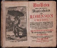
- Creator:
- Defoe, Daniel, 1661?-1731
- Published / Created:
- 1720
- Call Number:
- Defoe 52 n720e
- Image Count:
- 14
- Resource Type:
- Books, Journals & Pamphlets
- Found in:
- Beinecke Rare Book and Manuscript Library > Das Leben und die gantz ungemeine Begebenheiten des Robinson Crusoe ...
- Creator:
- Keulen, Gerard van
Keulen, Johannes van.
Marre, Jan de, 1696-1763.
Vooght, Claes Janszoon, d. 1696.
- Call Number:
- 1973 Folio 103
- Collection Title:
- De Nieuwe groote lichtende zee-fakkel ...
- Image Count:
- 1
- Resource Type:
- Maps, Atlases & Globes
- Found in:
- Beinecke Rare Book and Manuscript Library > De Oostin-dische zee / Het Eyland Mayota
- Creator:
- Keulen, Gerard van
Keulen, Johannes van.
Marre, Jan de, 1696-1763.
Vooght, Claes Janszoon, d. 1696.
- Call Number:
- 1973 Folio 103
- Collection Title:
- De Nieuwe groote lichtende zee-fakkel ...
- Image Count:
- 1
- Resource Type:
- Maps, Atlases & Globes
- Found in:
- Beinecke Rare Book and Manuscript Library > Des rivier legt op de Hoogte von 18 Graaden Zuyder Breedte aan het Land van de Megosie ter Kuste van Quama / Noord kust van't eyland ...
- Creator:
- Elstracke, Renold, fl. 1590-1630
- Published / Created:
- 1625
- Call Number:
- Pequot +P978
- Collection Title:
- Purchas his pilgrimes : In fiue bookes. The first, contayning the voyages and peregrinations made
- Image Count:
- 1
- Found in:
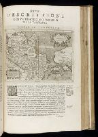
- Beinecke Rare Book and Manuscript Library > Description of East India
- Call Number:
- 1977 +250
- Collection Title:
- Geografia; cioe, Descrittione vniversale della terra. Partita in due volumi, nel primo de’ quali si
- Image Count:
- 1
- Found in:
- Beinecke Rare Book and Manuscript Library > Descrittione del potentissimo imperio della Tartaria
- Call Number:
- 1985 +31
- Collection Title:
- L'isole piu famose del mondo / descritte da Thomaso Porcacchi da Castiglione Arretino e intagliate
- Image Count:
- 1
- Resource Type:
- Maps, Atlases & Globes
- Found in:
- Beinecke Rare Book and Manuscript Library > Descrittione dell'isola Cuba, che dal Colombo fu scoperta insieme con la Spagnuloa
- Call Number:
- 1985 +31
- Collection Title:
- L'isole piu famose del mondo / descritte da Thomaso Porcacchi da Castiglione Arretino e intagliate
- Image Count:
- 1
- Resource Type:
- Maps, Atlases & Globes
- Found in:
- Beinecke Rare Book and Manuscript Library > Descrittione dell'isola Spagnuola prima iso la scoperta dal Colombo
- Creator:
- Downie, William, 1819-1894
Duneau, James
- Published / Created:
- 1861 July 4-21
- Call Number:
- WA MSS S-2490
- Collection Title:
- William Downie papers relating to exploration of British Columbia
- Container / Volume:
- Box 1 | Folder 3
- Image Count:
- 20
- Resource Type:
- Archives or Manuscripts
- Found in:
- Beinecke Rare Book and Manuscript Library > Diary
- Creator:
- Sotzmann, D. F
- Call Number:
- Zm Sp79
- Collection Title:
- Allgemeines historisches Taschenbuch, oder, Abriss der merkwurdigsten neuen Welt-Begebenheiten
- Image Count:
- 1
- Found in:
- Beinecke Rare Book and Manuscript Library > Die Vereinigten Staaten von Nord America. nach der von Wm Faden 1783
- Published / Created:
- [ca. 1675]
- Call Number:
- GEN MSS VOL 4
- Collection Title:
- Atlas of the world
- Image Count:
- 1
- Resource Type:
- Maps, Atlases & Globes
- Found in:
- Beinecke Rare Book and Manuscript Library > Die gantse welt
- Creator:
- Catherwood, Frederick
Colen, John H
- Call Number:
- Za P752 ZzP17
- Collection Title:
- Incidents of travel in Central America, Chiapas, and Yucatan / by John L. Stephens
- Image Count:
- 1
- Found in:
- Beinecke Rare Book and Manuscript Library > Distant view of the ruins & Santa Cruz del Quiche
- Published / Created:
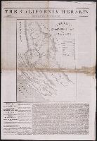
- 1848 December 26
- Call Number:
- AN33 N5 C128
- Collection Title:
- California herald (New York, N.Y.)
- Image Count:
- 1
- Resource Type:
- Books, Journals & Pamphlets
- Found in:
- Beinecke Rare Book and Manuscript Library > El Dorado in the United States of America: the discovery of inexhaustible gold mines in California
- Creator:
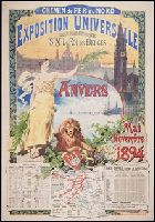
- Fraipont, G. (Gustave), b. 1849
- Published / Created:
- [1894?]
- Call Number:
- BrSides Folio 2006 35
- Image Count:
- 1
- Found in:
- Beinecke Rare Book and Manuscript Library > Exposition universelle sous le haut patronage de S.M. Le Roi des Belges.
- Creator:
- Downie, William, 1819-1894
Duneau, James
- Published / Created:
- 1860 February 17-November 26
- Call Number:
- WA MSS S-2490
- Collection Title:
- William Downie papers relating to exploration of British Columbia
- Container / Volume:
- Box 1 | 1a
- Image Count:
- 153
- Resource Type:
- Archives or Manuscripts
- Found in:
- Beinecke Rare Book and Manuscript Library > Family Register, manuscript diary
- Call Number:
- 1977 +392
- Collection Title:
- A survey of the cities of London and Westminster : containing the original, antiquity, increase
- Image Count:
- 1
- Resource Type:
- Maps, Atlases & Globes
- Found in:
- Beinecke Rare Book and Manuscript Library > Farington Ward without, with its divisions into parishes, taken from the last survey with corrections & amendments
- Creator:
- Moll, Herman, d. 1732
- Published / Created:
- [1732]
- Call Number:
- E1015 M66 1732
- Collection Title:
- Atlas minor: or a set of sixty-two new and correct maps, of all parts of the world. All composed
- Image Count:
- 1
- Found in:
- Beinecke Rare Book and Manuscript Library > Florida called by ye French Louisiana & c. By H. Moll geographer.
- Call Number:
- Taylor 210
- Collection Title:
- Chronologicarvm demonstrationvm libri tres. Ioannis Temporarii. Qvorvm primo, temporum series, a
- Image Count:
- 1
- Found in:
- Beinecke Rare Book and Manuscript Library > Florida et Apalche