Search
You Searched For
Search Results
- Published / Created:
- [1665?]
- Call Number:
- 28 1665
- Container / Volume:
- BRBL_00023E
- Image Count:
- 1
- Resource Type:
- Maps, Atlases & Globes
- Found in:
- Beinecke Rare Book and Manuscript Library > [Philippine Islands. By Johannes Vingboons. ca. 1665]
- Published / Created:
- 1940?]
- Call Number:
- 331 1940
- Container / Volume:
- BRBL_00079
- Image Count:
- 1
- Resource Type:
- Maps, Atlases & Globes
- Found in:
- Beinecke Rare Book and Manuscript Library > [Netherlands-Belgium border region]
- Published / Created:
- Undated
- Call Number:
- 1983 Folio 1
- Collection Title:
- Chertezhnai'a' kniga Sibiri, sostavlennai'a' tobol'skim synom boi'a'rskim Semenom Remezovym v 1701
- Image Count:
- 1
- Resource Type:
- Books, Journals & Pamphlets
- Found in:
- Beinecke Rare Book and Manuscript Library > [Map of southern Siberia]
- Published / Created:
- 1618?
- Call Number:
- Taylor 278
- Collection Title:
- Jovrnal ou Description dv merveillevx voyage de Gvillavme Schovten, hollandois natif de Hoorn
- Image Count:
- 1
- Found in:
- Beinecke Rare Book and Manuscript Library > [Map of Nova Guinea]
- Published / Created:
- [1633?]
- Call Number:
- 32 1633
- Container / Volume:
- BRBL_00042
- Image Count:
- 7
- Resource Type:
- Maps, Atlases & Globes
- Found in:
- Beinecke Rare Book and Manuscript Library > [England & Wales]
- Published / Created:
- [Ca. 1612]
- Call Number:
- Taylor 258
- Collection Title:
- Descriptio ac delineatio geographica detectionis freti, sive, transitus ad occasum supra terras
- Image Count:
- 1
- Found in:
- Beinecke Rare Book and Manuscript Library > [Barents Sea and Norwegian Sea]
- Published / Created:
- [Ca. 1612]
- Call Number:
- Pequot G325
- Collection Title:
- Descriptio ac delineatio geographica detectionis freti, sive, transitus ad occasum supra terras
- Image Count:
- 1
- Found in:
- Beinecke Rare Book and Manuscript Library > [Barents Sea and Norwegian Sea]
- Published / Created:
- 1899
- Call Number:
- 642 1899D
- Container / Volume:
- BRBL_00339
- Image Count:
- 2
- Resource Type:
- Maps, Atlases & Globes
- Found in:
- Beinecke Rare Book and Manuscript Library > Zuid-Afrikaansche Republiek, Oranje-Vrijstaat, Natal, Enz. [cartographic material] / Steendr. Senefelder, Amst.
- Published / Created:
- [1895?]
- Call Number:
- 643 1895
- Container / Volume:
- BRBL_00339
- Image Count:
- 1
- Resource Type:
- Maps, Atlases & Globes
- Found in:
- Beinecke Rare Book and Manuscript Library > Zuid Afrikaansche Republiek.
- Creator:
- Tirion, Isaak
- Published / Created:
- 1744
- Call Number:
- 11 1744A
- Container / Volume:
- BRBL_00681
- Image Count:
- 1
- Resource Type:
- Maps, Atlases & Globes
- Found in:
- Beinecke Rare Book and Manuscript Library > Wereld kaart [cartographic material] : na de alderlaatste ontdekking in't licht gebragt / by Isaak Tirion.
- Published / Created:
- ca. 1908.
- Call Number:
- 331 B45 1908
- Container / Volume:
- BRBL_00079
- Image Count:
- 2
- Resource Type:
- Maps, Atlases & Globes
- Found in:
- Beinecke Rare Book and Manuscript Library > Wandelkaart van Bergen en Bergen aan/Zee.
- Published / Created:
- 1908
- Call Number:
- 331 Sc29 1908
- Container / Volume:
- BRBL_00080
- Image Count:
- 1
- Resource Type:
- Maps, Atlases & Globes
- Found in:
- Beinecke Rare Book and Manuscript Library > Van Vogelenzang Tot Scheveningen.
- Creator:
- Linschoten, Jan Huygen van, 1563-1611
- Published / Created:
- 1596]
- Call Number:
- 64 1596
- Container / Volume:
- BRBL_00337
- Image Count:
- 1
- Resource Type:
- Maps, Atlases & Globes
- Found in:
- Beinecke Rare Book and Manuscript Library > Typus orarum maritimarum Guineae, Manicongo, & Angôlae ultra promontorium Bonae Spei ... [cartographic material] = Afheeldinghe der custen des landts Guinea, Manicongo, ende Angôla, ende voorts tot voorby de C. de boa esperança ... / Arnoldus F. á Lan
- Creator:
- Langren, Arnold Florent van, 1580-1644
- Published / Created:
- [1596]
- Call Number:
- Pequot +L65
- Collection Title:
- Nauigatio ac itinerarium Iohannis Hugonis Linscotani in Orientalem siue Lusitanorum Indiam
- Image Count:
- 1
- Found in:
- Beinecke Rare Book and Manuscript Library > Typus orarum maritimarum Guineae, Manicongo & Angolae ultra promontorium Bonae Spei ...
- Creator:
- Langren, Arnold Florent van, 1580-1644
- Published / Created:
- [1596]
- Call Number:
- Taylor 219
- Collection Title:
- Navigatio ac itinerarivm Iohannis Hvgonis Linscotani in Orientalem sive Lvsitanorvm Indiam
- Image Count:
- 1
- Found in:
- Beinecke Rare Book and Manuscript Library > Typus orarum maritimarum Guineae, Manicongo & Angolae ultra promontorium Bonae Spei ...
- Creator:
- Langren, Arnold Florent van, 1580-1644
- Published / Created:
- [1596?]
- Call Number:
- Z3 017
- Collection Title:
- ... Iohn Hvighen van Linschoten. his Discours of Voyages into ye Easte & West Indies. Deuided into
- Image Count:
- 1
- Found in:
- Beinecke Rare Book and Manuscript Library > Typus orarum maritimarum Guineae, Manicongo & Angolae ultra promontorium Bonae Spei ...
- Published / Created:
- [1600?]
- Call Number:
- 30 1600
- Container / Volume:
- BRBL_00029
- Image Count:
- 1
- Resource Type:
- Maps, Atlases & Globes
- Found in:
- Beinecke Rare Book and Manuscript Library > Totius Europae littora novissime edita. Pascaert vertoonende alle de See-custen van Europa.
- Creator:
- Topografische Inrichting (Jakarta, Indonesia)
- Published / Created:
- 1894
- Call Number:
- 2767 1894
- Container / Volume:
- BRBL_00023D
- Image Count:
- 1
- Resource Type:
- Maps, Atlases & Globes
- Found in:
- Beinecke Rare Book and Manuscript Library > Topographische kaart van het eiland Billiton : vluchtig opgenomen in de jaren 1877-1878.
- Creator:
- Waghenaer, Lucas Janszoon, 1534 or 5-1606
- Published / Created:
- ann. 1605.
- Call Number:
- 1976 Folio 46
- Image Count:
- 1
- Resource Type:
- Maps, Atlases & Globes
- Found in:
- Beinecke Rare Book and Manuscript Library > The mariners mirrovr wherin may playnly be seen the courses, heights, distances, depths, sounding, flouds and ebs, risings of lands, rocks ... of the harbouroughs, havens and ports of the greatest part of Europe: ... together w.th the rules and instrumeíÄ
- Creator:
- Waghenaer, Lucas Janszoon, 1534 or 5-1606
- Published / Created:
- ann. 1605.
- Call Number:
- 1976 Folio 46
- Image Count:
- 125
- Resource Type:
- Books, Journals & Pamphlets
- Found in:
- Beinecke Rare Book and Manuscript Library > The mariners mirrovr wherin may playnly be seen the courses, heights, distances, depths, sounding, flouds and ebs, risings of lands, rocks ... of the harbouroughs, havens and ports of the greatest part of Europe: ... together w.th the rules and instrumeíÄ
- Creator:
- Wit, Frederik de
- Published / Created:
- [ca. 1680?]
- Call Number:
- 51 1680
- Container / Volume:
- BRBL_00278
- Image Count:
- 1
- Resource Type:
- Maps, Atlases & Globes
- Found in:
- Beinecke Rare Book and Manuscript Library > Terra Sancta, sive Promissionis, olim Palestina / recens delineata, et in lucem edita per Fredericum de Wit.
- Call Number:
- 3321 1680
- Container / Volume:
- BRBL_00081
- Image Count:
- 1
- Resource Type:
- Maps, Atlases & Globes
- Found in:
- Beinecke Rare Book and Manuscript Library > Tabulae Dominii Groeningae quae et. ... Drentiae Emendata A.F. De Wit.
- Published / Created:
- 1612
- Call Number:
- Pequot G325
- Collection Title:
- Descriptio ac delineatio geographica detectionis freti, sive, transitus ad occasum supra terras
- Image Count:
- 1
- Found in:
- Beinecke Rare Book and Manuscript Library > Tabula nautica ...
- Creator:
- Topografische Inrichting (Jakarta, Indonesia)
- Published / Created:
- 1910
- Call Number:
- 27 1910
- Container / Volume:
- BRBL_00023A
- Image Count:
- 1
- Resource Type:
- Maps, Atlases & Globes
- Found in:
- Beinecke Rare Book and Manuscript Library > Stand van het kaarteeringswerk in den Nederlandsch O.I. Archipel.
- Published / Created:
- [1940?]
- Call Number:
- 331 L519 1940
- Container / Volume:
- BRBL_00080
- Image Count:
- 2
- Resource Type:
- Maps, Atlases & Globes
- Found in:
- Beinecke Rare Book and Manuscript Library > Stadtplan von Leeuwarden.
- Published / Created:
- [1940?]
- Call Number:
- 331 Ar62 1940
- Container / Volume:
- BRBL_00079
- Image Count:
- 2
- Resource Type:
- Maps, Atlases & Globes
- Found in:
- Beinecke Rare Book and Manuscript Library > Stadtplan von Arnhem.
- Creator:
- Nieuhof, Johannes, 1618-1672
Ogilby, John, 1600-1676
Ogilby, John, 1600-1676. Africa, being an accurate description of the regions of Egypt, Barbary
- Published / Created:
- 1670]
- Call Number:
- 215 1670
- Container / Volume:
- BRBL_00015
- Image Count:
- 1
- Resource Type:
- Maps, Atlases & Globes
- Found in:
- Beinecke Rare Book and Manuscript Library > St. Helena / door I.N.
- Published / Created:
- 1895?]
- Call Number:
- 642gme 1895
- Container / Volume:
- BRBL_00339
- Image Count:
- 1
- Resource Type:
- Maps, Atlases & Globes
- Found in:
- Beinecke Rare Book and Manuscript Library > Spoorwegen in Zuid Afrika [cartographic material].
- Published / Created:
- 1890?]
- Call Number:
- 642gme 1890
- Container / Volume:
- BRBL_00339
- Image Count:
- 1
- Resource Type:
- Maps, Atlases & Globes
- Found in:
- Beinecke Rare Book and Manuscript Library > Spoorwegen in Zuid Afrika [cartographic material] / J.H. de Bussy, Amst.
- Published / Created:
- 1829]
- Call Number:
- 186 1829
- Container / Volume:
- BRBL_00013
- Image Count:
- 2
- Resource Type:
- Maps, Atlases & Globes
- Found in:
- Beinecke Rare Book and Manuscript Library > Spitsbergen. R. Van Wyk Jacx del.
- Creator:
- Topografische Inrichting (Jakarta, Indonesia)
- Published / Created:
- 1916
- Call Number:
- 276 T16 1916
- Container / Volume:
- BRBL_00023C
- Image Count:
- 1
- Resource Type:
- Maps, Atlases & Globes
- Found in:
- Beinecke Rare Book and Manuscript Library > Schetskaart van het noordelijk gedeelte der residentie Tapanoeli / [door de] Topogr[aphische] Inrichting, Batavia.
- Creator:
- De Jongh, G. J. J
- Published / Created:
- 1916
- Call Number:
- 274 B63 1916
- Container / Volume:
- BRBL_00023B
- Image Count:
- 1
- Resource Type:
- Maps, Atlases & Globes
- Found in:
- Beinecke Rare Book and Manuscript Library > Schetskaart van het landschap Boeton / samengesteld door den kapitein der Inf. G.J.J. De Jongh.
- Creator:
- Topografische Inrichting (Jakarta, Indonesia)
- Published / Created:
- 1915
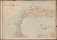
- Call Number:
- 2773 1915
- Container / Volume:
- BRBL_00023E
- Image Count:
- 1
- Resource Type:
- Maps, Atlases & Globes
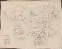
- Found in:
- Beinecke Rare Book and Manuscript Library > Schetskaart van het eiland Soemba.
- Creator:
- Topografische Inrichting (Jakarta, Indonesia)
- Published / Created:
- 1917
- Call Number:
- 2763 1917
- Container / Volume:
- BRBL_00023C
- Image Count:
- 1
- Resource Type:
- Maps, Atlases & Globes
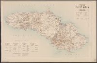
- Found in:
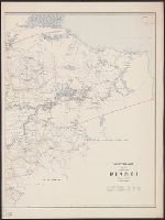
- Beinecke Rare Book and Manuscript Library > Schetskaart van het eiland Nias.
- Creator:
- Topografische Inrichting (Jakarta, Indonesia)
- Published / Created:
- 1905
- Call Number:
- 2751 1905
- Container / Volume:
- BRBL_00023C
- Image Count:
- 1
- Resource Type:
- Maps, Atlases & Globes
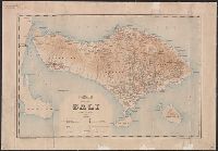
- Found in:
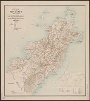
- Beinecke Rare Book and Manuscript Library > Schetskaart van het eiland Bali.
- Creator:
- Topografische Inrichting (Jakarta, Indonesia)
- Published / Created:
- 1911
- Call Number:
- 2775 Ad73 1911
- Container / Volume:
- BRBL_00023E
- Image Count:
- 1
- Resource Type:
- Maps, Atlases & Globes
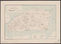
- Found in:
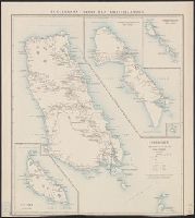
- Beinecke Rare Book and Manuscript Library > Schetskaart van het eiland Adonara.
- Creator:
- Topografische Inrichting (Jakarta, Indonesia)
- Published / Created:
- 1919
- Call Number:
- 274 1919
- Container / Volume:
- BRBL_00023B
- Image Count:
- 2
- Resource Type:
- Maps, Atlases & Globes
- Found in:
- Beinecke Rare Book and Manuscript Library > Schetskaart van een deel van Noord- en Midden-Celebes.
- Creator:
- Topographische Inrichting (Jakarta, Indonesia)
- Published / Created:
- 1910
- Call Number:
- 276 D64 1910A
- Container / Volume:
- BRBL_00023C
- Image Count:
- 2
- Resource Type:
- Maps, Atlases & Globes
- Found in:
- Beinecke Rare Book and Manuscript Library > Schetskaart van de Residentie Djambi / Topographische Inrichting.
- Creator:
- Dutch East Indies. Encyclopaedisch Bureau
- Published / Created:
- 1921
- Call Number:
- 274 M66 1921
- Container / Volume:
- BRBL_00023B
- Image Count:
- 1
- Resource Type:
- Maps, Atlases & Globes
- Found in:
- Beinecke Rare Book and Manuscript Library > Schetskaart van de Minahasa.
- Creator:
- Topographische Inrichting (Jakarta, Indonesia)
- Published / Created:
- 1910 [i.e. 1914]
- Call Number:
- 2765 1914
- Container / Volume:
- BRBL_00023C
- Image Count:
- 1
- Resource Type:
- Maps, Atlases & Globes
- Found in:
- Beinecke Rare Book and Manuscript Library > Schetskaart van de Mentawei-Eilanden / Topographische Inrichting.
- Creator:
- Topografische Inrichting (Jakarta, Indonesia)
- Published / Created:
- 1920
- Call Number:
- 2728 1920
- Container / Volume:
- BRBL_00023B
- Image Count:
- 1
- Resource Type:
- Maps, Atlases & Globes
- Found in:
- Beinecke Rare Book and Manuscript Library > Schetskaart van Timor : (Nederlandsch gebied).
- Creator:
- Netherlands. Topografische Inrichting
- Published / Created:
- 1919
- Call Number:
- 2692 1919
- Container / Volume:
- BRBL_00023A
- Image Count:
- 5
- Resource Type:
- Maps, Atlases & Globes
- Found in:
- Beinecke Rare Book and Manuscript Library > Schetskaart van Nieuw Guinee : (Nederlandsch gebied).
- Creator:
- Topografische Inrichting (Jakarta, Indonesia)
- Published / Created:
- 1920
- Call Number:
- 276CBF L19 1920
- Container / Volume:
- BRBL_00023C
- Image Count:
- 1
- Resource Type:
- Maps, Atlases & Globes
- Found in:
- Beinecke Rare Book and Manuscript Library > Residentie Lampongsche districten / bew. door het Encyclopaedisch bureau.
- Creator:
- Topografische Inrichting (Jakarta, Indonesia)
- Published / Created:
- 1910?]
- Call Number:
- 276 B43 1910
- Container / Volume:
- BRBL_00023C
- Image Count:
- 5
- Resource Type:
- Maps, Atlases & Globes
- Found in:
- Beinecke Rare Book and Manuscript Library > Residentie Benkoelen.
- Creator:
- Vinckeboons, Joan
- Published / Created:
- [1925?]
- Call Number:
- 5683 1665
- Container / Volume:
- BRBL_00300
- Image Count:
- 1
- Resource Type:
- Maps, Atlases & Globes
- Found in:
- Beinecke Rare Book and Manuscript Library > Platte grondt van Stadt Macao, waer in aen geweesen wordt de voornaemste Plaetsen der stadt.
- Published / Created:
- [1780?]
- Call Number:
- 11 1780A
- Container / Volume:
- BRBL_00006
- Image Count:
- 1
- Resource Type:
- Maps, Atlases & Globes
- Found in:
- Beinecke Rare Book and Manuscript Library > Platte Kaart van de Geheele Waereld om te dienen tot de Nederlandsche Reizen.
- Creator:
- Blaeu, Willem Janszoon, 1571-1638
- Published / Created:
- [between 1642 and 1664]
- Call Number:
- 97 1610
- Container / Volume:
- BRBL_00677
- Image Count:
- 2
- Resource Type:
- Maps, Atlases & Globes
- Found in:
- Beinecke Rare Book and Manuscript Library > Peru.
- Published / Created:
- [1650]
- Call Number:
- 352 B237 1650
- Container / Volume:
- BRBL_00723
- Image Count:
- 1
- Resource Type:
- Maps, Atlases & Globes
- Found in:
- Beinecke Rare Book and Manuscript Library > Paskaart vande noord kust van Moscovien ... / door Teunis Ys opgegeven ...
- Published / Created:
- [1681]
- Call Number:
- 303cea 1681
- Container / Volume:
- BRBL_00722
- Image Count:
- 1
- Resource Type:
- Maps, Atlases & Globes
- Found in:
- Beinecke Rare Book and Manuscript Library > Paskaart van't noordelykste deel der Noort Zee beginnende van der Neus tot Nova Zemla ...