
Search


Limit your search
- Public✖[remove]503
- Beinecke Rare Book and Manuscript Library✖[remove]503
- Maps in books✖[remove]503
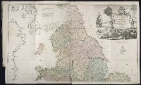
- Maps449
- Engravings395
- Hand coloring194
- Atlases96
- Illustrations80
- illustrations (AAT)22
- Marginalia20
- Frontispieces (Illustrations)18
- Intaglio prints18
- Berry, William, fl. 1669-1708, creator29
- Sanson, Nicolas, 1600-166725
- Moll, Herman, d. 173215
- Faden, William, 1749-1836, creator11
- Faden, William, 1749-18369
- Thornton, John, 1641-17089
- Sayer, Robert, 1725-17948
- Delarochette, L. (Louis), 1731-1802, creator7
- Gibson, J. (John)7
- Homann, Johann Baptist, 1663-17247
- Pilot guides --Caribbean Area --Early works to 1800156
- Navigation --Early works to 1800134
- Pilot guides --Atlantic Coast (U.S.) --Early works to 1800132
- Atlases --Early works to 180067
- Harbors --Atlantic Coast (North America) --Maps --Early works to 180024
- Nautical charts --Atlantic Coast (North America) --Early works to 180024
- Nautical charts --Caribbean Area --Early works to 180024
- Nautical charts --West Indies --Early works to 180024
- Pilot guides --Atlantic Coast (North America) --Early works to 180024
- Pilot guides --West Indies --Early works to 180024
- Nicholson, John, d. ca. 1717, bookseller66
- Barker, B. (Benjamin), d. 1764, bookseller24
- Clements, Henry, d. 1719, bookseller24
- King, Charles, d. 1735, bookseller24
- Parker, Richard, fl. 1692-1725, bookseller24
- Tooke, Benjamin, d. 1716, bookseller24
- Wolfe, John, d. 1601, printer7
- Peacock (Sloop of war : 1828-1841)5
- Eld, Edward4
- Eld, Henry,--1783-4