Depths shown by soundings., From Jefferys's The American atlas ... London : Printed and sold by R, Includes chart "Astronomical observations on which this chart is grounded.", and Sheet measures 55.1 x 73.8 cm. Stamped no. on verso: 13. Cross Collection no. 161.
Publisher:
Printed for & sold by Robt. Sayer & Jno. Bennett,
Subject (Geographic):
Grand Banks of Newfoundland--Maps--Early works to 1800
Subject (Name):
Chabert, Joseph Bernard, marquis de, 1724-1805, Cook, James, 1728-1779, Fleurieu, C. P. Claret (Charles Pierre Claret), comte de, 1738-1810, Jefferys, Thomas, d. 1771. American atlas, and Robert Sayer and John Benne
Subject (Topic):
Nautical charts--Newfoundland and Labrador--Grand Banks of Newfoundland--Early works to 1800
Depths shown by soundings., From Jefferys's The American atlas ... London : Printed and sold by R. Sayer and J. Bennett, 1776., Includes chart "Astronomical observations on which this chart is grounded.", Prime meridian: London, and Sheet measures 55.7 x 73.5 cm.
Publisher:
Printed for & sold by Robt. Sayer & Jno. Bennett,
Subject (Geographic):
Grand Banks of Newfoundland--Maps--Early works to 1800
Subject (Name):
Chabert, Joseph Bernard, marquis de,, Cook, James, 1728-1779, Fleurieu, C. P. Claret (Charles Pierre Claret), comte de, 1738-1810, Jefferys, Thomas, d. 1771. American atlas, and Robert Sayer and John Bennett (Firm)
Subject (Topic):
Nautical charts--Newfoundland and Labrador--Grand Banks of Newfoundland--Early works to 1800
Lucas, Fielding, 1781-1854 Warr, John, b. ca. 1798 Warr, William W
Published / Created:
[1862], c1852
Call Number:
21cea 1862
Image Count:
1
Resource Type:
Maps, Atlases & Globes
Alternative Title:
Chesapeake and Delaware Bays.
Description:
"Drawn by F. Lucas, Jr.", "Engraved by John and William W. Warr, Philadelphia.", "Sold by Lucas Brothers.", Depths shown by soundings and shading., and Includes views: View of the coast from Indian River to Cape Henlopen [Del.] -- Windmill Point [Va.] -- Smiths P
Publisher:
Fielding Lucas,
Subject (Geographic):
Chesapeake Bay Region (Md. and Va.)--Maps and Delaware Bay Region (Del. and N.J.)--Maps
Subject (Topic):
Coasts--Delaware--Maps, Coasts--Maryland--Maps, Coasts--New Jersey--Maps, and Coasts--Virginia--Maps
From Jefferys's The American atlas ... London : Printed and sold by R. Sayer and J. Bennett, 1776., Hand c, Includes listing of "Astronomical observations on which this chart is grounded.", Plate no "XI.", and Relief shown pictorially. Soundings shown in fathoms.
Publisher:
Printed & sold by Robt. Sayer & Jno. Bennett,
Subject (Geographic):
Saint Lawrence, Gulf of--Maps--Early works to 1800
Subject (Name):
Jefferys, Thomas, -1771. American atlas and Robert Sayer and John Bennett (Firm)
Subject (Topic):
Nautical charts--Saint Lawrence, Gulf of--Early works to 1800
Also appeared in Faden's General atlas. London : William Faden, 1811?., Depths shown by soundings., and Shows ports, sailing directions, etc.
Publisher:
Engraved & published by Wm. Faden,
Subject (Geographic):
Mediterranean Sea--Maps--Early works to 1800
Subject (Name):
Abbot, Charles,--Baron Colchester,--1757-1829--Bookplate and Faden, William, 1749-1836. General atlas
Subject (Topic):
Coasts--Africa, North--Maps--Early works to 1800, Coasts--Portugal--Maps--Early works to 1800, Coasts--Spain--Maps--Early works to 1800, Nautical charts--Africa, North--Early works to 1800, and Nautical charts--Medi
"Published by command of the Right Honourable the Lords of Trade & Plantations, for the benefit of the trade and navigation of Great Britain and its colonies.", Depths shown by soundings., Includes inscription to "George Du, and Oriented with north to the right.
Publisher:
[Thomas Jefferys?,
Subject (Geographic):
Halifax Harbour (N.S.)--Maps--Early works to 1800
Subject (Name):
Jefferys, Thomas, d. 1771
Subject (Topic):
Harbors--Nova Scotia--Halifax--Maps--Early works to 1800, Nautical charts--Nova Scotia--Halifax Harbour--Early works to 1800, and Nautical charts--Nova Scotia--Halifax--Early works to 1800
Cross Collection no. 288., From The Political magazine, vol. 1, p. 549., Prime meridian: London., Relief shown by hachures and pictorially; soundings in fatho, Scale given in miles., and Shows towns, parishes, roads, anchorages, etc.
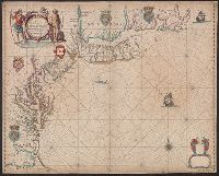
Appears in: John Seller, Atlas maritimus, 1675 (McCorkle 36)., Depths shown by soundings in Chesapeake Bay and south to Cape Hatteras., Includes decorative cartouche, coats of arms, and other ill. Lower right corner: empty cartouche., and Mounted on linen. Verso
Subject (Geographic):
Middle Atlantic States--Nautical charts--Early works to 1800 and New England--Nautical charts--Early works to 1800
Copper engraving, colored to show coasts of Eng., Decorative cartouche containing royal arms; on respective countries - coats of arms; compass rose - n. to right; Neptune carrying union jack in upper left; 2 ships, a whale., and Removed fr. the Atlas Maritimus.
Account of the voyages undertaken by the order of His present Majesty for making discoveries in the
Container / Volume:
BRBL_00683
Image Count:
1
Resource Type:
Maps, Atlases & Globes
Alternative Title:
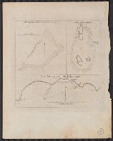
Joseph Freewills Islands. and South end of Mindanao.
Description:
Cross Collection 71., Depths shown by soundings., and From Hawkesworth's Account of the voyages undertaken by the order of His present Majesty for making discoveries in the Southern Hemisphere. London: Printed for W. Strahan and T. Cadell, 1773; v. 1, facing p.
Subject (Geographic):
Mapia Islands (Indonesia)--Maps--Early works to 1800 and Mindanao Island (Philippines)--Maps--Early works to 1800
Subject (Name):
Carteret, Philip, d. 1796 and Cook, James, 1728-1779
Subject (Topic):
Nautical charts--Indonesia--Mapia Island--Early works to 1800 and Nautical charts--Philippines--Mindanao Island--Early works to 1800