Skip to search
Skip to main content
Skip to first result
Yale University Library
Ask Yale Library
Reserve Rooms
Places to Study
Research
Quicksearch
Search Library Catalog (Orbis)
Search Law Library Catalog (MORRIS)
Search Borrow Direct
Search WorldCat
Search Articles+
Search Digital Collections
Search Archives at Yale
Research Guides
Find Databases by Title
Find eJournals by Title
Guide to Using Special Collections
Services
Your Personal Librarian
Subject Specialists
Research Support and Workshops
Citation Tools
OverDrive: Popular Audio and eBooks
Get It @ Yale (Borrow Direct, Interlibrary Loan, Scan & Deliver)
Course Reserves
Off-Campus Access
EliScholar
OverDrive: Popular Audio and eBooks
Bass Media Equipment
Libraries & Collections
Arts Library
Bass Library
Beinecke Library
Classics Library
Divinity Library
Film Study Center
Fortunoff Archive
Humanities Collections
International Collections
Law Library
Lewis Walpole Library
Library Collection Services
Manuscripts & Archives
Map Collection
Marx Science & Social Science Library
Medical Library
Music Library
Sterling Library
Yale Center for British Art
Information & Policies
Library Hours
Departments & Staff
Borrowing & Circulation
Services for Persons with Disabilities
Copyright Basics
Scanning, Printing & Copying
Computers & Wireless
Library Policies
About the Library
Giving to the Library
Purchase Request
Working at the Library
Terms Governing Use of Materials
Search in
All Fields
Creator
Title
Call Number
Date
Subject
Orbis ID
Full Text
Description
Full text
search for
Search
Search
Advanced Search
Digital Collections
Search
You Searched For
Subject (Geographic)
West Indies --Maps --Early works to 1800
New Search
« Previous
|
1
-
50
of
62
|
Next »
Sort
by relevance
relevance
Creator (A --> Z)
Creator (Z --> A)
Title (A --> Z)
Title (Z --> A)
Year (ascending)
Year (descending)
Number of results to display per page
50
per page
9
per page
30
per page
60
per page
99
per page
View results as:
List
List
Gallery
Gallery
Search Results
A chart of the Caribe Islands
A chart of the Caribe ilands
A chart of the iland of Hispaniola
A chart of the island of Hispaniola
A correct chart of Hispaniola with the Windward Passage
A correct chart of the Caribbee Islands
A draught of the island of Beata, on the south side of Hispaniola
A general chart of the West India
A general chart of the western ocean
A generall chart of the West Indies
A generall chart of the western ocean
A large draft of the island Antegua
A large draft of the island of Antegua
A new and correct chart of Cuba, streights of Bahama, Windward Passage, the current through the
A new and correct chart of the trading part of the West Indies
A new and correct draught of the Bay of Matanzas ...
A new and correct draught of the Bay of Matanzas on ye north side of ye island Cuba ...
A new and correct draught of the Bay of Matanzas, on ye north side of ye island Cuba done from a
A new and correct large chart of the tradeing part of the West Indies
A new chart of the Bahama Islands and the Windward Passage
A new chart of the Bahama Islands and the Windward passage
A new generall chart for the West Indies
A new mapp of the island of St. Christophers
Aiguiade de Port o Rico
Barbados
Delineatio omnium orarum totius Australis partis Americae, dictae Peruvianae, a R. de la Plata
Plan de la Rade du Port Paix
Plan du Cap Francois
Plan du cul de sac de Leogane ou le Port au Prince
Plan of Blewfield's Harbour on the island of Jamaica
Plan of Cape Nichola Mole at the n.w. end of the island of Hispaniola
Plan of Lucia Harbour on the north side of Jamaica
Plan of Mantica Bay on the north side of Jamaica
Plan of Port Antonio on the north-east side of Jamaica
Plan of Port Royal harbour Rattan
PREVIOUS
«
1
2
»
NEXT
Limit your search
Extent of Digitization
Unspecified
50
Partially digitized
11
Completely digitized
1
Access
Public
62
Repository
Beinecke Rare Book and Manuscript Library
62
Format
cartographic
62
Genre
Engravings
62
Maps
62
Maps in books
62
Marginalia
5
Atlases
2
Hand coloring
2
Resource Type
Maps, Atlases & Globes
10
Language
English
58
French
3
Dutch; Flemish
1
Latin
1
Portuguese
1
Spanish; Castilian
1
Creator
Thornton, John, 1641-1708
4
Gibson, J. (John)
3
Pearson, Robert
3
Bayly, J
1
Bowen, Thomas, d. 1790
1
Langren, Arnold Florent van, 1580-1644
1
Lea, Philip, fl. 1683-1700, creator
1
Price, Charles, fl. 1700-1707
1
Speer, Joseph Smith., creator
1
Subject (Topic)
Pilot guides --Caribbean Area --Early works to 1800
59
Navigation --Early works to 1800
45
Pilot guides --Atlantic Coast (U.S.) --Early works to 1800
45
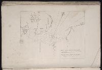
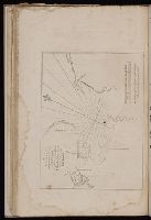
Harbors --Atlantic Coast (North America) --Maps --Early works to 1800
14
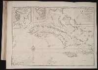
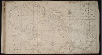
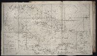
Nautical charts --Atlantic Coast (North America) --Early works to 1800
14
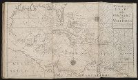
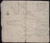
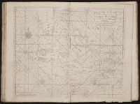
Nautical charts --Caribbean Area --Early works to 1800
14
Nautical charts --West Indies --Early works to 1800
14
Pilot guides --Atlantic Coast (North America) --Early works to 1800
14
Pilot guides --West Indies --Early works to 1800
14
Voyages and travels --Early works to 1800
1
Publication Place
Westminster
1
[London]
1
Date Created
View distribution
Current results range from
1596
to
1774
Date Created range begin
Date Created range end
View larger ยป
[Missing]
57