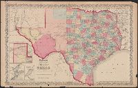
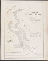
"No.35" and "No.36.", Includes Frio and Zavala counties which were formed in 1858 and which do not appear on Colton map dated 1857., Insets: Plan of the northern part of Te, and Library's copy annotated in pencil "This is in the same state as in the 1859 atlas."
Publisher:
Johnson & Browning,
Subject (Geographic):
Texas Panhandle (Tex.)--Maps, Texas--Administrative and political divisions--Maps, and Texas--Maps
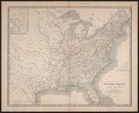
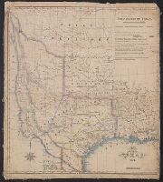
"English miles 69 to a degree" and "Spanish leagues 26 to a degree.", Covers southwest United States, Mexico, and part of Central America., From the Streeter collection., and Relief shown by hachures.
Publisher:
Longman, Rees, Orme, Brown & Green,
Subject (Geographic):
Central America--Maps, Mexico--Maps, and Southwest, New--Maps
Eastern part, post route map of the state of Texas. and Western part, post route map of the state of Texas.
Description:
"The first edition was issued in 1878.", "The service on this diagram brought up to date of February 1, 1879.", At head of title on cover of sheet 1: Eastern part., At head of title on cover of sheet 2: Western part., From the Stre, and Prime meridian: Washington.
In lower right margin: 43., Includes text notes., Inset: Sketch of the River Niagara. Scale [ca. 1:550 000]. 13 x 19 cm., Outline color., Relief shown by hachures., and Shows state and territorial boundaries, existing and proposed railroads and canals, lighthouses
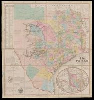
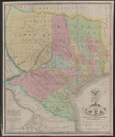
"Entered according to Act of Congress on the 28th day of July 1848 by J. De Cordova in the Clerks Office of the United States District Court for the District of Texas.", "Without my signature all copies of this map have been fraudulently obtained. J. De Cordova.", From the Streeter collection., Includes elliptical inset of southwestern U.S. and Mexico. Scale [ca. 1:9,000,000]., Includes list of land districts and text., Library's copy annotated in pencil and red ink., Prime meridians: Greenwich and Washington., Relief shown by hachures., and Shows counties.
Publisher:
s.n.],
Subject (Geographic):
Texas--Administrative and political divisions--Maps and Texas--Maps
"Though the map ... has an 1840 date, it appears from a letter of J.H. Overton, United States Commissioner, dated Opelousas, Louisiana, August 10 1841 ... and the reply of October 1, 1841 ... that the maps ... had not been forwarded at that time. However, they had been received by January 15, 1842 ... and that they were issued by March 17, 1842, is shown by the reprintings of them accompanying the President's Message of that date"--Streeter, Bibliography of Texas, 1438.
Publisher:
s.n.,
Subject (Geographic):
Sabine River (Tex. and La.)--Maps, Texas--Boundaries--United States--Maps, and United States--Boundaries--Texas--Maps
"The latitude and longitude of Saltillo, Monterey, Laredo, Bexar, Nacogdoches, and the point where the boundary line leaves the Sabine are from the observations of General Teran of the Mexican Army.", From the Streeter collection., and Includes coat of arms, "note", and table of numbers of families on principal tracts of land.
Publisher:
H.S. Tanner,
Subject (Geographic):
Texas--Maps
Subject (Name):
Streeter, Thomas W.--(Thomas Winthrop
Subject (Topic):
Land grants--Texas--Maps and Texas--Administrative and political divisions--Maps
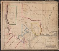
From Maillard's History of the Republic of Texas. London : Smith, Elder and Co., 1842., From the Streeter collection., Includes text., Library's copy annotated in pencil., Relief shown by hachures., and Shows "political, conventional and natural" boundaries of Texas, Indian tribes, Osage Territory, "Santa Fe, formerly New Mexico," and "Indian Territory attached to Arkansas."
Publisher:
Smith, Elder and Co.],
Subject (Geographic):
Mexico--Boundaries--Texas--Maps, Texas--Boundaries--Mexico--Maps, Texas--Boundaries--United States--Maps, Texas--Maps, and United States--Boundaries--Texas--Maps
From John Woodward's An abstract of the constitutions, laws and other documents having reference to, and including the impresario grants and contracts made by the State of Coahuila and Texas to and with John Charles Beales. New York : Narine & Co.'s Print, 1842., From the Streeter collection., Library's copy annotated in pencil., Prime meridians: Greenwich and Washington., Relief shown by hachures., and Shows in color boundaries of Arkansas Grant, Rio Grande Grant, Milam or Rio Coronado Grant, and Galveston Bay Grants.