
Search


Limit your search
- Public437
- Hand coloring✖[remove]437
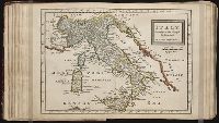
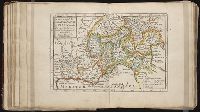
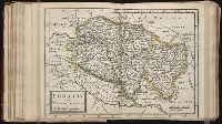
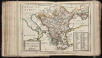
- Maps✖[remove]437
- Maps in books410
- Engravings325
- Atlases178
- Marginalia39
- Illustrations38
- Manuscripts18
- Illuminated manuscripts15
- Prints (Visual works)10
- Homann Erben (Firm)78
- Homann, Johann Baptist, 1663-172445
- Berry, William, fl. 1669-1708, creator29
- Sanson, Nicolas, 1600-166725
- Hase, Johann Matthias, 1684-174220
- Mayer, Tobias, 1723-176217
- Bellin, Jacques Nicolas, 1703-1772, creator14
- Visscher, Nicolaes, 1649-170214
- Faden, William, 1749-1836, creator13
- Anville, Jean Baptiste Bourguignon d', 1697-178211
- Nicholson, John, d. ca. 1717, bookseller65
- Barker, B. (Benjamin), d. 1764, bookseller24
- Clements, Henry, d. 1719, bookseller24
- King, Charles, d. 1735, bookseller24
- Parker, Richard, fl. 1692-1725, bookseller24
- Tooke, Benjamin, d. 1716, bookseller24
- Cook, James, 1728-17792
- Reiner et Josua Ottens (Firm)2
- Robert de Vaugondy, Didier, 1723-17862
- Sanchez de Bustamante, D. A2