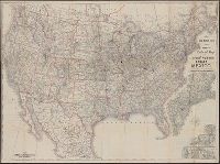
Search
You Searched For
Search Results
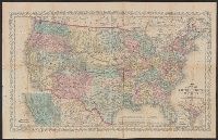
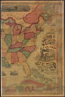
- Creator:
- United States. General Land Office
- Published / Created:
- 1876
- Call Number:
- 75 1876
- Container / Volume:
- BRBL_00405
- Image Count:
- 6
- Resource Type:
- Maps, Atlases & Globes
- Found in:
- Beinecke Rare Book and Manuscript Library > Map of the United States and territories, showing the extent of public surveys, Indian and military reservations, land grant R.R., rail roads, canals, and other details / compiled from the official surveys of the General Land Office, and other authentic s
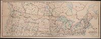
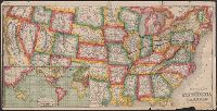
- Creator:
- Tanner, Henry Schenck, 1786-1858
- Published / Created:
- 1840
- Call Number:
- 75gm 1840B
- Container / Volume:
- BRBL_00410
- Image Count:
- 1
- Resource Type:
- Maps, Atlases & Globes
- Found in:
- Beinecke Rare Book and Manuscript Library > Map of the canals & rail roads of the United States / reduced from the large map of the U.S. by H.S. Tanner ; engraved by J. Knight.
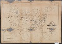
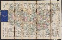
- Creator:
- Waddell, J. H. (John Hunter)
- Published / Created:
- 1868
- Call Number:
- 75GBC 1868
- Container / Volume:
- BRBL_00410
- Image Count:
- 1
- Resource Type:
- Maps, Atlases & Globes
- Found in:
- Beinecke Rare Book and Manuscript Library > Map of the United States / constructed on the rectangular tangential projection by J.H. Waddell ... ; prepared under the instructions M. F. Maury ...
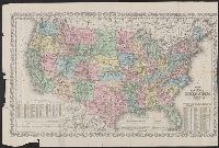
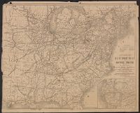
- Creator:
- Burr, Henry A
- Published / Created:
- 1853
- Call Number:
- 75GM 1853
- Container / Volume:
- BRBL_00410
- Image Count:
- 1
- Resource Type:
- Maps, Atlases & Globes
- Found in:
- Beinecke Rare Book and Manuscript Library > Disturnell's new map of the United States and Canada : showing all the canals, rail roads, telegraph lines and principal stage routes / Drawn by Henry A. Burr.
- Published / Created:
- 1853
- Call Number:
- 754gme 1853
- Container / Volume:
- BRBL_00419
- Image Count:
- 1
- Resource Type:
- Maps, Atlases & Globes
- Found in:
- Beinecke Rare Book and Manuscript Library > Map of the Delaware, Lackawanna & Western railroad : with its principal connections.
- Creator:
- J.H. Colton & Co.
- Published / Created:
- 1858
- Call Number:
- 754gme 1858
- Container / Volume:
- BRBL_00420
- Image Count:
- 1
- Resource Type:
- Maps, Atlases & Globes
- Found in:
- Beinecke Rare Book and Manuscript Library > Map of the Mississippi and Missouri Railroad : and its connections.
- Published / Created:
- [1857?]
- Call Number:
- 754gme 1857
- Container / Volume:
- BRBL_00419
- Image Count:
- 1
- Resource Type:
- Maps, Atlases & Globes
- Found in:
- Beinecke Rare Book and Manuscript Library > Map showing position of the Lake Erie and Pacific rail road : and its connections / [by] Chas. E. Hore, mechanical and topographical draftsman, 308 Broadway, N.Y.
- Creator:
- Poole Brothers
- Published / Created:
- [1901?], c1893.
- Call Number:
- 73eu 1901
- Container / Volume:
- BRBL_00375B
- Image Count:
- 1
- Resource Type:
- Maps, Atlases & Globes
- Found in:
- Beinecke Rare Book and Manuscript Library > Map of the Canadian Pacific Railway, the Minneapolis, St. Paul and Sault Ste. Marie Railway, the Duluth, South Shore and Atlantic Railway and connections / Poole Bros, engravers.
- Creator:
- Spencer Trask & Co
- Published / Created:
- c1906.
- Call Number:
- 75gme 1906A
- Container / Volume:
- BRBL_00414
- Image Count:
- 1
- Resource Type:
- Maps, Atlases & Globes
- Found in:
- Beinecke Rare Book and Manuscript Library > Trans-continental map : showing the main lines and proposed extentions of the various Trans-continental railroad systems of the Unites States and Canada, and some of the important connecting lines / Spencer Trask & Co. ; railroads drawn by Edward Aberle.
- Creator:
- Rand McNally and Company
- Published / Created:
- [ca. 1874].
- Call Number:
- 75gme 1874
- Container / Volume:
- BRBL_00412
- Image Count:
- 1
- Resource Type:
- Maps, Atlases & Globes
- Found in:
- Beinecke Rare Book and Manuscript Library > New map of the American overland route : showing its connections, and land grants of 30,000,000 acres / engraved and published by Rand McNally & Co.
- Creator:
- Ellet, Charles, 1810-1862
- Published / Created:
- 1851
- Call Number:
- 75gme 1851
- Container / Volume:
- BRBL_00411
- Image Count:
- 1
- Resource Type:
- Maps, Atlases & Globes
- Found in:
- Beinecke Rare Book and Manuscript Library > Map of the Western Railroads tributary to Philadelphia with their rival lines / prepared under the direction of Charles Ellet Jr., civil engineer ; by W. Williams, map engraver.
- Creator:
- Rand McNally and Company
- Published / Created:
- 1888
- Call Number:
- 75gme 1888
- Container / Volume:
- BRBL_00414
- Image Count:
- 1
- Resource Type:
- Maps, Atlases & Globes
- Found in:
- Beinecke Rare Book and Manuscript Library > The Duluth daily news map of the Duluth railway system : Showing lines completed, under construction, and projected, Jan. 1st, 1888.
- Creator:
- Rand McNally and Company
- Published / Created:
- [1882?]
- Call Number:
- 75gme 1882A
- Container / Volume:
- BRBL_00413
- Image Count:
- 1
- Resource Type:
- Maps, Atlases & Globes
- Found in:
- Beinecke Rare Book and Manuscript Library > New map of the United States showing the complete railway system of the trans-Missouri country / prepared expressly for Crofutt's New overland tourist and Pacific coast guide, 1882, the Overland Publishing Company, Omaha, Neb., and Denver, Colo.
- Published / Created:
- 1869
- Call Number:
- 75gme 1869
- Container / Volume:
- BRBL_00412
- Image Count:
- 1
- Resource Type:
- Maps, Atlases & Globes
- Found in:
- Beinecke Rare Book and Manuscript Library > The great railroad routes to the Pacific, and their connections : 1869 / [by Joseph Gorlinski, Draughtsman].
- Creator:
- Goldthwait, J. H
- Published / Created:
- 1861
- Call Number:
- 75 1861D
- Container / Volume:
- BRBL_00402
- Image Count:
- 1
- Resource Type:
- Maps, Atlases & Globes
- Found in:
- Beinecke Rare Book and Manuscript Library > Goldthwait's map of the United States & Canada : exhibiting the railroads with their distances, single and double tracks and width of gauge, and the time compared with noon at Washington & Greenwich / by J.H. Goldthwait.
- Creator:
- Young, J. H. (James Hamilton)
- Published / Created:
- 1857
- Call Number:
- 75 1857
- Container / Volume:
- BRBL_00401
- Image Count:
- 1
- Resource Type:
- Maps, Atlases & Globes
- Found in:
- Beinecke Rare Book and Manuscript Library > A new map of the United States of America / by J.H. Young ; engraved by J.L. Hazzard & E. Yeager.
- Published / Created:
- 1870
- Call Number:
- 80 1870B
- Container / Volume:
- BRBL_00535
- Image Count:
- 1
- Resource Type:
- Maps, Atlases & Globes
- Found in:
- Beinecke Rare Book and Manuscript Library > Map of the North West : from explorations by the United States Engineers & Royal Engineers of England and Union & Northern Pacific R.R. surveys.
- Creator:
- Waddell, J. H
- Published / Created:
- 1868?]
- Call Number:
- 75 1868
- Container / Volume:
- BRBL_00404
- Image Count:
- 1
- Resource Type:
- Maps, Atlases & Globes
- Found in:
- Beinecke Rare Book and Manuscript Library > Map of the United States / constructed on the rectangular tangential projection by J.H. Waddell ... ; prepared under the instructions M.F. Maury ...
- Creator:
- Young, J. H. (James Hamilton)
- Published / Created:
- [1864]
- Call Number:
- 75 1864B
- Container / Volume:
- BRBL_00403
- Image Count:
- 1
- Resource Type:
- Maps, Atlases & Globes
- Found in:
- Beinecke Rare Book and Manuscript Library > A new map of the United States of America [cartographic material] / by J.H. Young ; engraved by J.L. Hazzard & E. Yeager.
- Published / Created:
- [1870?]
- Call Number:
- 75gme 1870
- Container / Volume:
- BRBL_00412
- Image Count:
- 1
- Resource Type:
- Maps, Atlases & Globes
- Found in:
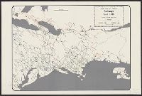
- Beinecke Rare Book and Manuscript Library > Map showing the location of the Northern Pacific Rail Road.
- Creator:
- Latrobe, Benj. H. (Benjamin Henry), 1807-1878
- Published / Created:
- 1850?]
- Call Number:
- 75gme 1850B
- Container / Volume:
- BRBL_00411
- Image Count:
- 1
- Resource Type:
- Maps, Atlases & Globes
- Found in:
- Beinecke Rare Book and Manuscript Library > Map, exhibiting the railway route between Baltimore & St. Louis, together with the other principal lines in the Eastern, Middle & Western states / prepared under the direction of B.H. Latrobe, Ch. Engr. B. & O.R.R. ; Lith. by A. Hoen & Co.
- Published / Created:
- [1885?]
- Call Number:
- 754 1885
- Container / Volume:
- BRBL_00417
- Image Count:
- 1
- Resource Type:
- Maps, Atlases & Globes
- Found in:
- Beinecke Rare Book and Manuscript Library > Topographical map of Virginia : also showing the states of Maryland and Delaware.
- Published / Created:
- 186-]
- Call Number:
- 754gme 1860B
- Container / Volume:
- BRBL_00420
- Image Count:
- 1
- Resource Type:
- Maps, Atlases & Globes
- Found in:
- Beinecke Rare Book and Manuscript Library > [Railroads of the Northern United States from Iowa to Boston, Massachusetts]
- Creator:
- Hutawa, Julius
- Published / Created:
- 1854?]
- Call Number:
- 75 1854A
- Container / Volume:
- BRBL_00401
- Image Count:
- 1
- Resource Type:
- Maps, Atlases & Globes
- Found in:
- Beinecke Rare Book and Manuscript Library > Map of the United States, shewing the principal steamboat routes and projected railroads connecting with St. Louis / Juls. Hutawa, lithr.
- Creator:
- Young, J. H. (James Hamilton)
- Published / Created:
- 1860, c1859.
- Call Number:
- 75 1859D
- Container / Volume:
- BRBL_00401
- Image Count:
- 1
- Resource Type:
- Maps, Atlases & Globes
- Found in:
- Beinecke Rare Book and Manuscript Library > A new map of the United States of America / by J.H. Young ; engraved by J.L. Hazzard & E. Yeager.
- Creator:
- G.W. & C.B. Colton & Co
- Published / Created:
- 1864
- Call Number:
- 75 1864
- Container / Volume:
- BRBL_00403
- Image Count:
- 1
- Resource Type:
- Maps, Atlases & Globes
- Found in:
- Beinecke Rare Book and Manuscript Library > Coltons' rail-road and military map of the United States, Mexico, the West Indies &c.
- Creator:
- Rand McNally and Company
- Published / Created:
- [1912]
- Call Number:
- 80gme 1912B
- Container / Volume:
- BRBL_00540
- Image Count:
- 1
- Resource Type:
- Maps, Atlases & Globes
- Found in:
- Beinecke Rare Book and Manuscript Library > Outline map of the lines of the Chicago, Milwaukee & St. Paul Railway Company, Chicago, Milwaukee & Puget Sound Railway Company, and Tacoma Eastern Railway Company : June 30, 1912.
- Published / Created:
- [1874?]
- Call Number:
- 796gme 1874
- Container / Volume:
- BRBL_00531
- Image Count:
- 2
- Resource Type:
- Maps, Atlases & Globes
- Found in:
- Beinecke Rare Book and Manuscript Library > "Texas New Yorker's" railroad map of Texas : showing all completed and proposed routes, with principal rivers, county boundaries and county-seats, railroad stations and distances, congressional districts, United States military telegraph line, and frontie
- Published / Created:
- c1883.
- Call Number:
- 75gme 1883C
- Container / Volume:
- BRBL_00413
- Image Count:
- 2
- Resource Type:
- Maps, Atlases & Globes
- Found in:
- Beinecke Rare Book and Manuscript Library > Official map of the Union Pacific Railway : through Kansas & Nebraska and from Colorado, Wyoming, Montana, Utah, Nevada, Idaho, Washington, Oregon & California.
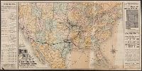
- Creator:
- George F. Cram Company
- Published / Created:
- 1873
- Call Number:
- 75 1873
- Container / Volume:
- BRBL_00405
- Image Count:
- 2
- Resource Type:
- Maps, Atlases & Globes
- Found in:
- Beinecke Rare Book and Manuscript Library > The Improved American Union Railroad map of the United States, British provinces, West Indies, Mexico and Central America.
- Creator:
- Rand McNally and Company
- Published / Created:
- [1882]
- Call Number:
- 75gme 1882B
- Container / Volume:
- BRBL_00413
- Image Count:
- 2
- Resource Type:
- Maps, Atlases & Globes
- Found in:
- Beinecke Rare Book and Manuscript Library > A correct map of the United States of America showing the Atchison, Topeka and Santa Fe R.R. and connections.
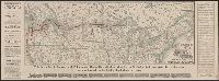
- Creator:
- Allen, Lane & Scott
- Published / Created:
- 1880
- Call Number:
- 75gme 1880B
- Container / Volume:
- BRBL_00413
- Image Count:
- 2
- Resource Type:
- Maps, Atlases & Globes
- Found in:
- Beinecke Rare Book and Manuscript Library > Pennsylvania Railroad : Great Trunk Line and U.S. Mail Route.
- Creator:
- Burr, Henry A
- Published / Created:
- 1850
- Call Number:
- 75 1850
- Container / Volume:
- BRBL_00400
- Image Count:
- 2
- Resource Type:
- Maps, Atlases & Globes
- Found in:
- Beinecke Rare Book and Manuscript Library > Disturnell's new map of the United States and Canada : showing all the canals, rail roads, telegraph lines and principal stage routes / drawn by Henry A. Burr, topographer to the Post Office Dep't., Washington, D.C. ; engraved by J.M. Atwood, N.Y.
- Creator:
- Young, J. H. (James Hamilton)
- Published / Created:
- [1864]
- Call Number:
- 75 1864B
- Container / Volume:
- BRBL_00403
- Image Count:
- 2
- Resource Type:
- Maps, Atlases & Globes
- Found in:
- Beinecke Rare Book and Manuscript Library > A new map of the United States of America [cartographic material] / by J.H. Young ; engraved by J.L. Hazzard & E. Yeager.
- Creator:
- Thomas, G. F
- Published / Created:
- [1864]
- Call Number:
- 75gme 1864
- Container / Volume:
- BRBL_00412
- Image Count:
- 2
- Resource Type:
- Maps, Atlases & Globes
- Found in:
- Beinecke Rare Book and Manuscript Library > Appletons' railway map of the United States and the Canadas : representing railways in actual operation, and those in course of construction, also map of the territories, showing the Pacific Railroad, gold regions, &c. / carefully compiled by G. F. Thomas
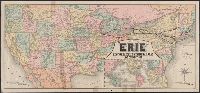
- Creator:
- Rand McNally and Company
- Published / Created:
- 1883
- Call Number:
- 75gme 1883
- Container / Volume:
- BRBL_00413
- Image Count:
- 2
- Resource Type:
- Maps, Atlases & Globes
- Found in:
- Beinecke Rare Book and Manuscript Library > Map of the "Erie" : New-York, Lake Erie and Western Rail Road and connections.
- Creator:
- Rand McNally and Company
- Published / Created:
- (Chicago : and [1886], c1883
- Call Number:
- 75gme 1883B
- Container / Volume:
- BRBL_00413
- Image Count:
- 2
- Resource Type:
- Maps, Atlases & Globes
- Found in:
- Beinecke Rare Book and Manuscript Library > Map of the South West railway system : Missouri Pacific Ry., Central Branch U.P.R.R., Missouri, Kansas & Texas Ry., Texas and Pacific Ry., St. Louis, Iron Mountn. and Southern Ry., International and Great Northern Ry. and their connections / Rand McNally
- Creator:
- Northern Pacific Railroad Company
- Published / Created:
- 1883
- Call Number:
- 75gme 1883E
- Container / Volume:
- BRBL_00413
- Image Count:
- 2
- Resource Type:
- Maps, Atlases & Globes
- Found in:
- Beinecke Rare Book and Manuscript Library > New and correct map of the lines of the Northern Pacific Railroad and Oregon Railway & Navigation Co.
- Creator:
- Steiger, W. T
- Published / Created:
- 1854
- Call Number:
- 75gme 1854
- Container / Volume:
- BRBL_00411
- Image Count:
- 2
- Resource Type:
- Maps, Atlases & Globes
- Found in:
- Beinecke Rare Book and Manuscript Library > Diagram of the United States of America, Mexico, the West India Islands and Isthmus of Darien : showing proposed routes of the Pacific Rail Road ... / by W. T. Steiger, General Land Office ; Lith. by A. Hoen & Co. Baltimore.
- Creator:
- Rand McNally and Company
- Published / Created:
- c1889.
- Call Number:
- 75gme 1889
- Container / Volume:
- BRBL_00414
- Image Count:
- 2
- Resource Type:
- Maps, Atlases & Globes
- Found in:
- Beinecke Rare Book and Manuscript Library > Rand McNally & Co.'s new official railroad map of the United States, Canada, and Mexico.
- Creator:
- Thomas, G. F
- Published / Created:
- [1876]
- Call Number:
- 754gme 1876
- Container / Volume:
- BRBL_00420
- Image Count:
- 2
- Resource Type:
- Maps, Atlases & Globes
- Found in:
- Beinecke Rare Book and Manuscript Library > Appletons' railway map of the United States and the Canadas : representing railways in actual operation, and those in course of construction, also map of the territories, showing the Pacific Railroad, gold regions, &c. / carefully compiled by G. F. Thomas
- Creator:
- Allen, Lane & Scott
- Published / Created:
- 1884
- Call Number:
- 75gme 1884
- Container / Volume:
- BRBL_00414
- Image Count:
- 2
- Resource Type:
- Maps, Atlases & Globes
- Found in:
- Beinecke Rare Book and Manuscript Library > Pennsylvania Railroad : Great Trunk Line of the United States / Chas. E. Pugh, General Manager ; J.R. Wood, General Passenger Agent.
- Creator:
- Rand McNally and Company
- Published / Created:
- 1891, c1889.
- Call Number:
- 75gme 1891
- Container / Volume:
- BRBL_00414
- Image Count:
- 2
- Resource Type:
- Maps, Atlases & Globes
- Found in:
- Beinecke Rare Book and Manuscript Library > Rand McNally & Co.'s new official railroad map of the United States, Canada, and Mexico.
- Creator:
- Northern Pacific Railroad Company
- Published / Created:
- 1883
- Call Number:
- 75gme 1883D
- Container / Volume:
- BRBL_00413
- Image Count:
- 2
- Resource Type:
- Maps, Atlases & Globes
- Found in:
- Beinecke Rare Book and Manuscript Library > New and correct map of the lines of the Northern Pacific Railroad and Oregon Railway & Navigation Co.
- Creator:
- Taylor, George Rogers, 1895-1983
- Published / Created:
- c1956.
- Call Number:
- 753gme 1861
- Container / Volume:
- BRBL_00415
- Image Count:
- 3
- Resource Type:
- Maps, Atlases & Globes
- Found in:
- Beinecke Rare Book and Manuscript Library > United States and Canadian railways, April 1, 1861 / compiled by George Rogers Taylor ; Robert L. Williams, map maker.
- Creator:
- National Railway Publication Company
- Published / Created:
- [187-?]
- Call Number:
- 71gme 1875
- Container / Volume:
- BRBL_00372
- Image Count:
- 1
- Resource Type:
- Maps, Atlases & Globes
- Found in:
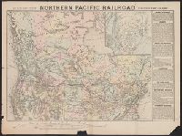
- Beinecke Rare Book and Manuscript Library > Map of the Northern Pacific R.R., its connections and tributary country.
- Published / Created:
- [1870?]
- Call Number:
- 75gme 1870
- Container / Volume:
- BRBL_00372
- Image Count:
- 1
- Resource Type:
- Maps, Atlases & Globes
- Found in:
- Beinecke Rare Book and Manuscript Library > Map showing the location of the Northern Pacific Rail Road.
- Creator:
- National Railway Publication Company
- Call Number:
- 71gme 1870
- Container / Volume:
- BRBL_00372
- Image Count:
- 1
- Resource Type:
- Maps, Atlases & Globes
- Found in:
- Beinecke Rare Book and Manuscript Library > Map of the Northern Pacific Railway and tributary country.
- Creator:
- National Railway Publication Company
- Published / Created:
- [1872?]
- Call Number:
- 71gme 1872
- Container / Volume:
- BRBL_00372
- Image Count:
- 1
- Resource Type:
- Maps, Atlases & Globes
- Found in:
- Beinecke Rare Book and Manuscript Library > Map of the Northern Pacific Railroad and tributary country.