Search
You Searched For
Search Results
- Published / Created:
- 1884]
- Call Number:
- 32ex Ab97 1884
- Container / Volume:
- BRBL_00075
- Image Count:
- 4
- Resource Type:
- Maps, Atlases & Globes
- Found in:
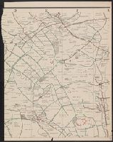
- Beinecke Rare Book and Manuscript Library > [Map of one hundred square miles round Abury; showing the British and Roman Stone and Earthworks of the Downs of North Wilts; by the Rev. A.C. Smith.
- Published / Created:
- 1777]
- Call Number:
- 755 1777F
- Container / Volume:
- BRBL_00431
- Image Count:
- 1
- Resource Type:
- Maps, Atlases & Globes
- Found in:
- Beinecke Rare Book and Manuscript Library > The British Colonies in North America. Engraved by William Faden.
- Creator:
- Aitken, Robert, 1735-1802
- Published / Created:
- 1775]
- Call Number:
- 764 B65 1775N
- Container / Volume:
- BRBL_00455
- Image Count:
- 1
- Resource Type:
- Maps, Atlases & Globes
- Found in:
- Beinecke Rare Book and Manuscript Library > A new and correct plan of the town of Boston.
- Published / Created:
- 1775]
- Call Number:
- 764 B65 1775H
- Container / Volume:
- BRBL_00454
- Image Count:
- 1
- Resource Type:
- Maps, Atlases & Globes
- Found in:
- Beinecke Rare Book and Manuscript Library > A plan of the town and chart of the harbour of Boston : exhibiting a view of the islands, castle forts, and entrances into the said harbour.
- Published / Created:
- 1758]
- Call Number:
- 771hc T43 1758
- Container / Volume:
- BRBL_00495
- Image Count:
- 1
- Resource Type:
- Maps, Atlases & Globes
- Found in:
- Beinecke Rare Book and Manuscript Library > The attack of Ticonderoga; Major General Abercrombie Commander in Chief.
- Published / Created:
- 1841 [i.e. 1842]
- Call Number:
- 796fab 1842
- Container / Volume:
- BRBL_00530
- Image Count:
- 1
- Resource Type:
- Maps, Atlases & Globes
- Found in:
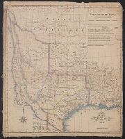
- Beinecke Rare Book and Manuscript Library > A new map of Texas / Day & Haghe, lith.rs to the Queen.
- Published / Created:
- 1671]
- Call Number:
- 97 1671
- Container / Volume:
- BRBL_00677
- Image Count:
- 1
- Resource Type:
- Maps, Atlases & Globes
- Found in:
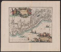
- Beinecke Rare Book and Manuscript Library > Perv [by William Blaeu, adapted by Jacob van Meurs].
- Creator:
- Gibson, J. (John)
- Published / Created:
- 1763]
- Call Number:
- 71 1763G
- Container / Volume:
- BRBL_00726
- Image Count:
- 1
- Resource Type:
- Maps, Atlases & Globes
- Found in:
- Beinecke Rare Book and Manuscript Library > The British governments in Nth. America [cartographic material] : laid down agreeable to the proclamation of Octr. 7, 1763 / J. Gibson sculp.
- Published / Created:
- 1783
- Call Number:
- 755 1783B
- Container / Volume:
- BRBL_00434
- Image Count:
- 1
- Resource Type:
- Maps, Atlases & Globes
- Found in:
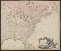
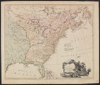
- Beinecke Rare Book and Manuscript Library > The United States of North America, with the British & Spanish Territories, according to the treaty. Engraved by Wm. Faden.
- Creator:
- Moll, Herman, d. 1732
- Call Number:
- 85 1745A
- Container / Volume:
- BRBL_00636
- Image Count:
- 1
- Resource Type:
- Maps, Atlases & Globes
- Found in:
- Beinecke Rare Book and Manuscript Library > A chart of ye West-Indies or the islands of America in the North Sea &c., being ye present seat of war / by Herman Moll, geographer.
- Creator:
- Senex, John, d. 1740
- Published / Created:
- 1720]
- Call Number:
- 11 1720B
- Container / Volume:
- BRBL_00680
- Image Count:
- 1
- Resource Type:
- Maps, Atlases & Globes
- Found in:
- Beinecke Rare Book and Manuscript Library > A new map of the world [cartographic material] : from the latest observations / revised by I. Senex.
- Creator:
- Melish, John, 1771-1822
- Published / Created:
- 1824]
- Call Number:
- 75 1824
- Container / Volume:
- BRBL_00398
- Image Count:
- 1
- Resource Type:
- Maps, Atlases & Globes
- Found in:
- Beinecke Rare Book and Manuscript Library > United States of America, compiled from the latest and best authorities / by John Melish ; engraved by Sidy. Hall, Bury Strt. Bloomsby.
- Creator:
- Kitchin, Thomas, d. 1784
- Published / Created:
- 1766?]
- Call Number:
- 755 1763A
- Container / Volume:
- BRBL_00428
- Image Count:
- 1
- Resource Type:
- Maps, Atlases & Globes
- Found in:
- Beinecke Rare Book and Manuscript Library > A new and accurate map of the British dominions in America, according to the Treaty of 1763, divided into the several provinces and jurisdictions : projected upon the best authorities and astronomical observations / by Thos. Kitchin, geographer.
- Creator:
- Senex, John, d. 1740
- Published / Created:
- 1712]
- Call Number:
- 501 1710
- Container / Volume:
- BRBL_00684
- Image Count:
- 1
- Resource Type:
- Maps, Atlases & Globes
- Found in:
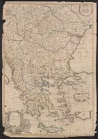
- Beinecke Rare Book and Manuscript Library > Turky in Europe : corrected from observations communicated to the Royal Society at London and Paris. / by Iohn Senex.
- Creator:
- Senex, John, d. 1740
- Published / Created:
- 1712
- Call Number:
- 352 1712
- Container / Volume:
- BRBL_00683
- Image Count:
- 1
- Resource Type:
- Maps, Atlases & Globes
- Found in:
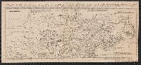
- Beinecke Rare Book and Manuscript Library > Moscovy : corrected from ye observations communicated to the Royal Society of London and Paris / by Iohn Senex ...
- Creator:
- Senex, John, d. 1740
- Published / Created:
- 1712]
- Call Number:
- 501 1710
- Container / Volume:
- BRBL_00684
- Image Count:
- 1
- Resource Type:
- Maps, Atlases & Globes
- Found in:
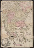
- Beinecke Rare Book and Manuscript Library > Turky in Europe : corrected from observations communicated to the Royal Society at London and Paris. / by Iohn Senex.
- Creator:
- Senex, John, d. 1740
- Published / Created:
- 1710?]
- Call Number:
- 39 1710
- Container / Volume:
- BRBL_00684
- Image Count:
- 1
- Resource Type:
- Maps, Atlases & Globes
- Found in:
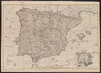
- Beinecke Rare Book and Manuscript Library > A correct map of Spain & Portugal : according to the newest observations and discoveries communicated to the Royal Society at London and the Royal Academy at Paris ... / I. Senex ...
- Creator:
- Senex, John, d. 1740
- Published / Created:
- 1710
- Call Number:
- 341 1710A
- Container / Volume:
- BRBL_00683
- Image Count:
- 1
- Resource Type:
- Maps, Atlases & Globes
- Found in:
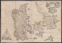
- Beinecke Rare Book and Manuscript Library > Denmark [cartographic material] : corrected from the newest observations of the Royal Societeies at London and Paris. / by I. Senex ...
- Creator:
- Senex, John, d. 1740
- Published / Created:
- 1710
- Call Number:
- 33 1710
- Container / Volume:
- BRBL_00683
- Image Count:
- 1
- Resource Type:
- Maps, Atlases & Globes
- Found in:
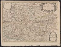
- Beinecke Rare Book and Manuscript Library > A new map of the provinces of Hainault, Namur and Cambray / by Iohn Senex, F.R.S.
- Published / Created:
- 1763
- Call Number:
- 19 1763
- Container / Volume:
- BRBL_00682
- Image Count:
- 1
- Resource Type:
- Maps, Atlases & Globes
- Found in:
- Beinecke Rare Book and Manuscript Library > Chart of the Antarctic Polar Circle, with the countries adjoining : according to a new hypothesis of M. Buache, from the memoirs of the Royal Academy at Paris.
- Creator:
- Kitchin, Thomas, d. 1784
- Published / Created:
- 1760?]
- Call Number:
- 11 1755A
- Container / Volume:
- BRBL_00681
- Image Count:
- 1
- Resource Type:
- Maps, Atlases & Globes
- Found in:
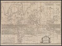
- Beinecke Rare Book and Manuscript Library > An accurate chart of the world with the new discoveries [cartographic material] : also a view of the general and coasting trade winds, monsoons or shifting trade winds and the variations of the compass, from the latest and best authorities / by T. Kitchen
- Creator:
- Senex, John, d. 1740
- Published / Created:
- 1725?]
- Call Number:
- 30 1720B
- Container / Volume:
- BRBL_00683
- Image Count:
- 1
- Resource Type:
- Maps, Atlases & Globes
- Found in:
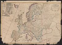
- Beinecke Rare Book and Manuscript Library > Europe [cartographic material] : corrected from the observation communicated to the Royal Society at London and the Royal Academy at Paris. / by Ion Senex ...
- Creator:
- L'Isle, Guillaume de, 1675-1726
- Published / Created:
- 1720?]
- Call Number:
- 49 1740
- Container / Volume:
- BRBL_00684
- Image Count:
- 1
- Resource Type:
- Maps, Atlases & Globes
- Found in:
- Beinecke Rare Book and Manuscript Library > In notitiam ecclesiasticam Africae tabula geographica / auctore G. De L'Isle ...
- Creator:
- Senex, John, d. 1740
- Published / Created:
- 1708
- Call Number:
- 40 1708
- Container / Volume:
- BRBL_00684
- Image Count:
- 1
- Resource Type:
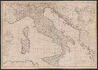
- Maps, Atlases & Globes
- Found in:
- Beinecke Rare Book and Manuscript Library > A new map of Italy : corrected from the observations communicated to ye Royal Society at london and ye Royal Accademy [sic] at Paris / by Iohn Senex.
- Creator:
- Senex, John, d. 1740
- Published / Created:
- 1708?]
- Call Number:
- 345 1720
- Container / Volume:
- BRBL_00683
- Image Count:
- 1
- Resource Type:
- Maps, Atlases & Globes
- Found in:
- Beinecke Rare Book and Manuscript Library > Sweden [cartographic material] : corrected from the observations communicated to the Roayl Society at London and the Royal Academy at Paris / by Iohn Senex ...
- Creator:
- Senex, John, d. 1740
- Published / Created:
- 1712]
- Call Number:
- 356 1710
- Container / Volume:
- BRBL_00683
- Image Count:
- 1
- Resource Type:
- Maps, Atlases & Globes
- Found in:
- Beinecke Rare Book and Manuscript Library > Poland [cartographic material] : corrected from the observations communicated to the Royal Society at London and the Royal Academy at Paris / ... by Iohn Senex.
- Creator:
- Senex, John, -1740
- Published / Created:
- 1710
- Call Number:
- 36 1710
- Container / Volume:
- BRBL_00683
- Image Count:
- 1
- Resource Type:
- Maps, Atlases & Globes
- Found in:
- Beinecke Rare Book and Manuscript Library > Germany [cartographic material] : corrected from the observations of the Royal Society at London and the Royal Academy at Paris / by John Senex ...
- Creator:
- Bowen, Thomas, d. 1790
- Published / Created:
- 1755]
- Call Number:
- 71 1755E
- Container / Volume:
- BRBL_00687
- Image Count:
- 1
- Resource Type:
- Maps, Atlases & Globes
- Found in:
- Beinecke Rare Book and Manuscript Library > A map of the British and French settlements in North America / T. Bowen, sculpt[or].
- Published / Created:
- 1775]
- Call Number:
- 76 1740
- Container / Volume:
- BRBL_00690
- Image Count:
- 1
- Resource Type:
- Maps, Atlases & Globes
- Found in:
- Beinecke Rare Book and Manuscript Library > A map of 100 miles round Boston [cartographic material].
- Published / Created:
- 1755]
- Call Number:
- 755 1755A
- Container / Volume:
- BRBL_00690
- Image Count:
- 1
- Resource Type:
- Maps, Atlases & Globes
- Found in:
- Beinecke Rare Book and Manuscript Library > A map of the British & French Plantations in North America.
- Creator:
- Bowen, Emanuel, d. 1767
- Published / Created:
- 1754
- Call Number:
- 75 1720
- Container / Volume:
- BRBL_00689
- Image Count:
- 1
- Resource Type:
- Maps, Atlases & Globes
- Found in:
- Beinecke Rare Book and Manuscript Library > A map of the British American plantations [cartographic material] : extending from Boston in New England to Georgia, including all the back settlements in the respective provinces, as far as the Mississippi / by Eman. Bowen Geogr. to His Majesty ; Tho. Bo
- Published / Created:
- 1776]
- Call Number:
- 766 1776
- Container / Volume:
- BRBL_00690
- Image Count:
- 1
- Resource Type:
- Maps, Atlases & Globes
- Found in:
- Beinecke Rare Book and Manuscript Library > A map of Connecticut and Rhode Island with Long Island Sound, &c.
- Published / Created:
- 1759]
- Call Number:
- 734 Q31 1759
- Container / Volume:
- BRBL_00689
- Image Count:
- 1
- Resource Type:
- Maps, Atlases & Globes
- Found in:
- Beinecke Rare Book and Manuscript Library > A plan of Quebec : metropolis of Canada in North America.
- Creator:
- Gibson, J. (John)
- Published / Created:
- 1763]
- Call Number:
- 75 1778
- Collection Title:
- Gentleman's magazine.
- Container / Volume:
- BRBL_00689
- Image Count:
- 1
- Resource Type:
- Maps, Atlases & Globes
- Found in:
- Beinecke Rare Book and Manuscript Library > [Map of Louisiana and the western parts of Virginia and Carolina] / [cartographic material] / J. Gibson, sculp.
- Published / Created:
- 1776]
- Call Number:
- 766 1776
- Container / Volume:
- BRBL_00690
- Image Count:
- 1
- Resource Type:
- Maps, Atlases & Globes
- Found in:
- Beinecke Rare Book and Manuscript Library > A map of Connecticut and Rhode Island with Long Island Sound, &c.
- Published / Created:
- 1755]
- Call Number:
- 755 1755Q
- Container / Volume:
- BRBL_00690
- Image Count:
- 1
- Resource Type:
- Maps, Atlases & Globes
- Found in:
- Beinecke Rare Book and Manuscript Library > A map of the five Great Lakes with part of Pensilvania, New York, Canada and Hudsons Bay territories &c [cartographic material].
- Published / Created:
- 1780]
- Call Number:
- 773 1778D
- Container / Volume:
- BRBL_00690
- Image Count:
- 1
- Resource Type:
- Maps, Atlases & Globes
- Found in:
- Beinecke Rare Book and Manuscript Library > A new and accurate map of New Jersey [cartographic material] : from the best authorities.
- Creator:
- Gibson, J. (John)
- Published / Created:
- 1762]
- Call Number:
- 8555 1762
- Container / Volume:
- BRBL_00695
- Image Count:
- 1
- Resource Type:
- Maps, Atlases & Globes
- Found in:
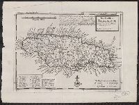
- Beinecke Rare Book and Manuscript Library > A map of the Island of Jamaica [cartographic material] / J. Gibson sculpt.
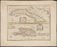
- Creator:
- Bowen, Emanuel, d. 1767
- Published / Created:
- 1747]
- Call Number:
- 855 1747
- Container / Volume:
- BRBL_00695
- Image Count:
- 1
- Resource Type:
- Maps, Atlases & Globes
- Found in:
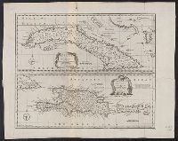
- Beinecke Rare Book and Manuscript Library > A new & accurate map of the island of Cuba ; A new & accurate map of the islands of Hispaniola or St. Domingo, and Porto Rico / [cartographic material] / drawn from the most approved maps & charts, and regulated by astronl. observations by Eman. Bowen.
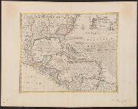
- Published / Created:
- 1780]
- Call Number:
- 85 1740
- Container / Volume:
- BRBL_00693
- Image Count:
- 1
- Resource Type:
- Maps, Atlases & Globes
- Found in:
- Beinecke Rare Book and Manuscript Library > West Indies [cartographic material] : with the harbour & fort of Omoa from the best authorities.
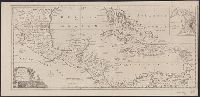
- Creator:
- Kitchin, Thomas, d. 1784
- Published / Created:
- 1762]
- Call Number:
- 85 1760
- Container / Volume:
- BRBL_00693
- Image Count:
- 1
- Resource Type:
- Maps, Atlases & Globes
- Found in:
- Beinecke Rare Book and Manuscript Library > A new and correct map of the American Islands : now called the West Indies, with the whole coast of the neighbouring continent / by Thos. Kitchin geogr.
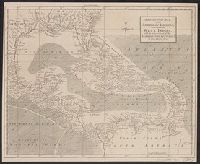
- Creator:
- Bowen, Emanuel, d. 1767
- Published / Created:
- 1747]
- Call Number:
- 85 1730A
- Container / Volume:
- BRBL_00692
- Image Count:
- 1
- Resource Type:
- Maps, Atlases & Globes
- Found in:
- Beinecke Rare Book and Manuscript Library > An accurate map of the West Indies [cartographic material] : drawn from the best authorities, assisted by the most approved modern maps and charts, and regulated by astronomical observations / by Eman: Bowen.
- Creator:
- Moll, Herman, d. 1732
- Published / Created:
- 1728]
- Call Number:
- 8555 1728
- Container / Volume:
- BRBL_00695
- Image Count:
- 1
- Resource Type:
- Maps, Atlases & Globes
- Found in:
- Beinecke Rare Book and Manuscript Library > The island of Jamaica, divided into its principal parishes, with the roads &c. / [cartographic material] / by H. Moll, geographer.
- Creator:
- Bowen, Emanuel, d. 1767
- Published / Created:
- 1747]
- Call Number:
- 867 1747
- Container / Volume:
- BRBL_00696
- Image Count:
- 1
- Resource Type:
- Maps, Atlases & Globes
- Found in:
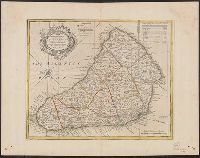
- Beinecke Rare Book and Manuscript Library > An accurate map of the island of Barbadoes [cartographic material] : drawn from an actual survey containing all the towns, churches, fortifications, roads, paths, plantations &c. / by Eman. Bowen.
- Published / Created:
- 1776]
- Call Number:
- 755 1776R
- Container / Volume:
- BRBL_00728
- Image Count:
- 1
- Resource Type:
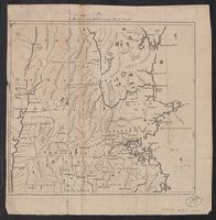
- Maps, Atlases & Globes
- Found in:
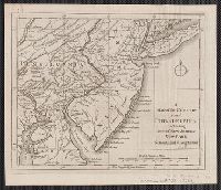
- Beinecke Rare Book and Manuscript Library > A map of the country round Philadelphia : including part of New Jersey, New York, Staten Island & Long Island.
- Creator:
- Bowen, Emanuel, d. 1767
- Published / Created:
- 1750?]
- Call Number:
- 855 1750
- Container / Volume:
- BRBL_00641
- Image Count:
- 1
- Resource Type:
- Maps, Atlases & Globes
- Found in:
- Beinecke Rare Book and Manuscript Library > A new & accurate map of the island of Cuba ; A new & accurate map of the islands of Hispaniola or St. Domingo, and Porto Rico / [cartographic material] / drawn from the most approved maps & charts, and regulated by astronl. observations by Eman. Bowen.
- Published / Created:
- 1924
- Call Number:
- 32cea 1856
- Container / Volume:
- BRBL_00075
- Image Count:
- 1
- Resource Type:
- Maps, Atlases & Globes
- Found in:
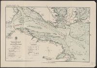
- Beinecke Rare Book and Manuscript Library > Plan of Spithead : showing the proposed evolutions at the review of the fleet by Her Majesty on Wednesday the 23rd april 1856.
- Published / Created:
- 1671]
- Call Number:
- 902 1671
- Container / Volume:
- BRBL_00665
- Image Count:
- 1
- Resource Type:
- Maps, Atlases & Globes
- Found in:
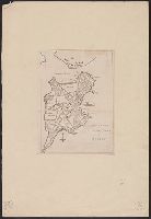
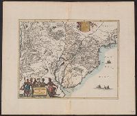
- Beinecke Rare Book and Manuscript Library > Terra firma et novum regnum Granatense et Popayan.
- Published / Created:
- 1671]
- Call Number:
- 919 1671
- Container / Volume:
- BRBL_00673
- Image Count:
- 1
- Resource Type:
- Maps, Atlases & Globes
- Found in:
- Beinecke Rare Book and Manuscript Library > Paraqvaria, vulgo Paragvay. Cum adjacentibus.
- Creator:
- Bolton, Solomon, d. ca. 1768
- Published / Created:
- 1766]
- Call Number:
- 71 1766B
- Container / Volume:
- BRBL_00364
- Image Count:
- 4
- Resource Type:
- Maps, Atlases & Globes
- Found in:
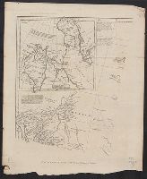
- Beinecke Rare Book and Manuscript Library > North America : performed under the patronage of Louis Duke of Orleans, First Prince of the Blood / by the Sieur d'Anville, greatly improved by Mr. Bolton ; engraved by R.W. Seale ; Gravelot, delin. ; Walker, sculp.