Search
You Searched For
Search Results
- Creator:
- Alcott, Amos Bronson, 1799-1888
- Published / Created:
- 1836-1837.
- Call Number:
- Za AL18 836c
- Image Count:
- 12
- Resource Type:
- Books, Journals & Pamphlets
- Found in:
- Beinecke Rare Book and Manuscript Library > Conversations with children on the Gospels / conducted and edited by A. Bronson Alcott. Volume I[-II].
- Creator:
- Banvard, Joseph, 1810-1887, author
- Published / Created:
- 1839
- Call Number:
- Zm C887
- Image Count:
- 12
- Found in:
- Beinecke Rare Book and Manuscript Library > Cruel Jack.
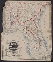
- Creator:
- Geo. W. Stadly & Co
- Published / Created:
- [186-?]
- Call Number:
- 754hc 1862C
- Container / Volume:
- BRBL_00421
- Image Count:
- 13
- Resource Type:
- Maps, Atlases & Globes
- Found in:
- Beinecke Rare Book and Manuscript Library > [13 maps showing positions of the Union and Confederate armies during the year 1862] / drawn and printed by Geo. W. Stadly & Co.
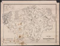
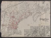
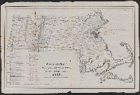
- Creator:
- Walling, Henry Francis, 1825-1888
- Published / Created:
- 1858
- Call Number:
- 764 B45 1858
- Container / Volume:
- BRBL_00454
- Image Count:
- 6
- Resource Type:
- Maps, Atlases & Globes
- Found in:
- Beinecke Rare Book and Manuscript Library > Map of the county of Berkshire, Massachusetts : based upon the trigonometrical survey of the state / the details from actual surveys under the direction of Henry F. Walling, supt. of the state map.
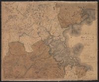
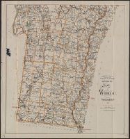
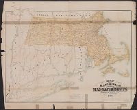
- Creator:
- Walling, Henry Francis, 1825-1888
- Published / Created:
- 1858
- Call Number:
- 764 N76 1858
- Container / Volume:
- BRBL_00458
- Image Count:
- 6
- Resource Type:
- Maps, Atlases & Globes
- Found in:
- Beinecke Rare Book and Manuscript Library > Map of the county of Norfolk, Massachusetts / based upon the details of the trigonometrical survey of the state; the details from actual surveys under the direction of Henry F. Walling. Supt. of the state map.
- Published / Created:
- [1832?]
- Call Number:
- 764 B764 1832
- Container / Volume:
- BRBL_00456A
- Image Count:
- 1
- Resource Type:
- Maps, Atlases & Globes
- Found in:
- Beinecke Rare Book and Manuscript Library > Map of Bridgewater, Mass.
- Published / Created:
- 1800
- Call Number:
- 764 B65 1800
- Container / Volume:
- BRBL_00455
- Image Count:
- 1
- Resource Type:
- Maps, Atlases & Globes
- Found in:
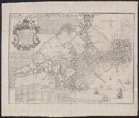
- Beinecke Rare Book and Manuscript Library > A new plan of Boston from Actual surveys by Osgood Carleton. With corrections, additions, & improvements.
- Published / Created:
- 1835
- Call Number:
- 764 B65 1835
- Container / Volume:
- BRBL_00455
- Image Count:
- 1
- Resource Type:
- Maps, Atlases & Globes
- Found in:
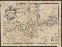
- Beinecke Rare Book and Manuscript Library > The South Cove territory, comprising every part which is coloured on this map.
- Published / Created:
- 1819
- Call Number:
- 764 B65 1819
- Container / Volume:
- BRBL_00455
- Image Count:
- 1
- Resource Type:
- Maps, Atlases & Globes
- Found in:
- Beinecke Rare Book and Manuscript Library > Map of Boston and its Vicinity by John G. Hales.
- Creator:
- E.P. Dutton (Firm)
- Published / Created:
- 1865
- Call Number:
- 764 B65 1865
- Container / Volume:
- BRBL_00455
- Image Count:
- 1
- Resource Type:
- Maps, Atlases & Globes
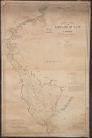
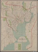
- Found in:
- Beinecke Rare Book and Manuscript Library > Chart of Boston Harbor and Massachusetts Bay : with map of the adjacent country / published at the Boston Map Store.
- Creator:
- Sampson, Murdock & Co
- Published / Created:
- [1886], c1885.
- Call Number:
- 764 B65 1886
- Container / Volume:
- BRBL_00456
- Image Count:
- 1
- Resource Type:
- Maps, Atlases & Globes
- Found in:
- Beinecke Rare Book and Manuscript Library > Map of Boston for 1886.
- Published / Created:
- [1831?]
- Call Number:
- 764 B63 1831
- Container / Volume:
- BRBL_00454
- Image Count:
- 1
- Resource Type:
- Maps, Atlases & Globes
- Found in:
- Beinecke Rare Book and Manuscript Library > A Map of the Town of Bolton in the County of Worcester and the Commonwealth of Massachusetts. Surveyed by Silas Holman in the Year 1831.
- Creator:
- Price, William, fl. 1725-1769
- Published / Created:
- [1743]
- Call Number:
- 764 B65 1743
- Container / Volume:
- BRBL_00454
- Image Count:
- 1
- Resource Type:
- Maps, Atlases & Globes
- Found in:
- Beinecke Rare Book and Manuscript Library > A new plan of ye great town of Boston in New England in America : with the many additionall buildings & new streets, to the year, 1743.
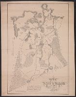
- Published / Created:
- 1893
- Call Number:
- 766 T57 1893
- Container / Volume:
- BRBL_00474
- Image Count:
- 1
- Resource Type:
- Maps, Atlases & Globes
- Found in:
- Beinecke Rare Book and Manuscript Library > Tolland [County].
- Creator:
- Federal Engraving and Publishing Co
- Published / Created:
- c1905.
- Call Number:
- 764am B65 1905
- Container / Volume:
- BRBL_00460
- Image Count:
- 1
- Resource Type:
- Maps, Atlases & Globes
- Found in:
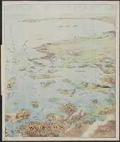
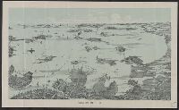
- Beinecke Rare Book and Manuscript Library > Bird's eye view of Boston Harbor and South Shore to Provincetown : showing steamboat routes.
- Creator:
- Hughes & Bailey
- Published / Created:
- [1919]
- Call Number:
- 766am Se96 1919
- Container / Volume:
- BRBL_00474
- Image Count:
- 1
- Resource Type:
- Maps, Atlases & Globes
- Found in:
- Beinecke Rare Book and Manuscript Library > Aero view of Seymour, Connecticut, 1919.
- Creator:
- Boardman, Harvey
- Published / Created:
- c1858.
- Call Number:
- 762 W588 1858
- Container / Volume:
- BRBL_00451
- Image Count:
- 1
- Resource Type:
- Maps, Atlases & Globes
- Found in:
- Beinecke Rare Book and Manuscript Library > Map of the White Mountains, New Hampshire : from original surveys / by Harvey Boardman, 1858 / engraved by Smith Knight & Tappan, Boston.
- Published / Created:
- 1879
- Call Number:
- 766am N46 1879V
- Container / Volume:
- BRBL_00474
- Image Count:
- 1
- Resource Type:
- Maps, Atlases & Globes
- Found in:
- Beinecke Rare Book and Manuscript Library > The city of New Haven, Conn.
- Creator:
- Walker Lith. & Pub. Co
- Published / Created:
- [1890?]
- Call Number:
- 764am B65 1890A
- Container / Volume:
- BRBL_00460
- Image Count:
- 1
- Resource Type:
- Maps, Atlases & Globes
- Found in:
- Beinecke Rare Book and Manuscript Library > Boston Harbor.
- Published / Created:
- 1887
- Call Number:
- 762 W588 1887
- Container / Volume:
- BRBL_00451
- Image Count:
- 1
- Resource Type:
- Maps, Atlases & Globes
- Found in:
- Beinecke Rare Book and Manuscript Library > Map of the White Mountains of New Hamshire.
- Creator:
- Bradley, Eliza, b. 1783.
- Published / Created:
- 1823
- Call Number:
- In B728 819F
- Image Count:
- 1
- Resource Type:
- Books, Journals & Pamphlets
- Found in:
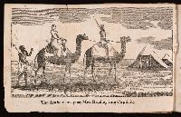
- Beinecke Rare Book and Manuscript Library > An authentic narrative of the shipwreck and sufferings of Mrs. Eliza Bradley, wife of Capt. James Bradley, of Liverpool, commander of the ship Sally, which was wrecked on the coast of Barbary, in June, 1818 / written by herself ...
- Creator:
- Dorman, Moses, author.
- Published / Created:
- 1830
- Call Number:
- 764 An23 1830
- Image Count:
- 1
- Resource Type:
- Maps, Atlases & Globes
- Found in:
- Beinecke Rare Book and Manuscript Library > A plan of Andover taken for the town / by Moses Dorman, Jr.
- Creator:
- Perkins, Frederic B. (Frederic Beecher), 1828-1899
- Published / Created:
- 1880
- Call Number:
- 75FCB 1880G
- Container / Volume:
- BRBL_00410
- Image Count:
- 1
- Resource Type:
- Maps, Atlases & Globes
- Found in:
- Beinecke Rare Book and Manuscript Library > Congressional district vote map of the United States / designed by Fred B. Perkins ; drawn by Whitman & Breck.
- Creator:
- Bouvé, Ephraim W., 1817-1897
- Published / Created:
- [185-?]
- Call Number:
- 754gme 1850A
- Container / Volume:
- BRBL_00419
- Image Count:
- 1
- Resource Type:
- Maps, Atlases & Globes
- Found in:
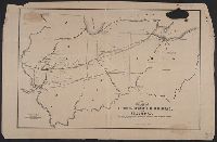
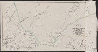
- Beinecke Rare Book and Manuscript Library > Map of the Alton & Springfield railroad, in Illinois : showing its connection with other roads and proposed roads leading to the eastern cities / lith. of E.W. Bouvé.
- Creator:
- National Publishing Company (Boston, Mass.)
- Published / Created:
- 1898
- Call Number:
- 76 1898
- Container / Volume:
- BRBL_00445
- Image Count:
- 1
- Resource Type:
- Maps, Atlases & Globes
- Found in:
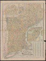
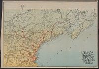
- Beinecke Rare Book and Manuscript Library > New post office, township, county and railroad map of New England : with distances.
- Published / Created:
- 1893
- Call Number:
- 776cea 1893
- Container / Volume:
- BRBL_00502
- Image Count:
- 1
- Resource Type:
- Maps, Atlases & Globes
- Found in:
- Beinecke Rare Book and Manuscript Library > Eldridge's Chart No. 11 : Delaware Bay and river / from the U.S. Coast and George Elridge's surveys.
- Published / Created:
- 1905
- Call Number:
- 762 1905
- Container / Volume:
- BRBL_00450
- Image Count:
- 1
- Resource Type:
- Maps, Atlases & Globes
- Found in:
- Beinecke Rare Book and Manuscript Library > Map of New Hampshire.
- Creator:
- Burwell, Elliot Noël
- Published / Created:
- c1907.
- Call Number:
- 762 W73 1907
- Container / Volume:
- BRBL_00451
- Image Count:
- 1
- Resource Type:
- Maps, Atlases & Globes
- Found in:
- Beinecke Rare Book and Manuscript Library > A map of Lake Winnipesaukee, New Hampshire / author, Elliot Noël Burwell.
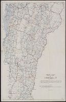
- Published / Created:
- 1912
- Call Number:
- 763gmb 1917
- Container / Volume:
- BRBL_00452
- Image Count:
- 1
- Resource Type:
- Maps, Atlases & Globes
- Found in:
- Beinecke Rare Book and Manuscript Library > Road map of Vermont.
- Creator:
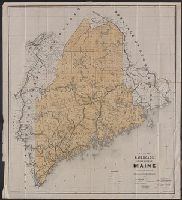
- Maine. Board of Railroad Commissioners
- Published / Created:
- c1891.
- Call Number:
- 761gme 1891
- Container / Volume:
- BRBL_00449
- Image Count:
- 1
- Resource Type:
- Maps, Atlases & Globes
- Found in:
- Beinecke Rare Book and Manuscript Library > Map of the railroads of the state of Maine accompanying the report of the railroad commissioners, 1892 / prepared for the Board of Railroad Commissioners under the direction of William A. Allen ; H.C. Robinson, E.A. Boothby, draughtsmen.
- Creator:
- Automobile Club of America, cartographer.
- Published / Created:
- [1908]
- Call Number:
- 762gmb 1908
- Container / Volume:
- BRBL_00451
- Image Count:
- 1
- Resource Type:
- Maps, Atlases & Globes
- Found in:
- Beinecke Rare Book and Manuscript Library > Automobile map of New Hampshire / Automobile Club of America.
- Creator:
- Walker Lith. & Pub. Co
- Published / Created:
- 1912
- Call Number:
- 763 1912
- Container / Volume:
- BRBL_00452
- Image Count:
- 1
- Resource Type:
- Maps, Atlases & Globes
- Found in:
- Beinecke Rare Book and Manuscript Library > Road map of Vermont showing the selected highways, state roads, which are being improved and maintained under state supervision in accordance with Chapters 172 and 176 P.S. / Issued in connection with the Biennial Report of the State Highway Commissioner
- Published / Created:
- [186-]
- Call Number:
- 754gme 1867
- Container / Volume:
- BRBL_00420
- Image Count:
- 1
- Resource Type:
- Maps, Atlases & Globes
- Found in:
- Beinecke Rare Book and Manuscript Library > Map of the Boston, Hartford & Erie Rail Road.
- Creator:
- Rand Avery Supply Co
- Published / Created:
- [ca 1900?]
- Call Number:
- 754gme 1900
- Container / Volume:
- BRBL_00420
- Image Count:
- 1
- Resource Type:
- Maps, Atlases & Globes
- Found in:
- Beinecke Rare Book and Manuscript Library > Map of the Charleston & Savannah Ry., Savannah Florida & Western Ry., South Florida Ry. : and all of the routes operated by the peoples line of steamers and plant steamship line known as the plant system / Rand Avery Supply Co.
- Creator:
- Rand Avery Supply Co
- Published / Created:
- [1911?]
- Call Number:
- 76gme 1910
- Container / Volume:
- BRBL_00446A
- Image Count:
- 1
- Resource Type:
- Maps, Atlases & Globes
- Found in:
- Beinecke Rare Book and Manuscript Library > Boston & Maine Railroad and connections / Rand Avery Supply Co.
- Creator:
- Geo. H. Walker & Co
- Published / Created:
- c1909.
- Call Number:
- 761 R16 1909
- Container / Volume:
- BRBL_00449
- Image Count:
- 1
- Resource Type:
- Maps, Atlases & Globes
- Found in:
- Beinecke Rare Book and Manuscript Library > Map of Maine : Rangeley and Megantic district / published by Walker Lithograph & Publishing Co.
- Published / Created:
- 1909
- Call Number:
- 763gmb 1909
- Container / Volume:
- BRBL_00452
- Image Count:
- 1
- Resource Type:
- Maps, Atlases & Globes
- Found in:
- Beinecke Rare Book and Manuscript Library > Southern Part, Map of Vermont.
- Creator:
- Geo. H. Walker & Co
- Published / Created:
- 1903, c1893.
- Call Number:
- 762 1903
- Container / Volume:
- BRBL_00450
- Image Count:
- 1
- Resource Type:
- Maps, Atlases & Globes
- Found in:
- Beinecke Rare Book and Manuscript Library > Map of New Hampshire, southern part : cycling routes shown in red / by Geo. H. Walker & Co.
- Creator:
- Hill, A. B
- Published / Created:
- c1896.
- Call Number:
- 766 N46 1896A
- Container / Volume:
- BRBL_00473
- Image Count:
- 1
- Resource Type:
- Maps, Atlases & Globes
- Found in:
- Beinecke Rare Book and Manuscript Library > City of New Haven, Connecticut / A.B. Hill ; engraved by Geo. H. Walker & Co.
- Creator:
- Hill, A. B., civil engineer
- Published / Created:
- c1893.
- Call Number:
- 766 N46 1893J
- Container / Volume:
- BRBL_00473
- Image Count:
- 1
- Resource Type:
- Maps, Atlases & Globes
- Found in:
- Beinecke Rare Book and Manuscript Library > City of New Haven, Connecticut / A.B. Hill, c.e.
- Published / Created:
- 1893
- Call Number:
- 766 W72 1893
- Container / Volume:
- BRBL_00474
- Image Count:
- 1
- Resource Type:
- Maps, Atlases & Globes
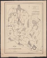
- Found in:
- Beinecke Rare Book and Manuscript Library > Windham County
- Published / Created:
- 1900
- Call Number:
- 771 Ad47 1900
- Container / Volume:
- BRBL_00480
- Image Count:
- 1
- Resource Type:
- Maps, Atlases & Globes
- Found in:
- Beinecke Rare Book and Manuscript Library > Map of the Adirondack Region, southern part.
- Published / Created:
- 1743-1745.
- Call Number:
- Mye500 U2 C462
- Image Count:
- 1
- Resource Type:
- Books, Journals & Pamphlets
- Found in:
- Beinecke Rare Book and Manuscript Library > The Christian history.
- Published / Created:
- 1830
- Call Number:
- 764 C74 1830
- Container / Volume:
- BRBL_00456A
- Image Count:
- 1
- Resource Type:
- Maps, Atlases & Globes
- Found in:
- Beinecke Rare Book and Manuscript Library > Plan of the Town of Concord, Mass. Surveyed by John G. Hales
- Published / Created:
- [1831?]
- Call Number:
- 764 D728 1831
- Container / Volume:
- BRBL_00457
- Image Count:
- 1
- Resource Type:
- Maps, Atlases & Globes
- Found in:
- Beinecke Rare Book and Manuscript Library > Map of the towns of Dorchester and Milton, 1831. Edmund J. Baker.
- Creator:
- Walling, Henry Francis, 1825-1888
- Published / Created:
- 1869
- Call Number:
- 764 B65 1869
- Container / Volume:
- BRBL_00455
- Image Count:
- 1
- Resource Type:
- Maps, Atlases & Globes
- Found in:
- Beinecke Rare Book and Manuscript Library > Map of Boston and the country adjacent, from actual surveys / by H.F. Walling.
- Published / Created:
- [1830?]
- Call Number:
- 764 H59 1830
- Container / Volume:
- BRBL_00457
- Image Count:
- 1
- Resource Type:
- Maps, Atlases & Globes
- Found in:
- Beinecke Rare Book and Manuscript Library > A Map of Hingham surveyed by Jedediah Lincon and Reuben hersey Jr. in 1830.
- Published / Created:
- [1832?]
- Call Number:
- 764 H71 1832
- Container / Volume:
- BRBL_00457
- Image Count:
- 1
- Resource Type:
- Maps, Atlases & Globes
- Found in:
- Beinecke Rare Book and Manuscript Library > Map of the Town of Holden ... by Charles Chofin 1832.
- Published / Created:
- 1830
- Call Number:
- 764 L552 1830
- Container / Volume:
- BRBL_00457
- Image Count:
- 1
- Resource Type:
- Maps, Atlases & Globes
- Found in:
- Beinecke Rare Book and Manuscript Library > Map of Leominster containing 16602 acres.
- Published / Created:
- [1832?]
- Call Number:
- 764 L95 1832
- Container / Volume:
- BRBL_00457
- Image Count:
- 1
- Resource Type:
- Maps, Atlases & Globes
- Found in:
- Beinecke Rare Book and Manuscript Library > Plan of the town of Lowell and Belvidere Village, Taken by measurement by Benjn. Mather, 1832.
- Published / Created:
- 1892
- Call Number:
- 764 C15 1892
- Container / Volume:
- BRBL_00456A
- Image Count:
- 1
- Resource Type:
- Maps, Atlases & Globes
- Found in:
- Beinecke Rare Book and Manuscript Library > Map of the town of Canton, Mass. : (Formerly part of Dorchester) / drawn from actual survey by Joseph Hodges, surveyor. Published March, 1831. Copied February, 1892 by Fredric Endicott.
- Published / Created:
- 1829
- Call Number:
- 764 EA77 1829
- Container / Volume:
- BRBL_00457
- Image Count:
- 1
- Resource Type:
- Maps, Atlases & Globes
- Found in:
- Beinecke Rare Book and Manuscript Library > Map of East Bridgewater, Mass.
- Creator:
- Brown, Charles D
- Published / Created:
- 1897
- Call Number:
- 764 G515 1897
- Container / Volume:
- BRBL_00457
- Image Count:
- 1
- Resource Type:
- Maps, Atlases & Globes
- Found in:
- Beinecke Rare Book and Manuscript Library > Map of Gloucester & vicinity / published for Chas. D. Brown, Gloucester, Mass.
- Published / Created:
- 1859
- Call Number:
- 764 SH85 1859
- Container / Volume:
- BRBL_00459
- Image Count:
- 1
- Resource Type:
- Maps, Atlases & Globes
- Found in:
- Beinecke Rare Book and Manuscript Library > Map of the Town of Shrewsbury, Mass.
- Published / Created:
- [1831?]
- Call Number:
- 764 P369 1831
- Container / Volume:
- BRBL_00458
- Image Count:
- 1
- Resource Type:
- Maps, Atlases & Globes
- Found in:
- Beinecke Rare Book and Manuscript Library > Map of the Town of Pembroke ... in 1831, by John G. Hales
- Published / Created:
- [1830?]
- Call Number:
- 764 N81411 1830
- Container / Volume:
- BRBL_00458
- Image Count:
- 1
- Resource Type:
- Maps, Atlases & Globes
- Found in:
- Beinecke Rare Book and Manuscript Library > Map of North Brookfield, ... By Bonum Nye in 1830.
- Published / Created:
- 1843
- Call Number:
- 764 B65 1843
- Container / Volume:
- BRBL_00455
- Image Count:
- 1
- Resource Type:
- Maps, Atlases & Globes
- Found in:
- Beinecke Rare Book and Manuscript Library > Sketch of the Battle of Bunker Hill by a British Officer.
- Published / Created:
- [1838?]
- Call Number:
- 764 M357 1838
- Container / Volume:
- BRBL_00458
- Image Count:
- 1
- Resource Type:
- Maps, Atlases & Globes
- Found in:
- Beinecke Rare Book and Manuscript Library > Map of Marshfield, Mass. Surveyed by John Ford Jr. 1838.
- Published / Created:
- [1832?]
- Call Number:
- 764 F85 1832
- Container / Volume:
- BRBL_00457
- Image Count:
- 1
- Resource Type:
- Maps, Atlases & Globes
- Found in:
- Beinecke Rare Book and Manuscript Library > Map of Franklin in the county of Norfolk, Mass. From A survey made under direction of Selectmen in 1831 by John G. Hales. 1832.
- Published / Created:
- [1829?]
- Call Number:
- 764 L99 1829
- Container / Volume:
- BRBL_00457
- Image Count:
- 1
- Resource Type:
- Maps, Atlases & Globes
- Found in:
- Beinecke Rare Book and Manuscript Library > Map of Lynn And Sauqus ... Alonzo Lewis ... 1829. James Eddy.
- Published / Created:
- 1834
- Call Number:
- 764 N422 1834
- Container / Volume:
- BRBL_00458
- Image Count:
- 1
- Resource Type:
- Maps, Atlases & Globes
- Found in:
- Beinecke Rare Book and Manuscript Library > Map of New Bedford. Survyed & Drawn by J. Congdon.
- Published / Created:
- 1831
- Call Number:
- 764 M52 1831
- Container / Volume:
- BRBL_00458
- Image Count:
- 1
- Resource Type:
- Maps, Atlases & Globes
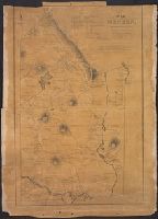
- Found in:
- Beinecke Rare Book and Manuscript Library > A Map of Mendon, Worcester County, Mass. By John Geo. Metcalf, M.D. Newell nelson, Surveyor.
- Published / Created:
- 1897
- Call Number:
- 764 M64 1897
- Container / Volume:
- BRBL_00458
- Image Count:
- 1
- Resource Type:
- Maps, Atlases & Globes
- Found in:
- Beinecke Rare Book and Manuscript Library > Breck's map of Milton : showing area taken for the Blue Hills Reservation of the Metropolitan Park System, also location of fire alarm boxes and police signal stations / Chas. C.E. Breck, Civil Engr.
- Published / Created:
- 1863
- Call Number:
- 774AM G33 1863
- Container / Volume:
- BRBL_00500
- Image Count:
- 1
- Resource Type:
- Maps, Atlases & Globes
- Found in:
- Beinecke Rare Book and Manuscript Library > Gettysburg Battlefield : Battle fought at Gettyburg Pa. on July 1st 2d 3d byt the Federal and Confederate armies.
- Creator:
- Searl, A. D
- Published / Created:
- [1854]
- Call Number:
- 825gmb L435 1854
- Container / Volume:
- BRBL_00576
- Image Count:
- 1
- Resource Type:
- Maps, Atlases & Globes
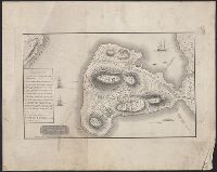
- Found in:
- Beinecke Rare Book and Manuscript Library > Lawrence City, Kanzas Territory / surveyed Oct. 1854 by A.D. Searl.
- Creator:
- Whitman, E. B. (Edmund Burke), 1812-1883
- Published / Created:
- 1856
- Call Number:
- 825 1856
- Container / Volume:
- BRBL_00573
- Image Count:
- 1
- Resource Type:
- Maps, Atlases & Globes
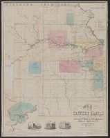
- Found in:
- Beinecke Rare Book and Manuscript Library > Map of Eastern Kansas / by E.B. Whitman & A.D. Searl.
- Published / Created:
- 1861
- Call Number:
- 754 1861
- Container / Volume:
- BRBL_00416
- Image Count:
- 1
- Resource Type:
- Maps, Atlases & Globes
- Found in:
- Beinecke Rare Book and Manuscript Library > Map showing the R.R. Routes, Coast Lines, and Forts, between Boston & Norfolk Harbor.
- Published / Created:
- 1838
- Call Number:
- 766 1838
- Container / Volume:
- BRBL_00466
- Image Count:
- 1
- Resource Type:
- Maps, Atlases & Globes
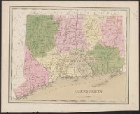
- Found in:
- Beinecke Rare Book and Manuscript Library > Connecticut.
- Published / Created:
- 1842
- Call Number:
- 766 1842A
- Container / Volume:
- BRBL_00466
- Image Count:
- 1
- Resource Type:
- Maps, Atlases & Globes
- Found in:
- Beinecke Rare Book and Manuscript Library > Connecticut.
- Published / Created:
- 1893
- Call Number:
- 766 F16 1893
- Container / Volume:
- BRBL_00468
- Image Count:
- 1
- Resource Type:
- Maps, Atlases & Globes
- Found in:
- Beinecke Rare Book and Manuscript Library > Fairfield [County].
- Published / Created:
- [1833?]
- Call Number:
- 764CA 1833
- Container / Volume:
- BRBL_00460
- Image Count:
- 1
- Resource Type:
- Maps, Atlases & Globes
- Found in:
- Beinecke Rare Book and Manuscript Library > Geological map of Massachusetts By Edw. D. Hitchcock 1833 ...
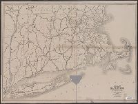
- Creator:
- Massachusetts. Board of Railroad Commissioners
- Published / Created:
- 1882
- Call Number:
- 764gme 1882
- Container / Volume:
- BRBL_00462
- Image Count:
- 1
- Resource Type:
- Maps, Atlases & Globes
- Found in:
- Beinecke Rare Book and Manuscript Library > Map of the railroads of the state of Massachusetts : accompanying the report of the Railroad Commissioners.
- Published / Created:
- 1884
- Call Number:
- 764gme 1884
- Container / Volume:
- BRBL_00462
- Image Count:
- 1
- Resource Type:
- Maps, Atlases & Globes
- Found in:
- Beinecke Rare Book and Manuscript Library > Map of the railroads of the state of Massachusetts : accompanying the report of the Railroad Commissioners.
- Published / Created:
- 1893
- Call Number:
- 766 1893W
- Container / Volume:
- BRBL_00467
- Image Count:
- 1
- Resource Type:
- Maps, Atlases & Globes
- Found in:
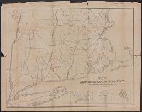
- Beinecke Rare Book and Manuscript Library > Latest map and index of Eastern Connecticut.
- Creator:
- O.H. Bailey & Co
- Published / Created:
- 1878
- Call Number:
- 766 B77 1878
- Container / Volume:
- BRBL_00468
- Image Count:
- 1
- Resource Type:
- Maps, Atlases & Globes
- Found in:
- Beinecke Rare Book and Manuscript Library > View of Bristol, Conn. / by O.H. Bailey & Co. Beck & Pauli lith.
- Creator:
- Massachusetts. Board of Railroad Commissioners
- Published / Created:
- 1874
- Call Number:
- 764gme 1874
- Container / Volume:
- BRBL_00462
- Image Count:
- 1
- Resource Type:
- Maps, Atlases & Globes
- Found in:
- Beinecke Rare Book and Manuscript Library > Map of the railroads of the state of Massachusetts : accompanying the report of the railroad commissioners. 1874.
- Published / Created:
- 1791
- Call Number:
- 7645cea 1791
- Container / Volume:
- BRBL_00463
- Image Count:
- 1
- Resource Type:
- Maps, Atlases & Globes
- Found in:
- Beinecke Rare Book and Manuscript Library > A chart of Nantucket Shoals by Capt. Paul Pinkham.
- Creator:
- Eldridge, George, 1821-1879
- Published / Created:
- 1891
- Call Number:
- 764cea B65 1891E
- Container / Volume:
- BRBL_00461
- Image Count:
- 1
- Resource Type:
- Maps, Atlases & Globes
- Found in:
- Beinecke Rare Book and Manuscript Library > Eldridge's new chart of Boston Harbor : compiled from the latest surveys / engraved by G.W. Boynton.
- Published / Created:
- 1876
- Call Number:
- 7645cea 1876
- Container / Volume:
- BRBL_00463
- Image Count:
- 1
- Resource Type:
- Maps, Atlases & Globes
- Found in:
- Beinecke Rare Book and Manuscript Library > Map of Martha's Vineyard : Elizabeth Islands and vicinity / from the latest maps of the U.S. Coast Survey.
- Published / Created:
- [1840.]
- Call Number:
- 765CA 1840
- Container / Volume:
- BRBL_00464
- Image Count:
- 1
- Resource Type:
- Maps, Atlases & Globes
- Found in:
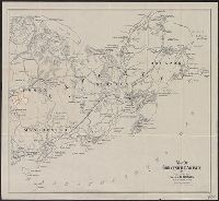
- Beinecke Rare Book and Manuscript Library > A geological map of Rhode-Island. By Charles T. Jackson. 1840.
- Published / Created:
- 1879
- Call Number:
- 766am N46 1879V
- Container / Volume:
- BRBL_00474
- Image Count:
- 1
- Resource Type:
- Maps, Atlases & Globes
- Found in:
- Beinecke Rare Book and Manuscript Library > The city of New Haven, Conn.
- Creator:
- O.H. Bailey & Co
- Published / Created:
- 1877
- Call Number:
- 766am H26 1877
- Container / Volume:
- BRBL_00474
- Image Count:
- 1
- Resource Type:
- Maps, Atlases & Globes
- Found in:
- Beinecke Rare Book and Manuscript Library > The city of Hartford, Connecticut. By O.H. Bailey & Co.
- Published / Created:
- c1902.
- Call Number:
- 762am M86 1902
- Container / Volume:
- BRBL_00451
- Image Count:
- 1
- Resource Type:
- Maps, Atlases & Globes
- Found in:
- Beinecke Rare Book and Manuscript Library > Birds-eye view from summit of Mt. Washington, White Mountains, New Hampshire.
- Published / Created:
- 1914
- Call Number:
- 764 P44 1914
- Container / Volume:
- BRBL_00459
- Image Count:
- 1
- Resource Type:
- Maps, Atlases & Globes
- Found in:
- Beinecke Rare Book and Manuscript Library > Map of Petersham, Mass. ; showing town roads, wood roads, and trails, for a portion of the Township / prepared and published by The Village Improvement Society from Existing Surveys and Original Transverses.
- Creator:
- Walker Lith. & Pub. Co
- Published / Created:
- 1909
- Call Number:
- 764 B65 1909
- Container / Volume:
- BRBL_00456
- Image Count:
- 1
- Resource Type:
- Maps, Atlases & Globes
- Found in:
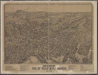
- Beinecke Rare Book and Manuscript Library > Map of Boston proper.
- Creator:
- Shurtleff, Arthur A. (Arthur Asahel), 1870-1957
- Published / Created:
- 1909
- Call Number:
- 764 B65 1909B
- Container / Volume:
- BRBL_00456
- Image Count:
- 1
- Resource Type:
- Maps, Atlases & Globes
- Found in:
- Beinecke Rare Book and Manuscript Library > Map of the existing and proposed circumferential thoroughfares of the district / Arthur A. Shurtleff.
- Creator:
- Geo. H. Walker & Co
- Published / Created:
- c1904.
- Call Number:
- 764gmb T193 1904
- Container / Volume:
- BRBL_00462
- Image Count:
- 1
- Resource Type:
- Maps, Atlases & Globes
- Found in:
- Beinecke Rare Book and Manuscript Library > City of Taunton.
- Published / Created:
- 1918
- Call Number:
- 764gme B65 1918
- Container / Volume:
- BRBL_00462
- Image Count:
- 1
- Resource Type:
- Maps, Atlases & Globes
- Found in:
- Beinecke Rare Book and Manuscript Library > Boston Subway, East Boston Tunnel, Washington St. Tunnel, tunnel for Cambridge connection, Dorchester Tunnel, Boylston St. Subway & East Boston Tunnel Connection.
- Creator:
- Geo. H. Walker & Co
- Published / Created:
- 1897
- Call Number:
- 7715gmb 1897
- Image Count:
- 1
- Resource Type:
- Maps, Atlases & Globes
- Found in:
- Beinecke Rare Book and Manuscript Library > Map of Long Island / Geo H. Walker & Co.
- Published / Created:
- 1893
- Call Number:
- 766 H26 1893
- Container / Volume:
- BRBL_00468
- Image Count:
- 1
- Resource Type:
- Maps, Atlases & Globes
- Found in:
- Beinecke Rare Book and Manuscript Library > Hartford [County].
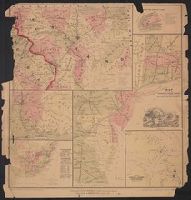
- Creator:
- Ensign, Thayer & Co
- Published / Created:
- [1850]
- Call Number:
- 75 1850T
- Container / Volume:
- BRBL_00400
- Image Count:
- 1
- Resource Type:
- Maps, Atlases & Globes
- Found in:
- Beinecke Rare Book and Manuscript Library > Map of the United States and Mexico.
- Creator:
- Rand Avery Supply Company
- Published / Created:
- [1890?].
- Call Number:
- 753gme 1890
- Container / Volume:
- BRBL_00415
- Image Count:
- 1
- Resource Type:
- Maps, Atlases & Globes
- Found in:
- Beinecke Rare Book and Manuscript Library > Tourist map of the Boston and Maine Railroad.
- Published / Created:
- 1833
- Call Number:
- 761 AU45 1833
- Container / Volume:
- BRBL_00448
- Image Count:
- 1
- Resource Type:
- Maps, Atlases & Globes
- Found in:
- Beinecke Rare Book and Manuscript Library > Plan of the village of Augusta, Maine, shewing the Kennebeck Dam - from actual surveys by B.F. Perham, C.E.,
- Published / Created:
- [1866?].
- Call Number:
- 761 P837 1866
- Container / Volume:
- BRBL_00449
- Image Count:
- 1
- Resource Type:
- Maps, Atlases & Globes
- Found in:
- Beinecke Rare Book and Manuscript Library > Map of the City of Portland : showing that portion of it destroyed by fire July 4, 1866.
- Published / Created:
- 1849
- Call Number:
- 76gme 1849P
- Container / Volume:
- BRBL_00446A
- Image Count:
- 1
- Resource Type:
- Maps, Atlases & Globes
- Found in:
- Beinecke Rare Book and Manuscript Library > Map of the Boston and Maine Railroad showing its relative position & connection with other Railroads. Prepared by order of the Committee of Investigation. Wm. Parrott, Engineer.
- Creator:
- Swett and Powers (Firm)
- Published / Created:
- [ca. 1851?]
- Call Number:
- 76gme 1850
- Container / Volume:
- BRBL_00446A
- Image Count:
- 1
- Resource Type:
- Maps, Atlases & Globes
- Found in:
- Beinecke Rare Book and Manuscript Library > Map of the New York & Boston Railway : with its connections with other railways.
- Creator:
- Coolidge, A. J. (Austin Jacobs)
- Published / Created:
- 1859
- Call Number:
- 761 1859
- Container / Volume:
- BRBL_00447
- Image Count:
- 1
- Resource Type:
- Maps, Atlases & Globes
- Found in:
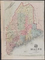
- Beinecke Rare Book and Manuscript Library > Maine 1859.
- Published / Created:
- 1871
- Call Number:
- 761 B98 1870
- Container / Volume:
- BRBL_00448
- Image Count:
- 1
- Resource Type:
- Maps, Atlases & Globes
- Found in:
- Beinecke Rare Book and Manuscript Library > Map of Buxton, Maine / by Daniel Dennet, 1870.