Search
You Searched For
Search Results
- Creator:
- Chabert, Joseph Bernard, marquis de, 1724-1805
- Published / Created:
- 25th, March 1775.
- Call Number:
- 72cea 1775
- Container / Volume:
- BRBL_00688
- Image Count:
- 1
- Resource Type:
- Maps, Atlases & Globes
- Found in:
- Beinecke Rare Book and Manuscript Library > A chart of the Banks of Newfoundland / drawn from a great number of hydrographical surveys, chiefly from those of Chabert, Cook, and Fleurieu, connected and ascertained by astronomical observations.
- Creator:
- Chabert, Joseph Bernard, marquis de, 1724-1805
- Published / Created:
- 25th, March 1775.
- Call Number:
- 72cea 1775
- Container / Volume:
- BRBL_00373
- Image Count:
- 1
- Resource Type:
- Maps, Atlases & Globes
- Found in:
- Beinecke Rare Book and Manuscript Library > A chart of the Banks of Newfoundland / drawn from a great number of hydrographical surveys, chiefly from those of Chabert, Cook, and Fleurieu, connected and ascertained by astronomical observations.
- Creator:
- Delarochette, L. (Louis), 1731-1802
Dicquemare, (Jacques-Francois), M. l'abbe, 1733-1789, creator
Faden, William, 1749-1836
- Published / Created:
- 1780 June 17
- Call Number:
- 1982 Folio 10
- Image Count:
- 1
- Found in:
- Beinecke Rare Book and Manuscript Library > A chart of the British Channel and the Bay of Biscay with a part of the North Sea, and the entrance of St. George's Channel
- Published / Created:
- 1841
- Call Number:
- 213cea 1819
- Image Count:
- 1
- Resource Type:
- Maps, Atlases & Globes
- Found in:
- Beinecke Rare Book and Manuscript Library > A chart of the Cape Verd[e] Islands by Lieuts. Vidal & Mudge, of H.M. Ship Leven ... in 1819,20 & 21. Engraved & Printed by W. Hooker.
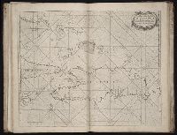
- Call Number:
- 1978 Folio 10
- Collection Title:
- The English pilot: describing the West-India navigation, from Hudson's-Bay to the river Amazones
- Image Count:
- 2
- Found in:
- Beinecke Rare Book and Manuscript Library > A chart of the Caribe Islands
- Call Number:
- 1973 Folio 76
- Collection Title:
- The English pilot: describing the sea-coasts, capes, head-lands, rivers, bays, roads, havens
- Image Count:
- 1
- Found in:
- Beinecke Rare Book and Manuscript Library > A chart of the Caribe ilands
- Creator:
- Lucas, Fielding, 1781-1854
- Published / Created:
- c1852.
- Call Number:
- 778cea 1852
- Container / Volume:
- BRBL_00504A
- Image Count:
- 1
- Resource Type:
- Maps, Atlases & Globes
- Found in:
- Beinecke Rare Book and Manuscript Library > A chart of the Chesapeake and Delaware Bays / compiled and published by Fielding Lucas Junr.
- Creator:
- Lucas, Fielding, 1781-1854
Warr, John, b. ca. 1798
Warr, William W
- Published / Created:
- [1862], c1852
- Call Number:
- 21cea 1862
- Image Count:
- 1
- Resource Type:
- Maps, Atlases & Globes
- Found in:
- Beinecke Rare Book and Manuscript Library > A chart of the Chesapeake and Delaware Bays / compiled and published by Fielding Lucas.
- Creator:
- Jefferys, Thomas, -1771
- Published / Created:
- 25th March, 1775.
- Call Number:
- 7345cea 1775A
- Container / Volume:
- BRBL_00689
- Image Count:
- 1
- Resource Type:
- Maps, Atlases & Globes
- Found in:
- Beinecke Rare Book and Manuscript Library > A chart of the Gulf of St. Laurence [cartographic material] : composed from a great number of actual surveys and other materials, regulated and connected by astronomical observations.
- Published / Created:
- [1776?]
- Call Number:
- 764cea B65 1776
- Container / Volume:
- BRBL_00461
- Image Count:
- 1
- Resource Type:
- Maps, Atlases & Globes
- Found in:
- Beinecke Rare Book and Manuscript Library > A chart of the Harbour of Boston ...
- Published / Created:
- [1749?]
- Call Number:
- 853 1749
- Container / Volume:
- BRBL_00640
- Image Count:
- 1
- Resource Type:
- Maps, Atlases & Globes
- Found in:
- Beinecke Rare Book and Manuscript Library > A chart of the Island of Hispaniola with the Windward passage from Iamaica betweene the East end of Cuba & the West end of Hispaniola. Sold by George Grierson, Dublin.
- Call Number:
- 1976 1233
- Collection Title:
- Forty-two new maps of Asia, Africa, and America ... : all engrav’d, according to the latest
- Image Count:
- 1
- Found in:
- Beinecke Rare Book and Manuscript Library > A chart of the South Sea coast from the Steights [sic] of Magellan to Arica
- Published / Created:
- [1748?]
- Call Number:
- 935cea 1748
- Container / Volume:
- BRBL_00674
- Image Count:
- 1
- Resource Type:
- Maps, Atlases & Globes
- Found in:
- Beinecke Rare Book and Manuscript Library > A chart of the Southern Part of South America With the Track of the Centurion from the Island of St. Catherines to the Island of Juan Fernandes In which is inserted the Variation and Soundings observ'd on board her, Together with her Deviation from her es
- Creator:
- Cook, James, 1728-1779, creator
Larken, sculpt
- Published / Created:
- 1766
- Call Number:
- 2003 Folio 85
- Image Count:
- 1
- Found in:
- Beinecke Rare Book and Manuscript Library > A chart of the Straights of Bellisle: with part of the coast of Newfoundland and Labradore from actual surveys. Taken by order of Commodore Pallisser, Governor of Newfoundland, Labrador, &ca
- Published / Created:
- 1775
- Call Number:
- 966 1775
- Container / Volume:
- BRBL_00676
- Image Count:
- 1
- Resource Type:
- Maps, Atlases & Globes
- Found in:
- Beinecke Rare Book and Manuscript Library > A chart of the Straits of Magellan. Inlarged from a chart published at Madrid in 1769, by Don Juan de la Cruz Cano y Olmedilla ... and improved from the observations and surveys of Captns. Byron, Wallis and Carteret ...
- Call Number:
- 1976 1233
- Collection Title:
- Forty-two new maps of Asia, Africa, and America ... : all engrav’d, according to the latest
- Image Count:
- 1
- Found in:
- Beinecke Rare Book and Manuscript Library > A chart of the Streights of Magellan
- Published / Created:
- 1795
- Call Number:
- 85 1795
- Container / Volume:
- BRBL_00637
- Image Count:
- 1
- Resource Type:
- Maps, Atlases & Globes
- Found in:
- Beinecke Rare Book and Manuscript Library > A chart of the West Indies, from the latest marine Journals and Surveys.
- Creator:
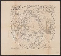
- Berghaus, Heinrich Karl Wilhelm, 1797-1884
Boell, William
Bowen & Co
Kane, Elisha Kent, 1820-1857
Petermann, A. (August), 1822-1878
- Published / Created:
- [1860]
- Call Number:
- 18 1860A
- Container / Volume:
- BRBL_00013
- Image Count:
- 1
- Resource Type:
- Maps, Atlases & Globes
- Found in:
- Beinecke Rare Book and Manuscript Library > A chart of the arctic regions : projected from Berghaus & Petermann, the charts of E.K. Kane, materials in the British Hydrographic office, etc. / eng. by W. Boell.
- Creator:
- Waddington, Robert
- Call Number:
- 1973 Folio 116
- Collection Title:
- The English pilot: describing the West-India navigation, from Hudson's-Bay to the river Amazones
- Image Count:
- 1
- Found in:
- Beinecke Rare Book and Manuscript Library > A chart of the coast of Guayana, from the entrance of the River Orinoco ...
- Call Number:
- 1976 1233
- Collection Title:
- Forty-two new maps of Asia, Africa, and America ... : all engrav’d, according to the latest
- Image Count:
- 1
- Found in:
- Beinecke Rare Book and Manuscript Library > A chart of the coasts of Peru, Quito, Popayan and the isthmus of Darien
- Creator:
- Delarochette, L. (Louis), 1731-1802, creator
- Published / Created:
- 1780 June 28
- Call Number:
- 1982 Folio 10
- Image Count:
- 1
- Found in:
- Beinecke Rare Book and Manuscript Library > A chart of the coasts of Spain and Portugal, with the Balearic Islands, and part of the coast of Barbary
- Creator:
- Delarochette, L. (Louis), 1731-1802
- Published / Created:
- June 28th, 1780.
- Call Number:
- 39cea 1780
- Container / Volume:
- BRBL_00192
- Image Count:
- 1
- Resource Type:
- Maps, Atlases & Globes
- Found in:
- Beinecke Rare Book and Manuscript Library > A chart of the coasts of Spain and Portugal, with the Balearic Islands, and part of the coast of Barbary / by L.S. De la Rochette.
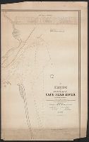
- Published / Created:
- 1839
- Call Number:
- 785cea C17 1839
- Container / Volume:
- BRBL_00514
- Image Count:
- 4
- Resource Type:
- Maps, Atlases & Globes
- Found in:
- Beinecke Rare Book and Manuscript Library > A chart of the entrance of Cape Fear River ... / J.K. Paulding ... lith. of P. Haas.
- Creator:
- Morris, Charles, fl. 1749, cartographer
- Published / Created:
- 1759?]
- Call Number:
- 732cea H13 1759
- Container / Volume:
- BRBL_00378
- Image Count:
- 1
- Resource Type:
- Maps, Atlases & Globes
- Found in:
- Beinecke Rare Book and Manuscript Library > A chart of the harbour of Halifax, in Nova Scotia : with Jebucto Bay and Cape Sambrô, also the islands, ledges of rocks, shoals & soundings / survey'd, by order of His Excellency Brigadier General Lawrence, Governour of the Province of Nova Scotia, by Ch
- Call Number:
- 1973 Folio 76
- Collection Title:
- The English pilot: describing the sea-coasts, capes, head-lands, rivers, bays, roads, havens
- Image Count:
- 1
- Found in:
- Beinecke Rare Book and Manuscript Library > A chart of the iland of Hispaniola
- Call Number:
- 1978 Folio 10
- Collection Title:
- The English pilot: describing the West-India navigation, from Hudson's-Bay to the river Amazones
- Image Count:
- 1
- Found in:
- Beinecke Rare Book and Manuscript Library > A chart of the island of Hispaniola
- Creator:
- Lodge, John, -1796
- Published / Created:
- 31 Augst. 1780.
- Call Number:
- 8555 1780A
- Container / Volume:
- BRBL_00695
- Image Count:
- 1
- Resource Type:
- Maps, Atlases & Globes
- Found in:
- Beinecke Rare Book and Manuscript Library > A chart of the island of Jamaica [cartographic material] : with its bays, harbours, rocks, soundings, &c. / Jno. Lodge, sculp.
- Creator:
- Delarochette, L. (Louis), 1731-1802, creator
- Published / Created:
- 1781 January 1
- Call Number:
- 1982 Folio 10
- Image Count:
- 1
- Found in:
- Beinecke Rare Book and Manuscript Library > A chart of the islands of Jersey and Guernsey, Sark, Herm and Alderney, with the adjacent coast of France
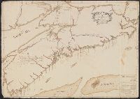
- Published / Created:
- [ca. 1758]
- Call Number:
- 732cea 1758
- Container / Volume:
- BRBL_00709
- Image Count:
- 1
- Resource Type:
- Maps, Atlases & Globes
- Found in:
- Beinecke Rare Book and Manuscript Library > A chart of the peninsula of Nova Scotia by Charles Morris.
- Call Number:
- 1978 Folio 10
- Collection Title:
- The English pilot: describing the West-India navigation, from Hudson's-Bay to the river Amazones
- Image Count:
- 1
- Found in:
- Beinecke Rare Book and Manuscript Library > A chart of the sea coast of New Found Land, New Scotland, New England, New York, New Jersey, with Virginia and Maryland
- Creator:
- W. Mount and T. Page
- Published / Created:
- [between 1732 and 1749]
- Call Number:
- 71cea 1723
- Container / Volume:
- BRBL_00688
- Image Count:
- 1
- Resource Type:
- Maps, Atlases & Globes
- Found in:
- Beinecke Rare Book and Manuscript Library > A chart of the sea coast of New Found Land, New Scotland, New England, New York, New Jersey, with Virginia and Maryland.
- Call Number:
- 1974 Folio 72
- Collection Title:
- The English pilot: describing the West-India navigation, from Hudson's-Bay to the river Amazones
- Image Count:
- 1
- Found in:
- Beinecke Rare Book and Manuscript Library > A chart of the sea coast of Newfoundland, New Scotland, New England, New York, New Jersey, with Virginia and Maryland
- Call Number:
- 1973 Folio 116
- Collection Title:
- The English pilot: describing the West-India navigation, from Hudson's-Bay to the river Amazones
- Image Count:
- 1
- Found in:
- Beinecke Rare Book and Manuscript Library > A chart of the sea coast of Newfoundland, New Scotland, New England, New York, New Jersey, with Virginia and Maryland
- Call Number:
- 1973 Folio 114
- Collection Title:
- The English pilot: describing the West-India navigation, from Hudson's-Bay to the river Amazones
- Image Count:
- 1
- Resource Type:
- Maps, Atlases & Globes
- Found in:
- Beinecke Rare Book and Manuscript Library > A chart of the sea coast of Newfoundland, New Scotland, New England, New York, New Jersey, with Virginia and Maryland
- Creator:
- Seller, John, fl. 1658-1698
- Published / Created:
- 1675?]
- Call Number:
- 755cea 1675
- Container / Volume:
- BRBL_00441
- Image Count:
- 1
- Resource Type:
- Maps, Atlases & Globes
- Found in:
- Beinecke Rare Book and Manuscript Library > A chart of the sea coasts of New-England, New-Jarsey, Virginia, Maryland and Carolina : from C. Cod to C. Hatteras / by John Seller, hydrogr. to the King ; Iames Clerk sculpsit.
- Creator:
- Cook, James, 1728-1779
Gulielmus Whitchurch
- Published / Created:
- 1776
- Call Number:
- 1977 +300
- Collection Title:
- A voyage towards the South pole, and round the world. Performed in His Majesty’s ships the
- Image Count:
- 1
- Resource Type:
- Maps, Atlases & Globes
- Found in:
- Beinecke Rare Book and Manuscript Library > A chart of the southern hemisphere; shewing the tracks of some of the most distinguished navigators
- Creator:
- Moll, Herman, d. 1732
- Call Number:
- 85 1745A
- Container / Volume:
- BRBL_00636
- Image Count:
- 1
- Resource Type:
- Maps, Atlases & Globes
- Found in:
- Beinecke Rare Book and Manuscript Library > A chart of ye West-Indies or the islands of America in the North Sea &c., being ye present seat of war / by Herman Moll, geographer.
- Creator:
- Thornton, John, 1641-1708
- Call Number:
- 1973 Folio 76
- Collection Title:
- The English pilot: describing the sea-coasts, capes, head-lands, rivers, bays, roads, havens
- Image Count:
- 1
- Found in:
- Beinecke Rare Book and Manuscript Library > A chart of ye iland of New Found Land
- Creator:
- Seller, John, fl. 1658-1698
- Published / Created:
- [1671?]
- Call Number:
- 319cea 1671
- Container / Volume:
- BRBL_00042
- Image Count:
- 1
- Resource Type:
- Maps, Atlases & Globes
- Found in:
- Beinecke Rare Book and Manuscript Library > A chart of ye narrow seas / newly corrected by John Seller, hydrographer to the kings most excellent majestie.
- Creator:
- Thornton, John, 1641-1708
- Call Number:
- 1973 Folio 76
- Collection Title:
- The English pilot: describing the sea-coasts, capes, head-lands, rivers, bays, roads, havens
- Image Count:
- 1
- Found in:
- Beinecke Rare Book and Manuscript Library > A chart of ye north part of America
- Creator:
- Vancouver, George, 1757-1798
- Published / Created:
- 1798
- Call Number:
- 845 1798A
- Container / Volume:
- BRBL_00619
- Image Count:
- 1
- Resource Type:
- Maps, Atlases & Globes
- Found in:
- Beinecke Rare Book and Manuscript Library > A chart shewing part of the coast of N.W. America : with the tracks of His Majesty's sloop Discovery and armed tender Chatham / commanded by George Vancouver, esqr. and prepared under his immediate inspection by Lieut. Joseph Baker, in which the continent
- Creator:
- Vancouver, George, 1757-1798
- Published / Created:
- 1798
- Call Number:
- 845 1798C
- Container / Volume:
- BRBL_00619
- Image Count:
- 1
- Resource Type:
- Maps, Atlases & Globes
- Found in:
- Beinecke Rare Book and Manuscript Library > A chart shewing part of the coast of N.W. America, with the tracks of His Majesty's sloop Discovery and armed tender Chatham / commanded by George Vancouver, esq. and prepared under his immediate inspection by Lieut. Joseph Baker, in which the continental
- Creator:
- Vancouver, George, 1757-1798
- Published / Created:
- 1798
- Call Number:
- 845 1798H
- Container / Volume:
- BRBL_00619
- Image Count:
- 1
- Resource Type:
- Maps, Atlases & Globes
- Found in:
- Beinecke Rare Book and Manuscript Library > A chart shewing part of the coast of N.W. America, with the tracks of His Majesty's sloop Discovery and armed tender Chatham / commanded by George Vancouver, esq. and prepared under his immediate inspection by Lieut. Joseph Baker, in which the continental
- Creator:
- Vancouver, George, 1757-1798
- Published / Created:
- 1798
- Call Number:
- 845 1798B
- Container / Volume:
- BRBL_00619
- Image Count:
- 1
- Resource Type:
- Maps, Atlases & Globes
- Found in:
- Beinecke Rare Book and Manuscript Library > A chart shewing part of the coast of N.W. America, with the tracks of His Majesty's sloop Discovery and armed tender Chatham / commanded by George Vancouver, esqr. and prepared from the foregoing surveys under his immediate inspection by Lieut. Edwd. Robe
- Creator:
- Vancouver, George, 1757-1798
- Published / Created:
- 1798
- Call Number:
- 845 1798G
- Container / Volume:
- BRBL_00619
- Image Count:
- 1
- Resource Type:
- Maps, Atlases & Globes
- Found in:
- Beinecke Rare Book and Manuscript Library > A chart shewing part of the coast of N.W. America, with the tracks of His Majesty's sloop Discovery and armed tender Chatham / commanded by George Vancouver, esqr. and prepared under his immediate inspection by Lieut. Joseph Baker, in which the continenta
- Creator:
- Vancouver, George, 1757-1798
- Published / Created:
- 1798
- Call Number:
- 845 1798F
- Container / Volume:
- BRBL_00619
- Image Count:
- 1
- Resource Type:
- Maps, Atlases & Globes
- Found in:
- Beinecke Rare Book and Manuscript Library > A chart shewing part of the coast of N.W. America, with the tracks of His Majesty's sloop Discovery and armed tender Chatham / commanded by George Vancouver, esqr. and prepared under his immediate inspection by Lieut. Joseph Baker, in which the continenta
- Creator:
- Vancouver, George, 1757-1798
- Published / Created:
- 1798
- Call Number:
- 845 1798D
- Container / Volume:
- BRBL_00619
- Image Count:
- 1
- Resource Type:
- Maps, Atlases & Globes
- Found in:
- Beinecke Rare Book and Manuscript Library > A chart shewing part of the coast of N.W. America, with the tracks of His Majesty's sloop Discovery and armed tender Chatham / commanded by George Vancouver, esqr. and prepared under his immediate inspection by Lieut. Joseph Baker, in which the continenta
- Creator:
- Vancouver, George, 1757-1798
- Published / Created:
- 1798
- Call Number:
- 845 1798E
- Container / Volume:
- BRBL_00619
- Image Count:
- 1
- Resource Type:
- Maps, Atlases & Globes
- Found in:
- Beinecke Rare Book and Manuscript Library > A chart shewing part of the coast of N.W. America, with the tracks of His Majesty's sloop Discovery and armed tender Chatham / commanded by George Vancouver, esqu. and prepared under his immediate inspection by Lieut. Joseph Baker, in which the continenta
- Creator:
- Gaudy, Iohn
- Call Number:
- 1974 Folio 72
- Collection Title:
- The English pilot: describing the West-India navigation, from Hudson's-Bay to the river Amazones
- Image Count:
- 1
- Found in:
- Beinecke Rare Book and Manuscript Library > A chart shewing part of the sea coast of New Foundland from ye Bay of Bulls to little Plecentia ...
- Published / Created:
- 1715
- Call Number:
- 1978 Folio 10
- Collection Title:
- The English pilot: describing the West-India navigation, from Hudson's-Bay to the river Amazones
- Image Count:
- 1
- Found in:
- Beinecke Rare Book and Manuscript Library > A chart shewing part of the sea coast of New Foundland from ye Bay of Bulls to little Plecentia ...