Search
You Searched For
Search Results
- Creator:
- Jefferys, Thomas, d. 1771
- Published / Created:
- 1794
- Call Number:
- 795cea 1794
- Container / Volume:
- BRBL_00523
- Image Count:
- 1
- Resource Type:
- Maps, Atlases & Globes
- Found in:
- Beinecke Rare Book and Manuscript Library > The western coast of Louisiana and the coast of New Leon / by Thos. Jefferys, geographer to His Majesty.
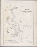
- Creator:
- Blake, Jacob Edmund, 1811 or 12-1846
- Published / Created:
- 1842?]
- Call Number:
- 796fab Sa13 1842E
- Container / Volume:
- BRBL_00530
- Image Count:
- 1
- Resource Type:
- Maps, Atlases & Globes
- Found in:
- Beinecke Rare Book and Manuscript Library > Part of the boundary between the United States and Texas, north of Sabine River from the 39th [i.e. 36th] to the 72nd mile mound / drawn from the notes of survey and copied for the use of the commissioners under the Convention of 25th April 1838 by J. Edm
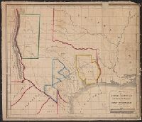
- Creator:
- Croskey, Joseph Rodney
- Published / Created:
- 1842
- Call Number:
- 796ad 1842
- Container / Volume:
- BRBL_00529
- Image Count:
- 1
- Resource Type:
- Maps, Atlases & Globes
- Found in:
- Beinecke Rare Book and Manuscript Library > Map of the Republic of Texas, exhibiting the property of John Woodward / drawn by Joseph Rodney Croskey.
- Creator:
- Lee, Thomas Jefferson, 1808-1891
- Published / Created:
- 1842?]
- Call Number:
- 796fab Sa13 1842J
- Container / Volume:
- BRBL_00530
- Image Count:
- 1
- Resource Type:
- Maps, Atlases & Globes
- Found in:
- Beinecke Rare Book and Manuscript Library > Sabine Pass and mouth of the river Sabine in the sea / surveyed under the direction of Major J.D. Graham, U.S. Top.l Engineers ; by Lieut. T.J. Lee, U.S. Top.l Engineers and Cap.t P.J. Pillans, Texan Army, attached to the Joint Commission for marking the
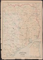
- Creator:
- Asher & Adams
- Published / Created:
- [1878?]
- Call Number:
- 796fb 1878
- Container / Volume:
- BRBL_00530
- Image Count:
- 1
- Resource Type:
- Maps, Atlases & Globes
- Found in:
- Beinecke Rare Book and Manuscript Library > Asher & Adams' Texas : western portion.
- Published / Created:
- 1841 [i.e. 1842]
- Call Number:
- 796fab 1842
- Container / Volume:
- BRBL_00530
- Image Count:
- 1
- Resource Type:
- Maps, Atlases & Globes
- Found in:
- Beinecke Rare Book and Manuscript Library > A new map of Texas / Day & Haghe, lith.rs to the Queen.
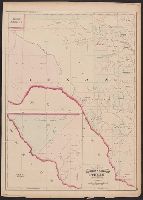
- Creator:
- Blake, Jacob Edmund, 1811 or 12-1846
- Published / Created:
- 1842?]
- Call Number:
- 796fab Sa13 1842D
- Container / Volume:
- BRBL_00530
- Image Count:
- 1
- Resource Type:
- Maps, Atlases & Globes
- Found in:
- Beinecke Rare Book and Manuscript Library > Part of the boundary between the United States and Texas, from Sabine River northward to the 36th mile mound / drawn from the notes of survey and copied for the use of the commissioners under the Convention of 25th April 1838, by J. Edm.d Blake 1st Lieut.
- Published / Created:
- 1860?]
- Call Number:
- 796gme 1860
- Container / Volume:
- BRBL_00531
- Image Count:
- 1
- Resource Type:
- Maps, Atlases & Globes
- Found in:
- Beinecke Rare Book and Manuscript Library > A geographically correct map of the Red River, Sabine & Western Railway (under construction) and connections : showing distribution of pine forests (compiled from maps of U.S. government), also location of coal, iron, and oil deposits.
- Creator:
- Asher & Adams
- Published / Created:
- [1878?]
- Call Number:
- 796fb 1878A
- Container / Volume:
- BRBL_00530
- Image Count:
- 1
- Resource Type:
- Maps, Atlases & Globes
- Found in:
- Beinecke Rare Book and Manuscript Library > Asher & Adams' Texas : eastern portion.
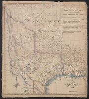
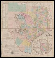
- Creator:
- Creuzbaur, Robert
- Published / Created:
- 1850
- Call Number:
- 796 1850
- Container / Volume:
- BRBL_00525
- Image Count:
- 1
- Resource Type:
- Maps, Atlases & Globes
- Found in:
- Beinecke Rare Book and Manuscript Library > J. De Cordova's map of the state of Texas / compiled from the records of the general land office of the state by Robert Creuzbaur ; engraved by J.M. Atwood.