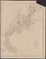
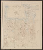
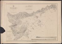
[Maury map collection ; ser. A2], Maury's wind & current chart, S. Atlantic, Maury's wind & current chart, South Atlantic, Maury's wind and current chart, series A, South Atlantic, Maury's wind and current chart, South Atlantic, and South Atlantic
Description:
"Series A.", Copy imperfect: All sheets torn and repaired along, Does not cover the southeastern Atlantic south of latitude 40° S., Includes notes., Shows prevailing wind direction by month., and Various eds. of some sheets with updated and additional information.
Publisher:
United States Hydrographical Office,
Subject (Geographic):
South Atlantic Ocean--Charts, diagrams, etc
Subject (Name):
Flye, Wm, Maury, Matthew Fontaine, 1806-1873. Wind and current charts, Sherman & Smith, Temple, William G. (William Grenville), 1824-1894, United States Naval Observatory, United States. Bureau of Ordnance and Hydrography, and United States. Hydrographic Office
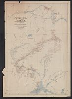
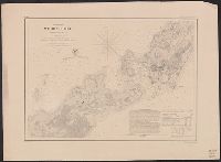
[Maury map collection ; Series A5], South Pacific, Wind and current chart of the South Pacific, and Wind and current chart, South Pacific
Description:
"[Engraved by] Oliver J. Stuart. N.Y."--Sheet 8, lower right margin., "Eng. by Sherman & Smith N.Y."--Sheet 10, lower right margin., Shows prevailing wind direction by month., and Similar wind and current charts of other oceans compiled from materials in the Bur
Publisher:
United States Hydrographical Office,
Subject (Geographic):
South Pacific Ocean--Charts, diagrams, etc
Subject (Name):
Gibbon, Lardner, Maury, Matthew Fontaine, 1806-1873. Wind and current charts, Sherman & Smith, Stuart, Oliver J, United States Naval Observatory, United States. Bureau of Ordnance and Hydrography, United States. Hydrographic Office, and Wells, C. H
[Maury map collection ; Series A3], Indian Ocean, and Wind and current chart, Indian Ocean
Description:
"Drawn by R.H. Wyman & G. B. Balsh, lieutenants, U.S. , April 1854"--Sheet 5, lower margin., "Series A.", and Copy imperfect: All sheets fold lined, with some tears along fold-line. Sheets 5-11discoloration throughout. Sheet 5 torn and repaired in lower right c
Publisher:
United States Hydrographical Office,
Subject (Geographic):
Indian Ocean--Maps
Subject (Name):
Balsh, G. B, Johnson, A. W, Maury, Matthew Fontaine, 1806-1873. Wind and current charts, United States. Hydrographic Office, Wells, C. H, Welsh, George P., -1860, and Wyman, R. H. (Robert Harris), 1822-1882
Detached from a report or document in the Congressional series, no. 3., Includes 7-line note on lead, coal and iron resources., and Shows lead and copper regions and 6 and 15 mile limits of land grant railroads.
Publisher:
General Land Office,
Subject (Geographic):
Illinois--Maps
Subject (Name):
Bowen & Co
Subject (Topic):
Natural resources--Illinois and Railroad land grants--Illinois--Maps
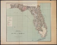
In upper left margin: Eleventh Census of the United States., Includes text and table of railroads' statutory authorizations., Prime meridians: Washington and Greenwich., and Relief indicated by hachures.
At head of title: United States Department of the Interior, Harold L. Ickes, Secretary, General Land Office, Fred W. Johnson, Commissioner. and Relief shown by hachures and spot heights.
House executive document (United States. Congress. House) ; 38th Congress, 1st session, no. 1.
Description:
"House R. Ex. Doc. No. 1, 38th Cong., 1st Sess.", Includes "List of private grants finally surveyed.", Relief shown by hachures., and Shows drainage, townships, railroads, mines, oil springs, land grants, etc.
Publisher:
Department of the Interior, General Land Office,
Subject (Geographic):
California--Maps and California--Surveys--Maps
Subject (Name):
Bien, Julius, 1826-1909
Subject (Topic):
Land grants--California--Maps and Mines and mineral resources--California--Maps
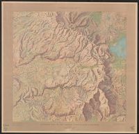
Yosemite Valley, Yosemite National Park, California
Description:
"Surveyed in 1905-1906 in cooperation with the State of California.", At head of title: Department of the Interior., Contour interval 50 feet. Datum is mean sea level., Includes location map and table of "Elevations of principal points.", and Relief shown by contours and spot heights.
Publisher:
U.S. Geological Survey,
Subject (Geographic):
Yosemite Valley (Calif.)--Maps
Subject (Name):
Douglas, Edward Morehouse, 1855-1932, Marshall, R. B. (Robert Bradford), 1867-1949, Matthes, François, 1874-1948, and Urquhart, C. F
Geological and Geographical Survey of the Territories (U.S.)
Published / Created:
[1877]
Call Number:
833ca 1878AB
Container / Volume:
BRBL_00585
Image Count:
1
Resource Type:
Maps, Atlases & Globes
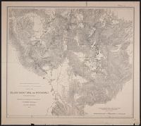
Description:
"56" printed in bottom right margin., Backed with linen. Stamp at top "10" crossed out with manuscript "No. 5" below., Relief shown by contours and spot heights., and Shows roads, springs, settlements, etc.
Publisher:
[The Survey],
Subject (Geographic):
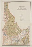
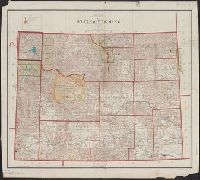
Idaho--Maps, Utah--Maps, and Wyoming--Maps
Subject (Name):
Bien, Julius, 1829-1909, Gannett, Henry, 1846-1914, and Hayden, F. V. (Ferdinand Vandeveer), 1829-1887
States of Massachusetts, Rhode Island and Connecticut
Description:
"1919.", "Advance sheet. Subject to correction.", Includes index of power stations., and Shows power plants and transmission lines.
Publisher:
U.S. Geological Survey,
Subject (Name):
Thomas, G. D
Subject (Topic):
Electric lines--Connecticut--Maps, Electric lines--Massachusetts--Maps, Electric lines--Rhode Island--Maps, Electric power transmission--Connecticut--Maps, Electric power transmission--Massachusetts--Maps, Electric power transmission--Rhode Island--Maps, Power-plants--Connecticut--Maps, Power-plants--Massachusetts--Maps, and Power-plants--Rhode Island--Maps
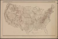
Indian reservations within the limits of the United States
Description:
Insets: Mission Ind. Res. in California. [Scale ca. 1:1,520,640] -- Indian Pueblo grants in New Mexico. [Scale ca. 1:2,534,400] -- Northeastern Oklahoma. [Scale ca. 1:1,520,640].
"For explanation see chapter on "Land Grants in aid of Internal Improvements.", "Julius Bien, Lithographer.", "The base chart was engraved for the Statistical Atlas of the United States.", and "To accompany report on the lands of the arid region of the U.S."
Publisher:
Dept. of the Interior,
Subject (Geographic):
United States--Maps
Subject (Name):
Geographical and Geological Survey of the Rocky Mountain Region (U.S.) and Powell, John Wesley, 1834-1902
"S.S. Burdett, Commissioner.", Prime meridans: Greenwich and Washington., Relief shown by hachures., and Shows drainage, county boundaries, railroads, railroad grants, military & Indian reservations, townships, etc.
At head of title : Department of the Interior, General Land Office, Hon. Binger Herman, commissioner. and Shows boundaries of water divisions and water districts.
"J.A. Williamson, Commissioner, Department of the Interior, General Land Office.", Gives longitude west from Greenwich and Washington., and Relief shown by hachures.
Publisher:
General Land Office, 1879 and Julius Bien, Photo lith & print.)
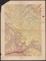
"Julius Bien & Co. Lith. N.Y.", "Surveyed in 1898.", Plate CXXXIX from the "Twenty-first annual report" of the U.S. Geological Survey, Part 5, Forest reserves (1900)., Relief shown by contours and spot heights., and Shows six classes of land cover.
Publisher:
The Survey,
Subject (Geographic):
Big Horn County (Wyo.)--Maps, Bighorn National Forest (Wyo.)--Maps, and Sheridan County (Wyo.)--Maps
Subject (Name):
Geological Survey (U.S.). Annual report and Tweedy, Frank, 1854-1937
Subject (Topic):
Forests and forestry--Wyoming--Big Horn County--Maps, Forests and forestry--Wyoming--Sheridan County--Maps, Land capability for agriculture--Wyoming--Big Horn County--Maps, and Land capability for agriculture--Wyoming--Sherida
Contour interval 100 feet. Datum is mean sea level., Includes examples of "Conventional signs" used on the map in the upper right margin., and Relief shown by contours and spot heights.
Publisher:
Engraved and printed by the U.S. Geological Survey,
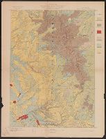
"Engraved Apr. 1901 by Julius Bien & Co.", "Surveyed, Plate CXLI from the "Twenty-first annual report" of the U.S. Geological Survey, Part 5, Forest reserves (1900)., Relief shown by contours and spot heights., and Shows four classes of land cover.
Publisher:
The Survey,
Subject (Geographic):
Black Hills National Forest (S.D. and Wyo.)--Maps and Weston County (Wyo.)--Maps
Subject (Name):
Geological Survey (U.S.). Annual report and Julius Bien & Co
Subject (Topic):
Forests and forestry--Wyoming--Weston County--Maps and Land capability for agriculture--Wyoming--Weston County--Maps
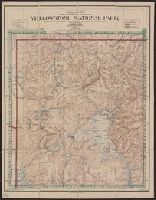
"1871.", "Approximate latitude of Park Pt., 44⁰23ʹ, approximate longitude of Park Pt., 110⁰20ʹ.", "Soundings are in fathoms.", At head of title: Department of the Interior, U.S. Geological Survey of the Territories., From the Survey's 5th annual report., and Relief shown by hachures and spot heights. Depths shown by soundings.
Publisher:
Geological Survey of the Territories,
Subject (Geographic):
Yellowstone Lake (Wyo.)--Maps and Yellowstone National Park--Maps
Subject (Name):
Elliott, Henry Wood, 1846-1930, Geological Survey of the Territories (U.S.), Hayden, F. V. (Ferdinand Vandeveer), 1829-1887, and Schönborn, A
Contour interval 100 feet. Datum is mean sea level., Dissected and mounted on linen., Includes examples of "Conventional signs" used on the map in the upper right margin., and Relief shown by contours and spot heights.
Publisher:
Engraved and printed by the U.S. Geological Survey,
"Julius Bien & Co. Lith. N.Y.", "Surveyed in 1897-99.", Plate CXL from the "Twenty-first annual report" of the U.S. Geological Survey, Part 5, Forest reserves (1900)., Relief shown by contours and spot heights., and Shows six classes of land cover.
Publisher:
The Survey,
Subject (Geographic):
Big Horn County (Wyo.)--Maps, Bighorn National Forest (Wyo.)--Maps, and Johnson County (Wyo.)--Maps
Subject (Name):
Geological Survey (U.S.). Annual report and Matthes, François, 1874-1948
Subject (Topic):
Forests and forestry--Wyoming--Big Horn County--Maps, Forests and forestry--Wyoming--Johnson County--Maps, Land capability for agriculture--Wyoming--Big Horn County--Maps, and Land capability for agriculture--Wyoming--Johnson
Copper River and adjacent territory, Geological Survey (U.S.). Report, Public resolution ; no. 25, 55th Congress, 3d session., and Its Report, Public resolution ; no. 25, 55th Congress, 3d session
Description:
Contour interval approximately 250 feet., Imperfect: Upper portion of map wanting. Dimensions 35 x 50 cm., and Relief shown by form lines, hachures, and spot heights.
Publisher:
The Survey,
Subject (Geographic):
Alaska--Maps, Chugach Mountains (Alaska)--Maps, and Copper River Region (Alaska)--Maps
Subject (Name):
Abercrombie, W. R.--(William Ralph),--b. 1857, Lowe, P. G, Mahlo, Emil, and Schrader, Frank C. (Frank Charles), 1860-1944
"Compiled from China Inland Mission map of the Chinese Empire (1911), Stanford's Map of the Siberian Railway (1919), Imperial Geological Survey map of Japan (1911) ..." and Also shows railways in Japan, Korea, northeastern Vietnam, and Siberia, USSR.
Publisher:
Department of State,
Subject (Geographic):
China--Maps
Subject (Name):
United States. Department of State
Subject (Topic):
Harbors--China--Maps, Railroads--China--Maps, and Railroads--East Asia--Maps
Insets: Alaska -- Philippine Islands -- Tutuila Group of the Samoan Islands -- Manua -- Guam or Cuajan Island -- Hawaiian Islands -- Porto Rico -- Panama Canal -- Isthmus of Panama showing location of canal. and Relief shown by hachures.
Publisher:
Dept. of the Interior, General Land Office,
Subject (Geographic):
United States--Discovery and exploration--Maps and United States--Maps
Subject (Name):
Bond, Frank, 1856-1940 and United States. General Land Office
"Jan. 1, 1915" in lower left margin., Irrigated areas shown on outline map of the United States. Explanation in margin., and This edition has county names printed in blue.
Publisher:
Office of Farm Management,
Subject (Geographic):
United States--Administrative and political divisions--Maps and United States--Maps
Insets: Alaska -- Philippine Islands -- Tutuila Group of the Samoan Islands -- Manua -- Guam or Cuajan Island -- Hawaiian Islands -- Porto Rico -- Panama Canal -- Isthmus of Panama showing location of canal. and Relief shown by hachures.
Publisher:
Dept. of the Interior, General Land Office,
Subject (Geographic):
United States--Discovery and exploration--Maps and United States--Maps
Subject (Name):
Bond, Frank, 1856-1940 and United States. General Land Office
Ms. notes in red and blue highlighting 500' and 1500' contours. Imperfect: Mutilated. Upper left corner missing, text wanting. and Relief shown by contours.
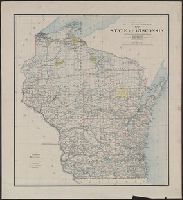
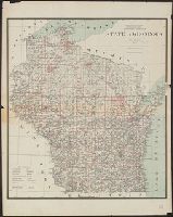
"Department of the Interior General Land Office Hon. S.W. Lamoreux, Commissioner.", "The Friedenwald Co. Photo-Lith, Balto.", and Indicates counties, county seats, cities, Indian reservations, U.S. land offices, railroads, light houses, and life saving stations.
Publisher:
General Land Office,
Subject (Geographic):
Wisconsin--Administrative and political divisions--Maps and Wisconsin--Maps
Subject (Name):
Friedenwald Co, Hendges, M, and King, Harry (Harold G. R.)
"Henry Gannett, chief topographer; R.U. Goode, geographer in charge; control by W.T. Griswold and U.S. Coast and Geodetic Survey; topography by G.E. Hyde and R.H. McKee; surveyed in 1894-95." and "Henry Gannett, geographer in charge; land classification by J.W. Rankine and G.H. Plummer; surveyed in 1897."
Publisher:
U.S.G.S.,
Subject (Geographic):
King County (Wash.)--Maps and Pierce County (Wash.)--Maps
Subject (Name):
Gannett, Henry, 1846-1914
Subject (Topic):
Forests and forestry--Washington (State)--King County--Maps, Forests and forestry--Washington (State)--Pierce County--Maps, Land use--Washington (State)--King County--Maps, and Land use--Washington (State)--Pierce County--Maps
"Surveyed in 1898, 1914,1915,1916, and 1919.", Key map of surveyors' areas of responsiblity in margin., and Relief shown by contours, land forms and spot heights.
Publisher:
Geological Survey,
Subject (Geographic):
Kuskokwim Bay Region (Alaska)--Maps and Kuskokwim River Region (Alaska)--Maps
Subject (Name):
Brooks, Alfred H. (Alfred Hulse), 1871-1924, Maddren, A. G, Post, W. S, and Sargent, Rufus Harvey, b. 1875
"Advance sheet. Subject to correction.", Includes inset index map showing areas mapped by individual topographers., Relief shown by contours and spot heights., and Topography by R.H. Sargent and C.G. Anderson.
Publisher:
Geological Survey,
Subject (Geographic):
Iditarod River Region (Alaska)--Maps, Innoko River Region (Alaska)--Maps, Kuskokwim Mountains (Alaska)--Maps, and Kuskokwin River Region (Alaska)--Maps
Subject (Name):
Anderson, C. G. (Cleland George), 1879- and Sargent, Rufus Harvey, b. 1875
"Surveyed in 1909 and 1913 ; topography by Alaskan Branch, R.H. Sargent, topographic engineer.", Includes regional location map., and Relief shown by contours and spot heights.
"Surveyed in 1903; additional areas from surveys made in 1900 and 1901 by U.S. Geological Survey". and Relief shown by contours; contour interval 200 feet.
Publisher:
U.S.G.S.,
Subject (Geographic):
Seward Peninsula (Alaska)--Maps
Subject (Name):
Brooks, Alfred H. (Alfred Hulse), 1871-1924 and Witherspoon, D. C
"Julius Bien & Co. Photo Lith. N.Y." in lower right margin., "Professional paper no. 45 PL. XI" in upper right margin., and Relief indicated by contours and notes.
"Engraved April 1901 by Julius Bien & Co., "Surveyed in 1898.", Plate CXXXIV from the "Twenty-first annual report" of the U.S. Geological Survey, Part 5, Forest reserves (1900)., Relief shown by contours and spot heights., and Shows six classes of land cover.
Publisher:
The Survey,
Subject (Geographic):
Spokane County (Wash.)--Maps
Subject (Name):
Geological Survey (U.S.). Annual report, Manning, Van H, and Plummer, Fred G. (Fred Gordon), 1864-1913
Subject (Topic):
Forests and forestry--Washington (State)--Spokane County--Maps and Land capability for agriculture--Washington (State)--Spokane County--Maps
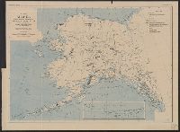
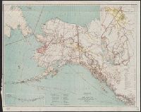
At head of title: Department of the Interior, General Land Office, Hon. Binger Hermann, Commissioner., Includes distance table and inset maps of "From Juneau to Forty Mile Creek" and the Aleutian Islands., Relief shown by shading and spot heights., and Shows land offices and reservations, transportation routes, mineral deposits, reported gold regions, isothermal lines, and religious missions by denomination.
Publisher:
General Land Office,
Subject (Geographic):
Alaska--Maps
Subject (Name):
Norris Peters Co and United States. General Land Office
"No. 20"--Upper right margin., "The Yukon River, ranges of mountains, shores of Norton Sound and many features of the interior from a reconnaissance by W.H. Dall, Director of the Scientific Corps, of the W.U. Tel. Expedition, 1865-1868.", and Inset: Aleutian Islands.
Publisher:
U.S. Coast Survey,
Subject (Geographic):
Alaska--Maps and Yukon Territory--Maps
Subject (Name):
Dall, William Healey, 1845-1927 and Lindenkohl, H. (Henry)
Insets: Aleutian Islands, Sitka, Juneau, Nome., Relief shown by shading and spot heights., and Shows forest reserves, Indian reservations, reindeer station reserves, military installations, etc.
Publisher:
General Land Office,
Subject (Geographic):
Alaska--Maps
Subject (Name):
Andrew B. Graham Co, Bond, Frank, 1856-1940, Hendges, M, and United States. General Land Office
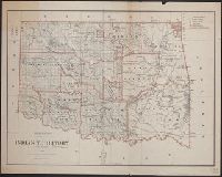
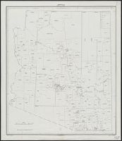
Includes dates of treaties with Indian nations., Library's copy annotated in black ink., Prime meridians: Washington and Greenwich., Relief shown by hachures., and Shows wagon roads, trails, railroads and natural features.
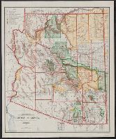
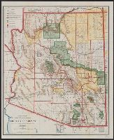
Includes inset of the Sonora railway and township diagram showing sections and quarter-sections., Prime meridians: Washington and Greenwich., Relief shown by shading., and Shows counties, Indian, forest, and military reserves, private land grants, and townships.
Publisher:
General Land Office,
Subject (Geographic):
Arizona--Administrative and political divisions--Maps and Arizona--Maps
Subject (Name):
Bond, Frank, 1856-1940, Norris Peters Co, and United States. General Land Office
Subject (Topic):
Forest reserves--Arizona--Maps and Indian reservations--Arizona--Maps
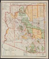
"Norris Peters Co., photo-litho.", Includes inset of the Sonora railway and township diagram., Prime meridians: Greenwich and Washington., Relief shown by shading., and Shows counties, forest, Indian, and military reserves, private land grants, roads, railways, township grid, etc.
Publisher:
General Land Office,
Subject (Geographic):
Arizona--Administrative and political divisions--Maps and Arizona--Maps
Subject (Name):
Berthrong, I. P, Norris Peters Co, and United States. General Land Office
Subject (Topic):
Forest reserves--Arizona--Maps and Indian reservations--Arizona--Maps
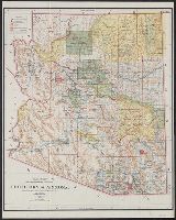
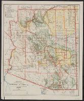
Relief shown by shading, hachures, and spot heights. and Shows counties, private land grants, national forests, Indian reservations, reclamation projects, military reservations, national parks, townships, etc.
Publisher:
U.S. Dept. of the Interior, General Land Office,
Subject (Geographic):
Arizona--Administrative and political divisions--Maps
Subject (Name):
Gales, T. W
Subject (Topic):
Forest reserves--Arizona--Maps and Indian reservations--Arizona--Maps
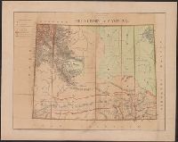
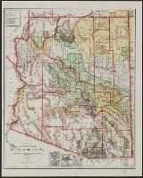
Prime meridians: Greenwich and Washington., Relief shown by shading., and Shows counties, Indian, military, and forest reservations, private claims, and townships.
Publisher:
General Land Office,
Subject (Geographic):
Arizona--Administrative and political divisions--Maps and Arizona--Maps
Subject (Topic):
Forest reserves--Arizona--Maps and Indian reservations--Arizona--Maps
Imperfect: only "Sheet No. 3", sheets 1 and 2 wanting., Relief shown by contours and spot heights., Sheets issued in various editions and reprints., and Text and ill. on verso.
"Norris Peters Co., photo-litho.", Includes inset of the Sonora railway and township diagram., Prime meridians: Greenwich and Washington., Relief shown by shading., and Shows counties, forest, Indian, and military reserves, private land grants, roads, railways, township grid, etc.
Publisher:
General Land Office,
Subject (Geographic):
Arizona--Administrative and political divisions--Maps and Arizona--Maps
Subject (Name):
Berthrong, I. P, Norris Peters Co, and United States. General Land Office
Subject (Topic):
Forest reserves--Arizona--Maps and Indian reservations--Arizona--Maps
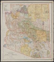
"Printed by the U.S. Geological Survey.", Includes insets of Tucson, Phoenix, connections to railroads in Arizona, and township diagram., Prime meridians: Greenwich and Washington., Relief shown by shading., and Shows counties, forest, Indian, and military national reserves, roads, railways, township grid, etc.
Publisher:
General Land Office,
Subject (Geographic):
Arizona--Administrative and political divisions--Maps and Arizona--Maps
Subject (Name):
Bauman, Wm. (William), Berthrong, I. P, and United States. General Land Office
Subject (Topic):
Forest reserves--Arizona--Maps and Indian reservations--Arizona--Maps
Includes inset of the Sonora railway and township diagram., Prime meridians: Greenwich and Washington., Relief shown by shading., and Shows counties, Indian, forest, and military reserves, private land grants, and townships.
Publisher:
The Office,
Subject (Geographic):
Arizona--Administrative and political divisions--Maps and Arizona--Maps
Subject (Name):
Bond, Frank, 1856-1940 and United States. General Land Office
Subject (Topic):
Forest reserves--Arizona--Maps and Indian reservations--Arizona--Maps
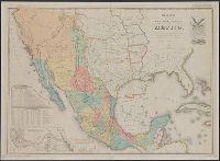
Department of State publication ; 803. and Department of State, map series ; no. 5 (Publication no. 803)
Description:
"Reproduced in 1935 to accompany ʻTreaties and other international acts of the United States of America,ʾ Volume 5. See Document 129.", "The earliest of five or more 1847 editions. The copy added to the Treaty of Guadalupe Hidalgo of February 2, 1848, in the archives of the Department of State.", Includes table of distances, table of statistics, "Profile of the route between Mexico and Vera Cruz," and "Profile of the route b[e]tween Mexico and Acapulco.", Insets: Carta de los caminos &c. desde Vera Cruz y Alvarado a Méjico -- Map showing the battle grounds of the 8th and 9th May 1846 -- Chart of the bay of Vera Cruz., Prime meridian: Washington., and Relief shown by hachures and spot heights.
"Surveyed in 1911.", Includes "Index to shafts" listed alphabetically and by number on map., Map showing responsibility for topography in lower margin., and Relief shown by contours and spot heights.
Publisher:
The Survey,
Subject (Geographic):
Leadville (Colo.)--Maps
Subject (Name):
Davis, E. P., Marshall, R. B. (Robert Bradford), 1867-1949., Robertson, R. B., Semper, C. H., Tatum, Sledge., and Taylor, S. E.
Subject (Topic):
Mines and mineral resources--Colorado--Leadville--Maps.
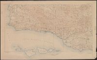
"Electrotype Copy No. 7 U.S.C.S.", "Issued December 187, "Redd. Drng. by C. Mahon & G. Farquahar.", and Includes inset horizontal views: Entrance to Salem by main channel, Baker's Island Lights ... -- Entrance to Salem by Cat Island channel, Marblehead Light ...
Publisher:
The Survey,
Subject (Geographic):
Salem Region (Mass.)--Maps
Subject (Name):
Bradford, J. S, Dankworth, Frederick, b. ca. 1804, Hilgard, J. E. (Julius Erasmus), 1825-1891, McBlair, C. H, McCoy, G, Temple, W. G, and Whiting, Henry L
Subject (Topic):
Harbors--Massachusetts--Salem--Maps and Nautical charts--Massachusetts--Salem Region
"Engd. by A. Petersen & E.A. Maedel" lower right and MUDDGDC T 11.1:857/(I).8: "No.10" printed outside upper left margin. "Transferred & printed by Lang & Lang, Lith. 66 Fulton St., N.Y." printed outside upper right margin; otherwise identical to 764cea 1857.
Publisher:
U.S. Coast Survey,
Subject (Geographic):
Woods Hole (Mass.)--Maps
Subject (Topic):
Harbors--Massachusetts--Woods Hole--Maps and Nautical charts--Massachusetts--Woods Hole