Search
You Searched For
Search Results
- Creator:
- National Geographic Society (U.S.). Cartographic Section
- Published / Created:
- 1954
- Call Number:
- 844 1954
- Container / Volume:
- BRBL_00603
- Image Count:
- 1
- Resource Type:
- Maps, Atlases & Globes
- Found in:
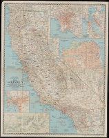
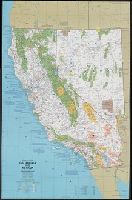
- Beinecke Rare Book and Manuscript Library > A map of California : with descriptive notes / compiled and drawn in the Cartographic Section of the National Geographic Society ; James M. Darley, chief cartographer.
- Creator:
- National Geographic Society (U.S.). Cartographic Section
- Published / Created:
- 1954
- Call Number:
- 844 1954
- Container / Volume:
- BRBL_00603
- Image Count:
- 1
- Resource Type:
- Maps, Atlases & Globes
- Found in:
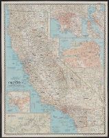
- Beinecke Rare Book and Manuscript Library > A map of California : with descriptive notes / compiled and drawn in the Cartographic Section of the National Geographic Society ; James M. Darley, chief cartographer.
- Creator:
- Jones, Lewis A
- Published / Created:
- 1915
- Call Number:
- 794gcf B48 1914
- Container / Volume:
- BRBL_00521
- Image Count:
- 11
- Resource Type:
- Maps, Atlases & Globes
- Found in:
- Beinecke Rare Book and Manuscript Library > A report on the methods and cost of reclaiming the overflowed lands along the Big Black River, Mississippi / by Lewis A. Jones ; assisted by W.J. Schlick and C.E. Ramser.
- Creator:
- United States. Army Air Forces
- Published / Created:
- 1944
- Call Number:
- 50 1945C
- Container / Volume:
- BRBL_00273
- Image Count:
- 2
- Resource Type:
- Maps, Atlases & Globes
- Found in:
- Beinecke Rare Book and Manuscript Library > AAF cloth chart [cartographic material] : no. C41, Mindoro Island / Army Map Service U.S. Army.
- Creator:
- U.S. Coast and Geodetic Survey
- Published / Created:
- 1944
- Call Number:
- 50 1945I
- Container / Volume:
- BRBL_00273
- Image Count:
- 2
- Resource Type:
- Maps, Atlases & Globes
- Found in:
- Beinecke Rare Book and Manuscript Library > AAF cloth chart. No. 133, Kun-Ming, Yunnan, China to Chabua, Assam, India Forces / prepared under the direction of the Commanding General, Army Air Forces, for the Aeronautical Chart Service, by the U.S. Coast and Geodetic Survey, Washington, D.C., Januar
- Creator:
- U.S. Lake Survey
United States. Aeronautical Chart Service
United States. Army Map Service
- Published / Created:
- 1944
- Call Number:
- 275 1944A
- Container / Volume:
- BRBL_00023B
- Image Count:
- 1
- Resource Type:
- Maps, Atlases & Globes
- Found in:
- Beinecke Rare Book and Manuscript Library > AAF cloth chart. No. C-47. South Borneo.
- Creator:
- U.S. Lake Survey
United States. Aeronautical Chart Service
United States. Army Map Service
- Published / Created:
- 1944
- Call Number:
- 275 1944A
- Container / Volume:
- BRBL_00023B
- Image Count:
- 1
- Resource Type:
- Maps, Atlases & Globes
- Found in:
- Beinecke Rare Book and Manuscript Library > AAF cloth chart. No. C-48. West Java.
- Creator:
- National Geographic Society (U.S.). Cartographic Section
- Published / Created:
- c1943.
- Call Number:
- 60 1943
- Container / Volume:
- BRBL_00329
- Image Count:
- 1
- Resource Type:
- Maps, Atlases & Globes
- Found in:
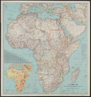
- Beinecke Rare Book and Manuscript Library > Africa / compiled and drawn in the Cartographic Section of the National Geographic Society ; James M. Darley, chief cartographer.
- Creator:
- National Geographic Society (U.S.). Cartographic Section
- Published / Created:
- c1943.
- Call Number:
- 60 1943
- Container / Volume:
- BRBL_00329
- Image Count:
- 1
- Resource Type:
- Maps, Atlases & Globes
- Found in:
- Beinecke Rare Book and Manuscript Library > Africa / compiled and drawn in the Cartographic Section of the National Geographic Society ; James M. Darley, chief cartographer.
- Creator:
- Great Britain. Royal Air Force. Central Interpretation Unit
- Published / Created:
- 1943
- Call Number:
- 475 1944
- Container / Volume:
- BRBL_00262
- Image Count:
- 1
- Resource Type:
- Maps, Atlases & Globes
- Found in:
- Beinecke Rare Book and Manuscript Library > Albania 1:10,000. Vlonë (Valona) city plan / compiled and drawn by C.I.U. 1943 [cartographic material].
- Published / Created:
- 1918
- Call Number:
- 11hcf 1919-20
- Container / Volume:
- BRBL_00010J
- Image Count:
- 1
- Resource Type:
- Maps, Atlases & Globes
- Found in:
- Beinecke Rare Book and Manuscript Library > Albania.
- Creator:
- United States. Office of Strategic Services. Research and Analysis Branch
- Published / Created:
- 1943
- Call Number:
- 652gm 1943
- Container / Volume:
- BRBL_00343
- Image Count:
- 1
- Resource Type:
- Maps, Atlases & Globes
- Found in:
- Beinecke Rare Book and Manuscript Library > Belgian Congo, roads, railroads and navigable waterways / drawn in the Branch of Research and Analysis, OSS.
- Creator:
- Great Britain. War Office. General Staff. Geographical Section
- Published / Created:
- 1943
- Call Number:
- 409 C17 1943
- Container / Volume:
- BRBL_00240
- Image Count:
- 1
- Resource Type:
- Maps, Atlases & Globes
- Found in:
- Beinecke Rare Book and Manuscript Library > Carbonia [cartographic material] / photolithographed by War Office, 1943.
- Creator:
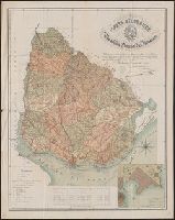
- Reyes, José Maria, 1803-1864
- Published / Created:
- c1893.
- Call Number:
- 93 1893
- Container / Volume:
- BRBL_00674
- Image Count:
- 1
- Resource Type:
- Maps, Atlases & Globes
- Found in:
- Beinecke Rare Book and Manuscript Library > Carta geográfica de la Republica Oriental del Uruguay [cartographic material] / reduccion dela del general ingeniero Don José M. Reyes. Aumentada y correjida en parte con antecedentes del archivo dela direccion gral de obras publicas por el vocal dela s
- Creator:
- Great Britain. War Office. General Staff. Geographical Section
United States. Army Map Service
- Published / Created:
- 1942
- Call Number:
- 354 1942
- Container / Volume:
- BRBL_00112
- Image Count:
- 1
- Resource Type:
- Maps, Atlases & Globes
- Found in:
- Beinecke Rare Book and Manuscript Library > Caucasia and neighbouring territories.
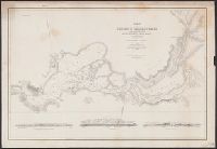
- Creator:
- Ringgold, Cadwalader, 1802-1867
- Published / Created:
- [1851?]
- Call Number:
- 844cea Sa52 1850C
- Container / Volume:
- BRBL_00614
- Image Count:
- 1
- Resource Type:
- Maps, Atlases & Globes
- Found in:
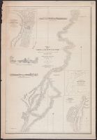
- Beinecke Rare Book and Manuscript Library > Chart of Suisun & Vallejo Bays, with the confluence of the rivers Sacramento and San Joaquin : California / by Cadwalader Ringgold, Commander, U.S. Navy ; assisted by Sam. R. Knox, Lieut., U.S.N. and Wm. P. Humphreys & J.H. Rowe, engineers, 1850.
- Creator:
- Ringgold, Cadwalader, 1802-1867
- Published / Created:
- [1851?]
- Call Number:
- 844cea Sa52 1850C
- Container / Volume:
- BRBL_00614
- Image Count:
- 1
- Resource Type:
- Maps, Atlases & Globes
- Found in:
- Beinecke Rare Book and Manuscript Library > Chart of Suisun & Vallejo Bays, with the confluence of the rivers Sacramento and San Joaquin : California / by Cadwalader Ringgold, Commander, U.S. Navy ; assisted by Sam. R. Knox, Lieut., U.S.N. and Wm. P. Humphreys & J.H. Rowe, engineers, 1850.
- Creator:
- Ringgold, Cadwalader, 1802-1867
- Published / Created:
- [1851?]
- Call Number:
- 844cea Sa52 1850A
- Container / Volume:
- BRBL_00614
- Image Count:
- 1
- Resource Type:
- Maps, Atlases & Globes
- Found in:
- Beinecke Rare Book and Manuscript Library > Chart of the Farallones and entrance to the bay of San Francisco : California / by Cadwalader Ringgold, Commander, U.S. Navy ; assisted by Simon F. Blunt, Lieut., U.S. Navy, 1850.
- Creator:
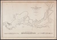
- Ringgold, Cadwalader, 1802-1867
- Published / Created:
- [1851?]
- Call Number:
- 844cea Sa52 1850D
- Container / Volume:
- BRBL_00614
- Image Count:
- 1
- Resource Type:
- Maps, Atlases & Globes
- Found in:
- Beinecke Rare Book and Manuscript Library > Chart of the Sacramento River from Suisun City to the American River : California / by Cadwalader Ringgold, Commander, U.S. Navy ; assisted by Edwin Cullberg, Lieut. of the Hydrotechnic Corps, Swedish Navy, and T.A. Emmet, civil engineer, 1850.
- Creator:
- Ringgold, Cadwalader, 1802-1867
- Published / Created:
- [1851?]
- Call Number:
- 844cea Sa52 1850B
- Container / Volume:
- BRBL_00614
- Image Count:
- 1
- Resource Type:
- Maps, Atlases & Globes
- Found in:
- Beinecke Rare Book and Manuscript Library > Chart of the bay of San Pablo, Straits of Carquines, and part of the bay of San Francisco : California / by Cadwalader Ringgold, Commander, U.S. Navy ; assisted by Simon F. Blunt, Lieut., U.S.N., 1850.
- Creator:
- National Geographic Society (U.S.). Cartographic Section
- Published / Created:
- 1945
- Call Number:
- 56 1945
- Container / Volume:
- BRBL_00296
- Image Count:
- 1
- Resource Type:
- Maps, Atlases & Globes
- Found in:
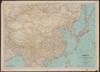
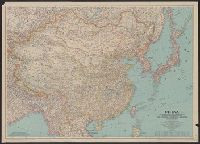
- Beinecke Rare Book and Manuscript Library > China [cartographic material] / compiled and drawn in the Cartographic Section of the National Geographic Society for the National Geographic Magazine ; James M. Darley, chief cartographer.
- Creator:
- National Geographic Society (U.S.). Cartographic Section
- Published / Created:
- 1945
- Call Number:
- 56 1945
- Container / Volume:
- BRBL_00296
- Image Count:
- 1
- Resource Type:
- Maps, Atlases & Globes
- Found in:
- Beinecke Rare Book and Manuscript Library > China [cartographic material] / compiled and drawn in the Cartographic Section of the National Geographic Society for the National Geographic Magazine ; James M. Darley, chief cartographer.
- Creator:
- United States. Army Map Service
- Published / Created:
- 1945
- Call Number:
- 56 F73 1945
- Container / Volume:
- BRBL_00296
- Image Count:
- 1
- Resource Type:
- Maps, Atlases & Globes
- Found in:
- Beinecke Rare Book and Manuscript Library > China city plans 1:12,500. Fu-chou and Nan-ta̓i / prepared under the direction of the Chief of Engineers by the Army Map Service (AM) ... 1945 [cartographic material].
- Creator:
- United States. Army Map Service
- Published / Created:
- 1942
- Call Number:
- 6547 C74 1945
- Container / Volume:
- BRBL_00344
- Image Count:
- 1
- Resource Type:
- Maps, Atlases & Globes
- Found in:
- Beinecke Rare Book and Manuscript Library > City plan of Conakry.
- Creator:
- National Geographic Society (U.S.). Cartographic Division
- Published / Created:
- c1978.
- Call Number:
- 844 1978
- Container / Volume:
- BRBL_00603
- Image Count:
- 2
- Resource Type:
- Maps, Atlases & Globes
- Found in:
- Beinecke Rare Book and Manuscript Library > Close-up: U.S.A., California and Nevada / produced by the Cartographic Division, National Geographic Society ; William T. Peele, chief cartographer, David W. Cook, associate chief cartographer.
- Creator:
- National Geographic Society (U.S.). Cartographic Division
- Published / Created:
- c1977.
- Call Number:
- 7821 1977
- Container / Volume:
- BRBL_00506
- Image Count:
- 2
- Resource Type:
- Maps, Atlases & Globes
- Found in:
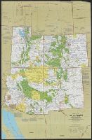
- Beinecke Rare Book and Manuscript Library > Close-up: U.S.A., the Southwest / produced by the Cartographic Division, National Geographic Society ; William T. Peele, chief cartographer ; Richard K. Rogers, assistant chief cartographer.
- Creator:
- United States. Army Map Service
- Published / Created:
- 1943
- Call Number:
- 38 C71 1943
- Container / Volume:
- BRBL_00157
- Image Count:
- 1
- Resource Type:
- Maps, Atlases & Globes
- Found in:
- Beinecke Rare Book and Manuscript Library > Colmar [cartographic material] : city plan / prepared under the direction of the Chief of Engineers, U.S. Army, 1943.
- Creator:
- U.S. Coast and Geodetic Survey
- Published / Created:
- 1900
- Call Number:
- 767cea 1900
- Container / Volume:
- BRBL_00476
- Image Count:
- 1
- Resource Type:
- Maps, Atlases & Globes
- Found in:
- Beinecke Rare Book and Manuscript Library > Connecticut River, Deep River to Higganum, Connecticut / U.S. Coast and Geodetic Survey.
- Published / Created:
- [190?]
- Call Number:
- 28hc 1900A
- Container / Volume:
- BRBL_00024
- Image Count:
- 1
- Resource Type:
- Maps, Atlases & Globes
- Found in:
- Beinecke Rare Book and Manuscript Library > Copy of map furnished to commanding officers, 2nd Brig., 2nd Div., 8th Army Corps, on August 12, 1898.
- Creator:
- United States. Army Map Service
- Published / Created:
- [1945]
- Call Number:
- 3897gm 1945
- Image Count:
- 1
- Resource Type:
- Maps, Atlases & Globes
- Found in:
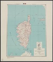
- Beinecke Rare Book and Manuscript Library > Corsica [cartographic material] : special strategic map / compiled by the Army Map Service.
- Creator:
- Great Britain. Inter-service Topographical Dept
- Published / Created:
- 1943
- Call Number:
- 38 D34 1944
- Container / Volume:
- BRBL_00157
- Image Count:
- 1
- Resource Type:
- Maps, Atlases & Globes
- Found in:
- Beinecke Rare Book and Manuscript Library > Deauville-Trouville [cartographic material] / compiled and drawn by Inter-Service Topographical Dept. ; produced under the Superintendence of Vice-Admiral John Edgell, hydrographer.
- Creator:
- Great Britain. Army. Middle East Forces
- Published / Created:
- 1943
- Call Number:
- 69 D44 1943
- Container / Volume:
- BRBL_00352
- Image Count:
- 1
- Resource Type:
- Maps, Atlases & Globes
- Found in:
- Beinecke Rare Book and Manuscript Library > Derna, city plan.
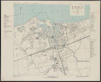
- Creator:
- United States. Army Map Service
- Published / Created:
- 1942
- Call Number:
- 35fb 1939
- Container / Volume:
- BRBL_00103
- Image Count:
- 1
- Resource Type:
- Maps, Atlases & Globes
- Found in:
- Beinecke Rare Book and Manuscript Library > Divisions of the Union of Soviet Socialist Republics as of September, 1939 / compiled and drawn by Army Map Service.
- Creator:
- Great Britain. Inter-service Topographical Dept
- Published / Created:
- 1943, 1944 printing.
- Call Number:
- 38 D742 1944
- Container / Volume:
- BRBL_00157
- Image Count:
- 1
- Resource Type:
- Maps, Atlases & Globes
- Found in:
- Beinecke Rare Book and Manuscript Library > Douarnenez-Tréboul [cartographic material] : plan of port and town / compiled and drawn by Inter-Service Topographical Dept. ; produced under the Superintendence of Vice-Admiral John Edgell, hydrographer.
- Creator:
- Great Britain. Inter-service Topographical Dept
- Published / Created:
- 1943
- Call Number:
- 38 D92 1943
- Container / Volume:
- BRBL_00157
- Image Count:
- 1
- Resource Type:
- Maps, Atlases & Globes
- Found in:
- Beinecke Rare Book and Manuscript Library > Dunkerque [cartographic material] : plan of port & town / compiled and drawn by Inter-Service Topographical Dept. ; produced under the Superintendence of Vice-Admiral John Edgell, hydrographer.
- Creator:
- United States. Army Map Service
- Published / Created:
- 1945
- Call Number:
- 50 1945L
- Container / Volume:
- BRBL_00273
- Image Count:
- 2
- Resource Type:
- Maps, Atlases & Globes
- Found in:
- Beinecke Rare Book and Manuscript Library > Eastern Asia 1:1,000,000 AAF cloth chart. Hakodate. NK54.
- Creator:
- United States. Army Map Service
- Published / Created:
- 1944
- Call Number:
- 50 1945N
- Container / Volume:
- BRBL_00273
- Image Count:
- 2
- Resource Type:
- Maps, Atlases & Globes
- Found in:
- Beinecke Rare Book and Manuscript Library > Eastern Asia 1:1,000,000 AAF cloth chart. Ryojun NJ-51.
- Creator:
- United States. Army Map Service
- Published / Created:
- 1943
- Call Number:
- 556 1944D
- Container / Volume:
- BRBL_00293
- Image Count:
- 2
- Resource Type:
- Maps, Atlases & Globes
- Found in:
- Beinecke Rare Book and Manuscript Library > Eastern Asia 1:1,000,000 [cartographic material] : AAF cloth chart. Hakodate. NK54.
- Published / Created:
- 1944
- Call Number:
- 38gmb 1944
- Container / Volume:
- BRBL_00170
- Image Count:
- 1
- Resource Type:
- Maps, Atlases & Globes
- Found in:
- Beinecke Rare Book and Manuscript Library > Europe road map 1:200,000. 60, Le Mans.
- Published / Created:
- 1921
- Call Number:
- 11hc 1919Z
- Container / Volume:
- BRBL_00010I
- Image Count:
- 1
- Resource Type:
- Maps, Atlases & Globes
- Found in:
- Beinecke Rare Book and Manuscript Library > Extract of Mezieres-Verdun-Metz-Longwy : Meuse-Argonne offensive, map showing daily position of front line Map room G-3, G.H.Q. May 24, 1919.
- Creator:
- National Geographic Society (U.S.). Cartographic Division
- Published / Created:
- 1984
- Call Number:
- 80 1984
- Container / Volume:
- BRBL_00536
- Image Count:
- 2
- Resource Type:
- Maps, Atlases & Globes
- Found in:
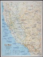
- Beinecke Rare Book and Manuscript Library > Far West / produced by the Cartographic Division, National Geographic Society.
- Creator:
- United States. Army. Corps of Engineers
- Published / Created:
- 1942
- Call Number:
- 67 F31 1942
- Container / Volume:
- BRBL_00348
- Image Count:
- 1
- Resource Type:
- Maps, Atlases & Globes
- Found in:
- Beinecke Rare Book and Manuscript Library > Fedhala, city plan / prepared under the direction of the chief of engineers, U.S. Army.
- Creator:
- Great Britain. Inter-service Topographical Dept
- Published / Created:
- 1943, 1944 printing.
- Call Number:
- 38 F31 1944
- Container / Volume:
- BRBL_00157
- Image Count:
- 1
- Resource Type:
- Maps, Atlases & Globes
- Found in:
- Beinecke Rare Book and Manuscript Library > Fécamp, plan of port and town [cartographic material] / compiled and drawn by Inter-Service Topographical Dept. ; produced under the Superintendence of Vice-Admiral John Edgell, hydrographer.
- Creator:
- United States. Army Map Service
- Published / Created:
- [1945]
- Call Number:
- 575 K63 1945
- Container / Volume:
- BRBL_00312
- Image Count:
- 1
- Resource Type:
- Maps, Atlases & Globes
- Found in:
- Beinecke Rare Book and Manuscript Library > Formosa city plans 1:10,000. Kiirun / prepared under the direction of Chief of Engineers by the Army Map Service (AM), U.S. Army.
- Creator:
- United States. Army Map Service
- Published / Created:
- [1945]
- Call Number:
- 575 T135 1945
- Container / Volume:
- BRBL_00313
- Image Count:
- 1
- Resource Type:
- Maps, Atlases & Globes
- Found in:
- Beinecke Rare Book and Manuscript Library > Formosa city plans 1:10,000. Taitō / prepared under the direction of the Chief of Engineers by the Army Map Service (AM), U.S. Army.
- Creator:
- United States. Army Map Service
- Published / Created:
- [1944]
- Call Number:
- 575 T63 1945
- Container / Volume:
- BRBL_00313
- Image Count:
- 1
- Resource Type:
- Maps, Atlases & Globes
- Found in:
- Beinecke Rare Book and Manuscript Library > Formosa city plans 1:10,000. Toshien / prepared under the direction of the Chief of Engineers by the Army Map Service (AM), U.S. Army.
- Creator:
- United States. Army Map Service
- Published / Created:
- [1944]
- Call Number:
- 575 C43 1944
- Container / Volume:
- BRBL_00312
- Image Count:
- 1
- Resource Type:
- Maps, Atlases & Globes
- Found in:
- Beinecke Rare Book and Manuscript Library > Formosa city plans 1:8,000. Chikunan / prepared under the direction of the Chief of Engineers by the Army Map Service (AM), U.S. Army.
- Published / Created:
- 1943
- Call Number:
- 38FB 1943a
- Container / Volume:
- BRBL_00170
- Image Count:
- 2
- Resource Type:
- Maps, Atlases & Globes
- Found in:
- Beinecke Rare Book and Manuscript Library > France : Board of economic warfare.
- Creator:
- La Rocque, George A., 1908-
- Published / Created:
- 1966
- Call Number:
- 817cbj 1966
- Container / Volume:
- BRBL_00564
- Image Count:
- 1
- Resource Type:
- Maps, Atlases & Globes
- Found in:
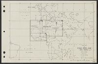
- Beinecke Rare Book and Manuscript Library > General availability of ground water and depth to water level in the Missouri River Basin / by G.A. La Rocque, Jr.
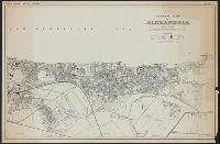
- Creator:
- Egypt. Maṣlaḥat al-Misāḥah
- Published / Created:
- 1942
- Call Number:
- 61 1943B
- Container / Volume:
- BRBL_00331
- Image Count:
- 1
- Resource Type:
- Maps, Atlases & Globes
- Found in:
- Beinecke Rare Book and Manuscript Library > General map of Alexandria.
- Published / Created:
- [1896?]
- Call Number:
- 36hc 1896
- Container / Volume:
- BRBL_00133
- Image Count:
- 1
- Resource Type:
- Maps, Atlases & Globes
- Found in:
- Beinecke Rare Book and Manuscript Library > German Maneuvers, 1896.
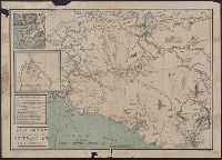
- Creator:
- United States. Office of Strategic Services. Research and Analysis Branch
- Published / Created:
- 1944
- Call Number:
- 36gm 1944A
- Container / Volume:
- BRBL_00130
- Image Count:
- 1
- Resource Type:
- Maps, Atlases & Globes
- Found in:
- Beinecke Rare Book and Manuscript Library > Germany : Super-Highway (Reichsautobahn) / compiled and drawn in the Branch of Research and Analysis, OSS.
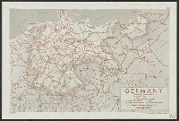
- Creator:
- Darley, James M. (James Morrison)
National Geographic Society (U.S.). Cartographic Section
- Published / Created:
- c1944.
- Call Number:
- 36 1944C
- Container / Volume:
- BRBL_00121
- Image Count:
- 1
- Resource Type:
- Maps, Atlases & Globes
- Found in:
- Beinecke Rare Book and Manuscript Library > Germany and its approaches : with international boundaries as of September 1, 1939, the day Germany invaded Poland and, in red, boundaries as of January 1, 1938, before Germany seized Austria and Czechoslovakia / compiled and drawn in the Cartographic Sec
- Creator:
- Tyrrell, Joseph Burr, 1858-1957
- Published / Created:
- c1897
- Call Number:
- 848 1897E
- Container / Volume:
- BRBL_00630
- Image Count:
- 1
- Resource Type:
- Maps, Atlases & Globes
- Found in:
- Beinecke Rare Book and Manuscript Library > Gold region approaches by Copper River and the Dalton Trail / compiled from latest U.S. surveys, British authorities and other sources by J.B. Tyrrell.
- Creator:
- United States. Army Map Service
- Published / Created:
- 1944
- Call Number:
- 50 1945K
- Container / Volume:
- BRBL_00273
- Image Count:
- 2
- Resource Type:
- Maps, Atlases & Globes
- Found in:
- Beinecke Rare Book and Manuscript Library > Harbin / prepared under the direction of the Chief of Engineers, U.S. Army, by the Army Map Service.
- Creator:
- United States. Army Map Service
- Published / Created:
- 1944
- Call Number:
- 556 1943
- Container / Volume:
- BRBL_00293
- Image Count:
- 2
- Resource Type:
- Maps, Atlases & Globes
- Found in:
- Beinecke Rare Book and Manuscript Library > Harbin [cartographic material] / prepared under the direction of the Chief of Engineers, U.S. Army, by the Army Map Service.
- Creator:
- United States. Office of Strategic Services. Research and Analysis Branch
- Published / Created:
- 1944
- Call Number:
- 5681 1944A
- Container / Volume:
- BRBL_00300
- Image Count:
- 1
- Resource Type:
- Maps, Atlases & Globes
- Found in:
- Beinecke Rare Book and Manuscript Library > Hong Kong-Kowloon area : map no. I.
- Creator:
- United States. Office of Strategic Services. Research and Analysis Branch
- Published / Created:
- 1944
- Call Number:
- 5681 1944
- Container / Volume:
- BRBL_00300
- Image Count:
- 1
- Resource Type:
- Maps, Atlases & Globes
- Found in:
- Beinecke Rare Book and Manuscript Library > Hong Kong-Kowloon area : map no. III.
- Creator:
- Great Britain. War Office
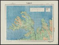
United States. Army Map Service
- Published / Created:
- 1941-
- Call Number:
- 343CBF 1941
- Container / Volume:
- BRBL_00093
- Image Count:
- 4
- Resource Type:
- Maps, Atlases & Globes
- Found in:
- Beinecke Rare Book and Manuscript Library > Iceland 1:500,000.
- Creator:
- United States. Army Map Service
- Published / Created:
- [1943?]
- Call Number:
- 60gmb 1945
- Container / Volume:
- BRBL_00330
- Image Count:
- 2
- Resource Type:
- Maps, Atlases & Globes
- Found in:
- Beinecke Rare Book and Manuscript Library > Index map of Africa road maps, scale various.
- Creator:
- United States. Army. Corps of Engineers
- Published / Created:
- 1943
- Call Number:
- 40 Sa65 1943
- Image Count:
- 1
- Resource Type:
- Maps, Atlases & Globes
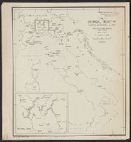
- Found in:
- Beinecke Rare Book and Manuscript Library > Italy 1:10,000. Sapri city plan / prepared under the direction of the Chief of Engineers, U.S. Army, Washington, D.C [cartographic material].
- Creator:
- United States. Army. Corps of Engineers
- Published / Created:
- 1943
- Call Number:
- 40 V65 1943
- Image Count:
- 1
- Resource Type:
- Maps, Atlases & Globes
- Found in:
- Beinecke Rare Book and Manuscript Library > Italy 1:10,000. Viareggio city plan / prepared under the direction of the Chief of Engineers, U.S. Army, Washington, D.C [cartographic material].
- Creator:
- United States. Army. Corps of Engineers
- Published / Created:
- 1943
- Call Number:
- 40 C442 1943
- Container / Volume:
- BRBL_00206
- Image Count:
- 1
- Resource Type:
- Maps, Atlases & Globes
- Found in:
- Beinecke Rare Book and Manuscript Library > Italy 1:7,500. Chioggia city plan / prepared under the direction of the Chief of Engineers, U.S. Army. 1943 [cartographic material].
- Creator:
- United States. Army. Corps of Engineers
- Published / Created:
- 1943
- Call Number:
- 40 Sc47 1943
- Container / Volume:
- BRBL_00219
- Image Count:
- 1
- Resource Type:
- Maps, Atlases & Globes
- Found in:
- Beinecke Rare Book and Manuscript Library > Italy 1:7,500. Scilla city plan / prepared under the direction of the Chief of Engineers, U.S. Army, Washington, D.C [cartographic material].
- Creator:
- United States. Office of Strategic Services. Research and Analysis Branch
- Published / Created:
- 1943
- Call Number:
- 40gfb 1943
- Container / Volume:
- BRBL_00229
- Image Count:
- 1
- Resource Type:
- Maps, Atlases & Globes
- Found in:
- Beinecke Rare Book and Manuscript Library > Italy Chemical Industry: Location of principal plants / James H. Shoemaker Lt. Col.
- Creator:
- United States. Army Map Service
- Published / Created:
- 1944
- Call Number:
- 57gmb 1943
- Container / Volume:
- BRBL_00307
- Image Count:
- 2
- Resource Type:
- Maps, Atlases & Globes
- Found in:
- Beinecke Rare Book and Manuscript Library > Japan (South) : special strategic map / compiled by the Army Map Service, May 1943.
- Creator:
- United States. Army Map Service
- Published / Created:
- 1945
- Call Number:
- 57gm 1945B
- Container / Volume:
- BRBL_00306
- Image Count:
- 1
- Resource Type:
- Maps, Atlases & Globes
- Found in:
- Beinecke Rare Book and Manuscript Library > Japan (south) special strategic map / prepared under the direction of the Chief of Engineers, U.S. Army, Washington, D.C. Compiled by the Army Map Service.
- Creator:
- National Geographic Society (U.S.). Cartographic Division
- Published / Created:
- 1945
- Call Number:
- 57 1945
- Container / Volume:
- BRBL_00303
- Image Count:
- 1
- Resource Type:
- Maps, Atlases & Globes
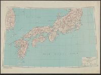
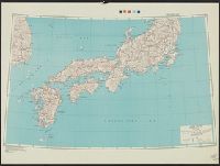
- Found in:
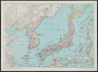
- Beinecke Rare Book and Manuscript Library > Japan and Korea / compiled and drawn in the Cartographic Section of the National Geographic Society ; James M. Darley, chief cartographer.
- Creator:
- National Geographic Society (U.S.). Cartographic Division
- Published / Created:
- 1945
- Call Number:
- 57 1945
- Container / Volume:
- BRBL_00303
- Image Count:
- 1
- Resource Type:
- Maps, Atlases & Globes
- Found in:
- Beinecke Rare Book and Manuscript Library > Japan and Korea / compiled and drawn in the Cartographic Section of the National Geographic Society ; James M. Darley, chief cartographer.
- Creator:
- National Geographic Society (U.S.). Cartographic Division
- Published / Created:
- 1944
- Call Number:
- 57 1944A
- Container / Volume:
- BRBL_00303
- Image Count:
- 1
- Resource Type:
- Maps, Atlases & Globes
- Found in:
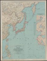
- Beinecke Rare Book and Manuscript Library > Japan and adjacent regions of Asia and the Pacific Ocean [cartographic material] / compiled and drawn in the Cartographic Section of the National Geographic Society. James M. Darley, chief cartographer.
- Creator:
- National Geographic Society (U.S.). Cartographic Division
- Published / Created:
- 1944
- Call Number:
- 556 1944A
- Container / Volume:
- BRBL_00293
- Image Count:
- 1
- Resource Type:
- Maps, Atlases & Globes
- Found in:
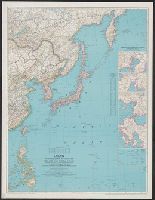
- Beinecke Rare Book and Manuscript Library > Japan and adjacent regions of Asia and the Pacific Ocean [cartographic material] / compiled and drawn in the Cartographic Section of the National Geographic Society. James M. Darley, chief cartographer.
- Creator:
- United States. Army Map Service
- Published / Created:
- 1945
- Call Number:
- 574gm 1945A
- Container / Volume:
- BRBL_00311
- Image Count:
- 1
- Resource Type:
- Maps, Atlases & Globes
- Found in:
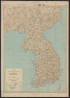
- Beinecke Rare Book and Manuscript Library > Japan road map 1:1,000,000. sheet 4, Korea / prepared under the direction of the Chief of Engineers, U.S. Army, by the Army Map Service (GD) ... 1945.
- Creator:
- United States. Army Map Service
- Published / Created:
- [19]45.
- Call Number:
- 275gm 1945
- Container / Volume:
- BRBL_00023C
- Image Count:
- 1
- Resource Type:
- Maps, Atlases & Globes
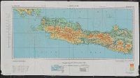
- Found in:
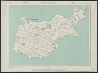
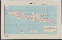
- Beinecke Rare Book and Manuscript Library > Java; special strategic map.
- Creator:
- United States. Army Map Service
- Published / Created:
- 1945
- Call Number:
- 574 C444 1945
- Container / Volume:
- BRBL_00311
- Image Count:
- 1
- Resource Type:
- Maps, Atlases & Globes
- Found in:
- Beinecke Rare Book and Manuscript Library > Korea city plans 1:10,000 : Chinnamp'o (Chinnampo).
- Creator:
- United States. Army Map Service
- Published / Created:
- 1945
- Call Number:
- 574 H17 1945
- Container / Volume:
- BRBL_00311
- Image Count:
- 1
- Resource Type:
- Maps, Atlases & Globes
- Found in:
- Beinecke Rare Book and Manuscript Library > Korea city plans 1:10,000 : Hamhung (Kanko).
- Creator:
- United States. Army Map Service
- Published / Created:
- 1945
- Call Number:
- 574 Y83 1945
- Container / Volume:
- BRBL_00311
- Image Count:
- 1
- Resource Type:
- Maps, Atlases & Globes
- Found in:
- Beinecke Rare Book and Manuscript Library > Korea city plans 1:10,000 : Yosu (Reisui).
- Creator:
- United States. Army Map Service
- Published / Created:
- 1945
- Call Number:
- 574 C442 1945
- Container / Volume:
- BRBL_00311
- Image Count:
- 1
- Resource Type:
- Maps, Atlases & Globes
- Found in:
- Beinecke Rare Book and Manuscript Library > Korea city plans 1:12,500 : Chinhae (Chinkai).
- Creator:
- United States. Army Map Service
- Published / Created:
- 1945
- Call Number:
- 574 Un3 1945
- Container / Volume:
- BRBL_00311
- Image Count:
- 1
- Resource Type:
- Maps, Atlases & Globes
- Found in:
- Beinecke Rare Book and Manuscript Library > Korea city plans 1:20,000 : Unggi (Yuki).
- Creator:
- United States. Army Map Service
- Published / Created:
- 1945
- Call Number:
- 5634gm 1945
- Container / Volume:
- BRBL_00299
- Image Count:
- 1
- Resource Type:
- Maps, Atlases & Globes
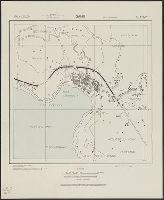
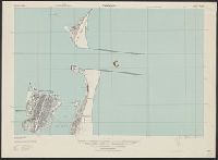
- Found in:
- Beinecke Rare Book and Manuscript Library > Kwangtung Province / prepared under the direction of the Chief of Engineers, by the Army Map Service.
- Creator:
- United States. Army Map Service
- Published / Created:
- 1945
- Call Number:
- 57 K99 1945A
- Container / Volume:
- BRBL_00304
- Image Count:
- 1
- Resource Type:
- Maps, Atlases & Globes
- Found in:
- Beinecke Rare Book and Manuscript Library > Kyoto North : Kyoto Prefecture, Honshu, Japan.
- Creator:
- United States. Army Map Service
- Published / Created:
- 1945
- Call Number:
- 57 K99 1945AA
- Container / Volume:
- BRBL_00304
- Image Count:
- 1
- Resource Type:
- Maps, Atlases & Globes
- Found in:
- Beinecke Rare Book and Manuscript Library > Kyoto South : Kyoto Prefecture, Honshu, Japan.
- Creator:
- United States. Army Map Service
- Published / Created:
- 1943
- Call Number:
- 5844 1943
- Container / Volume:
- BRBL_00315
- Image Count:
- 6
- Resource Type:
- Maps, Atlases & Globes
- Found in:
- Beinecke Rare Book and Manuscript Library > Malaya 1:253 440 : Pahang.
- Creator:
- United States. War Dept. General Staff
- Published / Created:
- [1904?]
- Call Number:
- 565 1910A
- Container / Volume:
- BRBL_00299
- Image Count:
- 6
- Resource Type:
- Maps, Atlases & Globes
- Found in:
- Beinecke Rare Book and Manuscript Library > Manchuria / Second Division, General Staff (Military Information Division).
- Published / Created:
- [1898?]
- Call Number:
- 28 M314 1898
- Container / Volume:
- BRBL_00023F
- Image Count:
- 1
- Resource Type:
- Maps, Atlases & Globes
- Found in:
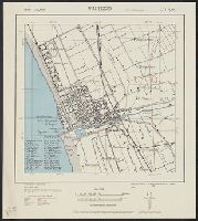
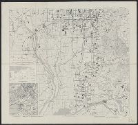
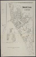
- Beinecke Rare Book and Manuscript Library > Manila, sus arrabales.
- Creator:
- National Geographic Society (U.S.)
- Published / Created:
- c1921.
- Call Number:
- 50 1921
- Container / Volume:
- BRBL_00273
- Image Count:
- 1
- Resource Type:
- Maps, Atlases & Globes
- Found in:
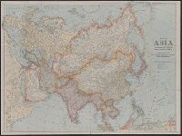
- Beinecke Rare Book and Manuscript Library > Map of Asia and adjoining Europe with a portion of Africa / prepared especially for the National Geographic Magazine, Gilbert Grosvenor, editor.
- Published / Created:
- 1911
- Call Number:
- 794gcf B419 1911
- Container / Volume:
- BRBL_00521
- Image Count:
- 1
- Resource Type:
- Maps, Atlases & Globes
- Found in:
- Beinecke Rare Book and Manuscript Library > Map of Belzoni drainage district, Washington County, Mississippi : showing division of the district into units and the proposed system of ditches and channel improvements.
- Published / Created:
- 1912
- Call Number:
- 98g 1912
- Container / Volume:
- BRBL_00679
- Image Count:
- 1
- Resource Type:
- Maps, Atlases & Globes
- Found in:
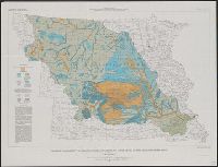
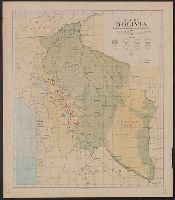
- Beinecke Rare Book and Manuscript Library > Map of Bolivia : showing forest and agricultural areas, and mineral localities.
- Creator:
- Matthews-Northrup Works
- Published / Created:
- 1915
- Call Number:
- 30 1915
- Container / Volume:
- BRBL_00032
- Image Count:
- 1
- Resource Type:
- Maps, Atlases & Globes
- Found in:
- Beinecke Rare Book and Manuscript Library > Map of Europe and adjoining portions of Africa and Asia / prepared especially for the National Geographic Magazine ... by the Matthews-Northrup Works, Buffalo, N.Y.
- Published / Created:
- [1909?]
- Call Number:
- 825 L487 1909A
- Container / Volume:
- BRBL_00574
- Image Count:
- 1
- Resource Type:
- Maps, Atlases & Globes
- Found in:
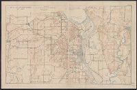
- Beinecke Rare Book and Manuscript Library > Map of Fort Leavenworth, Kansas and vicinity.
- Creator:
- United States. Adjutant-General's Office. Military Information Division
- Published / Created:
- [1898]
- Call Number:
- 855hc 1898A
- Container / Volume:
- BRBL_00765
- Image Count:
- 1
- Resource Type:
- Maps, Atlases & Globes
- Found in:
- Beinecke Rare Book and Manuscript Library > Map of Puerto Rico showing line of march of General Schwan's expedition from Ponce and Yauco to crossing of Rio Prieto August 9-15, 1898 / Chas. H. Ourand.
- Published / Created:
- [1898]
- Call Number:
- 855hc 1898O
- Container / Volume:
- BRBL_00765
- Image Count:
- 1
- Resource Type:
- Maps, Atlases & Globes
- Found in:
- Beinecke Rare Book and Manuscript Library > Map of Santiago de Cuba showing intrenchments and position of the 5th Corps. U.S. Army and those of the Spanish / compiled from partial transit surveys and foot reconnaisance notes and sketches by Lts. Guy, Smith, Cordray. of the Inf.; Lts. Batson and G.P
- Published / Created:
- [1898]
- Call Number:
- 855hc 1898L
- Container / Volume:
- BRBL_00765
- Image Count:
- 1
- Resource Type:
- Maps, Atlases & Globes
- Found in:
- Beinecke Rare Book and Manuscript Library > Map of Santiago de Cuba showing intrenchments and positions of the Fifth Corps. U.S. Army and those of the Spanish after the taking of Caney and San Juan Hill, evening of July 1st, 1898 / compiled from partial transit surveys and foot reconnaisance notes
- Creator:
- United States. Adjutant-General's Office. Military Information Division
- Published / Created:
- [1898]
- Call Number:
- 855hc 1898G
- Container / Volume:
- BRBL_00765
- Image Count:
- 1
- Resource Type:
- Maps, Atlases & Globes
- Found in:
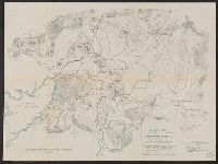
- Beinecke Rare Book and Manuscript Library > Map of battle field of August 10th 1898 : between U.S. regular troops under Brig. Genl. Theodore Schwan, U.S. Volunteers and Spanish forces under Col. Julio Soto Villanueva, Alfonso XIII.
- Published / Created:
- 1919
- Call Number:
- 75gmb AL14 1919
- Container / Volume:
- BRBL_00411
- Image Count:
- 1
- Resource Type:
- Maps, Atlases & Globes
- Found in:
- Beinecke Rare Book and Manuscript Library > Map of the Albert Pike Highway : showing every city, town, village and hamlet throughout its entire length / proposed by the Albert Pike Highway Association.