Search
You Searched For
Search Results
- Creator:
- Jefferys, Thomas, d. 1771
- Published / Created:
- 1794
- Call Number:
- 795cea 1794
- Container / Volume:
- BRBL_00523
- Image Count:
- 1
- Resource Type:
- Maps, Atlases & Globes
- Found in:
- Beinecke Rare Book and Manuscript Library > The western coast of Louisiana and the coast of New Leon / by Thos. Jefferys, geographer to His Majesty.
- Creator:
- Blake, Jacob Edmund, 1811 or 12-1846
- Published / Created:
- 1842?]
- Call Number:
- 796fab Sa13 1842E
- Container / Volume:
- BRBL_00530
- Image Count:
- 1
- Resource Type:
- Maps, Atlases & Globes
- Found in:
- Beinecke Rare Book and Manuscript Library > Part of the boundary between the United States and Texas, north of Sabine River from the 39th [i.e. 36th] to the 72nd mile mound / drawn from the notes of survey and copied for the use of the commissioners under the Convention of 25th April 1838 by J. Edm
- Creator:
- Croskey, Joseph Rodney
- Published / Created:
- 1842
- Call Number:
- 796ad 1842
- Container / Volume:
- BRBL_00529
- Image Count:
- 1
- Resource Type:
- Maps, Atlases & Globes
- Found in:
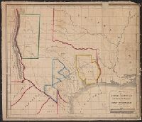
- Beinecke Rare Book and Manuscript Library > Map of the Republic of Texas, exhibiting the property of John Woodward / drawn by Joseph Rodney Croskey.
- Creator:
- Lee, Thomas Jefferson, 1808-1891
- Published / Created:
- 1842?]
- Call Number:
- 796fab Sa13 1842J
- Container / Volume:
- BRBL_00530
- Image Count:
- 1
- Resource Type:
- Maps, Atlases & Globes
- Found in:
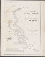
- Beinecke Rare Book and Manuscript Library > Sabine Pass and mouth of the river Sabine in the sea / surveyed under the direction of Major J.D. Graham, U.S. Top.l Engineers ; by Lieut. T.J. Lee, U.S. Top.l Engineers and Cap.t P.J. Pillans, Texan Army, attached to the Joint Commission for marking the
- Creator:
- Asher & Adams
- Published / Created:
- [1878?]
- Call Number:
- 796fb 1878
- Container / Volume:
- BRBL_00530
- Image Count:
- 1
- Resource Type:
- Maps, Atlases & Globes
- Found in:
- Beinecke Rare Book and Manuscript Library > Asher & Adams' Texas : western portion.
- Published / Created:
- 1841 [i.e. 1842]
- Call Number:
- 796fab 1842
- Container / Volume:
- BRBL_00530
- Image Count:
- 1
- Resource Type:
- Maps, Atlases & Globes
- Found in:
- Beinecke Rare Book and Manuscript Library > A new map of Texas / Day & Haghe, lith.rs to the Queen.
- Creator:
- Blake, Jacob Edmund, 1811 or 12-1846
- Published / Created:
- 1842?]
- Call Number:
- 796fab Sa13 1842D
- Container / Volume:
- BRBL_00530
- Image Count:
- 1
- Resource Type:
- Maps, Atlases & Globes
- Found in:
- Beinecke Rare Book and Manuscript Library > Part of the boundary between the United States and Texas, from Sabine River northward to the 36th mile mound / drawn from the notes of survey and copied for the use of the commissioners under the Convention of 25th April 1838, by J. Edm.d Blake 1st Lieut.
- Published / Created:
- 1860?]
- Call Number:
- 796gme 1860
- Container / Volume:
- BRBL_00531
- Image Count:
- 1
- Resource Type:
- Maps, Atlases & Globes
- Found in:
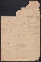
- Beinecke Rare Book and Manuscript Library > A geographically correct map of the Red River, Sabine & Western Railway (under construction) and connections : showing distribution of pine forests (compiled from maps of U.S. government), also location of coal, iron, and oil deposits.
- Creator:
- Asher & Adams
- Published / Created:
- [1878?]
- Call Number:
- 796fb 1878A
- Container / Volume:
- BRBL_00530
- Image Count:
- 1
- Resource Type:
- Maps, Atlases & Globes
- Found in:
- Beinecke Rare Book and Manuscript Library > Asher & Adams' Texas : eastern portion.
- Creator:
- Creuzbaur, Robert
- Published / Created:
- 1850
- Call Number:
- 796 1850
- Container / Volume:
- BRBL_00525
- Image Count:
- 1
- Resource Type:
- Maps, Atlases & Globes
- Found in:
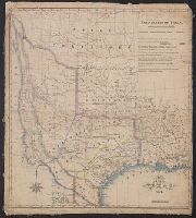
- Beinecke Rare Book and Manuscript Library > J. De Cordova's map of the state of Texas / compiled from the records of the general land office of the state by Robert Creuzbaur ; engraved by J.M. Atwood.
- Creator:
- Austin, Stephen F. (Stephen Fuller), 1793-1836
- Published / Created:
- 1839
- Call Number:
- 796 1839D
- Container / Volume:
- BRBL_00524
- Image Count:
- 1
- Resource Type:
- Maps, Atlases & Globes
- Found in:
- Beinecke Rare Book and Manuscript Library > Map of Texas with parts of the adjoining states / compiled by Stephen F. Austin ; engraved by John & Wm. W. Warr.
- Creator:
- Sandusky, William H
- Published / Created:
- 1845
- Call Number:
- 796 G139 1845B
- Container / Volume:
- BRBL_00527A
- Image Count:
- 1
- Resource Type:
- Maps, Atlases & Globes
- Found in:
- Beinecke Rare Book and Manuscript Library > Plan of the city of Galveston, Texas / by William H. Sandusky ; lith. by Wagner and McGuigan.
- Creator:
- Gray, A. B. (Andrew Belcher), 1820-1862
- Published / Created:
- 1842?]
- Call Number:
- 796fab Sa13 1842I
- Container / Volume:
- BRBL_00530
- Image Count:
- 1
- Resource Type:
- Maps, Atlases & Globes
- Found in:
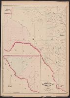
- Beinecke Rare Book and Manuscript Library > Map of the river Sabine from Logan's Ferry to 32nd degree of north latitude : shewing the boundary between the United States of America and the Republic of Texas between said points, as marked and laid down by survey in 1841, under the direction of the Jo
- Published / Created:
- 1837?]
- Call Number:
- 796 H37 1837
- Container / Volume:
- BRBL_00527A
- Image Count:
- 1
- Resource Type:
- Maps, Atlases & Globes
- Found in:
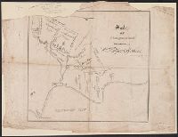
- Beinecke Rare Book and Manuscript Library > Survey of 5 leagues of land belonging to Wm P. Harris & others / lith. of P. Snell.
- Published / Created:
- 19--?]
- Call Number:
- 796 1849A
- Container / Volume:
- BRBL_00524
- Image Count:
- 1
- Resource Type:
- Maps, Atlases & Globes
- Found in:
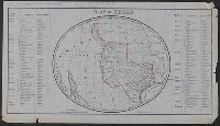
- Beinecke Rare Book and Manuscript Library > Map of Texas / R.B. Moody & Co., Lith.
- Creator:
- J.H. Colton & Co
- Published / Created:
- [1855?]
- Call Number:
- 796 1855
- Container / Volume:
- BRBL_00525
- Image Count:
- 1
- Resource Type:
- Maps, Atlases & Globes
- Found in:
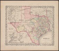
- Beinecke Rare Book and Manuscript Library > Texas.
- Creator:
- Orleman, L. H
- Published / Created:
- 1874
- Call Number:
- 796 1874B
- Container / Volume:
- BRBL_00526
- Image Count:
- 1
- Resource Type:
- Maps, Atlases & Globes
- Found in:
- Beinecke Rare Book and Manuscript Library > Map of parts of Indian Territory, Texas, and New Mexico / compiled by order of Bvt. Maj. Genl. J.W. Davidson, U.S.A., commanding Fort Sill Ind. Ter. ; by Lieut. L.H. Orleman, 10th Cavalry ; lithographed at head quarters mil. div. of the mo., by Askevold &
- Creator:
- Blake, Jacob Edmund, 1811 or 12-1846
- Published / Created:
- 1842?]
- Call Number:
- 796fab Sa13 1842F
- Container / Volume:
- BRBL_00530
- Image Count:
- 1
- Resource Type:
- Maps, Atlases & Globes
- Found in:
- Beinecke Rare Book and Manuscript Library > Part of the boundary between the United States and Texas, north of the Sabine River from the 72nd mile mound to Red River / drawn from the notes of survey and copied for the use of the commissioners under the Convention of 25th April, 1838 by J. Edm.d Bla
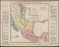
- Creator:
- Finlayson, J. (James)
- Published / Created:
- 1822]
- Call Number:
- 88 1822A
- Container / Volume:
- BRBL_00644
- Image Count:
- 1
- Resource Type:
- Maps, Atlases & Globes
- Found in:
- Beinecke Rare Book and Manuscript Library > Geographical, statistical, and historical map of Mexico : prepared from Humboldt's map & other documents / by J. Finlayson ; engrav'd by Young & Delleker.
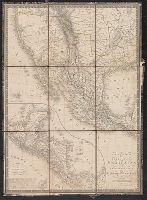
- Creator:
- Brué, A. (Adrien Hubert), 1786-1832
- Published / Created:
- 1825
- Call Number:
- 88 1825
- Container / Volume:
- BRBL_00644
- Image Count:
- 1
- Resource Type:
- Maps, Atlases & Globes
- Found in:
- Beinecke Rare Book and Manuscript Library > Carte générale des États-Unis Mexicains et des Provinces-Unies de l'Amérique Centrale / redigée par Brué ...