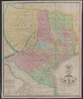
"The latitude and longitude of Saltillo, Monterey, Laredo, Bexar, Nacogdoches, and the point where the boundary line leaves the Sabine are from the observations of General Teran of the Mexican Army.", From the Streeter collection., and Includes coat of arms, "note", and table of numbers of families on principal tracts of land.
Publisher:
H.S. Tanner,
Subject (Geographic):
Texas--Maps
Subject (Name):
Mier y Teran, Manuel de, Streeter, Thomas W.--(Thomas Winthrop),--1883-1965--Ownership, Tanner, Henry Schenck, 1786-1858, Warr, John, b. ca. 1798, and Warr, William W
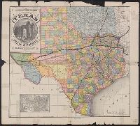
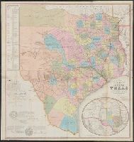
Includes ill. of "Court House, Paris, Texas" and inset of United States., Prime meridians: Greenwich and Washington., and Shows counties, boundary of lands granted to Texas & Pacific Railway, and railroad lines for the Texas & Pacific Railway Co., Fort Worth & Denver City Railway Co., Missouri Pacific Railway Co., Houston & Texas Railway Co., International & Great Northern Railroad, Galveston, Harrisburg & San Antonio Railway Co., Houston, East and West Texas Railway, New Orleans Pacific Railroad Co., and Texas & New Orleans Railroad.
Publisher:
Land Dept. of the Texas & Pacific Railway Co.,
Subject (Geographic):
Texas--Administrativeandpolitical
Subject (Name):
Texas & Pacific Railway. Land Dept and Texas & Pacific Railway--Maps
Subject (Topic):
Railroad land grants--Texas--Maps and Railroads--Texas--Maps
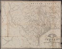
"Entered according to an act of Congress in the year 1845, by R.W. Fishbourne in the clerk's office of the U.S. District Court, district of Louisiana.", Prime meridians: Greenwich and Washington., Relief shown by hachures., and Shows counties, Fisher & Miller's Colony, five grants to C.F. Mercer, "Route of the Santa Fé Expedition in 1841," "Old route from Santa Fé to San Antonio," and "Route of the Texian Prisoners from Santa Fé to the City of Mexico."
"55" and "56" in right margin., "Entered according to act of Congress in the year 187[?] by Asher & Adams in the office of the Librarian of Congress at Washington.", From the Streeter collection., Includes map of "Portion of Texas.", Prime meridians: Greenwich and Washington., and Shows counties and railroads.
Publisher:
Asher & Adams,
Subject (Geographic):
Texas--Administrativeandpolitical
Subject (Name):
Streeter, Thomas W.--(Thomas Winthrop),--1883-1965--Ownership
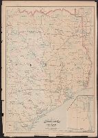
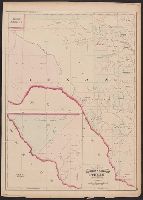
"57" and "58" in right margin., "Entered according to act of Congress in the year 187[?] by Asher & Adams in the office of the Librarian of Congress at Washington.", From the Streeter collection., Includes ancillary map of "Texas, western portion" showing El Paso and Presidio counties., Prime meridians: Greenwich and Washington., and Shows counties and "Texas Pacific R.R."
Publisher:
Asher & Adams,
Subject (Geographic):
Texas--Administrativeandpolitical
Subject (Name):
Streeter, Thomas W.--(Thomas Winthrop),--1883-1965--Ownership
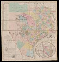
"Entered according to Act of Congress on the 28th day of July 1848 by J. De Cordova in the Clerks Office of the United States District Court for the District of Texas.", "Without my signature all copies of this map have been fraudulently obtained. J. De Cordova.", From the Streeter collection., Includes elliptical inset of southwestern U.S. and Mexico. Scale [ca. 1:9,000,000]., Includes list of land districts and text., Library's copy annotated in pencil and red ink., Prime meridians: Greenwich and Washington., Relief shown by hachures., and Shows counties.
Publisher:
s.n.],
Subject (Geographic):
Texas--Administrativeandpolitical
Subject (Name):
Atwood, John M., b. ca. 1818, De Cordova, Jacob, 1808-1868, and Streeter, Thomas W.--(Thomas Winthrop),--1883-1965--Ownership
"Entered according to act of Congress on the 28th day of July 1848 by J. De Cordova in the clerk's office of the United States district court for the district of Texas.", "Without my signature all copies of this map have been fraudulently o, and Shows counties.
Publisher:
s.n.],
Subject (Geographic):
Texas--Administrativeandpolitical
Subject (Name):
Atwood, John M., b. ca. 1818 and De Cordova, Jacob, 1808-1868
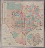
Includes elliptical inset of southwestern U.S. and Mexico. Scale [ca. 1:9,000,000]., Includes list of land districts and text., Library's copy imperfect: Holes in center and upper left., Prime meridians: Greenwich and Washington., Relief shown, and Shows counties.
Publisher:
s.n.],
Subject (Geographic):
Texas--Administrativeandpolitical
Subject (Name):
Atwood, John M., b. ca. 1818 and De Cordova, Jacob, 1808-1868